Stratigraphy of Vertebrate Fossils from Niobrara Chalk
The Smoky Hill Chalk member of the Niobrara Chalk of western Kansas is
famous for vertebrate fossils. Many fossils were collected in the late
1800’s and early 1900’s, before the stratigraphy of the Niobrara
Chalk was adequately understood; hence, stratigraphic information for
many of these specimens is lacking. A new article published in the Survey’s
online Current Research bulletin demonstrates a technique to
determine stratigraphic positions of specimens collected long ago. The
article, Inferring Stratigraphic Position of Fossil Vertebrates from
the Niobrara Chalk of Western Kansas, by S. Christopher Bennett,
was submitted in June and published in September 2000, an example of the
quick turnaround possible with online publication.
This article, along with previously published articles in the Current
Research in Earth Sciences, can be viewed at www.kgs.ku.edu/Current.
Kimberlite PIC
Kimberlites, rare igneous rocks that are the source of diamonds, are described
in a new Public Information Circular, written by Pieter Berendsen, Tom
Weis, and Kevin Dobbs. In Kansas, thirteen kimberlites have been identified
so far, twelve in Riley County and one in Marshall County. Copies of Kansas
Kimberlites (Public Information Circular 16) can be obtained free
of charge by contacting Publications Sales at the KGS. These circulars
also are available electronically through the Survey’s World Wide
Web site at www.kgs.ku.edu.
Woodson County Geologic Map
A new, full-color geologic map of Woodson County was released recently
by the KGS. Geologic maps show the age and type of rock at the earth’s
surface and are useful in a variety of construction, engineering, and
environmental purposes, along with providing basic geologic information.
One notable geologic feature in southern Woodson County is an area of
once-molten igneous rock that crops out at the surface. Igneous rocks
are unusual in Kansas, where almost all of the surface rocks are sedimentary
rocks, such as limestones and shales. The map was developed by Survey
geologist Dan Merriam and is drawn at a scale of 1:50,000, so that one
inch on the map equals about 3/4 mile. Copies of the new map are available
from the KGS.The cost is $15.00, plus tax, shipping, and handling.
New
Publications
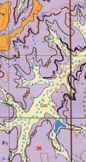
Segment of Woodson County
Geologic Map.
To
celebrate the third annual Earth Science Week (October 8–14), the
Kansas Geological Survey sponsored a public field trip to look at the
rocks and fossils of northeastern Kansas. The field trip on Saturday,
October 7, 2000, gave the public a general introduction to the geology
of the region.
The trip made several stops in the Lawrence and
Topeka area. Participants learned about basic bedrock geology at Clinton
Lake spillway, viewed evidence of Ice Age glaciers, and investigated sandstone
deposits left by an ancient river at Echo Cliff near Dover. The trip’s
final stop was a roadcut with numerous fossils of invertebrate animals
that lived during the Pennsylvanian Period, about 300 million years ago.
Earth Science Week was established in 1998 by the
American Geological Institute to educate people about the Earth and earth
sciences. Helping the public learn about local geology is one of the goals
of this year’s Earth Science Week celebration. To request an information
kit, volunteer to help, or find out what’s happening in other regions,
visit the Earth Science Week Web Site at www.earthscienceworld.org.
Field Trip Kicks off Earth Science Week
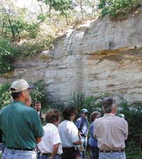
The sandstones at Echo Cliffs in Waubaunsee County were discussed at one of the stops.
URL:http://www.kgs.ku.edu/Publications/GeoRecord/2000/vol6.3/Page3.html