Kansas Geological Survey, Subsurface Geology 6, p. 74-78
by
Douglas H. Rofheart
Mobil Exploration and Producing Services, Inc.
An Acrobat PDF file containing the complete paper is available (228 kB). Sheet containing figure 4 is in a separate file, linked below.
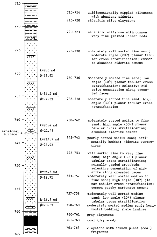
M. C. Colt 26AO Johnson (fig. 1) exhibits features indicative of multistoried sand bodies deposited by meandering fluvial channels. The cored interval shows an erosional base, planar tabular cross-stratified sand that decreases in grain size vertically from medium to fine sand, and an erosional surface at midcore. This erosional surface is the contact between an older fluvial point-bar deposit and a similar younger deposit. The upper sand also shows a vertical decrease in grain size and is overlain by fine-grained overbank deposits. The overbank deposits are composed of interbedded sand and shale and show unidirectional current ripples. The multistoried sand-body geometry exhibited in Colt 26AO Johnson can be used to generate predictive models of reservoir characteristics. This model can then be used to develop an enhanced oil-recovery program.
Figure 1--Stratigraphic section of M. C. Colt 26AO Johnson, sec. 33, T. 24 S., R. 21 E., Allen County, Kansas.
The Bronson-Xenia field in Allen County, Kansas, produces from the Bluejacket Sandstone of the Middle Pennsylvanian (Desmoinesian) Cherokee Group (fig. 2). A geologic study of this field was conducted using data acquired from 167 wells in order to gain an understanding of the reservoir characteristics. Data consisted of geophysical gamma-ray logs and nine full-diameter drill cores from the core repository of the Kansas Geological Survey. The purpose of the study was to three-dimensionally model the reservoir based on depositional environment, diagenesis, petrophysics, and reservoir geometry. A model of this nature can be used as an outline when devising an enhanced-recovery project. The Bronson-Xenia field is particularly well suited for a study of this type because of an unusually close well spacing (1.5 acres).
Figure 2--Stratigraphic section of southeast Kansas (after Zeller, 1968).
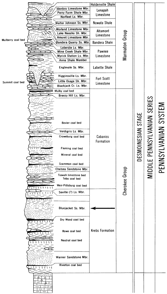
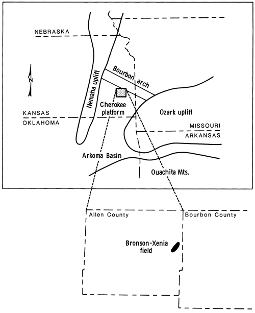
The Bluejacket Sandstone occurs in the surface and subsurface of southeastern Kansas, southwestern Missouri, and northeastern Oklahoma. The Cherokee Basin, a shelf-like extension of the Arkoma Basin of Oklahoma, is bordered on the west by the Nemaha uplift and on the east by the Ozark uplift (fig. 3). The Bourbon arch, a low-relief topographic feature of the pre-Pennsylvanian surface, separates the Cherokee Basin from the Forest City Basin to the north. The thickness of the Desmoinesian stratigraphic section in the Cherokee Basin ranges from 110 m to 275 m and dips to the west-northwest (Ebanks and James, 1974).
Figure 3--Structural setting and field location of M. H. Colt 26AO Johnson.
Middle Pennsylvanian sediments accumulated during an overall transgression as evidenced by the change from predominantly clastics in the Cherokee Group to carbonates in the Marmaton Group (Weirich, 1953; Visher et al., 1971; Ebanks and James, 1974). This transgression was interrupted by several regressive periods, which resulted in the deposition of lenticular "shoestring" sandstones, shale, and coal. Deposition of Cherokee Group sediments occurred in a diversity of environments that included shifting and prograding alluvial and deltaic plains, beaches, shallow seas, and tidal delta complexes (Rick, 1923; Visher et al., 1971; Ebanks and James, 1974).
The reservoir sands of the Bronson-Xenia field were deposited by highly sinuous, low-gradient meandering fluvial channels in an overall fluvio-deltaic setting. The fluvial channels migrated through highly vegetated swamps and marshes as evidenced by the thin Dry Wood coal bed that directly underlies the Bluejacket Sandstone. The Colt 26AO Johnson core (fig. 1) shows lithologies, sedimentary structures, and textural features characteristic of deposits of this type. A gradual upward decrease in sand-grain size and scale of sedimentary structure is indicative of point-bar deposition in a meandering fluvial system (Visher, 1965). The Bluejacket Sandstone core from 26AO Johnson also exhibits unidirectional cross stratification, an erosional base (?), rare bioturbation, and complete absence of marine fossils. The basal sands of the Bluejacket are not composed of well-developed lag deposits but generally show minor shale clasts, wood fragments, and iron-claystone nodules. Overbank deposits consist of unidirectionally rippled very fine sand, siltstone, and interbedded sand and shale commonly showing lenticular bedding.
Gamma-ray logs were used to construct net-sand isopach maps in order to delineate the geometry of the Bronson-Xenia reservoir (fig. 4). The overall geometry of the reservoir is that of a blanket-like sand with irregular, highly variable thickness. Previous studies reported an elongate, lenticular geometry for Cherokee Group sandstones deposited in similarly interpreted depositional environments (Hulse, 1978; Maderak, 1960). A fence diagram of the Bronson-Xenia field was constructed in an attempt to determine if the resultant sand geometry was actually multilateral sand bodies. Four "shoestring" sand bodies were outlined based on nine core descriptions and 167 gamma-ray logs that commonly showed two or more distinct sand units. The gamma-ray logs were supported by 100 core descriptions conducted by Daniel A. Busch, the consulting geologist for Mack C. Colt, Inc. The contact between sand bodies commonly showed erosional features such as truncation of crossbeds, common shale clasts or wood fragments, and an increase in sand-grain size. Colt 26AO Johnson has an erosional surface at 743 ft that truncates crossbedding and shows an increase in grain size from fine to medium sand across the contact. Colt 26AO Johnson is anomalous because it does not contain shale clasts or wood fragments above this contact. Above the erosional surface, the vertical sequence of sedimentary structures and decreasing grain sizes represents a second generation of point-bar deposition.
In order to develop an efficient and effective enhanced oil-recovery (EOR) project, a three-dimensional model of the reservoir must be constructed. This model, which is based on reservoir geometry, depositional environment, diagenesis, and petrophysics, can be utilized to delineate high permeability zones in the reservoir. A successful EOR project will result from maximum areal sweep of the reservoir. Portions of the reservoir that have lower permeabilities and higher residual oil saturations can be swept by adopting a suitable fluid-injection pattern. A clear understanding of fluid-migration patterns in the reservoir can assure that residual oil is contacted by the displacing fluid and that expensive injection fluids will not be lost.
Ebanks, W. J., Jr., and James, G. W., 1974, Heavy crude oil-bearing sandstones of the Cherokee Group (Desmoinesian) in southeastern Kansas; in, Oil Sands, Fuel of the Future: Canadian Society of Petroleum Geologists, Memoir 3, p. 19-34.
Hulse, W. J., 1978, A geologic study of the Sallyards field area, Greenwood County, Kansas: M.S. thesis, University of Kansas.
Maderak, M. L., 1960, A facies study of the Desmoinesian Series in the Forest City Basin: M.S. thesis, Kansas State University.
Rich, J. L., 1923, Shoestring sands of eastern Kansas: American Association of Petroleum Geologists, Bulletin, v. 7, p. 103-113.
Visher, G. S., 1965, Fluvial processes as interpreted from ancient and recent fluvial deposits; in, Primary Sedimentary Structures: Society of Economic Paleontologists and Mineralogists, Special Publication 12, p. 116-132.
Visher, G. S., Saitta, B. S., and Phares, R. S., 1971, Pennsylvanian delta patterns and petroleum occurrences in eastern Oklahoma: American Association of Petroleum Geologists, Bulletin, v. 55, p. 1,206-1,230.
Weirich, T. E., 1953, Shelf principle of oil origin, migration, and accumulation: American Association of Petroleum Geologists, Bulletin, v. 37, p. 2,027-2,045.
Kansas Geological Survey
Comments to webadmin@kgs.ku.edu
Web version April 14, 2010. Original publication date 1985.
URL=http://www.kgs.ku.edu/Publications/Bulletins/Sub6/Rofheart/index.html