Kansas Geological Survey, Subsurface Geology 6, p. 66-73
by
John W. Harris
Kansas Geological Survey
An Acrobat PDF file containing the complete paper is available (584 kB). Sheet containing figure 4 is in a separate file, linked below.
The Cherokee Group of southeastern Kansas consists of interbedded shale, sandstone, coals, and thin limestone beds that were deposited in a variety of marginal-marine environments. The discontinuous nature of reservoir sandstones, patchy distribution of subsurface control, and problems in surface correlation of coal beds and other associated units make regional stratigraphic studies difficult. Descriptions of 24 continuous cores of the Cherokee Group from Cherokee and Crawford counties, Kansas, resulted in a detailed stratigraphic model that may be extended farther into the subsurface or to the outcrop belt. Several thin, unnamed, but laterally persistent coal beds were encountered. These coal beds and overlying radioactive shales are the most persistent units, are easily identified on gamma-ray /neutron-well logs, and thus may be used as subsurface stratigraphic marker beds.
The Cherokee Group (Desmoinesian Stage, Middle Pennsylvanian Series) consists of interbedded sandstones, shales, coals, and thin lenticular limestones that represent the oldest deposits of Pennsylvanian age in eastern Kansas. Sandstones of the Cherokee Group are important reservoir rocks, and over a half billion barrels of oil have been produced mainly from stratigraphic traps (Ebanks and James, 1974). In addition, over 200 million tons of coal have been mined and over 285 million tons of demonstrated coal reserves have been identified within the Cherokee Group (Brady, Livingston, and Adams, 1974). The complex stratigraphy of the Cherokee Group results from deposition in marginal-marine and shallow-marine environments, and several previous workers have encountered difficulties with correlation of stratigraphic units (Pierce and Courtier, 1937; Moore, 1950; Howe, 1956; Searight and Howe, 1961; and Ebanks, James, and Livingston, 1977). The continuous cores used in this study allow correlation of thin units and permit the development of a detailed subsurface stratigraphic model.
The area of stratigraphic evaluation extends from the outcrop belt of the Cherokee Group, northwestward into the subsurface, and both outcrop and subsurface data were used in this study. A total of 24 continuous cores from Cherokee and Crawford counties, Kansas, formed the foundation for detailed stratigraphic correlations. The cores are "BX" cores, 1 5/8 inches in diameter, and extend from bedrock to the top of the Mississippian limestone, providing continuous sections of the Cherokee Group. Twenty-two cores were donated to the Kansas Geological Survey by Gulf Mineral Resources Company, and two additional cores were provided by the U.S. Office of Surface Mining (OSM). Initial descriptions of these cores were completed at a scale of 1 inch equals 1 ft (8 cm = 1 in) using a checklist to ensure adequate detail and uniformity in the descriptions. A rock color chart (Goddard and others, 1963) was used to determine colors of dry samples of fine-grained rocks. Cores are stored and detailed descriptions are on file in the mineral resources section at the Kansas Geological Survey in Lawrence.
The Cherokee Basin or shelf, including most of the study area, is an elongate extension of the northeast Oklahoma platform. The Cherokee Basin is bounded by the Nemaha ridge on the west, the Ozark uplift on the east, and is separated from the Forest City Basin to the north by the Bourbon arch, a small positive structural feature (Cole, 1969). Rocks of the Cherokee Group were deposited disconformably over a karst surface developed on Mississippian limestones in southeastern Kansas, southwestern Missouri, and northeastern Oklahoma. The upper contact of the Cherokee Group is the base of the Fort Scott Limestone Member of the Marmaton Group (Jewett, O'Connor, and Zeller, 1968). Thickness of the Cherokee Group ranges from less than 300 ft (90 m) in eastern Kansas to over 9,000 ft (2,750 m) in the Arkoma Basin near McAlester, Oklahoma (Oakes, 1953). The outcrop belt of the Cherokee Group in the study area is 12-20 mi (20-32 km) wide, trending northeast- southwest through western Missouri, southeastern Kansas, and eastern Oklahoma. Regional dip may vary locally due to minor structures or differential compaction but averages about 20-30 ft/mi (4-6 m/km) to the west-northwest (Ebanks, James, and Livingston, 1977). Strata of the Cherokee Group were deposited during a major transgressive phase containing minor progradational or regressive pulses. This is evidenced by the successive onlap of younger strata on to positive structural elements as well as the transition from predominantly terrigenous sediments at the base of the Desmoinesian Stage to carbonates at the top (Visher, Saitta, and Phares, 1971; Frezon and Dixon, 1975).
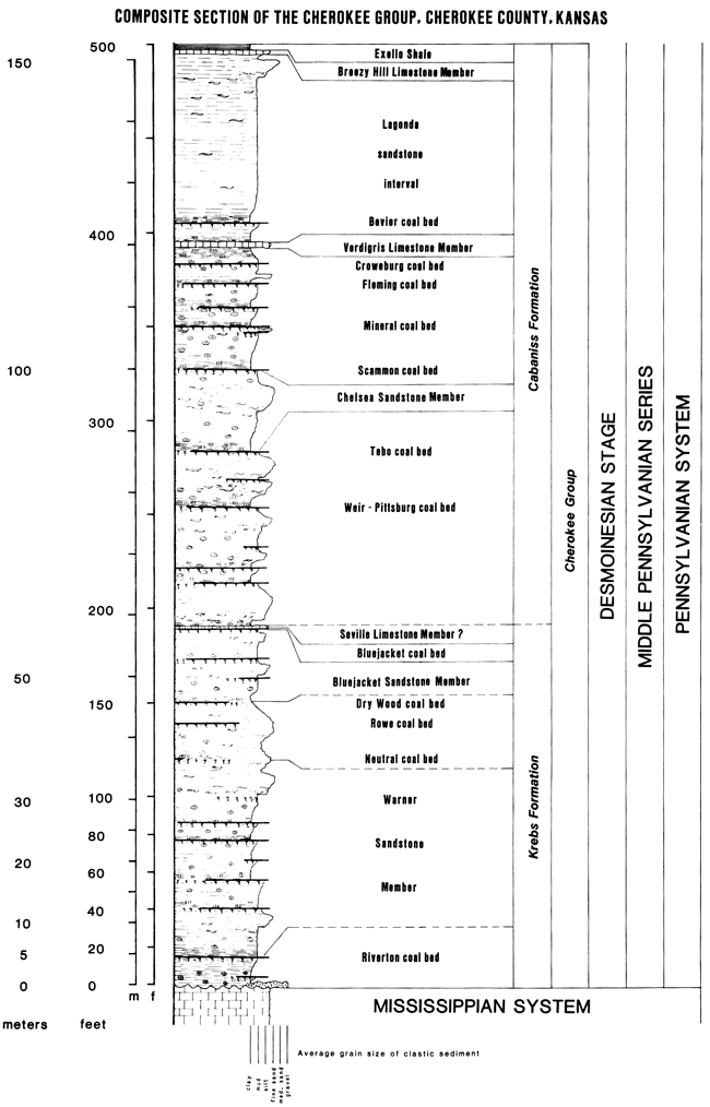
The Cherokee Group was named for exposures in Cherokee County, Kansas, and includes all rocks above the Mississippian limestone and below the Fort Scott Limestone formation. Formal stratigraphic nomenclature of the Cherokee Group in Kansas is summarized in fig. 1, which is a composite section resulting from observations made on 24 continuous cores used in this study. Coal beds and associated rock units described from these cores were named in accordance with the established stratigraphic nomenclature of Jewett, O'Connor, and Zeller (1968) to avoid confusion and addition of new names with the exception of several unnamed coal beds. The contact between the Krebs Formation and the Cabaniss Formation in southeastern Kansas and southwestern Missouri is placed at the top of a thin but widespread argillaceous limestone unit (the Seville Limestone Member). Paleontologic evidence indicates that a significant time-stratigraphic break may exist between the Seville Limestone and overlying units (Howe, 1956). The Seville Limestone, or a limestone at about that stratigraphic position, is present in the cores examined, but this limestone is not easily traceable in the subsurface. Lateral continuity of the thin coal beds has been demonstrated through correlation between numerous surface and underground mines as well as within the cores examined in this study. Coal beds less than 1 ft (30 cm) thick commonly have an areal extent of tens of square miles, and in some cases, hundreds of square miles (Howe, 1956; Wanless, Baroffio, and Trescott, 1969; and Wright, 1975). Therefore, coal beds, associated seatrock horizons, and overlying dark-gray shales are the stratigraphic markers used in this study.
Figure 1--Composite section of the Cherokee Group resulting from description of 24 continuous cores in Cherokee and Crawford counties, Kansas.
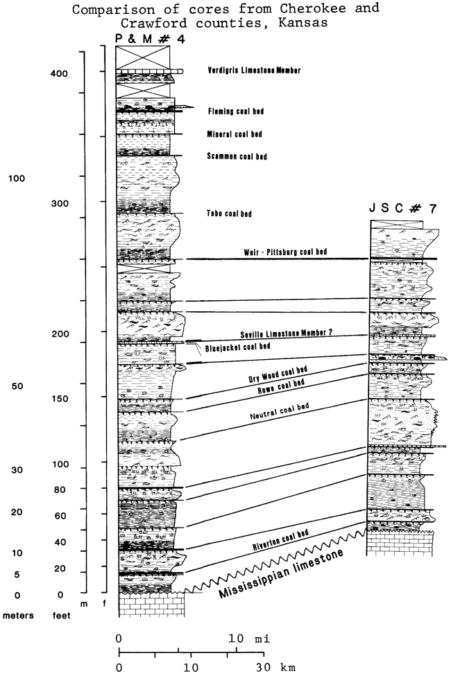
The longest continuous core used in this study, P & M #20 (SE NE NE sec. 8, T. 32 S., R. 22 E.), starts in the Breezy Hill Limestone Member and extends to the top of the Mississippian limestone. This core is 486 ft (148 m) long and has 100% core recovery. The shortest core used in this study, OSM CH-I (SW sec. 27, T. 31 S., R. 24 E.), started approximately 30 ft (9 m) above the Weir-Pittsburg coal bed, extends to about 8 ft (2.5 m) below the Neutral coal bed, and is 152 ft (46 m) long with 98% core recovery. The core displayed at this workshop, P & M #4 (SW NW SW sec. 29, T. 32 S., R. 22 E.), has its top just above the Verdigris Limestone Member and extends to the top of the Mississippian limestone. This core is 411 ft (125 m) long with 96% core recovery. Two core descriptions that summarize the correlations and lateral variability observed in the cores are presented in figs. 2 and 3. Fig. 2 is a map showing the locations of cores and gamma-ray/neutron-well logs used for stratigraphic correlations in this study. Fig. 3 shows the stratigraphic relationships between P & M #4 and JSC #7 (NE SE NE sec. 30, T. 30 S., R. 25 E.). These cores are 22 mi (35 km) apart and the stratigraphic section observed in JSC #7, near the Bourbon arch, is 50 ft (15 m) thinner than the section observed in P & M #4. Most of the coal beds and other stratigraphic markers are present and are traceable in the subsurface for at least 22 mi (35 km) along the strike.
Figure 2--Location of cores and well logs used in stratigraphic cross sections.
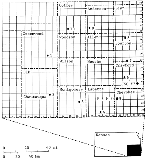
Figure 3--Summary of stratigraphic correlations observed in 24 continuous cores in Cherokee and Crawford counties, Kansas.
The Riverton coal bed usually is the first well-developed coal bed above the Mississippian limestone surface. The Riverton is characterized by a thin but persistent clay parting just above the base of the coal bed. Above the Riverton coal bed and below the Neutral coal bed are four unnamed but laterally persistent coal beds (figs. 1 and 3). These coal beds range in thickness from 1.7 ft (52 cm) to a feather edge. The interval separating the lower two unnamed coal beds is quite variable in thickness, possibly because of a greater degree of localized solution and subsidence in the Mississippian limestones. The upper two of these unnamed coal beds generally are separated by 8-10 ft (2.4-3.0 m) of dark-gray or lenticularly bedded shale and seatrock. This couplet of unnamed coal beds is easily traceable in the subsurface and both coal beds have been used as stratigraphic markers in this study. The Warner Sandstone Member also occurs above the Riverton coal bed and below the Rowe coal bed (Jewett, O'Connor, and Zeller, 1968). At least three sandstone bodies, which may show either coarsening-upwards or fining-upwards sequences, are present in this interval. These various sandstone bodies have been referred to as the lower and upper Warner sandstones (Ebanks, James, and Livingston, 1977).
The Neutral, Rowe, and Dry Wood coal beds are present above the Warner sandstone interval. The Neutral coal bed is erratic in distribution and often is represented in these cores by a seatrock horizon and overlying dark-gray shale in the appropriate stratigraphic position (figs. 1 and 3). The Rowe coal bed occurs about 20 ft (6 m) above the Neutral coal horizon and the Dry Wood coal bed is present about 15-20 ft (4.5-6 m) above the Rowe. The Dry Wood coal bed (and an overlying radioactive shale) are important stratigraphic marker beds used in this study.
Above the Dry Wood coal bed are four thin but laterally persistent coal beds. Overlying the second unnamed coal bed above the Dry Wood is an argillaceous limestone about 1 ft (30 cm) thick that is here considered to be the Seville Limestone Member (Jewett, O'Connor, and Zeller, 1968; figs. 1 and 3). The third unnamed coal bed above the Dry Wood coal bed is commonly overlain by a radioactive shale and has been used as a stratigraphic marker in this study. Several sandstones (with both coarsening- and fining-upwards sequences) encountered in this stratigraphic interval have been called informally the lower and upper Bluejacket sandstones (Ebanks, James, and Livingston, 1977).
The Weir-Pittsburg coal bed occurs 60-70 ft above the Seville Limestone Member. The Weir-Pittsburg coal bed is economically the most important coal bed in the Cherokee Group, and two cores used in this study encountered voids due to underground mining of this coal bed. The Tebo coal bed occurs about 35 ft (10 m) above the Weir-Pittsburg coal bed. A split ranging up to 12 ft (3.5 m) is commonly observed in the Tebo coal bed. The Chelsea Sandstone Member is found between the Tebo coal bed and the Scammon coal bed. The Chelsea Sandstone generally consists of a coarsening-upwards sequence of wavy-bedded siltstone or flaser-bedded sandstone. Above the Chelsea Sandstone Member are found, in stratigraphic order, the Scammon, Mineral, Robinson Branch, Fleming, and Croweburg coal beds. This interval commonly consists of dark-gray shale or lenticular-bedded shale with small amounts of sandstone. The Verdigris Limestone Member is a thin but widespread marine limestone unit found about 8 ft (2.5 m) above the Croweburg coal bed. The Verdigris and the underlying dark-gray shale are easily recognized on gamma-ray/neutron-well logs and are widely used as marker beds in the subsurface. The Bevier coal bed occurs about 5-10 ft (2-3 m) above the Verdigris Limestone Member; above the Bevier coal bed is the Lagonda sandstone interval. The Lagonda interval consists of medium-gray shale, lenticular-bedded shale, and minor amounts of sandstone. This interval ranges in thickness from less than 20 ft (6 m) to over 100 ft (30 m) in the study area. The Breezy Hill Limestone Member occurs above the Lagonda interval. Above the Breezy Hill is a dark-gray, platy shale containing small phosphatic nodules that correlates with the Excello Shale of Missouri and Oklahoma.
Coal beds, seatrock zones, and dark-gray shales are the most laterally persistent lithologic units encountered in the cores used in this study. Coal beds are identified by a low reading on the neutron log and usually a low reading on the gamma-ray log, and often the shales overlying coal beds are highly radioactive. Following comparison between cores and well logs, gamma-ray/ neutron logs were used to construct a stratigraphic cross section covering several counties in southeastern Kansas. Over 150 core descriptions and well logs from Kansas, Missouri, and Oklahoma were utilized in this study and the resulting correlations are summarized in figs. 2, 4A, and 4B. Several coal beds encountered in this study, some unnamed, have proved to be widespread, are easily identified on gamma-ray /neutron logs, and are suitable for subsurface marker beds. Radioactive shales overlying some coal beds also have been used as stratigraphic markers.
The base of the Verdigris Limestone Member is the most reliable marker in the Cherokee Group and has been used as a datum for stratigraphic cross sections shown in figs. 4A and 4B. The Mississippian limestone surface, although irregular, is another reliable marker in the subsurface. The Riverton coal bed and the third and fourth unnamed coal beds above the Riverton are good stratigraphic markers. The Dry Wood coal bed, the third unnamed coal bed above the Dry Wood, the Weir-Pittsburg coal bed, and especially the Tebo coal bed seem to be overlain by radioactive shales that can be traced over much of the study area. The Scammon, Mineral, and Fleming coal beds often are overlain by radioactive shales and have proved to be good marker beds in the Cabaniss Formation. A dark-gray shale below the Verdigris Limestone Member is highly radioactive and has been widely used as a marker bed. Marker beds above the Verdigris Limestone Member include the Bevier coal bed and the base of the Fort Scott Limestone Formation. Several thin coal beds have been encountered in the Lagonda sandstone interval and could be used as marker beds in certain areas.
Dark-gray Shales--Shales that range from dark gray (N2) to medium dark gray (N4) are the most abundant lithofacies. These shales range in thickness from over 25 ft (8 m) to less than 1 ft (30 cm), are hard, and break with a hackly or splintery fracture. Grain size may be either clayshale or mudshale with minor amounts of quartz silt present. Fossils include brachiopod shells and spines, mollusks, gastropods, crinoid columnals, ostracodes, fish scales, and plant fossils (Dr. Doris Zeller, personal communication, 1982). A few small horizontal burrows are present in some layers. Diagenetic features include calcareous cement as well as pyrite, clay ironstone, phosphate, and calcareous concretions. The dark-gray shales are found most commonly overlying coal beds or seatrock zones with sharp lower contacts and generally have gradational upper contacts. The fine grain size of this lithofacies and the abundant pyritization of fossils indicate that deposition occurred under low-energy conditions in a disaerobic or anoxic environment.
Medium- to Light-gray Shales--Shales ranging from medium gray (N5) to very light gray (N8) on the color chart also are present in the cores. This lithofacies may be up to 75 ft (25 m) thick in the upper part of the Cherokee Group. Medium- to light-gray shales are hard and break with a hackly fracture. Mudshale is most common, and minor amounts of dispersed quartz silt and mica are present. Fossils include plant fragments, brachiopods, mollusks, crinoid columnals, and other marine forms, but fossils usually are not as abundant as in the dark-gray shales. Clay ironstone and pyrite concretions as well as carbonate cement are common. Medium- to light-gray shales often overlie dark-gray shales with gradational lower contacts and often grade upwards into lenticular-bedded shale or seatrock.
Lenticular-bedded Shales--Lenticular-bedded shales (Reineck and Wunderlich, 1968) commonly are encountered below or stratigraphically adjacent to sandstone bodies. They generally consist of dark- to medium-gray (N3-N5) mudshale interlaminated with thin (> 1 cm), light-gray (N7) lenses of silt to fine-grained quartz sand. Thickness of this lithofacies generally is less than 20 ft (6.5 m). Lenticular-bedded shales contain plant fragments and both vertical and horizontal burrows, but body fossils are rare. Calcareous cement, pyrite concretions, and clay ironstone concretions are common diagenetic features. Lower contacts generally are gradational with dark- to medium-gray shales, and the abundance of thin sand lenses generally increases upwards within each unit. Upper contacts generally are gradational with siltstone or sandstone.
Claystone and Mudstone--Claystone and mudstone range in color from medium gray (N5) to very light gray (N8), are soft, lack fissility, and break with a blocky fracture. Thicknesses generally are less than 10 ft (3 m). Mudstones commonly contain quartz, silt, and abundant plant fragments. Mudstones and claystones generally exhibit gradational lower contacts with the underlying shale or siltstone, and upper contacts generally are gradational with seatrock or shale.
Wavy-bedded Siltstones--The wavy-bedded (Reineck and Wunderlich, 1968) siltstone facies contains approximately equal amounts of light-gray (N7) rippled siltstone interlaminated with dark- to medium-gray (N3-N5) mudshales. Thickness of this lithofacies may range from over 30 ft (10 m) to less then 3 ft (1 m). Ripples and convolute bedding are common sedimentary structures. Plant fossils, as well as various types of burrows, also are present in the siltstones. Diagenetic features include clay-ironstone spherulites and concretions and zones of calcareous cement. Wavy-bedded siltstones generally have gradational or intercalating lower contacts with either a shale or sandstone. Occasionally a sharp but nonscoured contact is observed below this facies, indicating rapid lateral progradation of a sedimentary environment. Upper contacts with the overlying siltstone or sandstone may be either sharp or gradational.
Rippled Siltstone--The rippled siltstone facies usually is light gray (N7) in color, is less than 10 ft (3 m) thick, and is composed primarily of quartz silt. Ripples are the most common bedforms. Plant fossils are common, and most rippled siltstone facies are burrowed. Lower contacts are usually gradational with the underlying wavy-bedded siltstone or sandstone.
Structureless Siltstones--Structureless siltstones range from medium gray (N5) to light gray (N7) in color and are composed of quartz silt with various amounts of mud matrix. Massive siltstone facies may differ from the other types of siltstones by having a greater degree of bioturbation that has destroyed primary sedimentary structures, or by exposure and leaching.
Mud-clast Conglomerate--Mud-clast conglomerates generally contain locally derived mud clasts, coal clasts, lime-mud clasts, plant fossils, and broken and abraded fragments of marine fossils. Clasts may be up to 2 inches (5 cm) in diameter and usually are set in a matrix of fine quartz sand. This facies usually is massive and has no visible sedimentary structures. A sharp, scoured lower contact generally is present between the conglomeratic facies and the underlying lithology, and upper contacts may be either sharp or gradational with the overlying sandstone.
Large-scale Crossbedded Sandstone--These sandstones generally are light gray (N7) in color and are composed mainly of very fine to fine-grained quartz sand. High-angle sets of crossbeds up to 1 ft (30 cm) in height are the most common sedimentary structure. Plant fragments are the most common fossils. This facies generally has a sharp, scoured lower contact with the underlying lithology and commonly is observed overlying mud-clast conglomerates.
Rippled Sandstone--Rippled sandstones generally are the most abundant sandstone type. This facies is generally light gray (N7) and is made up of very fine to fine-grained quartz sand. Thickness of units is usually less than 10 ft (3 m). Unidirectional current ripples up to 1 inch (2.5 cm) in height are the most common primary sedimentary structures. Plant fossils and a few burrows may be present. Rippled sandstones commonly have gradational or abruptly gradational lower contacts with flaser-bedded sandstone or siltstone. Upper contacts generally are gradational with a siltstone.
Flaser-bedded Sandstones--Flaser-bedded (Reineck and Wunderlich, 1968) sandstones are characterized by the presence of thin (< 1 cm), dark-gray mudstone lenses interlaminated with light-gray rippled sandstone. Ripples are the most common bedforms, and mud flasers are preserved in ripple troughs. Plant fossils and burrows are common. Flaser-bedded sandstones generally have gradational lower contacts with a wavy-bedded siltstone or sandstone and commonly are overlain by rippled or large-scale crossbedded sandstone.
Structureless Sandstone--This sandstone facies ranges in color from medium gray (N5) to light gray (N7) and is composed of fine-grained quartz sand in a mud matrix. No sedimentary structures are apparent, and this facies could also be the result of increased bioturbation or exposure and leaching.
Mudstone to Wackestone--Limestones of the Cherokee Group, although thin, may be laterally widespread and are important because of their use as marker beds and in stratigraphic subdivision. The Verdigris Limestone Member is generally a light-gray (N7) lime mudstone to wackestone, containing brachiopods, bivalves, crinoids, bryozoans, and carbonate mud. Such units generally show no sign of bedding features. Both upper and lower contacts either are gradational or abruptly gradational with the surrounding shale. Some large cone-in-cone structures as well as elongate calcareous nodules have been observed in both cores and outcrops. Therefore, distinguishing between such diagenetic features and true carbonate sediments is important.
Argillaceous Limestone--Argillaceous limestones commonly are found within dark-gray shales overlying coal beds. These limestones range from dark gray (N3) to medium gray (N5) in color and are usually less than 1 ft (30 cm) in thickness. Fossils include brachiopods, mollusks, gastropods, bryozoans, and crinoid columnals. These fossils are set in a matrix of dark-gray clay or mud, perhaps introduced by burrowing. These argillaceous limestones have sharp or abruptly gradational contacts with the surrounding lithology.
Coal beds encountered in the cores examined ranged from 2.5 ft (0.75 m) to less than 1 inch (2.5 cm) in thickness. Coal beds are bituminous in rank, black in color, bright to moderately bright banded, and have a blocky fracture. Calcareous cement and sulfate minerals are present in cleats and fractures. Coal beds have sharp upper and lower contacts. These thin coal beds, the associated seatrock zones, and the overlying dark-gray shales seem to be laterally persistent and are used for stratigraphic correlations.
Seatrock, also known as "underclay," "fireclay," and "seatearth," commonly is found below coal beds but also can be found where no coal bed is present. Seatrock is usually a lighter gray color than the surrounding units, and thicknesses are generally less than 6 ft (2 m). Seatrock zones contain clay, silt, sand, or thin argillaceous limestone beds, and abundant plant and root fragments are nearly always present. Seatrock is soft to moderately hard, breaks with a blocky or conchoidal fracture, and may have a soapy feel. Some claystone or mudstone seatrock units contain slickensides. Iron carbonate and altered pyrite concretions are common and are often concentrated in the lower portion of the unit. The lower contact of a seatrock unit is usually gradational with the underlying lithology. Seatrock generally has a sharp upper contact with the overlying coal bed or dark-gray shale, indicating a break in sedimentation. Seatrock units are believed to represent ancient soil horizons on top of which coal swamps developed. Explanation of lithofacies symbols used in stratigraphic sections is given in fig. [4].
Research for this project was supported in part by the U.S. Geological Survey, Department of the Interior, under USGS Agreement No. 14-080001-G704. Special thanks are extended to Dr. Lawrence Brady of the Kansas Geological Survey for his critique of the manuscript as well as his support throughout the course of this study and to Dr. Anthony W. Walton, Department of Geology, The University of Kansas, for reviewing the manuscript and providing many valuable suggestions incorporated into this report. I also appreciate the assistance of Dave B. Killen who helped with core preparation and drafting.
Brady, L. L., Livingston, N. L., and Adams, D. B., 1976, An evaluation of the strippable coal reserves in Kansas: Kansas Geological Survey, Mineral Resources Series 5, 40 p. [available online]
Cole, J. G., 1969, Cherokee Group, east flank of the Nemaha ridge, north-central Oklahoma: Shale Shaker, pt. 1, v. 19, no. 9, p. 150-161.
Ebanks, W. J., Jr., and James, G. W., 1974, Heavy crude oil-bearing sandstones of the Cherokee Group (Desmoinesian) in southeastern Kansas; in, Oil Sands, Fuel of the Future: Canadian Society of Petroleum Geologists, Memoir 3, p. 19-34.
Ebanks, W. J., Jr., James, G. W., and Livingston, N. D., 1977, Evaluation of heavy-oil and tar sands in Bourbon, Crawford, and Cherokee counties, Kansas--final report: U.S. Department of Energy, BERC/RI-77/20, 110 p.
Frezon, S. E., and Dixon, G. H., 1975, Texas panhandle and Oklahoma; in, Paleotectonic investigations of the Pennsylvanian System in the United States, part I--Introduction and Regional Analysis of the Pennsylvanian System: U.S. Geological Survey, Professional Paper 853, p. 177-195. [available online]
Goddard, E. N., and others, 1963, Rock Color Chart: Geological Society of America.
Howe, W. B., 1956, Stratigraphy of pre-Marmaton Desmoinesian (Cherokee) rocks in southeastern Kansas: Kansas Geological Survey, Bulletin 123, 132 p. [available online]
Jewett, J. M., O'Connor, H. G., and Zeller, D. E., 1968, Pennsylvanian system; in, The stratigraphic succession in Kansas, D. E. Zeller, ed.: Kansas Geological Survey, Bulletin 189, p. 21-43. [available online]
Moore, R. C., 1950, Late Paleozoic cyclic sedimentation in the central United States: Great Britain, 18th International Geologic Congress Report, pt. 4, p. 5-16.
Oakes, M. C., 1953, Krebs and Cabaniss Groups of Pennsylvanian age in Oklahoma: American Association of Petroleum Geologists, Bulletin, v. 37, p. 1,523-1,526.
Pierce, W. G., and Courtier, W. H., 1937, Geology and coal resources of the southeastern Kansas coal field: Kansas Geological Survey, Bulletin 24, 122 p. [available online]
Reineck, H. E., and Wunderlich, F., 1968, Classification and origin of flaser and lenticular bedding: Sedimentology, v. 11, p. 99-104.
Searight, W. V., and Howe, W. B., 1961, Pennsylvanian System; in, The Stratigraphic Succession in Missouri, J. W. Koenig, ed.: Missouri Division of Geological Survey and Water Resources, Second Series, v. 40, p. 78-122.
Visher, G. S., Saitta, B. S., and Phares, R. S., 1971, Pennsylvanian delta patterns and petroleum occurrences in eastern Oklahoma: American Association of Petroleum Geologists, Bulletin, v. 55, no. 8, p. 1,206-1,230.
Wanless, H. R., Baroffio, J. R., and Trescott, P. C., 1969, Conditions of deposition of Pennsylvanian coal beds: Geological Society of America, Special Paper 114, p. 105-142.
Wright, C. R., 1975, Environments of deposition within a typical Pennsylvanian cyclothem; in, Paleotectonic Investigations of the Pennsylvanian System in the United States, pt. II-Interpretive Summary and Special Features of the Pennsylvanian System: U.S. Geological Survey, Professional Paper 853, p. 73-85. [available online]
Kansas Geological Survey
Comments to webadmin@kgs.ku.edu
Web version April 14, 2010. Original publication date 1985.
URL=http://www.kgs.ku.edu/Publications/Bulletins/Sub6/Harris/index.html