Kansas Geological Survey, Subsurface Geology 6, p. 36-39
by
Bill Coffey
TXO Production Corporation
An Acrobat PDF file containing the complete paper is available (140 kB).
A core representative of the Brandt-Sensenbaugh field was taken in order to provide more detailed information concerning the depositional environment and reservoir quality of the Mississippian pay. Because of the mature nature of the field, pertinent information such as electric logs, detailed geologic logs, and accurate production tests are either lacking or unavailable. This core provided the necessary data to form a more complete geologic setting of this field.
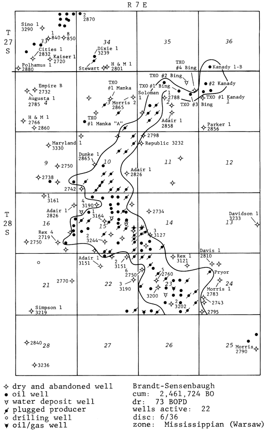
The Brandt-Sensenbaugh field was opened in June 1936, and by 1945, its productive limits were thought to have been reached. More recent infield drilling in the 1950's-1960's encountered new reserves, but in 198 1, new production was discovered 1/2 mi from the northeast portion of the field, thus renewing interest in this Mississippian pay (fig. 1).
In order to perform accurate and descriptive facies studies, subsurface data including electric and geologic logs are a requirement. The recent field extensions prompted this need because of the potential for new reserves. As this field was initially developed during the 1930's and 1940's, most production was discovered with cable-tool drilling techniques. Further, electric logs were not utilized, and geologic logs either were not kept or were lost in the 40 yrs since their initial use. A core of the Mississippian pay helped to fill this lack of data.
Figure 1--Location map of Brandt-Sensenbaugh field, Butler County, Kansas (courtesy TXO Production).
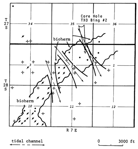
To briefly summarize the result of this core analysis, figs. 2 and 3 are the respective graphic core description and porosity log of the subject well. The resulting general map of facies distribution is seen in fig. 4.
Figure 2--Core description of Bing #2, sec. 2, T. 28 S., R. 7 E., Butler County, Kansas (courtesy TXO Production).
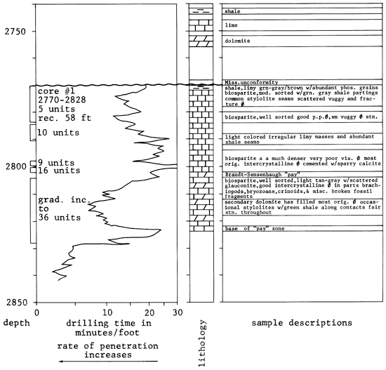
Figure 3--Gamma ray/neutron density log for Bing #2 well, Butler County, Kansas (courtesy TXO Production).
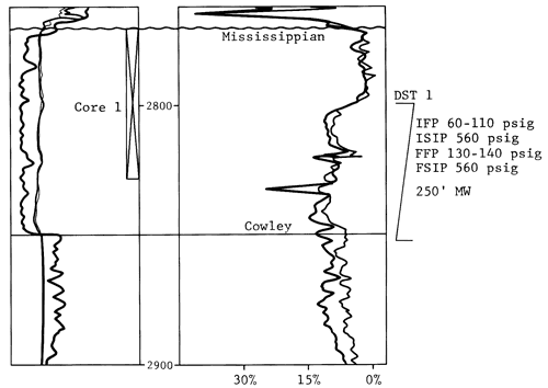
Figure 4--Facies distribution of Brandt-Sensenbaugh "pay," Butler County, Kansas.
The pay zone present in the Brandt-Sensenbaugh field is one of a high-energy, well-sorted biosparite. Secondary dolomite has selectively replaced portions of the sparry calcite cement. The above-mentioned diagenesis is limited, as primary intercrystalline porosity is preserved, accounting for the large majority of the total effective porosity.
The biohermal depositional environment suggested by the core analysis is lenticular and arcuate shaped. A cursory analysis of the underlying Arbuckle formation shows a pronounced structural high coincident with the Mississippian-producing trend. Hence, the underlying structure has controlled the geometry and development of the Mississippian porosity. This structural influence is evident as downdip tests exhibit lower-energy facies consisting of mudsupported, poorly sorted biomicrites. There is a lack of deeper tests in the northern portions of the field, therefore the degree of Arbuckle-influenced structure is not known in the immediate core area. It is unclear as to why the Arbuckle structure is arcuate.
Kansas Geological Survey
Comments to webadmin@kgs.ku.edu
Web version April 13, 2010. Original publication date 1985.
URL=http://www.kgs.ku.edu/Publications/Bulletins/Sub6/Coffey/index.html