Kansas Geological Survey, Subsurface Geology 12, p. 37-39
by
A. Simo
University of Wisconsin
Studies of carbonate sediments suggest that the most important factors controlling the growth of platforms are eustatic sea-level variations, thermal and flexural subsidence, and changes in sediment-accumulation rates. These factors are interdependent, and they combine in a complex manner to determine the platform geometry. Computer simulation integrating these three factors is very helpful to understand the interplay of the different processes and the resulting geometry. One of the constraints of computer simulation is that the independent variables of eustasy, subsidence, and accumulation rates are not well known in the geologic record. In many cases the variables are synthetic or are calibrated after Holocene case studies. Carbonate-sediment accumulation rates are probably the most difficult parameter to measure, in part because the Holocene accumulation rates are one order of magnitude higher than ancient rocks (Wilson, 1975). Independent measurements of eustasy and subsidence for a given example are obtained using standard facies analysis (flooded in contrast to subaerially exposed platform top) and backstripping techniques. The objective of this paper is to describe a method to quantify two-dimensional sediment-accumulation rates on carbonate platforms, and to tabulate measurement for different ancient platforms. The method integrates vertical aggradation and lateral progradation of carbonate platforms, and the results can be applied to constrain the magnitude of sediment-accumulation rates used in computer simulation. This is a progress report, and refinement of the method and acquisition of data are needed.
Carbonate platforms, when under favorable conditions, aggrade vertically and prograde basinward, filling some or most of the accommodation space available. In general these two directions of platform growth are expressed in Bubnoff units (m/Ma or mm/ka) by two linear measurements: sediment-accumulation rates (a vertical measurement-length of section by the time required for it to accumulate), and progradation rates (a horizontal measurement--distance from an older shelf edge to a younger shelf edge by the time needed for it to prograde). Sediment accumulation and progradation rates are different from sedimentation rates because they include times of deposition and nondeposition (see discussion of stratigraphy completeness, Dott, 1988). Difficulties in quantifying sediment accumulation and progradation rates come from uncertainties in the biostratigraphic time scale, and in the amount of compaction and diagenetic changes. The basic idea in this paper is to combine the vertical and horizontal linear measurements and obtain a cross sectional area of a platform for a given time interval. The measurement of the area can be attained using different techniques (planimeter, image analysis) directly from reconstructed stratigraphic cross section or seismic lines. The cross sectional area can be converted to an average sediment thickness if the progradation is known, and vice versa. The selection of the time interval is highly dependent of each individual cross section and basin geometry. I suggest the use of unconformities, sequence boundaries, or regional sharp-facies changes to delineate the different sedimentary packages to be measured. Sediment-accumulation rates in this paper are defined as the cross sectional area divided by the time interval required for it to accumulate. This two-dimensional sediment-accumulation rate method averages the sediment-accumulation rates of different depositional facies existing on the platform and averages die effects of preexisting topography. The two-dimensional accumulation rates obtained by this method are different from the carbonate platform growth-potential concept (Schlager, 198 1). The platform-growth potential (at least 400500 Bubnoffs; Schlager, 1989, personal communication) centers on the potential of platform rims to growth at "full speed" at certain times to "catch up" with an increasing vertical accommodation space. The major problem with this areal method is to quantify offbank-sediment dispersal. In the examples studied, I excluded detrital and pelagic sedimentary wedges (few meters thick), but I did not exclude cases where small amounts of detrital and pelagic grains are well mixed with carbonate sediments. Particular care was taken in confining the boundary between foreslope and basin facies. Foreslope facies includes all the rocks with "in situ" relatively shallow-water sediments and deeper sediment with boulder- to sand-size carbonate clasts and grains derived from shallow water.
Preliminary data (fig. 1, table 1) suggest variations of areal-accumulation rates of 2-10 km2 (0.8-4 mi2)/Ma. Higher accumulation rates occur when the carbonate platforms show high progradation but slow aggradation rates. Lower accumulation rates occur when carbonate platforms show high aggradation but slow progradational rates. A crossplot of linear- and areal-accumulation rates (fig. 1) shows three fields characterized by A) low linear-accumulation rates (under 200 m [660 ft]/Ma) and low areal-accumulation rates (under 5 km2 [2 mi2]/Ma), B) high linear-accumulation rates (200-600 m [660-1968 ft]/Ma) and low areal-accumulation rates (under 5 km2 [2 mi2]/Ma), and C) low linear-accumulation rates (under 200 m/Ma) and high areal-accumulation rates (5-10 km2 [2-4 mi2]/Ma). Linear-accumulation rates were measured in the thickest part of the platform. Errors incorporated in the calculations include biostratigraphic uncertainties, compaction, diagenesis, and accuracy of each cross section analyzed.
This preliminary data suggest that the accommodation space (e.g., relative sea-level changes, inherited topographic relief, water depth) is a very important factor in controlling carbonate-platform geometry (fig. 1), assuming an optimal biota-growth potential. However, environmental factors such as inimical bank water, nutrients, climate, and waves are also critical in controlling the type (fig. 1) and geometry of the carbonate platforms.
Figure 1--Cross plot of unear versus areal accumulaiton rates; data from Table 1.
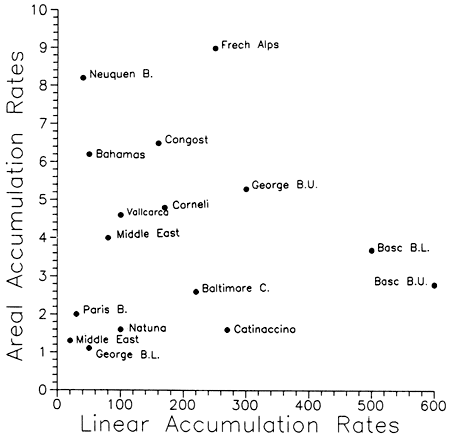
Table 1--Accumulation rates of Cenozoic and Mesozoic carbonate platforms.
| Time | Platform | Linear Rate mm/Ka |
Areal Rate sq Km/Ma |
Observation | Source |
|---|---|---|---|---|---|
| Upper Miocene-Pliocene | Bahamas | 50 | 6.2 | prograding rimmed platform | Eberh & Ginsburg (1989) |
| Middle-Upper Miocene | Natuna platform, South China Sea | 100 | 1.6 | backstepping isolated platform | Rudolph & Lehmann (1989) |
| Campanian | Vallcarca, Southern Pyrenees | 100 | 4.6 | prograding skeletal-rich platform | Simo (1989) |
| Santonian | Sant Cornelli, Southern Pyrenees | 170 | 4.8 | prograding skeletal-rich platform | Simo (1989) |
| Coniacian Turonian | Congost, Southern Pyrenees | 160 | 6.5 | prograding skeltal-rich platform | Simo (1989) |
| Lower Albian | Basc basin Upper platform |
600 | 2.8 | isolated platform, with deep lagoon | Fernandez-Mendiola (1987) |
| Lower platform | 500 | 3.7 | isolated platform ramp | ||
| Barremian-Bedoulian | French Alps | 250 | 9 | prograding platform with outer-shelf | Amaud (1984) |
| Barremian | Middle East | 20 | 1.3 | low-energy ramp | Morris (1980) |
| Tithonian-Valanginian | Neuquen basin | 40 | 8.2 | prograding platform with delta-plain facies | Mitchum & Uhana (1985) |
| Tithonian | Middle East | 80 | 4 | rimmed prograding platform, with evaporitic lagoon | Morris (1980) |
| Tithonian | Baltimore Canyon U.S. Atlantic coast | 220 | 2.6 | rimmed prograding platform with delta-plain facies | Earlich et al. (1988) |
| Bathonian | Paris basin | 30 | 2 | oolitic platform | Dubois & Yapaudjian (1985) |
| Upper Jurassic | George Bank, U.S. Atlantic coast | 300 | 5.3 | prograding rimmed platform with delta plain | Poag (1982) |
| Lower-Middle Jurassic | George Bank, U.S. Atlantic coast | 50 | 1 | prograding rimmed platform with delta plain | Poag (1982) |
| Ladinian, Triassic | Catinaccino platform, Southern Alps | 270 | 1.6 | isolated prograding platform | Bosellini & Doglioni (1988) |
Arnaud, H., 1984, Observation of outcrops at a seismic scale in view of seismic stratigraphic interpretation: American Association of Petroleum Geologists, Mediterranean Basins Conference, Field-trip guidebook 2, I-V (unpublished Ph.D. thesis mentioned in Ravenne C. and R. Vially, 1988)
Bosellini, A., and Doglioni, C., 1988, Progradation geometries of Triassic carbonate platforms of the dolomites and their large-scale physical stratigraphy: American Association of Petroleum Geologists, Mediterranean Basins Conference, Field-trip guidebook 6, 42 p.
Dott, R. H., Jr., 1988, Perspectives--something old, something new, something borrowed, something blue--a hindsight and foresight of sedimentary geology: Journal of Sedimentary Petrology, v. 58, p. 358-364
Dubois, P., and Yapaudjian, L., 1985, Le Jurassique: BRGM Synthese Geologique du Bassin de Paris, 340 p.
Eberh, G. P., and Ginsburg, R. N., 1989, Cenozoic progradation of northwestern Great Bahama Bank, a record of lateral platform growth and sea-level fluctuation: Society of Economic Paleontologists and Mineralogists, Special Publication 44, p. 339-351
Earlich, R. N., Maher, K. P., Hummel, G. A., Benson, D. G., Kastritis, G. J., Linder, H. D., Hoar, R. S., and Neeley, D. H., 1988, Baltimore Canyon trough, Mid-Atlantic OCS--seismic stratigraphy of Shell/Amoco/Sun wells: American Association of Petroleum Geologists, Studies in Geology, no. 27, v. 2, p. 51-66
Fernandez-Mendiola, P. A., 1987, El Compleji Urgoniano en el sector oriental del antichnorio de Bilbao: KOBIE, v. 16, 184 p-
Mitchum , R. M., Jr., and Uliana, M. A., 1985, Seismic stratigraphy of carbonate depositional sequences, Upper Jurassic-Lower Cretaceous, Neuquen basin, Argentina: American Association of Petroleum Geologists, Memoir 39, p. 255-274
Morris, R. J., 1980, Middle East: stratigraphic evolution and oil habitat: American Association of Petroleum Geologists, Bulletin, v. 64, p. 597-618
Poag, C.W., 1982, Stratigraphic reference section for Georges Bank basin--depostional model for New England passive margin: American Association of Petroleum Geologists, Bulletin, v. 66, p. 1,021-1,041.
Rudolph, K. W., and Lehmann, P. J., 1989, Platform evolution and sequence stratigraphy of the Natuna platform, South China Sea; in, Controls on Carbonate Platform and Basin Development, P. D. Crevello, J. L. Wilson, J. F. Sarg, and J. F. Read (eds.): Society of Economic Paleontologists and Mineralogists, Special Publication 44, p. 353-361
Schlager, W., 1981, The paradox of drowned reefs and carbonate platforms: Geological Society of America, Bulletin, v. 92, p. 197-211
Simo, A., 1989, Upper Cretaceous platform-to-basin depositional-sequence development, Tremp basin, south-central Pyrenees, Spain; in, Controls on Carbonate Platform and Basin Development, P. D. Crevello, J. L. Wilson, J. F. Sarg, and J. F. Read (eds.): Society of Economic Paleontologists and Mineralogists, Special Publication 44, p. 365-378
Wilson, J. L., 1975, Carbonate facies in geologic history: Springer-Verlag, 471 p.
Kansas Geological Survey
Comments to webadmin@kgs.ku.edu
Web version May 11, 2010. Original publication date 1989.
URL=http://www.kgs.ku.edu/Publications/Bulletins/Sub12/Simo/index.html