
Previous--Selected Pleistocene Exposures || Next--Paleontological Considerations
Buried Valleys in the Lower Part of the Missouri River Basin
by Vincent H. Dreeszen and Raymond R. Burchett
Conservation and Survey Division, University of Nebraska, Lincoln, Nebraska
Continental ice sheets, streams, and wind combined forces during the Pleistocene to reshape the land surface in the lower part of the Missouri River Basin. Prior to glaciation a drainage system largely unrelated to the river system now draining the area had developed on the bedrock surface. Although parts of this surface were modified repeatedly during the Pleistocene, most of the buried valley system probably developed during the late Tertiary and early Pleistocene. Some segments of bedrock valleys may be much older; e.g., the valley now occupied by the Platte River in Nebraska from Ashland to its mouth at Plattsmouth is believed to have been trenched first by west-flowing drainage during the Cretaceous (Dakota). Glacial, alluvial, and eolian deposits now mantle much of the bedrock topography and fill many of the old valleys to depths ranging up to several hundred feet. The depositional sequence-particularly of Nebraskan and Kansan age-is discontinuous and often masked by loess and alluvial deposits of Illinoian and Wisconsinan age. Definition of the system of buried valleys is basic to correlation of deposits filling them and is basic also to an understanding of the age and sequence of events that produced trenching and gave rise to the systems of past and present major valleys.
The drainage history of the area, the pattern of occurrence and nature of the buried bedrock, and the stratigraphic succession of the Pleistocene deposits have been subjects of study and speculation for many years. Exploratory test drilling by public and private interests for water, limestone, oil and gas, sand and gravel, and engineering data have increased significantly the geologic- and economic-resource knowledge gained from a long history of surface study in the lower Missouri River Basin. The state geological surveys, individually and in cooperation with federal and other state agencies, have investigated much of the area with systematic test drilling. The results of most of these investigations have been published in interpretive reports that include bedrock topographic maps.
A bedrock topographic map of northwestern Missouri was prepared by Heim and Howe (1962) and a comprehensive review of the Pleistocene history of the area was presented by Heim and Howe (1963). The bedrock topography of southwestern Iowa was mapped and discussed by Hershey, Brown, Van Eck, and Northrup (1960), Sendlein, Henkel, and Hussey (1968) and Sendlein and Henkel (1970). Cagle and Steinhilber (1967) and Cagle (1969) mapped the bedrock surface in south-central Iowa. The Kansas Geological Survey has published a series of county and regional reports relating to the glacial geology and occurrence of buried valleys in northeastern Kansas. A map showing the bedrock topography in northern Kansas and southern and eastern Nebraska is presented in Reed, Dreeszen, Bayne, and Schultz (1965). Burchett and Dreeszen (in Burchett and Carlson, 1966) mapped the configuration of the bedrock surface in southeastern Nebraska and Burchett (1970) depicted the trend of bedrock valleys in that area and the adjacent parts of Iowa and Missouri.
Sufficient surface and subsurface data were available to permit these various workers to map the bedrock surface at 50-foot contour intervals. Alternative interpretations of buried valley trends can be made in some places where control is limited. For example, only limited systematic subsurface investigation has been done in the Missouri River valley.
The authors utilized published bedrock topographic maps to infer the probable preglacial drainage (Fig. 1, p. 24-25) in the lower Missouri River Basin where the four states of Iowa, Kansas, Missouri, and Nebraska adjoin. Also utilized was an unpublished bedrock topographic map of northeastern Kansas contributed by Charles K. Bayne and Howard G. O'Connor of the Kansas Geological Survey. Supplemental data for southern Iowa were provided by Orville Van Eck of the Iowa Geological Survey and Joseph Cagle of the U.S. Geological Survey at Iowa City. Wallace B. Howe of the Missouri Geological Survey and Stanley N. Davis of the University of Missouri at Columbia, together with Charles Bayne and Howard O'Connor of the Kansas Geological Survey, reviewed a first draft of the map and offered suggestions but had no opportunity to review the final map.
Figure 1--Preglacial drainage map of the lower Missouri Basin.
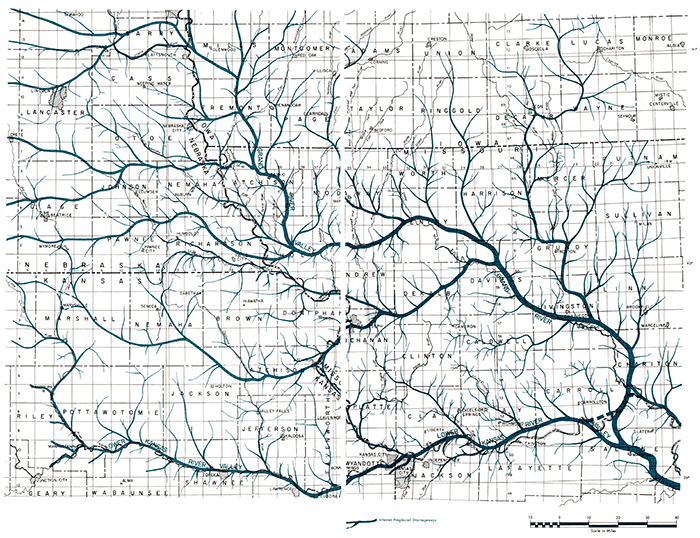
Heim and Howe (1963) applied the names of modem rivers to buried valleys in northwestern Missouri where they deemed it possible. For those valleys that were not indicated to be related to the modern drainage system, they selected place names. Their name--Grand River Valley, after the Grand River in Missouri--has been used in Iowa by Sendlein, Henkel, and Hussey (1968) for the extension of that buried valley into Iowa. The authors accept that name in this report if for no other reason than that the "Grand River Valley" appears to be the "grand" valley of the system. The practice of applying the names of modern rivers to major buried valleys seems to be questionable because the relation of buried valleys to modern streams is generally only coincidental. Place names or other descriptive names for major buried valleys and for segments of buried valleys would seem preferable. The name Lower Kansas River Valley was applied by Heim and Howe (1963) to the buried valley from Kansas City east to the Grand River Valley. That name is also applied in this report to the segment approximately coincident with the Kansas River in Kansas.
Dominant features on the map are: the Grand River Valley and the Lower Kansas River Valley of Heim and Howe (1963); the present Big and Little Blue River valleys in Kansas; the several west-to-east major tributary valleys which cross the Missouri River valley and enter the Grand River Valley from the west; and several south-trending tributary valleys which enter the Grand River Valley from the north. Each of these 'buried" valleys, with two possible exceptions, is believed to have developed prior to and during early Pleistocene time. The exceptions are the Big and Little Blue River valleys in the Kansas portion of the area, which may have developed as ice-marginal valleys in early Kansan time. The drainageway from below Atchison, Kansas, to Kansas City is probably an ancient major tributary to the Lower Kansas River Valley that now is occupied by the Missouri River.
At this time we can only speculate in regard to the northward extension of the Grand River Valley into Iowa and Nebraska. Sendlein et al. (1968) and Sendlein and Henkel (1970) mapped the buried valley extension of the Grand River Valley system approximately no miles north into Iowa from the Iowa-Missouri border. Although the evidence is not complete it appears that two major buried valleys join the Grand River Valley in south-central Mills County, Iowa, with one branch continuing on north into Iowa and the other branching to the northwest into Nebraska. Two other major tributaries that have been mapped into central Nebraska join this branch south of Omaha and near Plattsmouth, Nebraska. However, the main buried valley continues many miles northwestward into the Elkhorn River Basin, which is outside the map area. Possibly a major tributary or even the main valley of the Grand River system extends northward coincident with the Missouri River valley. Although bedrock control is inadequate to support this conjecture, one line of evidence--the broadening of the Missouri River valley a few miles north of Omaha, Nebraska, and Council Bluffs, Iowa--does support this possibility. The great width of the valley of the Missouri River in this area is due primarily to, but is not explained fully by, the less resistant nature of the bedrock (Cretaceous sandstone and shale and Pennsylvanian shale and thin limestones) than that in the area to the south. Todd (1898) suggested the relation of valley width to the character of the bedrock in an interesting discussion on the ages of the terraces and trough of the Missouri River.
The buried valleys shown in southeastern Nebraska have been traced westward more than halfway across the state and, presumably, are a part of the Rocky Mountain drainage system. For example, the most southerly of these buried valleys (at various times mistakenly referred to as the "Ancestral Republican River") extends upgradient into Kansas near Chester, Nebraska, and back into Nebraska near Superior. For 15 miles westward from Superior this "buried" valley is coincident with the present Republican River valley and then branches. One branch has been mapped to the northwest and the other is approximately coincident with the present Republican River valley.
Some major and tributary preglacial valleys retain, at least in part, their original valley fills of early to medial Pleistocene age, whereas other of these valleys were reopened, deepened, and subsequently refilled. Both the buried and the modern drainage systems are composite. Generally, modern valleys are wider where they cross buried drainageways. Several examples of this can be seen on soils and topographic maps along the Missouri River between Plattsmouth, Nebraska, and St. Joseph, Missouri. Also, where present rivers have occupied segments of partly filled "buried" valleys, the modern valley tends to be wider than might normally be expected. Examples of such rivers, referred to as "misfit" rivers, are the present Thompson River and the Gallatin-Chillicothe segment of the present Grand River (Heim and Howe, 1963) in northwestern Missouri. The major example of coincidence of modern streams and a major preglacial valley is the Kansas River from Manhattan, Kansas, to Kansas City and the Missouri River eastwardly from Kansas City. An interesting example of a major tributary "buried" valley that probably has been almost completely exhumed is the Nemaha River in extreme southeastern Nebraska. The authors speculate that this buried valley is the northwestward extension of the buried valley north of st. Joseph, Missouri-the Amazonia Valley of Heim and Howe (1963).
The direction of movement and extent of continental ice sheets were controlled in part by the slope and configuration of the land surface over which they rode. Definition of the surface overridden by each advancing ice sheet will be difficult to accomplish but should be attempted if we are to understand more fully the succession of deposits left by, or derived from, the glaciers. Possibly the surface least difficult to define will be the bedrock surface prior to glaciation.
Selected References
Burchett, R. R., 1965, Correlation of the formations drilled in test holes for Interstate 480 Bridge between Omaha, Nebraska and Council Bluffs, Iowa: Nebraska Geol. Survey Paper 17, 30 p.
Burchett, R. R., (Compiler), 1969, Geologic bedrock map of Nebraska: Nebraska Geol. Survey: Scale 1: 1,000,000.
Burchett, R. R., 1970, Guidebook to the geology along the Missouri River bluffs of southeastern Nebraska and adjacent areas: Nebraska Geol. Survey Guidebook, 21 p.
Burchett, R. R., and Carlson, M. P., 1966, Twelve maps summarizing the geologic framework of southeastern Nebraska: Nebraska Geol. Survey, Rept. Inv. 1, 14 p.
Burchett, R. R., and Reed, E. C., 1967, Centennial guidebook to the geology of southeastern Nebraska: Nebraska Geol. Survey Guidebook, 83 p.
Cagle, J. W., 1969, Availability of ground water in Wayne County, Iowa: Iowa Geol. Survey Water Atlas 3, 33 p.
Cagle, J. W., and Steinhilber, W. L., 1967, Availability of ground water in Decatur County, Iowa: Iowa Geol. Survey Water Atlas 2, 28 p.
Frye, John C., and Walters, K. L., 1950, Subsurface reconnaissance of glacial deposits in northeastern Kansas: Kansas Geol. Survey Bull. 86, pt. 6, p. 143-158. [available online]
Heim, George E., and Howe, Wallace B., 1962, Map of the bedrock topography of northwestern Missouri: Missouri Geol. Survey and Water Resources: Scale 1:250,000.
Heim, George E., and Howe, Wallace B., 1963, Pleistocene drainage and depositional history in northwestern Missouri: Trans. Kansas Acad. Sci., v. 66, no. 3, p. 378-391.
Hershey, H. G., Brown, C. N., Van Eck, O., and Northrup, R. C., 1960, Highway construction materials from the consolidated rocks of southwestern Iowa: Iowa Highway Research Board Bull. 15, 151 p.
Horberg, Leland, 1950, Bedrock topography of Illinois: Illinois Geol. Survey Bull. 73, 111 p.
Iowa Geological Survey, 1969, Geologic map of Iowa: Scale 1:500,000.Kansas Geological Survey, 1964, Geologic map of Kansas: M-1, scale 1:500,000.
McCracken, Mary H., (Compiler), 1961, Geologic map of Missouri: Missouri Geol. Survey and Water Resources: Scale 1: 500,000.
Reed, E. C., Dreeszen, V. H., Bayne, C. K., and Schultz, C. B., 1965, The Pleistocene in Nebraska and northern Kansas; in, The Quaternary of the United States, H. E. Wright, Jr. and D. G. Frey, eds.: Princeton Univ. Press, p. 187-202.
Sendlein, Lyle V. A., and Henkel, Donald E., 1970, [abs.] Preglacial bedrock topography of southwestern Iowa: Geol. Soc. America, Abstracts with Programs, v. 2, no. 6, p. 405.
Sendlein, Lyle V. A., Henkel, Donald E., and Hussey, Keith M., 1968, Geology of the Regolith Aquifers of the Nishnabotna Basin: Dept. of Earth Science Completion Report Project No. A-012-1A, 29 p.
Todd, J. E., 1898, The moraines of southeastern South Dakota and their attendant deposits: U.S. Geol. Survey Bull. 158, 171 p.
Previous--Selected Pleistocene Exposures || Next--Paleontological Considerations