Kansas Geological Survey, Irrigation Series 5, originally published in 1979
Previous Page--Report Start
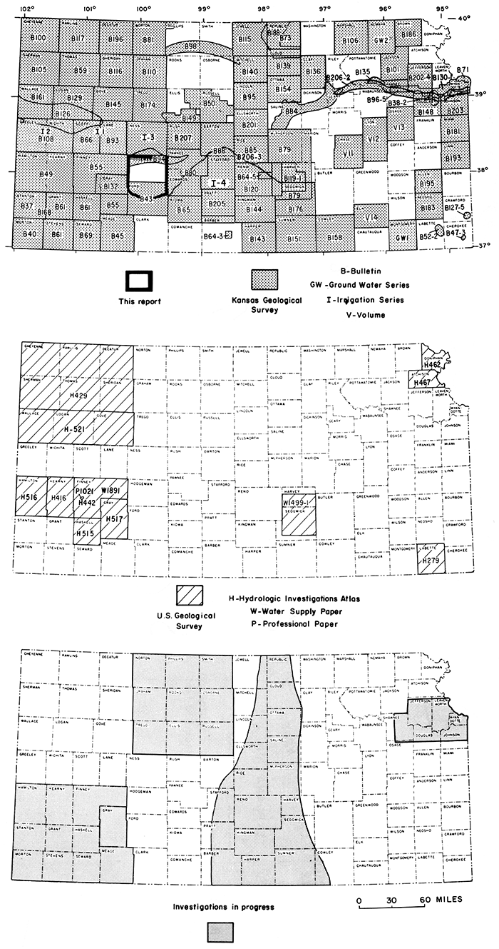
This investigation is a part of a continuing study of the ground-water resources of Kansas that began in 1937. The cooperative program is being conducted by the Kansas Geological Survey and the U.S. Geological Survey, with the support of the Division of Water Resources, Kansas State Board of Agriculture, and the Division of Environment, Kansas Department of Health and Environment. The present status of the ground-water investigations in Kansas is shown in figure 12. The numbers and letters on the map refer to reports published by the Kansas Geological Survey and to reports published by the U.S. Geological Survey.
Figure 12--Area described in this report and other areas for which reports are available or are in preparation.
The hydrographs of 24 observation wells in the Dakota Formation (fig. 13) show the water-level changes in selected wells in Hodgeman and northern Ford Counties (locations shown in figure 7). These hydrographs illustrate the different seasonal fluctuations resulting from ground-water withdrawals in areas of confined and unconfined aquifer conditions and the gradual long-term water-level declines owing to the reduction in ground-water storage.
Figure 13--Hydrographs for selected wells in Dakota Formation.
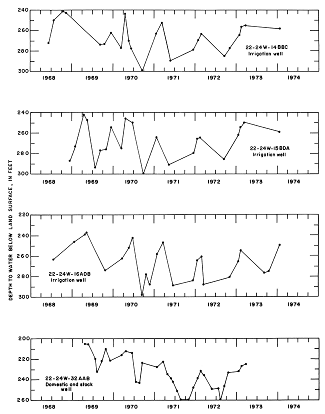
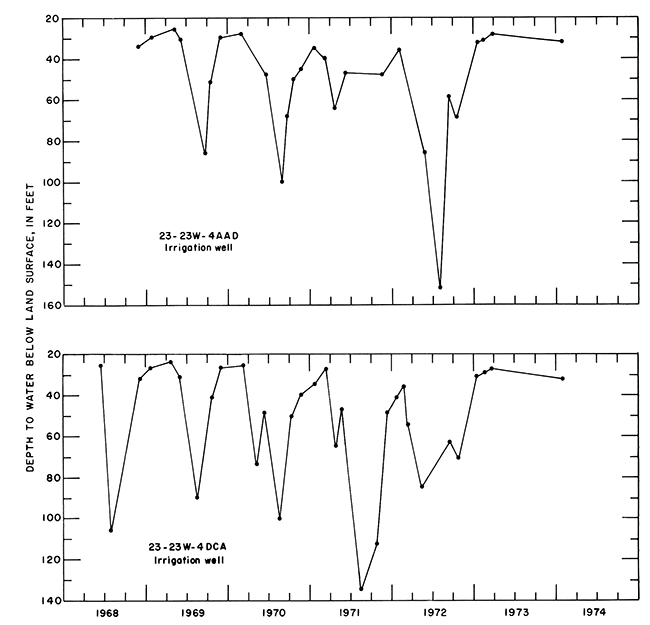
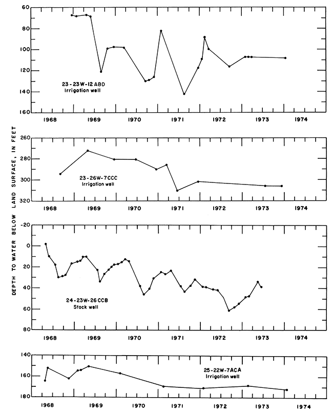
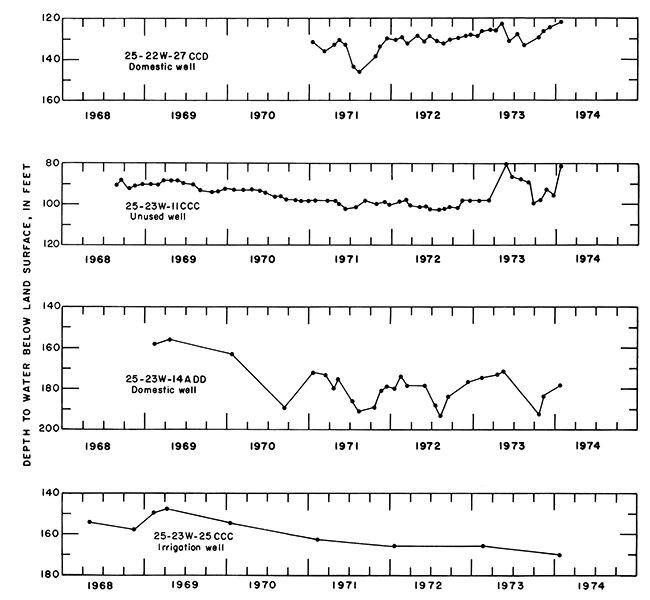
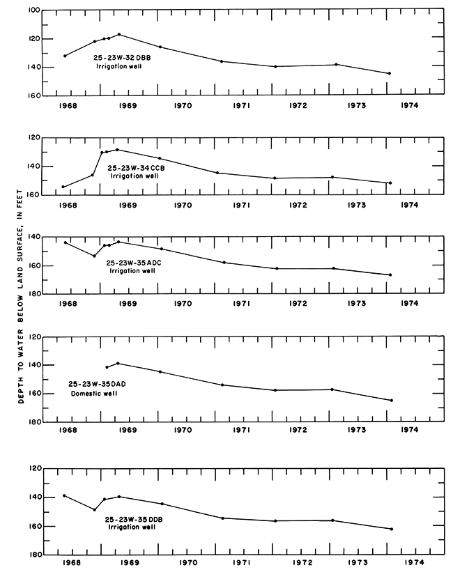
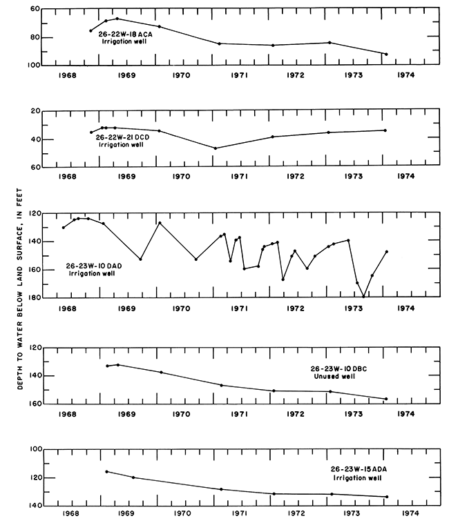
Table 4 lists the records of 94 selected wells that obtain most or all of their water supply from the Dakota Formation. Listed are records of 62 irrigation wells, 5 public-supply wells, 20 domestic wells, and 7 unused wells where water levels are measured.
Table 4--Records of selected wells.
| Well number (1) |
Owner or user | Year completed |
Depth of well (ft) (2) |
Diameter of casing (in) |
Method of lift and type of power (3) |
Use (4) |
Yield gal/min) (5) |
Specific capacity | Altitude of land surface above mean sea level (ft) (7) |
Depth to water below lsd (ft) (8) |
Date of measurement (9) |
Acres irrigated |
Power consumption per acre-ft |
|||
|---|---|---|---|---|---|---|---|---|---|---|---|---|---|---|---|---|
| Gal/min/ft dd (6) |
Hrs | Kwh (10) |
Ft2 ng/l00 |
Gal diesel fuel |
||||||||||||
| Hodgeman County | ||||||||||||||||
| 21-21W-31DDA | Jim Wright | 1947 | 360 R | CY,W | S | 290. | 6/1972 | |||||||||
| 21-22W-27CB | Claude Selfridge | 1945 | 287 R | D,S | 180. | 5/1972 | ||||||||||
| 21-23W- 3CDB | R. G. Frusher | 1961 | 400 R | D | 200. | 6/1972 | ||||||||||
| 21-24W-27BCC | Roy Croft | 1956 | 330 R | D,S | 80. | 5/1972 | ||||||||||
| 21-26W-16BBA | Merle Evans | 368 R | 6 | S | 200. | 5/1969 | ||||||||||
| 22-22W-19ABB | Ethel Oppy | 228 R | S | 208. | 5/1972 | |||||||||||
| 22-24W-14BBC | Clare Shriwise | 560 R | 16 | T,NG | I,O | 850 | 5 | 960 | 2,460 | 255. | 3/1973 | 500 | 89 | |||
| 22-24W-15BDA | William McKibben | 585 R | 12 | T,NG | I,O | 1,300 | 7 | 312 | 2,463 | 250. | 3/1973 | 400 | 117 | |||
| 22-24W-16ACC | Wayne Shriwise | 365 R | 6 | CY,W | D | 2,470 | 262. | 6/1973 | ||||||||
| 22-24W-16ADB | Wayne Shriwise | 565 R | 16 | T,NG | I,O | 560 | 6 | 960 | 2,465 | 245. | 5/1973 | 110 | 138 | |||
| 22-24W-16ADB2 | Wayne Shriwise | 1972 | 565 | 1 | N | O | 2,465 | 243. | 5/1973 | |||||||
| 22-24W-24DDC | Bernard Springer | 1960 | 430 R | D,S | 90. | 5/1972 | ||||||||||
| 22-24 W -32AAB | Mrs. Wilbur Walter | 340 R | 6 | D,S,O | 2,454 | 226. | 3/1973 | |||||||||
| 22-24W-34CDD | Cecil Shelton | 1966 | 390 R | D,S | 80. | 5/1969 | ||||||||||
| 22-26W-23DCC | L. L. Glunt | 505 R | S | |||||||||||||
| 23-22W-7DAA | Fred Korf | 72 | 482 R | 1 | O | 2,239 | 86. | 5/1973 | ||||||||
| 23-22W-29DDD | Frank Sebes | 350 R | S | 40. | 5/1972 | |||||||||||
| 23-23W-3CBD | Quinton Hubin | 1969 | 257 R | 16 | T,E | I | 300 | 2,222 | 27. | 2/1973 | 50 | 481 | ||||
| 23-23W-4AAD | 3 J Ranch | 1968 | 282 R | 16 | T,D | I,O | 290 | 2 | 960 | 2,235 | 38. | 4/1973 | 59 | |||
| 23-23W-4DCA | L. G. Hoagland | 260 R | 16 | T,LPG | I,O | 760 | 4 | 312 | 2,230 | 27. | 3/1973 | 130 | ||||
| 23-23W-6CAB | City of Jetmore | 385 R | 16 | T,E | PS | 2,263 | ||||||||||
| 23-23W-9BBD | 3 J Ranch | 290 R | 16 | T,D | I,O | 440 | 2,254 | 125 | ||||||||
| 23-23W -12ABD | 3 J Ranch | 1968 | 245 R | 14 | T,D | I,O | 330 | 107. | 3/1973 | 110 | ||||||
| 23-23W-12BCC | 3 J Ranch | 1970 | 265 R | 16 | T,LPG | I | 300 | 2,260 | 125. | 2/1973 | 30 | |||||
| 23-23W-12CAC | 3 J Ranch | 1968 | 256 R | 12 | SUB,E | I | 130 | 6 | 552 | 2,280 | 147. | 2/1973 | ||||
| 23-23W-12DDB | 3 J Ranch | 1970 | 275 R | 16 | T,D | I | 200 | 2,302 | 165. | 2/1973 | 135 | |||||
| 23-23W-15DAB | State of Kansas | SUB,E | PS | |||||||||||||
| 23-23W-21AAC | 3 J Ranch | 1972 | 395 R | 15 | T,D | I | 660 | 4 | 960 | 130 | ||||||
| 23-24W-1AAC | City of Jetmore | 395 R | 16 | T,E | PS | 2,315 | ||||||||||
| 23-24W-1C | City of Jetmore | 16 | T,E | PS | ||||||||||||
| 23-24W-28BCC | Heating/Cooling Inc. | 1972 | 570 R | 1 | O | 2,481 | 213 R | 3/1973 | ||||||||
| 23-25W-7B | Ray Wilson | 1964 | 505 R | D,S | 220. | 6/1972 | ||||||||||
| 23-25W-11ADA | Roy Carder | 200 R | 6 | D,S | 80. | 5/1969 | ||||||||||
| 23-25W-22DBB | Roy Carder | 575 R | 16 | T,D | I | 1,030 | 8 | 984 | 2,522 | 233. | 5/1973 | 196 | 34 | |||
| 23-26W-7CCC | Harry Cohoon | 490 R | 16 | T,D | I,O | 1,150 | 12 | 600 | 2,612 | 306. | 7/1973 | 210 | 31 | |||
| 24-21W-30ABB | Vernon Katz | 250 R | 16 | T,E | I | 180 | 2,341 | |||||||||
| 24-21 W-30ABC | Vernon Katz | 250 R | 16 | T,E | I | 150 | 2,341 | |||||||||
| 24-23W-6AAB | Frank Wolf | 517 R | 16 | T,D | I | 750 | 5 | 960 | 2,457 | 227. | 5/1973 | 150 | ||||
| 24-23W-22B | Raymond Fagan | 200 R | D | |||||||||||||
| 24-23W-26CCB | Russell Beil | 117 R | 2 | CY,W | S,O | 2,299 | 33. | 5/1973 | ||||||||
| Ford County | ||||||||||||||||
| 25-21W-18CCD | Kermit Froetschner | T,E | I | 130 | 2,384 | 23 | ||||||||||
| 25-21W-23BCB | Gail Hubbell | 1969 | 127 R | 16 | T,E | I,O | 1,040 | 2,311 | 63. | 3/1973 | 140 | |||||
| 25-22W-7ACA | Kermit Froetschner | 1968 | 350 R | 16 | T,D | I,O | 750 | 7 | 960 | 2,441 | 164. | 5/1973 | 160 | 30 | ||
| 25-22W-27CCD | James Nietling | 240 R | CY,W | D,O | 2,432. | 123. | 5/1973 | |||||||||
| 25-22W-30DCC | City of Spearville | 16 | T,E | PS | ||||||||||||
| 25-22W-34DDB | Norbert Tasset | 1973 | 410 R | 14 | T,D | I | 460 R | 2,423 | 120 | |||||||
| 25-23W-11CCC | KGS + USGS | 1968 | 385 | 1 | N | 0 | 2,424 | 75. | 5/1973 | |||||||
| 25-23W-128BB | KGS + USGS | 1972 | 362 | 1 | N | 0 | 2,390 | 117. | 5/1973 | |||||||
| 25-23W-14ADD | T. Gleason | 263 R | 5 | D,S,O | 2,452 | 171. | 5/1973 | |||||||||
| 25-23W-25CCC | Donald Stein | 372 R | 16 | T,D | I,O | 1,280 | 9 | 912 | 2,463 | 166. | 2/1973 | 160 | ||||
| 25-23W-32DBB | Tom Feist | 1968 | 380 R | 16 | T,D | I,O | 520 | 2 | 912 | 2,463 | 150. | 5/1973 | 230 | |||
| 25-23W-34CCB | Bernard Knoeber | 1967 | 350 R | 16 | T,D | I,O | 810 | 2,461 | 160 | |||||||
| 25-23W-35ADC | Wendeline Stegman | 1967 | 360 R | 16 | T,D | I,O | 1,200 | 17 | 960 | 2,461 | 163. | 2/1973 | 160 | |||
| 25-23W-3SDAD | Melvin J. Stein | 310 R | D,O | 2,456. | 158. | 2/1973 | ||||||||||
| 2S-23W-3SDDB | Melvin J. Stein | 300 R | 16 | T,D | I,O | 1,280 | 2,457 | 157. | 2/1973 | 160 | ||||||
| 25-23W-36BDA | Josephine Stein | 380 R | 16 | T,D | I | 1,200 | 22 | 696 | 2,466 | 170 R | 3/1973 | 180 | 32 | |||
| 26-21W-1ACA | Jack Kersting | 1968 | 165 R | 16 | T,E | I | 740 | 2,264 | 20. | 5/1973 | 34 | |||||
| 26-21W-1BCA | Jack Kersting | 135 R | 16 | T,E | I | 750 | 2,263 | 50 | ||||||||
| 26-21W-11CBD | H. W. Wetzel | 1967 | 174 R | 16 | T,D | I,O | 770 | 2,280 | 22.0 | 5/1973 | 100 | |||||
| 26-21W-13BD | H. C. Wetzel | 25 R | D,S | |||||||||||||
| 26-21W-17DBC | Larry Strong | 1973 | 12 | O | 2,348 | 49.1 | 5/1973 | |||||||||
| 26-22W-5CBA | D. D. Imel | 1973 | 435 R | 16 | T,D | I | 150 | 2,435 | 110 | |||||||
| 26-22W- 6BCD | James Knoeber | 350 R | 16 | T,D | I | 430 | 2,431. | 180 | 26 | |||||||
| 26-22W-6CCA | Melvin Habiger | 1968 | 18 | T,D | I | 2,414 | 98.0 | 5/1973 | 80 | |||||||
| 26-22W-8CAD | American Products | 1973 | 243 R | 16 | T,D | I | 400 R | 2,427 | 135 | |||||||
| 26-22W-8DDC | D. D. Imel | 16 | T,D | I | 510 | 2,434 | 108. | 2/1973 | 83 | |||||||
| 26-22W-11CDC | B. L. Hornung | 154 R | 12 | T,E | I | 380 | 2,356 | 22. | 5/1973 | 50 | ||||||
| 26-22W-18ACA | Ford Co. Bank | 273 R | 16 | T | I,O | 2,404 | 82. | 5/1973 | ||||||||
| 26-22W-21DCD | Norbert Tasset | 1968 | 360 R | 14 | T,D | I,O | 930 | 4 | 504 | 2,377 | 35. | 5/1973 | 180 | 26 | ||
| 26-22W-24AAA | Cletus Heeke | 1968 | 2S0 R | 12 | T,NG | I | 880 | 2,335 | 137 | |||||||
| 26-23W-10DAD | J. A. McGwin | 278 R | 16 | T,E | I,O | 700 R | 7 | 960 | 2,463 | 140. | 5/1973 | 163 | 291 | |||
| 26-23W-10DBC | J. A. McGwin | 280 R | N | O | 2,475. | 151. | 2/1973 | |||||||||
| 26-23W-12BDB | Merle Barnes | T,D | I | 650 | 2,439 | 163 | ||||||||||
| 26-23W-15ADA | William Claussen | 288 R | 16 | T,D | I,O | 700 | 6 | 984 | 2,465 | 128. | 5/1973 | 101 | 28 | |||
| 26-23W-15DCD | William Claussen | 330 R | 16 | T,D | I | 890 | 2,468 | 131 | 25 | |||||||
| 27-21W-29DBB | Albert Miller | 126 R | 12 | T,E | I | 2,318 | 65 | |||||||||
| 27-21W-29DBB2 | Albert Miller | 126 R | 12 | T,E | I | 340 | 2,318 | 65 | ||||||||
| 27-21W-30DDD | Albert Miller | 126 R | 12 | T,E | I | 670 | 2,328 | 65 | 258 | |||||||
| 27-21W-31CBB | Leo Konda | 115 R | 12 | T,D | I | 1,330 | 20 | 312 | 2,335 | 10.0 | 8/1973 | 80 | ||||
| 27-22W-9DAB | Henry Schomaker | 390 R | 16 | T,D | I | 450 | 2,418 | 60 | ||||||||
| 27-22W-13CDD | Henry Schomaker | 1973 | 246 R | 12 | T | I | 1,200 | 2,412 | 23. | 11/1973 | 135 | |||||
| 27-22W-16CCA | Duane Riegel | 240R | 12 | T,E | I | 1,080 | 2,415 | 130 | 244 | |||||||
| 27-22W-19AAC | Ford Land + Cattle | T,E | I | 870 | 2,418 | 135 | 461 | |||||||||
| 27-22W-19DAB | Ford Land + Cattle | T,E | I | 1,130 | 2,417 | 135 | 390 | |||||||||
| 27-22W-20BBD | Ford Land + Cattle | 16 | T,E | I | 1,060 | 2,418 | 135 | 458 | ||||||||
| 27-22W-20CAC | Ford Land + Cattle | 16 | T,E | I | 1,090 | 2,420 | 135 | 461 | ||||||||
| 27-22W-20DAB | Ford Land + Cattle | T,E | I | 1,200 R | 2,415 | 135 | 388 | |||||||||
| 27-22W-20DCD | Ford Land + Cattle | T,E | I | 780 | 2,412 | 135 | ||||||||||
| 27-22W-29BDD | Ford Land + Cattle | 90 R | 16 | T,E | I | 2,403 | ||||||||||
| 27-22W-29CAA | Ford Land + Cattle | 110 R | 16 | T,E | I | 2,405 | ||||||||||
| 27-22W-36AAD | Leo Konda | 115 R | 12 | T,E | I | 560 | 2,341 | 80 | ||||||||
| 27-23W-1SDCB | Francis Ricke | 1970 | 442 R | 12 | T,D | I | 2,200 | 2,399 | 147 | 24 | ||||||
| 27-23W-16BAB | Stanley Kliesen | 1969 | 470 R | 16 | T,D | I | 2,416 | |||||||||
| 27-23W-24BCB | Elmer Riegel | 1972 | 220 R | 16 | T,D | I | 1,550 | 2,395 | 4/1973 | 106 | 14 | |||||
|
(1) Numbering system described in text. (2) Depths of wells given in feet below land surface--no letter after number, measured; R, reported. (3) Method of lift--CY, cylinder; N, none; SUB, submersible; T, turbine. Type of power--D, diesel; E, electric; LPG, liquid petroleum gas; NG, natural gas; W, wind. (4) Use--D, domestic; I, irrigation; O, observation; PS, public supply; S, stock. (5) Yield gal/min, yield given in gallons per minute-s-no letter, measured during present study; R, reported. (6) Specific capacity-gal/min/ft dd, gallons per minute per foot of drawdown for the time shown in hours. (7) Altitude of land surface in feet above mean sea level-measured when followed by decimal point (.); others determined by topographic map or altimeter. (8) Depth to water below land surface datum (lsd) in feet-measured depths less than 100 feet are given to nearest 0.1 foot, and those greater than 100 feet are given to nearest foot followed by decimal point (.); R, reported. (9) Date of water-level measurement-month and year. (10) Power consumption-kwh, kilowatt hours of electricity per acre-foot of water pumped; ft2 ng/l00, hundreds of cubic feet of natural gas per acre-foot of water pumped; gal diesel fuel, gallons of diesel fuel per acre-foot of water pumped. |
||||||||||||||||
Table 5 lists the logs of 14 test holes drilled by the Kansas Geological Survey (locations shown in figure 7). Altitudes are referenced to mean sea level datum and are reported to the nearest foot. Depth of all holes and depth to water in two cased wells are reported in feet below land surface.
Table 5--Logs of test holes.
| 21-21W-34ADA--Drilled October 17, 1972. Altitude 2,121 feet. | Thickness, in feet |
Depth, in feet |
|||
|---|---|---|---|---|---|
| Quaternary System | |||||
| Pleistocene Series | |||||
| Alluvium | |||||
| Clay, dark-brown | 3 | 3 | |||
| Clay, medium-brown | 1 | 4 | |||
| Clay, light-brown | 4 | 8 | |||
| Clay, dark-brown | 2 | 10 | |||
| Clay, medium-brown | 4 | 14 | |||
| Clay, light-brown | 6 | 20 | |||
| Sand and clay streaks | 10 | 30 | |||
| Sand, fine to coarse, brown, and fine to medium gravel; contains gray clay streaks | 32 | 62 | |||
| Sand, fine to medium, loose, gray, with a few very thin clay streaks | 10 | 72 | |||
| Sand, fine, silty, brown | 3 | 75 | |||
| Sand, fine to medium, loose, brown | 7 | 82 | |||
| Cretaceous System | |||||
| Lower Cretaceous Series | |||||
| Dakota Formation | |||||
| Sandstone, fine-grained, slightly cemented, tan | 13 | 95 | |||
| Sandstone, fine-grained, yellow-orange | 5 | 100 | |||
| Clay, gray | 18 | 118 | |||
| Clay, red | 2 | 120 | |||
| Clay, sandy, gray and red | 10 | 130 | |||
| Clay, gray and red, with a few thin hard layers | 65 | 195 | |||
| Clay, dark-gray, light-gray, and red | 10 | 205 | |||
| Clay, slightly sandy, light-gray | 2 | 207 | |||
| Clay, light-gray, dark-gray, and red, with thin hard streaks | 3 | 210 | |||
| Clay, dark-gray and red, with gray thin hard sandstone layers | 25 | 235 | |||
| Kiowa Formation | |||||
| Clay, dark-gray, with thin hard layers | 20 | 255 | |||
| Clay, sticky, gray, with a few thin hard layers | 45 | 300 | |||
| Clay, sticky, gray, with a few thin hard layers; contains shell material | 15 | 315 | |||
| Clay, sticky, gray, and hard gray clay; contains a few very thin hard streaks | 15 | 330 | |||
| Clay, dark-gray, with a few gray and black thin shale layers and gray hard sandstone layers | 67 | 397 | |||
| Cheyenne Sandstone | |||||
| Clay, very slightly sandy, green | 5 | 402 | |||
| Clay, green turning to red with depth | 17 | 419 | |||
| Permian System | |||||
| Undifferentiated red beds | |||||
| Clay, red | 15 | 434 | |||
| 21-22W-26BBB--Drilled October 19, 1972. Altitude 2,260 feet. | Thickness, in feet |
Depth, in feet |
|||
|---|---|---|---|---|---|
| Quaternary and Tertiary Systems | |||||
| Pleistocene and Pliocene Series, undifferentiated | |||||
| Topsoil, dark-brown | 2 | 2 | |||
| Silt, sandy, tan, with limestone chips as large as 6 inches in diameter | 5 | 7 | |||
| Cretaceous System | |||||
| Upper Cretaceous Series | |||||
| Greenhorn Limestone | |||||
| Limestone, and yellow and white clay | 3 | 10 | |||
| Shale, light-tan and white, with light-yellow and white limestone layers | 5 | 15 | |||
| Shale, yellow, and white limestone layers; contains a few dark-gray thin shale layers | 20 | 35 | |||
| Shale, black, and light- to dark-gray limestone | 20 | 55 | |||
| Shale, black, and light-gray limestone | 4 | 59 | |||
| Bentonite, light-gray | 1 | 60 | |||
| Shale, black, and light-gray limestone | 15 | 75 | |||
| Graneros Shale | |||||
| Shale, black | 10 | 85 | |||
| Bentonite, light-gray | 1 | 86 | |||
| Shale, black; contains a few hard layers | 24 | 110 | |||
| Lower Cretaceous Series | |||||
| Dakota Formation | |||||
| Clay, sticky, gray, with gray thin hard silty sandstone layers | 35 | 145 | |||
| Clay, very light gray, and yellow and red clay | 10 | 155 | |||
| Clay, very light gray, and light-tan clay | 25 | 180 | |||
| Clay, very light gray, and red clay | 15 | 195 | |||
| Clay, red, very light gray, and yellow | 15 | 210 | |||
| Clay, very light gray and red | 15 | 225 | |||
| Clay, very light gray, red, and yellow | 47 | 272 | |||
| Clay, pale dusky-red, with lignite streaks | 16 | 288 | |||
| Clay, light-gray, and light-gray very fine grained sandstone | 12 | 300 | |||
| Clay, very light gray, red, and yellow | 15 | 315 | |||
| Clay, light-gray and red | 30 | 345 | |||
| Clay, gray and red, with some ironstone layers and a small amount of sand | 20 | 365 | |||
| Clay, red | 5 | 370 | |||
| Clay, dark-gray, light-gray, and red | 20 | 390 | |||
| Clay, dark-gray, black, light-gray, green, and red; contains thin lignite beds and a small amount of pyrite | 17 | 407 | |||
| Sandstone, fine-grained, gray | 3 | 410 | |||
| Kiowa Formation | |||||
| Clay, dark-gray, with hard layers | 6 | 416 | |||
| Sandstone, fine-grained, gray | 5 | 421 | |||
| Clay, dark-gray, with thin hard layers | 35 | 456 | |||
| Clay, dark-gray, with thin hard layers; contains small shell fragments | 6 | 462 | |||
| Clay, dark-gray | 24 | 486 | |||
| Clay, dark-gray, with very hard layers | 12 | 498 | |||
| Shale, black, with light-gray shale; con-tains very hard layers and numerous large shell fragments | 14 | 512 | |||
| Shale, hard, black | 49 | 561 | |||
| 22-23W-27BAA--Drilled September 9, 1972. Altitude 2,335 feet. | Thickness, in feet |
Depth, in feet |
|||
|---|---|---|---|---|---|
| Quaternary System | |||||
| Pleistocene Series | |||||
| Clay, brown | 5 | 5 | |||
| Clay, limy, tan | 3 | 8 | |||
| Cretaceous System | |||||
| Upper Cretaceous Series | |||||
| Greenhorn Limestone | |||||
| Clay, gray to yellow (weathered shale) | 3 | 11 | |||
| Clay, gray to yellow, and gray to yellow limestone | 6 | 17 | |||
| Bentonite, light gray | 1 | 18 | |||
| Clay, gray to yellow, and gray to yellow limestone | 9 | 27 | |||
| Clay, red | 1 | 28 | |||
| Clay, gray to yellow, and gray to yellow limestone | 16 | 44 | |||
| Shale, hard, gray, and orange bentonite | 1 | 45 | |||
| Shale, gray, and gray limestone | 10 | 55 | |||
| Shale, black, with thin limestone layers | 3 | 58 | |||
| Bentonite, orange to white, and black shale | 1 | 59 | |||
| Shale, hard, black, and gray limestone | 59 | 118 | |||
| Graneros Shale | |||||
| Bentonite, pale-gray, dark-green shale and gray and black shale | 2 | 120 | |||
| Shale, gray to black, with thin hard limestone and sandstone layers | 51 | 171 | |||
| Lower Cretaceous Series | |||||
| Dakota Formation | |||||
| Clay, gray | 9 | 180 | |||
| Clay, carbonaceous, dark- to very dark gray, with a few lignite streaks | 12 | 192 | |||
| Sandstone, very fine grained, silty, light-gray and dark-gray clay | 16 | 208 | |||
| Lignite | 1 | 209 | |||
| Clay, sandy, gray, with lignite streaks | 16 | 225 | |||
| Clay, gray | 10 | 235 | |||
| Clay, gray and red | 12 | 247 | |||
| Sandstone, fine- to medium-grained, hard, brown | 3 | 250 | |||
| Clay, sandy, brown, and lignite | 5 | 255 | |||
| Clay, gray, brown sandstone, brown clay, and a few streaks of lignite | 43 | 298 | |||
| Clay, red and gray, with brown sandstone layers | 104 | 402 | |||
| Clay, dark-gray | 5 | 407 | |||
| Clay, dark-gray, red, and green | 4 | 411 | |||
| Clay, dark-gray and red, with sandstone and ironstone layers | 39 | 450 | |||
| Kiowa Formation | |||||
| Clay, dark-gray, with hard layers | 77 | 527 | |||
| 22-24W-16ADB2--Drilled September 18, 1972. Altitude 2,465 feet. | Thickness, in feet |
Depth, in feet |
||||
|---|---|---|---|---|---|---|
| Quaternary and Tertiary Systems | ||||||
| Pleistocene and Pliocene Series, undifferentiated | ||||||
| Clay, dark-brown | 4 | 4 | ||||
| Clay, yellow-green | 6 | 10 | ||||
| Clay, brown, with thin fine sand layers | 9 | 19 | ||||
| Caliche, granular, white | 3 | 22 | ||||
| Clay, hard, brown, with caliche and fine to medium sand | 16 | 38 | ||||
| Sand, fine, lime-cemented, tan and pink to brown, with thin hard clay layers | 7 | 45 | ||||
| Clay, pink to tan, with a few thin sand and caliche layers | 20 | 65 | ||||
| Cretaceous System | ||||||
| Upper Cretaceous Series | ||||||
| Carlile Shale | ||||||
| Fairport Chalk Member | ||||||
| Clay, yellow to yellow-orange, gray, and white | 16 | 81 | ||||
| Clay, dark-gray to dark-brown, with white bentonite streaks | 4 | 85 | ||||
| Shale, black, with light-gray bentonite layers | 5 | 90 | ||||
| Shale, black, with thin moderately hard layers; contains bentonite and a few shells | 47 | 137 | ||||
| Greenhorn Limestone | ||||||
| Shale, gray to black, with dark-gray limestone layers | 23 | 160 | ||||
| Shale, gray to black, with gray fossiliferous limestone layers and light-gray bentonite layers | 20 | 180 | ||||
| Shale, gray to black, with gray limestone layers | 75 | 255 | ||||
| Graneros Shale | ||||||
| Shale, black, with very dark gray thin limestone layers | 15 | 270 | ||||
| Shale, black, with very dark gray thin sandstone layers | 15 | 285 | ||||
| Lower Cretaceous Series | ||||||
| Dakota Formation | ||||||
| Clay, dark-gray | 15 | 300 | ||||
| Shale, light-gray to black, with thin lignite layers | 45 | 345 | ||||
| Sandstone, fine- to very fine grained | 50 | 395 | ||||
| Shale, black, and fine-grained sandstone | 40 | 435 | ||||
| Sandstone, very fine to medium-grained | 30 | 465 | ||||
| Sandstone, with thin hard layers | 15 | 480 | ||||
| Sandstone, fine- to medium-grained, with a few very soft and a few very hard layers | 80 | 560 | ||||
| Shale, black, red, and gray | 5 | 565 | ||||
| 23-21W-16DDD--Drilled October 13, 1973. Altitude 2,345 feet. | Thickness, in feet |
Depth, in feet |
|||
|---|---|---|---|---|---|
| Quaternary System | |||||
| Pleistocene Series | |||||
| Topsoil, dark-brown | 1 | 1 | |||
| Silt, light-tan | 5 | 6 | |||
| Tertiary System | |||||
| Pliocene Series | |||||
| Ogallala Formation | |||||
| Caliche, white, and tan sandy silt | 5 | 11 | |||
| Caliche, hard, white | 2 | 13 | |||
| Cretaceous System | |||||
| Upper Cretaceous Series | |||||
| Greenhorn Limestone | |||||
| Clay, white to yellow, with thin limestone layers | 15 | 28 | |||
| Shale, black, with thin limestone layers | 12 | 40 | |||
| Shale, black, with a thin bentonite layer | 1 | 41 | |||
| Shale, black, with thin limestone layers | 16 | 57 | |||
| Graneros Shale | |||||
| Bentonite, gray shale, and green shale | 3 | 60 | |||
| Shale, black, with a few thin hard layers | 29 | 89 | |||
| Limestone, brown | 1 | 90 | |||
| Shale, black | 11 | 101 | |||
| Lower Cretaceous Series | |||||
| Dakota Formation | |||||
| Clay, dark-gray | 3 | 104 | |||
| Sandstone, very well cemented, brown | 1 | 105 | |||
| Clay, dark-gray | 16 | 121 | |||
| Clay, dark-gray and lignite | 14 | 135 | |||
| Clay, sandy, dark-brown, with lignite streaks | 20 | 155 | |||
| Clay, sandy, gray, and white siltstone | 11 | 166 | |||
| Sandstone, brown to gray, and white clay | 24 | 190 | |||
| Sandstone, brown, and white to red clay | 25 | 215 | |||
| Sandstone, hard | 2 | 217 | |||
| Sandstone and clay | 10 | 227 | |||
| Clay, gray, white, black, and red, with a few sandstone streaks | 37 | 264 | |||
| Clay, red | 2 | 266 | |||
| Clay, gray, red, and black | 34 | 300 | |||
| Clay, sandy, gray and red | 30 | 330 | |||
| Sandstone, fine-grained, pink | 30 | 360 | |||
| Sandstone, fine- to medium-grained, brown | 20 | 380 | |||
| Sandstone, fine- to medium-grained, brown, with hard layers | 15 | 395 | |||
| Kiowa Formation | |||||
| Clay, sandy, gray, with hard layers | 12 | 407 | |||
| Clay, dark-gray, with thin hard layers | 28 | 435 | |||
| Clay, dark-gray, with a few thin hard layers | 39 | 474 | |||
| Clay, dark-gray, hard; contains shells and fish scales | 2 | 476 | |||
| Clay, dark-gray, with thin hard layers | 4 | 480 | |||
| 23-22W-7DAA--Drilled October 4, 1972. Altitude 2,239 feet. | Thickness, in feet |
Depth, in feet |
|||
|---|---|---|---|---|---|
| Quaternary System | |||||
| Pleistocene Series | |||||
| Topsoil, brown | 1 | 1 | |||
| Tertiary System | |||||
| Pliocene Series | |||||
| Ogallala Formation | |||||
| Clay, sandy, limy, tan, with tan clay layers | 14 | 15 | |||
| Clay, sandy to gravel, limy, tan, with tan clay layers | 13 | 28 | |||
| Clay, brown to gray-brown | 2 | 30 | |||
| Cretaceous System | |||||
| Lower Cretaceous Series | |||||
| Dakota Formation | |||||
| Clay, gray to red | 11 | 41 | |||
| Clay, red | 3 | 44 | |||
| Clay, gray, red, and yellow | 10 | 54 | |||
| Sandstone, fine- to medium-grained, yellow | 6 | 60 | |||
| Ironstone and gray clay | 1 | 61 | |||
| Sandstone, yellow to brown | 5 | 66 | |||
| Clay, gray to red and yellow, with fine-grained sandstone streaks | 12 | 78 | |||
| Clay, gray to red and brown | 12 | 90 | |||
| Clay, light-gray | 5 | 95 | |||
| Clay, dark-gray | 5 | 100 | |||
| Clay, light-gray | 2 | 102 | |||
| Clay, gray and red | 13 | 115 | |||
| Clay, gray | 12 | 127 | |||
| Clay, very dark gray | 5 | 132 | |||
| Clay, gray, with some red clay | 3 | 135 | |||
| Clay, gray, with lignite layers | 5 | 140 | |||
| Clay, gray, with some red clay | 14 | 154 | |||
| Sandstone, gray | 2 | 156 | |||
| Clay, carbonaceous, gray, with lignite | 3 | 159 | |||
| Sandstone, fine-grained, yellow to brown | 8 | 167 | |||
| Clay, gray and yellow | 13 | 180 | |||
| Clay, gray, with a few hard streaks | 12 | 192 | |||
| Clay, gray and red | 34 | 226 | |||
| Clay, light-gray and red | 11 | 237 | |||
| Kiowa Formation | |||||
| Clay and shale, dark-gray, light-gray, and red, with hard sandstone layers | 90 | 327 | |||
| Shale, black | 23 | 350 | |||
| Shale, black; contains shells | 10 | 360 | |||
| Shale, black, with thin hard layers | 60 | 420 | |||
| Cheyenne Sandstone | |||||
| Shale, sandy, gray to black, with thin hard layers | 20 | 440 | |||
| Siltstone, white to light gray-green | 5 | 445 | |||
| Permian System | |||||
| Undifferentiated red beds | |||||
| Shale, red, with a few thin hard layers | 37 | 482 | |||
| 23-24W-28BCC--Drilled September 25, 1972. Altitude 2,481 feet. Depth to water 199.02 feet (October 24,1972). | Thickness, in feet |
Depth, in feet |
|||
|---|---|---|---|---|---|
| Quaternary System | |||||
| Pleistocene Series | |||||
| Silt, slightly sandy, dark-brown | 2 | 2 | |||
| Silt, sandy, limy, tan | 4 | 6 | |||
| Tertiary System | |||||
| Pliocene Series | |||||
| Ogallala Formation | |||||
| Caliche, sandy, silty in layers | 15 | 21 | |||
| Silt, well-cemented, tan | 4 | 25 | |||
| Silt, cemented, sandy, tan | 10 | 35 | |||
| Sand, cemented, tan | 2 | 37 | |||
| Silt, cemented, tan | 2 | 39 | |||
| Sand, cemented, tan, and tan cemented silt with a small amount of clay; contains small gypsum (?) nodules and limestone pebbles | 4 | 43 | |||
| Sand, fine to coarse, tan | 5 | 48 | |||
| Sand, fine to coarse, brown, and fine to medium gravel | 7 | 55 | |||
| Clay, yellow | 1 | 56 | |||
| Silt, sandy, brown | 12 | 68 | |||
| Silt, sandy, tan | 5 | 73 | |||
| Cretaceous System | |||||
| Upper Cretaceous Series | |||||
| Greenhorn Limestone | |||||
| Clay, white to yellow | 3 | 76 | |||
| Clay, very dark brown | 4 | 80 | |||
| Limestone (?), hard, black | 1 | 81 | |||
| Shale, black, with gray thin limestone layers and a few thin bentonite layers | 69 | 150 | |||
| Graneros Shale | |||||
| Shale, black, with a few thin limestone layers | 42 | 192 | |||
| Lower Cretaceous Series | |||||
| Dakota Formation | |||||
| Clay, gray, with a few hard layers | 18 | 210 | |||
| Clay, gray, with white silt layers and a few very thin sandstone layers | 21 | 231 | |||
| Lignite | 1 | 232 | |||
| Sandstone, very fine to fine-grained, gray to brown, with gray thin clay layers | 8 | 240 | |||
| Sandstone, very fine grained, gray, with white silt and gray shale | 22 | 262 | |||
| Sandstone | 2 | 264 | |||
| Sandstone, hard | 1 | 265 | |||
| Sandstone, takes water | 5 | 270 | |||
| Sandstone, silty, light-gray, and light-gray clay with a small amount of red clay | 35 | 305 | |||
| Sandstone | 8 | 313 | |||
| Sandstone, very silty, light-gray, and light-gray clay | 6 | 319 | |||
| Sandstone, hard | 1 | 320 | |||
| Clay | 6 | 326 | |||
| Sandstone | 29 | 355 | |||
| Clay, dark-red, and sandstone; contains gray to white clay | 14 | 369 | |||
| Clay, hard, light- to dark-gray, and gray very fine grained sandstone | 25 | 394 | |||
| Clay, hard, light- to dark-gray, and very fine grained sandstone with lignite | 2 | 396 | |||
| Sandstone, hard | 1 | 397 | |||
| Clay, sandy, gray to light-gray; contains some clay | 18 | 415 | |||
| Sandstone | 1 | 416 | |||
| Clay, gray and light-gray, and sandy clay | 28 | 444 | |||
| Clay, red to gray-green, maroon, and gray, with a hard layer at 462 feet | 36 | 480 | |||
| Clay, red to gray-green and gray, with hard ironstone layers | 16 | 496 | |||
| Kiowa Formation | |||||
| Clay, gray | 8 | 504 | |||
| Clay, gray, with gray thin hard sandstone layers | 36 | 540 | |||
| Shale, black, and gray clay with thin very hard shale layers | 30 | 570 | |||
| 24-23W-3BCD--Drilled October 1972. Altitude 2,410 feet. | Thickness, in feet |
Depth, in feet |
|||
|---|---|---|---|---|---|
| Quaternary System | |||||
| Pleistocene Series | |||||
| Topsoil, brown | 2 | 2 | |||
| Tertiary System | |||||
| Pliocene Series | |||||
| Ogallala Formation | |||||
| Caliche and orange clay | 3 | 5 | |||
| Caliche; contains hard and soft layers | 8 | 13 | |||
| Silt, sandy, tan, and caliche | 7 | 20 | |||
| Caliche, hard; contains a few hard silt and silty sand streaks | 12 | 32 | |||
| Cretaceous System | |||||
| Upper Cretaceous Series | |||||
| Greenhorn Limestone | |||||
| Limestone, white, and weathered tan to gray shale; lost circulation at 40 feet | 8 | 40 | |||
| Shale, black | 12 | 52 | |||
| Shale, black, with gray limestone and light-gray bentonite layers | 38 | 90 | |||
| Graneros Shale | |||||
| Shale, dark-gray, with black oily shale streaks | 30 | 120 | |||
| Lower Cretaceous Series | |||||
| Dakota Formation | |||||
| Clay, sticky, dark-gray | 30 | 150 | |||
| Clay, gray, with thin well-cemented sandstone layers | 35 | 185 | |||
| Clay, dark-gray | 10 | 195 | |||
| Clay, light-gray, with a small amount of pink clay | 15 | 210 | |||
| Clay, gray to red, with a few thin hard sandstone layers | 50 | 260 | |||
| Lignite and dark-gray clay | 10 | 270 | |||
| Clay, light-gray, with hard streaks | 15 | 285 | |||
| Clay, brown, and lignite; contains tan and light-gray clay | 15 | 300 | |||
| 25-23W-11CCC--Drilled August 5, 1968. Altitude 2,423 feet. Depth to water 98 feet. | Thickness, in feet |
Depth, in feet |
|||
|---|---|---|---|---|---|
| Tertiary System | |||||
| Pliocene Series | |||||
| Ogallala Formation | |||||
| Silt, pink, with fine sand and clay | 10 | 10 | |||
| Sand, pink, very fine to fine, with silt, clay, and caliche | 20 | 30 | |||
| Sand, very fine to medium, with some silt and clay | 9 | 39 | |||
| Cretaceous System | |||||
| Upper Cretaceous Series | |||||
| Greenhorn Limestone | |||||
| Shale, platy, black, with ledges of brown to black chalky limestone (streak of gray bentonite at 80 feet) | 46 | 85 | |||
| Graneros Shale | |||||
| Shale, firm, light-gray | 11 | 96 | |||
| Limestone, platy, black, with thin gray shale ledges | 4 | 100 | |||
| Shale, light-gray, with thin black limestone ledges | 9 | 109 | |||
| Ironstone, hard, black | 1 | 110 | |||
| Shale, hard, light-gray, with thin brown to black chalky limestone ledges | 17 | 127 | |||
| Shale, very hard, blocky, black | 5 | 132 | |||
| Lower Cretaceous Series | |||||
| Dakota Formation | |||||
| Ironstone, hard, dark-gray | 1 | 133 | |||
| Shale, sandy, tight, light-gray | 9 | 142 | |||
| Shale, firm, very light gray, with brown and red streaks | 14 | 156 | |||
| Shale, light-gray, with thin gray sandstone ledges | 1 | 157 | |||
| Shale, tight, very light gray, with brown and red streaks | 5 | 162 | |||
| Shale, tight, dark-gray, with brown and red streaks | 22 | 184 | |||
| Ironstone, hard, gray, with thin gray shale streaks | 4 | 188 | |||
| Shale, tight, gray, with brown, yellow, red, and black clay streaks | 13 | 201 | |||
| Ironstone, silty, hard, dark-gray, with gray shale ledges | 2 | 203 | |||
| Shale, tight, dark-gray, with red and yellow clay streaks | 9 | 212 | |||
| Ironstone, silty, tightly cemented, gray | 11 | 223 | |||
| Shale, very tight, gray | 10 | 233 | |||
| Shale, silty and sandy, tight, gray | 19 | 252 | |||
| Ironstone, hard, gray to tan, with sandy shale ledges | 8 | 260 | |||
| Shale, very tight, dark-gray, with brown and red clay streaks | 15 | 275 | |||
| Shale, sandy, tight, gray, with loose sandstone ledges | 5 | 280 | |||
| Shale, yellow to gray, firm, with tan sandstone ledges | 52 | 332 | |||
| Sandstone, silty, firm, gray, with gray to black shale ledges | 33 | 365 | |||
| Sandstone, tan to light-gray, firm to loosely cemented ledges; contains a few black shale streaks | 19 | 384 | |||
| Shale, hard, black | 1 | 385 | |||
| 25-23W-12BBB--Drilled October 25, 1972. Altitude 2,390 feet. | Thickness, in feet |
Depth, in feet |
|||
|---|---|---|---|---|---|
| Quaternary System | |||||
| Pleistocene Series | |||||
| Soil, dark-brown | 5 | 5 | |||
| Tertiary System | |||||
| Pliocene Series | |||||
| Ogallala Formation | |||||
| Clay, sandy, orange, with caliche | 8 | 13 | |||
| Sand, fine to coarse, and fine to medium gravel | 27 | 40 | |||
| Cretaceous System | |||||
| Upper Cretaceous Series | |||||
| Graneros Shale | |||||
| Limestone, white | 1 | 41 | |||
| Clay, yellow to light-gray | 2 | 43 | |||
| Shale, black, with dark-gray hard limestone layers | 12 | 55 | |||
| Lower Cretaceous Series | |||||
| Dakota Formation | |||||
| Clay, sticky, very dark gray | 20 | 75 | |||
| Clay, light-gray to dark-gray; contains some lignite | 15 | 90 | |||
| Clay, light-gray | 15 | 105 | |||
| Clay, light-gray and red | 60 | 165 | |||
| Sandstone, fine- to medium-grained, brown; contains some ironstone | 30 | 195 | |||
| Sandstone, fine-grained, with ironstone and some red to gray clay | 7 | 202 | |||
| Sandstone, fine-grained, very loose | 3 | 205 | |||
| Sandstone, fine- to medium-grained, brown, with ironstone and red to gray clay | 30 | 235 | |||
| Clay, very sandy, red | 5 | 240 | |||
| Clay, red and gray, with hard streaks | 25 | 265 | |||
| Clay, very sandy, yellow | 10 | 275 | |||
| Clay, gray and red, with hard streaks | 8 | 283 | |||
| Clay, red | 3 | 286 | |||
| Sandstone, fine- to medium-grained, hard, red to brown, with layers of red and gray clay | 44 | 330 | |||
| Clay, red to gray | 15 | 345 | |||
| Clay, dark-gray, with lignite streaks | 17 | 362 | |||
| 26-22W-23BAA--Drilled August 22, 1972. Altitude 2,375 feet. | Thickness, in feet |
Depth, in feet |
|||
|---|---|---|---|---|---|
| Quaternary System | |||||
| Pleistocene Series | |||||
| Silt, brown | 5 | 5 | |||
| Cretaceous System | |||||
| Lower Cretaceous Series | |||||
| Dakota Formation | |||||
| Clay, soft, light-gray, with some brown iron-oxide-stained clay | 10 | 15 | |||
| Clay, soft, light-gray, with thin ironstone streaks | 25 | 40 | |||
| Clay, dark-gray, with several lignite layers 1-foot thick | 15 | 55 | |||
| Clay, carbonaceous, dark-gray, with thin layers of lignite | 20 | 75 | |||
| Clay, hard, gray to brown, and lignite layers (rough drilling) | 15 | 90 | |||
| Clay, hard, brittle, brown, yellow, and gray | 15 | 105 | |||
| Clay, hard, brittle, brown and yellow, with red mottled gray clay and gray slightly sandy clay | 15 | 120 | |||
| Clay, sandy, gray, with ironstone and light-brown sandstone | 15 | 135 | |||
| Sandstone, slightly cemented, with dark-brown ironstone streaks | 13 | 148 | |||
| Clay, slightly sandy, light-gray and red | 17 | 165 | |||
| Clay, hard to soft, light-gray, dark-gray, and red | 30 | 195 | |||
| Clay, light- to dark-gray and red, with dark-brown sandstone streaks | 30 | 225 | |||
| Sandstone, fine- to medium-grained, light-brown, with few clay streaks | 18 | 243 | |||
| Clay, gray, yellow, dark-gray, and red, with a few sandstone streaks | 27 | 270 | |||
| Clay, red, green, yellow, and gray, with very fine grained sandstone streaks | 30 | 300 | |||
| Clay, gray, green, red, and dark-gray | 40 | 340 | |||
| Clay, gray, with a small amount of red clay | 20 | 360 | |||
| Kiowa Formation | |||||
| Clay, gray | 48 | 408 | |||
| Shale, very hard, black | 17 | 425 | |||
| 27-22W-8DDD--Drilled August 25, 1972. Altitude 2,416 feet. | Thickness, in feet |
Depth, in feet |
|||
|---|---|---|---|---|---|
| Quaternary System | |||||
| Pleistocene Series | |||||
| Dune sand | |||||
| Sand, fine, silty, tan | 10 | 10 | |||
| Tertiary System | |||||
| Pliocene Series | |||||
| Ogallala Formation | |||||
| Caliche, sandy, with gray clay; caved during drilling | 5 | 15 | |||
| Caliche, sandy, and tan sandy clay | 18 | 33 | |||
| Sand, fine to coarse, and fine to medium gravel | 19 | 52 | |||
| Caliche | 2 | 57 | |||
| Sand, silty, tan | 5 | 62 | |||
| Clay, tan | 4 | 66 | |||
| Sand, fine to coarse, and fine to medium gravel with clay layers | 57 | 123 | |||
| Sand, fine to coarse, silty, brown, with a few hard layers | 19 | 142 | |||
| Sand, fine to coarse, silty, brown, with many thin hard layers | 8 | 150 | |||
| Sand, fine to very fine, well-cemented | 8 | 158 | |||
| Sand, fine to coarse, silty, iron-stained | 4 | 162 | |||
| Cretaceous System | |||||
| Lower Cretaceous Series | |||||
| Dakota Formation | |||||
| Clay, yellow, brown, and gray, with ironstone layers | 23 | 185 | |||
| Clay, gray | 12 | 197 | |||
| Clay, gray and red, with sandstone and lignite streaks | 19 | 216 | |||
| Clay, gray and red | 23 | 239 | |||
| Clay, gray and red, with sandstone streaks | 39 | 278 | |||
| Clay, gray and red | 52 | 330 | |||
| Clay, gray, with a small amount of red clay | 25 | 355 | |||
| Clay, light- to dark-gray, and red clay streaks with hard layers | 35 | 390 | |||
| Clay, dark-gray | 12 | 402 | |||
| Kiowa Formation | |||||
| Clay, dark-gray, with hard streaks | 43 | 445 | |||
| Clay, dark-gray, with streaks of very fine grained silty slightly cemented sandstone | 22 | 467 | |||
| Clay, dark-gray, with a few hard streaks | 53 | 520 | |||
| Clay, dark-gray, with a few hard streaks; contains fish scales and a small amount of shell material | 15 | 535 | |||
| Clay, dark-gray, and black very hard shale | 45 | 580 | |||
| Shale, hard, black; contains a few gypsum crystals | 15 | 595 | |||
| 27-22W-35AAD--Drilled July 18, 1972. Altitude 2,392 feet. | Thickness, in feet |
Depth, in feet |
|||
|---|---|---|---|---|---|
| Quaternary and Tertiary Systems | |||||
| Pleistocene and Pliocene Series, undifferentiated | |||||
| Topsoil, dark-brown | 1 | 1 | |||
| Silt, sandy, light-tan | 7 | 8 | |||
| Silt, limy, slightly cemented, and fine to medium sand | 19 | 27 | |||
| Cretaceous System | |||||
| Lower Cretaceous Series | |||||
| Dakota Formation | |||||
| Clay, yellow and gray | 5 | 32 | |||
| Clay, gray, red, yellow, maroon, and brown, with a few thin ironstone layers | 30 | 62 | |||
| Clay, moderately soft, dark-gray, with buff-tan and red clay | 22 | 84 | |||
| Clay, soft, sticky, gray | 8 | 92 | |||
| Clay, dark-gray, with a few hard streaks | 17 | 109 | |||
| Clay, dark-gray | 6 | 115 | |||
| Sandstone, very fine grained, light-gray, and light-gray clay with hard streaks | 20 | 135 | |||
| Clay, dark-gray, with a small amount of lignite and gray thin sandstone streaks | 5 | 140 | |||
| Kiowa Formation | |||||
| Clay, dark-gray, with thin streaks of very fine grained sandstone | 115 | 255 | |||
| Clay, dark-gray; contains hard streaks of very fine grained sandstone and some shells and fish scales | 15 | 270 | |||
| Clay, dark-gray, with thin hard sandstone layers | 47 | 317 | |||
| Clay, dark-gray | 13 | 330 | |||
| Shale, black | 19 | 349 | |||
| Cheyenne (?) Sandstone | |||||
| Shale, black, with very fine grained sandstone and sandy shale layers | 41 | 390 | |||
| Clay, light-gray | 15 | 405 | |||
| Clay, light-brown to dark-buff | 25 | 430 | |||
| Permian System | |||||
| Undifferentiated red beds | |||||
| Clay, red-brown | 20 | 450 | |||
Table 6 lists the chemical analysis of water samples from 67 wells that obtain their supply from the Dakota Formation (locations shown in figure 7). Analyses were made by the Kansas Department of Health and Environment.
Table 6--Chemical analyses of water from selected wells in the Dakota Formation.
| Well number |
Well depth (feet) |
Date of collection |
Temp. (°C) |
Dissolved silica (SiO2) |
Total iron (Fe) |
Dissolved manganese (Mn) |
Dissolved calcium (Ca) |
Dissolved magnesium (Mg) |
Sodium (Na) |
Potassium (K) |
Carbonate (CO3) |
Bicarbonate (HCO3) |
Dissolved sulfate (SO4) |
Dissolved chloride (Cl) |
Dissolved fluoride (F) |
Dissolved nitrate (NO3) |
Dissolved solids (residue at 180°C) |
Hardness | Sodium adsorption ratio |
Specific conductance (micromhos/cm at 25°C) |
pH | |
|---|---|---|---|---|---|---|---|---|---|---|---|---|---|---|---|---|---|---|---|---|---|---|
| (Ca,Mg) | Noncarbonate | |||||||||||||||||||||
| Hodgeman County | ||||||||||||||||||||||
| 21-21W-31DDA | 360 | 6/16/1972 | 15.5 | 8.4 | 3.1 | 0.14 | 27 | 14 | 480 | 19 | 0 | 271 | 190 | 540 | 3.0 | 5.3 | 1,420 | 125 | 0 | 19 | 2,440 | 8.0 |
| 21-22W-27CBC | 287 | 5/21/1972 | 18.5 | 13 | 2.5 | .19 | 59 | 22 | 180 | 13 | 0 | 337 | 235 | 81 | 2.2 | .4 | 768 | 238 | 0 | 5.1 | 1,210 | 7.9 |
| 21-23W-3CDB | 400 | 6/16/1972 | 18.0 | 8.4 | .31 | .00 | 8.0 | 2.9 | 186 | 6.6 | 0 | 246 | 111 | 89 | 2.4 | .7 | 548 | 32 | 0 | 14 | 880 | 8.1 |
| 21-24W-27BCC | 330 | 5/21/1972 | 18.0 | 7.6 | .13 | .00 | 6.4 | 4.9 | 175 | 6.8 | 0 | 237 | 112 | 75 | 2.6 | .2 | 502 | 36 | 0 | 13 | 850 | 8.1 |
| 21-26W-16BBA | 368 | 5/15/1969 | 15.5 | 6.8 | .62 | .00 | 6.4 | 2.0 | 232 | 7.0 | 0 | 278 | 152 | 96 | 4.0 | 1.7 | 648 | 24 | 0 | 21 | 1,060 | 7.9 |
| 22-22W-19ABB | 228 | 5/21/1972 | 16.5 | 6.2 | .87 | .17 | 16 | 8.8 | 272 | 11 | 0 | 307 | 178 | 166 | 3.0 | .9 | 810 | 76 | 0 | 14 | 1,370 | 7.8 |
| 22-24W-14BCC | 560 | 7/24/1973 | 11 | .28 | .00 | 19 | 12 | 128 | 5.5 | 0 | 242 | 79 | 65 | 2.0 | .1 | 460 | 97 | 0 | 5.7 | 740 | 7.6 | |
| 22-24W-15BDA | 585 | 7/18/1973 | 11 | .14 | .00 | 16 | 7.8 | 128 | 5.0 | 0 | 244 | 64 | 62 | 1.6 | .1 | 410 | 72 | 0 | 6.6 | 690 | 7.5 | |
| 22-24W-16ADB | 565 | 7/18/1973 | 19.5 | 10 | .06 | .00 | 16 | 8.8 | 134 | 5.5 | 0 | 242 | 85 | 49 | 2.4 | .6 | 434 | 76 | 0 | 6.7 | 700 | 7.6 |
| 22-24W-24DDC | 430 | 5/21/1972 | 18.5 | 7.9 | .59 | .00 | 12 | 6.3 | 168 | 7.6 | 0 | 259 | 77 | 94 | 2.4 | 1.5 | 500 | 56 | 0 | 9.8 | 850 | 7.8 |
| 22-24W-34CDD | 390 | 5/09/1969 | 8.7 | .05 | .03 | 19 | 11 | 140 | 8.6 | 0 | 266 | 82 | 64 | 2.4 | .9 | 464 | 92 | 0 | 6.3 | 770 | 7.6 | |
| 22-26W-23DCC | 505 | 5/21/1972 | 16.5 | 7.9 | .28 | .00 | 4.8 | 2.9 | 447 | 11 | 0 | 393 | 244 | 291 | 5.6 | .7 | 1,220 | 24 | 0 | 40 | 2,020 | 8.2 |
| 23-22W-29DDD | 350 | 5/22/1972 | 16.5 | 7.0 | .74 | .00 | 35 | 19 | 460 | 18 | 0 | 332 | 107 | 560 | 3.0 | 1.1 | 1,400 | 166 | 0 | 16 | 2,450 | 7.8 |
| 23-23W-3CBD | 257 | 7/17/1973 | 16.5 | 11 | .03 | .00 | 40 | 10 | 189 | 8.2 | 0 | 293 | 108 | 143 | 2.4 | 1.1 | 652 | 141 | 0 | 6.9 | 1,120 | 7.3 |
| 23-23W-4AAD | 282 | 7/17/1973 | 18.0 | 13 | .05 | .00 | 42 | 11 | 192 | 8.2 | 0 | 49 | 125 | 147 | 2.0 | 230 | 816 | 150 | 110 | 6.8 | 1,490 | 6.8 |
| 23-23W-6CAB | 385 | 6/19/1972 | 18.5 | 11 | 1.2 | .20 | 17 | 13 | 326 | 14 | 0 | 268 | 115 | 340 | 2.6 | .0 | 974 | 96 | 0 | 14 | 1,730 | 7.9 |
| 23-23W-9BBD | 290 | 7/17/1973 | 9.6 | 1.4 | .00 | 19 | 9.8 | 195 | 7.2 | 0 | 278 | 88 | 131 | 2.4 | .3 | 606 | 88 | 0 | 9.1 | 1,030 | 7.3 | |
| 23-23W-12ABD | 245 | 7/17/1973 | 15 | .05 | .00 | 40 | 12 | 213 | 7.8 | 0 | 312 | 87 | 190 | 2.4 | 1.1 | 740 | 150 | 0 | 7.6 | 1,240 | 7.6 | |
| 23-23W-12CAC | 256 | 7/17/1973 | 15 | .10 | .00 | 32 | 19 | 142 | 8.0 | 0 | 283 | 76 | 110 | 2.4 | 1.4 | 546 | 158 | 0 | 4.9 | 920 | 7.2 | |
| 23-23W-21AAC | 395 | 7/17/1973 | 17.0 | 22 | .05 | .00 | 59 | 12 | 90 | 5.0 | 0 | 283 | 69 | 60 | 2.0 | .7 | 460 | 196 | 0 | 2.8 | 730 | 7.5 |
| 23-24W-1AAC | 395 | 6/19/1972 | 18.0 | 13 | .24 | 30 | 11 | 191 | 10 | 0 | 283 | 109 | 144 | 2.4 | 1.5 | 652 | 120 | 0 | 7.6 | 1,100 | 7.7 | |
| 23-25W-7B | 505 | 6/21/1972 | 18.0 | 10 | .66 | .08 | 4.8 | 2.9 | 200 | 8.2 | 0 | 256 | 156 | 59 | 3.6 | .7 | 578 | 24 | 0 | 18 | 930 | 8.1 |
| 23-25W-11ADA | 200 | 5/15/1969 | 16.5 | 5.8 | .42 | .00 | 18 | 9.5 | 132 | 8.2 | 0 | 254 | 114 | 33 | 2.8 | .7 | 447 | 84 | 0 | 6.3 | 720 | 7.8 |
| 23-25W-22DBB | 575 | 7/1973 | 11 | .48 | .05 | 16 | 6.8 | 104 | 4.8 | 0 | 227 | 63 | 29 | 2.0 | .2 | 362 | 68 | 0 | 5.5 | 590 | 7.6 | |
| 23-26W-7CCC | 490 | 5/27/1968 | 25 | .15 | .00 | 38 | 19 | 35 | 5.5 | 10 | 149 | 57 | 39 | .8 | 4.2 | 322 | 173 | 35 | 1.2 | 500 | 8.4 | |
| 24-23W-6AAB | 517 | 7/18/1973 | 11 | .63 | .08 | 27 | 12 | 220 | 8.0 | 0 | 300 | 87 | 181 | 2.4 | .1 | 712 | 117 | 0 | 8.9 | 1,220 | 7.8 | |
| 24-23W-22B | 200 | 5/09/1969 | 17.0 | 6.6 | .23 | .00 | 14 | 20 | 252 | 18 | 0 | 307 | 186 | 160 | 4.0 | .2 | 804 | 117 | 0 | 10 | 1,330 | 7.5 |
| Ford County | ||||||||||||||||||||||
| 25-21W-23BCB | 127 | 7/06/1973 | 30 | 0.03 | 0.00 | 64 | 11 | 34 | 3.0 | 0 | 283 | 17 | 16 | 0.8 | 2.2 | 310 | 204 | 0 | 1.0 | 520 | 7.5 | |
| 25-22W-7ACA | 350 | 7/18/1973 | 44 | 2.9 | .02 | 42 | 18 | 59 | 5.8 | 0 | 283 | 46 | 20 | 2.2 | 1.2 | 374 | 179 | 0 | 1.9 | 560 | 7.9 | |
| 25-22W-34DDB | 410 | 7/20/1973 | 49 | .11 | .00 | 78 | 15 | 24 | 4.0 | 0 | 264 | 21 | 35 | .6 | 18 | 390 | 256 | 40 | .7 | 570 | 7.4 | |
| 25-23W-11CCC | 385 | 8/19/1968 | 18.0 | 1.3 | .00 | 32 | 19 | 95 | 10 | 0 | 278 | 36 | 67 | 3.6 | 8.0 | 440 | 158 | 0 | 3.3 | 740 | 8.1 | |
| 25-23W-25CCC | 372 | 7/31/1973 | 43 | .03 | .00 | 35 | 19 | 59 | 5.2 | 0 | 266 | 43 | 17 | 2.0 | 2.0 | 356 | 166 | 0 | 2.0 | 540 | 7.3 | |
| 25-23W-32DBB | 380 | 7/24/1972 | 28 | .11 | .00 | 37 | 15 | 62 | 5.5 | 0 | 271 | 50 | 12 | 2.4 | .9 | 352 | 154 | 0 | 2.2 | 540 | 7.3 | |
| 25-23W-34CCB | 350 | 7/24/1973 | 46 | .05 | .00 | 35 | 20 | 45 | 4.8 | 0 | 256 | 39 | 10 | 2.2 | 2.7 | 334 | 170 | 0 | 1.5 | 490 | 7.4 | |
| 25-23W-35ADC | 360 | 7/18/1973 | 50 | .46 | .00 | 42 | 18 | 38 | 4.5 | 0 | 261 | 31 | 12 | 2.0 | 2.4 | 314 | 179 | 0 | 1.3 | 480 | 7.4 | |
| 25-23W-36BDA | 380 | 7/09/1973 | 42 | .04 | .00 | 43 | 16 | 50 | 4.5 | 0 | 261 | 32 | 18 | 2.0 | 7.3 | 340 | 174 | 0 | 1.7 | 530 | 7.3 | |
| 26-21W-1ACA | 165 | 7/11/1973 | 25 | .44 | .00 | 46 | 13 | 88 | 3.5 | 0 | 307 | 54 | 34 | 1.6 | 1.3 | 410 | 168 | 0 | 3.0 | 660 | 7.5 | |
| 26-21W-1BCA | 135 | 7/11/1973 | 26 | .07 | .00 | 42 | 9.5 | 88 | 3.2 | 0 | 281 | 55 | 30 | 1.6 | .4 | 384 | 144 | 0 | 3.2 | 620 | 8.2 | |
| 26-21W-11CBD | 174 | 7/18/1973 | 30 | .40 | .00 | 123 | 25 | 35 | 3.2 | 0 | 327 | 54 | 95 | .5 | 32 | 580 | 410 | 142 | .8 | 940 | 7.3 | |
| 26-21W-13BD | 25 | 5/20/1964 | 21 | .00 | .00 | 101 | 44 | 108 | 4.7 | 0 | 339 | 180 | 137 | 1.4 | 16 | 780 | 433 | 155 | 2.3 | 1,250 | 7.5 | |
| 26-22W-5CBA | 435 | 7/20/1973 | 35 | .33 | .00 | 27 | 13 | 81 | 5.0 | 0 | 261 | 51 | 17 | 2.2 | 2.9 | 360 | 121 | 0 | 3.2 | 560 | 7.4 | |
| 26-22W-6BCD | 350 | 7/11/1973 | 34 | .03 | .00 | 29 | 13 | 74 | 5.0 | 0 | 256 | 50 | 15 | 2.4 | 2.2 | 364 | 126 | 0 | 2.9 | 550 | 7.3 | |
| 26-22W-6CCA | 8/23/1972 | 16.5 | 37 | .05 | .00 | 30 | 15 | 72 | 5.2 | 0 | 261 | 53 | 17 | 2.0 | 2.7 | 360 | 136 | 0 | 2.7 | 550 | 7.8 | |
| 26-22W-8CAD | 243 | 7/24/1973 | 19 | .03 | .00 | 30 | 15 | 90 | 4.5 | 0 | 259 | 80 | 22 | 2.0 | .2 | 382 | 136 | 0 | 3.4 | 600 | 7.4 | |
| 26-22W-8DDC | 7/18/1973 | 21 | .25 | .00 | 26 | 11 | 82 | 4.2 | 0 | 234 | 77 | 16 | 2.4 | .3 | 352 | 110 | 0 | 3.4 | 540 | 7.6 | ||
| 26-22W-11CDC | 154 | 7/18/1973 | 31 | .42 | .00 | 64 | 11 | 20 | 3.8 | 0 | 273 | 17 | 13 | .4 | .1 | 296 | 204 | 0 | .6 | 470 | 7.3 | |
| 26-22W-21DCD | 360 | 7/24/1973 | 14 | .07 | .00 | 43 | 11 | 148 | 5.2 | 0 | 283 | 137 | 74 | 3.1 | 2.1 | 578 | 152 | 0 | 5.2 | 920 | 7.8 | |
| 26-22W-24AAA | 250 | 8/14/1973 | 26 | .06 | .00 | 32 | 11 | 100 | 3.8 | 0 | 259 | 70 | 42 | 1.1 | .5 | 410 | 125 | 0 | 3.9 | 660 | 7.3 | |
| 26-23W-10DAD | 278 | 8/23/1973 | 41 | .08 | .00 | 27 | 15 | 69 | 5.0 | 10 | 234 | 49 | 12 | 2.4 | 1.5 | 348 | 129 | 0 | 2.6 | 540 | 8.4 | |
| 26-23W-15ADA | 288 | 7/31/1973 | 37 | .02 | .00 | 30 | 17 | 67 | 4.5 | 0 | 256 | 55 | 15 | 2.0 | 1.6 | 350 | 145 | 0 | 2.4 | 540 | 7.4 | |
| 26-23W-15DCD | 330 | 7/18/1973 | 41 | .05 | .00 | 30 | 13 | 70 | 5.0 | 0 | 256 | 53 | 11 | 2.2 | 2.0 | 342 | 128 | 0 | 2.7 | 530 | 7.4 | |
| 27-21W-29DBB2 | 126 | 7/12/1973 | 47 | .58 | .00 | 75 | 20 | 106 | 3.5 | 0 | 227 | 228 | 40 | 1.2 | 22 | 654 | 269 | 83 | 2.8 | 960 | 7.7 | |
| 27-21W-30DDD | 126 | 7/12/1973 | 31 | .04 | .00 | 144 | 30 | 132 | 4.0 | 0 | 334 | 348 | 68 | .8 | 41 | 974 | 483 | 209 | 2.6 | 1,380 | 7.4 | |
| 27-21W-31CBB | 115 | 8/23/1973 | 21 | 1.5 | .17 | 171 | 32 | 86 | 5.5 | 0 | 329 | 366 | 49 | 1.6 | 42 | 948 | 558 | 288 | 1.6 | 1,360 | 7.6 | |
| 27-22W-9DAB | 390 | 7/20/1973 | 42 | .19 | .00 | 70 | 13 | 24 | 3.5 | 0 | 288 | 16 | 12 | .4 | 15 | 338 | 228 | 0 | .7 | 520 | 7.3 | |
| 27-22W-13CDD | 246 | 7/20/1973 | 47 | 1.3 | .00 | 70 | 7.2 | 22 | 3.2 | 0 | 256 | 12 | 11 | .5 | 18 | 316 | 204 | 0 | .7 | 480 | 7.4 | |
| 27-22W-16CCA | 240 | 7/1973 | 58 | 1.6 | .00 | 59 | 10 | 20 | 2.2 | 0 | 242 | 17 | 10 | .4 | 11 | 302 | 188 | 0 | .6 | 450 | 7.8 | |
| 27-22W-19AAC | 7/18/1973 | 46 | .46 | .00 | 69 | 9.0 | 16 | 2.8 | 0 | 251 | 6.6 | 12 | .4 | 14 | 310 | 209 | 3 | .5 | 460 | 7.4 | ||
| 27-22W-19DAB | 7/31/1973 | 37 | .03 | .00 | 72 | 6.9 | 16 | 3.0 | 0 | 244 | 9.9 | 13 | .3 | 24 | 324 | 208 | 8 | .5 | 460 | 7.4 | ||
| 27-22W-20BBD | 7/18/1973 | 40 | .03 | .00 | 70 | 10 | 14 | 3.2 | 0 | 256 | 12 | 11 | .4 | 8.5 | 310 | 216 | 6 | .4 | 460 | 7.5 | ||
| 27-22W-20CAC | 7/18/1973 | 45 | .93 | .14 | 75 | 8.0 | 16 | 3.0 | 0 | 249 | 11 | 16 | .4 | 24 | 320 | 220 | 16 | .5 | 480 | 7.5 | ||
| 27-22W-20DCD | 7/18/1973 | 49 | .03 | .00 | 74 | 6.7 | 15 | 3.0 | 0 | 232 | 4.9 | 13 | .5 | 33 | 320 | 212 | 22 | .5 | 470 | 7.5 | ||
| 27-22W-29BDD | 7/18/1973 | 47 | .07 | .00 | 70 | 7.2 | 23 | 3.0 | 0 | 229 | 14 | 15 | .4 | 34 | 336 | 204 | 16 | .7 | 480 | 7.4 | ||
| 27-22W-29CAA | 110 | 7/18/1973 | 48 | .03 | .00 | 70 | 6.2 | 23 | 2.5 | 0 | 229 | 14 | 17 | .4 | 34 | 340 | 200 | 12 | .7 | 480 | 7.4 | |
| 27-22W-36AAD | 115 | 8/23/1973 | 46 | .12 | .00 | 91 | 10 | 60 | 4.2 | 0 | 300 | 86 | 41 | .3 | 10 | 506 | 268 | 22 | 1.6 | 770 | 7.5 | |
| 27-23W-15DCB | 442 | 7/09/1973 | 23 | .35 | .00 | 51 | 13 | 88 | 4.8 | 0 | 259 | 66 | 61 | 1.6 | 6.2 | 450 | 180 | 0 | 2.9 | 720 | 7.5 | |
| 27-23W-24BCB | 220 | 7/18/1973 | 27 | 9.3 | .19 | 50 | 15 | 40 | 4.2 | 0 | 239 | 43 | 25 | .4 | 6.8 | 324 | 186 | 0 | 1.3 | 520 | 7.3 | |
Kansas Geological Survey
Placed on web June 18, 2013; originally published in 1979.
Comments to webadmin@kgs.ku.edu
The URL for this page is http://www.kgs.ku.edu/Publications/Bulletins/IRR5/02_data.html