Kansas Geological Survey, Geology Series 1, originally published in 1975
Originally published in 1975 as Kansas Geological Survey Geology Series 1. This is, in general, the original text as published. The information has not been updated. An Acrobat PDF file containing the main report is available (1.7 MB). Maps are in separate files.
Rocks exposed at the land surface in Cherokee County are mostly limestone and shale of Mississippian and Pennsylvanian age, and silt, clay, sand, and gravel of Quaternary age. The rocks contain mineral resources of coal, lead and zinc, fireclay, and rock suitable for construction purposes that have contributed greatly to the economy of the county. This report contains a general description of the lithology and thickness of the rocks exposed at the land surface and a geologic map that shows the areal distribution of the rocks.
This report describes the lithology, thickness, and areal distribution of the rocks that are exposed in Cherokee County, southeastern Kansas (see image below). Most of the geologic mapping, description of the geologic units, and measurement of sections was done in 1962-63 as part of a cooperative program of water-resources investigations between the Kansas Geological Survey and the U.S. Geological Survey. Preparation of this report and checking of some of the geologic data were done in 1972-73 as part of the same cooperative program. The geologic data have been compiled separately so that they may be readily available to those interested in mineral-resource development and land-use planning.
For those readers who are familiar with or are interested in the metric system, the English units of measurement given in this report also are given in equivalent metric units (in parentheses) using the following abbreviations and conversion factors:
| English unit | Multiply by | Metric unit |
|---|---|---|
| foot (ft) | 0.3048 | meter (m) |
| mile (mi) | 1.609 | kilometer (km) |
| square mile (mi2) | 2.590 | square kilometer (km2) |
The residents of Cherokee County who provided information and permitted access to their property are too numerous to thank individually, but their help is gratefully acknowledged. Without this help, much of the information in this report would not have been available.
Many reports have been written about the geology of southeastern Kansas because of the mineral deposits in the area. Several of these reports are listed in the selected references. Liberal use has been made in this study of the work done by Howe (1956), Pierce and Courtier (1937) and Smith and Siebenthal (1907).
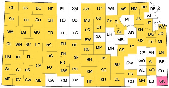
Cherokee County occupies an area of 587 square miles (1,520 km2) in the southeast corner of Kansas. The county is bounded on the east and south by the Missouri and Oklahoma State lines, respectively, on the west by Labette County, and on the north by Crawford County. The location of the county is shown on the cover.
Cherokee County occupies parts of two physiographic provinces defined by Fenneman (1949). Most of the county is in the Osage Plains section of the Central Lowland province, which comprises the typical rolling prairie of eastern Kansas. Large parts of the county that are underlain by easily erodable shale appear to be nearly flat.
The area generally east of the Spring River is in the Springfield Plateau section of the Ozark Plateaus province and is typical of the hilly timbered land in the Missouri Ozarks. Local relief between hilltops and stream valleys is as much as 200 feet (61 m) in this area.
The county is drained by the Neosho and Spring Rivers and their tributaries. Principal tributaries of the Neosho River in Cherokee County are Lightning, Cherry, and Fly Creeks. Principal tributaries of the Spring River are Cow, Shawnee, Shoal, and Brush Creeks.
Rocks exposed at the land surface in Cherokee County are mostly limestone and shale of Mississippian and Pennsylvanian age, and silt, clay, sand, and gravel of Quaternary age. The areal distribution of the rocks is shown on plate 1. The consolidated rocks dip westerly or northwesterly at about 20 feet per mile (4 m/km), and progressively older rocks, therefore, are exposed from west to east. The rocks contain mineral resources of coal, lead and zinc, fireclay, and rock suitable for construction purposes that have contributed greatly to the economy of Cherokee County and vicinity. Unconsolidated deposits of silt, clay, sand, and gravel of Quaternary age fill stream valleys incised into the older rocks. A generalized columnar section of the geologic units is given in table 1. The classification and nomenclature of rock units used in this report are those of the Kansas Geological Survey and differ somewhat from those used by the U.S. Geological Survey.
Table 1--Generalized columnar section of the surficial rocks in Cherokee County, southeastern Kansas.
| System | Series | Stage | Geologic unit |
Average thickness (feet) |
Description |
|---|---|---|---|---|---|
| Quaternary | Pleistocene | Recent and Wisconsinan | Alluvium | 30 | Silt, and silty sand, gray to grayish-brown, limonite stained in part; contains some sand and medium to coarse gravel at base. |
| ? | |||||
| Wisconsinan and Illinoisan (?) | Terrace deposits | 25 | |||
| Pennsylvanian | Middle Pennsylvanian | Desmoinesian | Fort Scott Limestone | 20 | Limestone, light-gray to brownish-gray, and black to light-gray shale |
| Cabaniss Formation | 225 | Shale, light- to dark-gray; contains siltstone, limestone, sandstone, and coal. Commercially most important coal beds in Kansas occur in this formation. | |||
| Krebs Formation | 225 | Shale, light- to dark-gray, and fine- to medium-grained sandstone; contains coal, underclay, siltstone, and some limestone locally. | |||
| Mississippian | Upper Mississippian | Chesteran | Undifferentiated rocks of Chesteran age | 120 | Limestone, shaly, and calcareous shale; contains some oolitic limestone and sandy shale. |
| Meramecian | Warsaw Limestone | 120 | Limestone, crinoidal; contains much gray chert. Base marked by glauconite-rich layer known locally as the "J-bed". Contains deposits of lead and zinc of commercial value. | ||
| Lower Mississippian | Osagian | Keokuk Limestone | 130 | Limestone, medium to coarsely crystalline, bluish-gray, and gray chert; contains oolitic limestone near top. Cherty parts weather to characteristic reddish-brown color. Contains deposits of lead and zinc of commercial value. | |
| Fern Glen Limestone | 170 | Limestone. Reeds Spring Limestone Member (upper unit) is cherty, finely crystalline, bluish- gray. Contains deposits of lead and zinc of commercial value. St. Joe Limestone Member (lower unit) is crinoidal, dolomitic in part, green. |
The oldest rocks exposed at the land surface in Cherokee County are of Mississippian age; they consist primarily of limestone and chert and are not differentiated on the geologic map (pl. 1).
In Kansas, the Fern Glen Limestone of Osagian age consists of two members, the St. Joe Limestone Member (lower unit) and the Reeds Spring Limestone Member (upper unit). Only the Reeds Spring crops out in Cherokee County.
The Reeds Spring Limestone Member is about 150 feet (46 m) thick in Cherokee County and consists mainly of alternating bands of bluish-gray finely crystalline limestone and chert. The chert is abundant. The upper part of the Reeds Spring, about 45 feet (14 m) thick, has been called the Grand Falls Chert. Although the Grand Falls Chert is not recognized formally in Kansas, owing to its limited outcrop area, it is considered to be a separate formation in Missouri (Howe, 1961). The chert in the unit is gray to brown. Near the outcrop it breaks into distinctive sharp fragments and is known locally as "butcher-knife chert." The deposits of lead and zinc that have been mined throughout the Tri-State District (Missouri-Kansas-Oklahoma) occur primarily in the Grand Falls Chert and in the overlying rocks of Mississippian age. Some lead and zinc also have been produced in the Tri-State District from rocks of Desmoinesian age (McKnight and Fischer, 1970).
The Keokuk Limestone of Osagian age is believed to rest disconformably on the Reeds Spring Limestone Member of the Fern Glen Limestone (Lee, 1940, p. 58; Howe, 1961, p. 64). The Keokuk, which is about 130 feet (40 m) thick, is characteristically a bluish-gray, medium- to coarse-crystalline limestone that contains abundant gray chert, both nodular and layered. The limestone weathers to light gray and the chert weathers to a characteristic reddish brown. Large quantities of porous opaque white chert known as cotton rock are a distinctive feature of the Keokuk and are particularly common in the lower part of the formation.
Another distinctive feature of the Keokuk is an oolitic limestone unit known informally (in Kansas) as the Short Creek Oolite. This unit, which is 5 to 10 feet (1.5 to 3 m) thick, occurs about 14 feet (4 m) below the top of the Keokuk and is used widely as a marker bed.
The Warsaw Limestone (Meramecian Stage) is the uppermost formation of Mississippian age in most of Cherokee County. The Warsaw is about 120 feet (37 m) thick; it rests unconformably on the Keokuk and the contact is marked by a glauconite-rich zone known locally as the "J bed". The Warsaw contains abundant chert, is crinoidal, and, unless the Short Creek Oolite of the Keokuk Limestone or "J bed" is located, is difficult to distinguish from the Keokuk. The highest hills and ridges in the vicinity of Galena are capped by Warsaw Limestone, but outcrops generally are covered by residual chert. The formation is exposed in several sinkholes and cave-ins in eastern Cherokee County.
Smith and Siebenthal (1907) mapped several isolated patches of shaly limestone, calcareous shale, sandy shale, and sandstone in the vicinity of Galena that are of Chesteran age. These rocks are thought to be erosional remnants preserved in sinkholes and solution depressions that had developed on the surface of the Warsaw Limestone. Exposures of the Chesteran rocks are difficult to find in Cherokee County at present (1973) because much of the outcrop area has been covered by tailings from lead and zinc mines.
Most of Cherokee County is underlain by shale and sandstone of Desmoinesian age that compose the Cherokee Group. These rocks contain commercially important deposits of coal. The Fort Scott Limestone, which is the basal formation of the Marmaton Group (Desmoinesian), is the uppermost unit of Pennsylvanian age in Cherokee County.
A detailed description of the Krebs and Cabaniss Formations, which compose the Cherokee Group, is given by Howe (1956). In this report, therefore, only a summary description of the rocks is given and the formations are arbitrarily subdivided according to units that are mapable in Cherokee County. Table 2, from Zeller (1968), shows a columnar section of the rocks that compose the Cherokee Group.
Table 2--Columnar section of the Cherokee Group in Kansas (from Zeller, 1968).
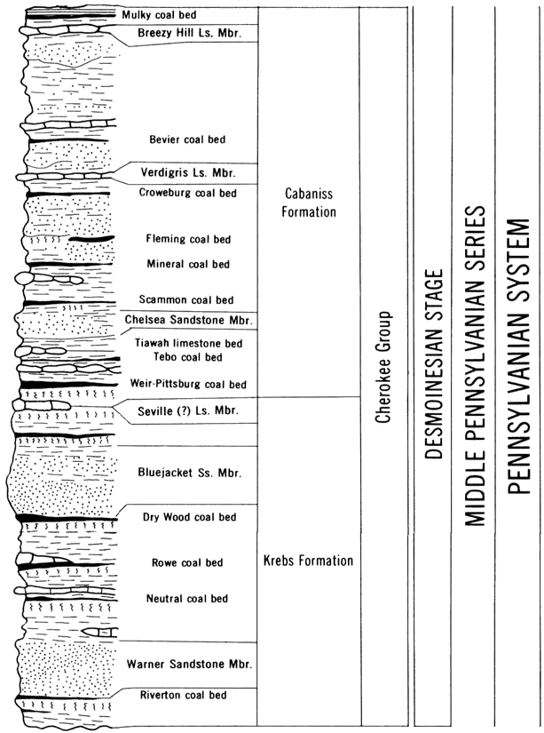
The Krebs Formation (pl. 1) is about 225 feet (69 m) thick in Cherokee County. The formation is subdivided into five units in this report.
The lowermost rock unit, below the Warner Sandstone Member, consists of shale, underclay, and coal. This unit is 10 to 20 feet (3 to 6 m) thick in the eastern part of Cherokee County and thickens to as much as 50 feet (15 m) in the western part. The basal shale is dark gray to black and weathers to a distinctive metallic bluish gray. The shale is almost fissile and generally contains marcasite and pyrite; it is overlain by a light- to medium-gray underclay. The top of the unit consists of a persistent bed of coal about 1 foot (0.3 m) thick that is known as the Riverton coal bed.
The Warner Sandstone Member of the Krebs Formation directly overlies the Riverton coal bed in most of Cherokee County. Locally, however, a thin dark-gray shale occurs between the coal and the sandstone. Average thickness of the Warner is 15 feet (5 m), although it is as much as 30 feet (9 m) thick in places. The Warner consists of (1) a lower cross-bedded fine- to medium-grained angular to subrounded sandstone, (2) a micaceous siltstone and sandy shale, and (3) an upper massive fine-grained sandstone. The lower sandstone is the unit most commonly exposed, and is the basis of many descriptions of the Warner Formation. The Warner is light gray on fresh surfaces, but, because it contains ferruginous cement, it weathers to dark reddish brown. Soils developed on the Warner generally are the same reddish brown color.
The interval between the Warner Sandstone Member and the Bluejacket Sandstone Member of the Krebs Formation is about 100 feet (30 m) thick; it consists mostly of dark-gray to black shale. The upper part, about 30 feet (9 m) thick, of the interval contains three beds of coal, underclay, and some impure silty limestone. The coals, in ascending order, are the Neutral, Rowe, and Dry Wood, which are about 0.5 foot (0.2 m), 1.5 feet (0.5 m), and 1.0 foot (0.3 m) thick, respectively. Both the Rowe and Dry Wood coal beds have been mined in Cherokee County.
The Bluejacket Sandstone Member of the Krebs Formation is the most prominent rock unit in Cherokee County. The sandstone supports a prominent cuesta and caps several outliers and buttes in the southern part of the county where it averages 40 feet (12 m) in thickness. North of Columbus, the unit thins abruptly to about 10 feet (3 m) and outcrops become much less prominent. As indicated on the geologic map, the base of the unit is not exposed everywhere in the county.
The Bluejacket is composed mainly of fine- to medium-grained sandstone that contains some very fine sand and silt. Parts of the unit exhibit horizontal bedding whereas other parts, particularly where the unit is thick, are cross bedded. The sandstone is tan to brown; it generally is well-cemented with ferruginous material and weathers to a distinctive reddish brown. Soils developed on the sandstone are similar in color, which aids identification of the unit in areas where it is not prominently exposed.
The interval between the top of the Bluejacket Sandstone Member and the top of the Weir-Pittsburg coal bed includes the contact between the Krebs and Cabaniss Formations. This interval, which is about 60 feet (18 m) thick, is completely covered in Cherokee County. The Bluejacket is overlain by about 50 feet (15 m) of light- to medium-gray shale, about 6 feet (2 m) of light-gray silty underclay, and about 3 feet (1 m) of coal known as the Weir-Pittsburg coal bed. In the SW sec. 28, T. 30 S., R. 25 E., which is about 3 miles (5 km) north of the Cherokee County line, Howe (1956, p. 44) identifies a "thin smut" of coal above the sandstone as the Bluejacket coal, and an impure argillaceous limestone about 0.5 foot (0.2 m) thick overlying the coal as the Seville Formation (Seville Limestone Member of the Krebs Formation in current nomenclature of the Kansas Geological Survey). This limestone is the uppermost unit of the Krebs Formation. Neither the Bluejacket coal nor the Seville has been identified in Cherokee County. If present, the Seville would separate the gray shale from the underclay of the Weir-Pittsburg coal bed.
Because the entire interval between the top of the Bluejacket Sandstone Member and the top of the Weir-Pittsburg coal bed is covered and the Seville Limestone Member is not everywhere present, the approximate contact between the Krebs and Cabaniss Formations is shown on the geologic map (pl. 1). The contact shown (top of Weir-Pittsburg coal bed) is about 9 feet (3 m) above the actual Krebs-Cabaniss contact.
The Cabaniss Formation, which comprises the upper part of the Cherokee Group, is about 225 feet (69 m) thick and contains less clastic material and more limestone than the underlying Krebs Formation. Much coal has been mined from the Cabaniss, as indicated by the strip-mined areas shown on the geologic map (pl. 1). The base of the Cabaniss Formation in Cherokee County is placed at the base of the Weir-Pittsburg coal bed (see previous discussion of Krebs Formation).
The interval between the top of the Weir-Pittsburg coal bed and the Mineral coal bed is about 90 feet (27 m) thick; it contains the Tebo coal bed, the Tiawah limestone bed, the locally prominent Chelsea Sandstone Member of the Cabaniss Formation, and the Scammon coal bed. Most of the interval is shale, as both the coals and the limestone are each about 0.5 foot (0.2 m) thick and the sandstone is about 10 feet (3 m) thick. Not all the units are present everywhere, which makes the stratigraphy of the interval highly variable from place to place.
The interval between the base of the Mineral coal bed and the top of the Verdigris Limestone Member of the Cabaniss Formation is about 35 feet (11 m) thick. In addition to the Mineral coal, two other coal beds in the interval, the Fleming and Croweburg, also have been mined in Cherokee County. Most of the interval is gray to dark-gray shale. The Mineral coal bed ranges in thickness from about 1.5 to 2 feet (0.5 to 0.6 m); the Fleming and Croweburg coals each are about 1 foot (0.3 m) thick. The Verdigris Limestone Member is the most persistent limestone in the Cabaniss Formation; it generally is considered to be a reliable marker bed. As described by Howe (1956, p. 74-77), the Verdigris overlies a black fissile shale and consists of three limestones separated by shale. The two lower limestones are each about 1 foot (0.3 m) thick, are dark gray to black, and are separated by 1.5 to 5 feet (0.5 to 2 m) of black fissile shale. The upper limestone is about 2 feet (0.6 m) thick, massive, and light to dark gray. This upper limestone commonly forms prominent ledges where the Verdigris is exposed in the northwestern part of Cherokee County.
The interval between the top of the Verdigris Limestone Member and the top of the Cabaniss Formation is about 90 feet (27 m) thick and consists mostly of light-gray shale and siltstone. The Bevier coal bed, which occurs near the bottom of the interval, ranges in thickness from 1.5 to 2 feet (0.5 to 0.6 m) in Cherokee County. Large amounts of coal have been strip mined from the Bevier. A light-gray shale about 30 feet (9 m) thick that occurs above the Bevier coal bed has been mined for the manufacture of brick and tile.
The Breezy Hill Limestone Member, which occurs near the top of the Cabaniss Formation, consists of two distinct types of limestone according to Howe (1956, p. 85). Near the Oklahoma border, the unit is as much as 16 feet (5 m) thick and consists of thin-bedded to massive, dense to medium-grained, brown to gray limestone that weathers buff to brown. In most of southeastern Kansas and in western Missouri, the Breezy Hill consists of nodular irregularly bedded sandy to conglomeratic limestone that is about 3 feet (1 m) thick. The Breezy Hill generally is overlain by 2 to 4 feet (0.6 to 1 m) of underclay and by the Mulky coal bed, which has been mined locally in Cherokee County. The underclay is as much as 11 feet (3 m) thick in the county according to Howe (1956, p. 87); the coal generally is about 1 foot (0-3 m) thick.
The uppermost rock unit in the Cabaniss Formation is a black fissile shale that overlies the Mulky coal bed. The shale is persistent and commonly is about 5 feet (2 m) thick.
The Marmaton Group of Desmoinesian age comprises an alternating series of limestone and shale formations that contain some sandstone and coal. Only the basal formation of the group, the Fort Scott Limestone, is present in Cherokee County.
The uppermost rock unit of Pennsylvanian age in Cherokee County is the Fort Scott Limestone (pl. 1). The formation is about 20 feet (6 m) thick in the county and contains three members, the Blackjack Creek Limestone Member (lower), the Little Osage Shale Member (middle), and the Higginsville Limestone Member (upper). These rocks support a prominent ridge and form an escarpment in the northwest part of the county.
The Blackjack Creek Limestone Member is about 10 feet (3 m) thick in Cherokee County and consists of a light-gray fine-grained limestone that weathers to a buff color. Above the limestone is the Little Osage Shale Member, which is about 5 feet (2 m) thick and characteristically is dark-gray to black shale. The member contains phosphatic nodules and some gray silty shale. The Higginsville Limestone Member is not well exposed in Cherokee County, but, where seen, it is a medium- crystalline light-gray fossiliferous limestone that weathers to light yellow. Bedding in the member ranges from thick to medium; locally it is wavy or undulating.
Unconsolidated deposits of silt, sand, clay, and gravel underlie flood plains and terraces of the major streams in Cherokee County. The deposits range in age from Illinoisan (?) to Recent.
An extensive terrace that is 2 to 4 miles (3 to 6 km) wide borders the eastern side of the Neosho River valley in Cherokee County (pl. 1). The terrace is underlain chiefly by light-gray limonite-stained silty clay that contains medium to coarse chert gravel at the base. These terrace deposits are about 25 feet (8 m) thick. The lithology and thickness of the deposits is uniform, as is the position of the terrace, which ranges from 25 feet (8 m) above the flood plain near the stream to 50 feet (15 m) above the flood plain near the edge of the valley. Because of the consistent lithology, thickness, and position, these terrace deposits are considered to be Illinoisan in age.
Terraces only a few feet above the flood plains of the major streams in Cherokee County are underlain by deposits that are considered to be Wisconsinan in age. These low terrace deposits are more limited in areal extent, more heterogeneous in composition, and darker in color than terrace deposits along the east side of the Neosho River valley. The two terraces are not differentiated on the geologic map.
Alluvium of Wisconsinan and Recent age underlies the flood plains of the major streams in Cherokee County (pl. 1). The alluvium consists primarily of dark-gray and grayish-brown silt, sandy silt, and fine sand with medium to coarse, angular to subrounded gravel at the base. Thickness of the alluvium is as much as 30 feet (9 m). The basal gravel generally is about 2 feet (0.6 m) thick, but locally it may be as much as 10 feet (3 m) thick.
Camin, K. Q., and Hardy, R. G., 1972, Mined-land redevelopment: southeast Kansas portion of the Ozarks Region: Mineral Resources Task Group final report to the Ozarks Regional Commission, 1971-72, 173 p.
Fenneman, N. M., 1949, Physical divisions of the United States: U.S. Geol. Survey map.
Howe, W. B., 1956, Stratigraphy of pre-Marmaton Desmoinesian (Cherokee) rocks in southeastern Kansas: Kansas Geol. Survey, Bull. 123, 132 p. [available online]
Howe, W. B., 1961, The stratigraphic succession in Missouri: Missouri Geol. Survey and Water Resources, v. XL, second series, 185 p.
Lee, Wallace, 1940, Subsurface Mississippian rocks of Kansas: Kansas Geol. Survey, Bull. 33, 114 p. [available online]
McKnight, E. T., and Fischer, R. P., 1970, Geology and ore deposits of the Picher field, Oklahoma and Kansas: U.S. Geol. Survey, Prof. Paper 588, 165
Pierce, W. G., and Courtier, W. H., 1937, Geology and coal resources of the southeastern Kansas coal field in Crawford, Cherokee, and Labette Counties: Kansas Geol. Survey, Bull. 24, 122 p.
Smith, W. S. T., and Siebenthal, C. E., 1907, Description of the Joplin District, Missouri-Kansas: U.S. Geol. Survey, Geol. Atlas, Folio 148.
Zeller, D. E., 1968, The stratigraphic succession in Kansas: Kansas Geol. Survey, Bull. 189, 81 p. [available online]
Kansas Geological Survey
Comments to webadmin@kgs.ku.edu
Web version placed online Oct 27, 2010. Original publication date March 1975.
URL=http://www.kgs.ku.edu/Publications/Bulletins/GS1/index.html