Kansas Geological Survey, Guidebook 3, originally published in 1978
Prev Page--Start of Report
Figure 12--Map showing route of first day of field trip (April 13, 1978). Geology modified from Geologic Map of Kansas (1964).
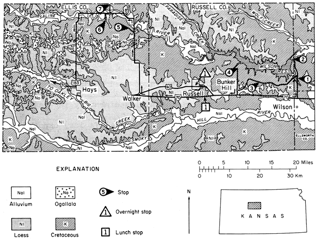
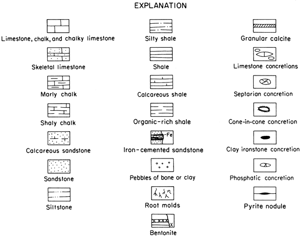
Figure 13--Explanation of symbols used in graphic sections.
0.0 miles Intersection of I-70 and K-32.
Proceed north on K-232.
0.5 miles Low escarpment (left) capped by Greenhorn Limestone.
0.8 miles Ascending Greenhorn escarpment.
1.3 miles Poor exposures of Greenhorn Limestone, both sides of highway.
1.5 miles Entering Lincoln County. Valleys on both sides of highway dissect Greenhorn escarpment; escarpment well developed on left (9:00-11:00). Approximate position of Graneros-Greenhorn contact at first break in slope below top of escarpment. Dakota Formation present in valley floors.
2.2 miles Descending Greenhorn escarpment. Low exposures of Greenhorn Limestone on both sides of highway.
2.5 miles Base of Greenhorn Limestone; Graneros shale poorly exposed below Greenhorn.
2.9 miles Low mound on right (3:00) capped by sandstone in Dakota Formation; at 2:00 in near distance flat-bedded sandstone overlies variegated mudstone in Dakota (continental sedimentary facies).
3.2-3.5 miles Dakota Formation (fluvial continental facies) exposed in low cuts on both sides of highway. Trough crossbedded channel sandstone and variegated floodplain mudstone complexly interrelated here.
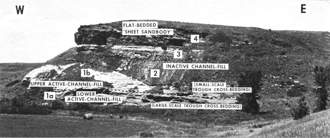
4.1 miles STOP 1. Dakota Formation--fluvial facies. See graphic section (figure 14) and photographs (figures 14, 15).
Figure 14--Photograph and lithologic sketch of Dakota strata exposed at STOP 1. This exposure illustrates complex relationships of lithologic units in nonmarine fluvial channel and floodplain facies and marginal-marine deltaic facies in upper part of Dakota Formation. In general, unit 1 represent active-channel; units 2-6 represent complex floodplain and partly abandoned channel-fill processes; units 7-12 probably represent complex mixed fluvial to marginal-marine deposition in deltaic environment; and units 13-15 may represent marginal-marine sand deposition across a deltaic surface during initial phase of Graneros transgression. Elsewhere Graneros Shale commonly overlies units such as 14 and 15, but has been stripped off here. Discordant surface labeled 4 is a spectacular feature of this exposure and may represent faulting of unit 5 against units 1 and 2 prior to deposition of unit 6. This surface may, however, be an erosional scarp of some sort, as indicated by numerous large exotic siltstone blocks in close proximity to discordant surface in shale of unit 5.
Main features of the lithologic units delineated are:
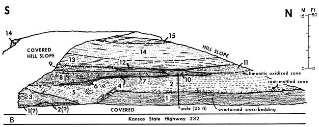
Figure 15--Spectacular 100-foot (30-m) thick section of upper part of Dakota Formation exposed at STOP 1. Units 1a and 1b represent active channel fill of Rocktown channel sandstone body; unit 1a is characterized by large (1 to 3 feet (0.3 to 0.9 m) high and 5 to 15 feet (1.5 to 4.6 m) across) trough features and medium- to fine-grained sand with mudstone clasts and limonitized wood and plant debris; unit 1b is characterized by relatively small-scale (0.5 to 1.5 foot (0.15 to 0.46 m) thick) trough crossbed sets and fine- to very fine-grained sand. About 15 feet (4.6 m) of unit 1a is exposed; unit 1b is as much as 25 feet (7.6 m) thick. Sandstone body of unit 1 is truncated by carbonaceous silty claystone and shale (interlaminated with siltstone and clayey sandstone) of unit 2, which represents inactive fill of an abandoned channel; plant debris and root mottling is common. Unit 2 is as much as 25 feet (7.6 m) thick. Unit 3 is a root-mottled, carbonaceous sandy siltstone (as much as 16 feet (4.9 m) thick) of somewhat indeterminate origin but possibly related to units 8-12 (figure 14) exposed in nearby cut. Unit 4 is same as unit 14 in nearby cut (figure 14); as much as 31 feet (9.5 m) of flat-bedded sandstone is exposed here. The very fine grained sandstone contains abundant iron-stained plant debris, sparse burrows, and Teredolithus borings in wood; ripple-bedding and small-scale trough cross-bed sets are abundant, especially in upper part of exposure.
4.5 miles Dakota Formation (fluvial facies) exposed on both sides of highway. Variegated mudstone with thin lenticular sandstone beds is overlain by flat-bedded sandstone which caps crossbedded channel facies and extends laterally so as to also overlie floodplain facies.
4.9 miles Dakota (fluvial facies) exposed on right.
5.3 miles Greenhorn Limestone exposed poorly on left.
5.4 miles Intersection with Farm Access Road 918 (FAS 918), to Hell Creek Bridge, on left; continue straight ahead. Greenhorn Limestone on left, just beyond intersection.
6.0 miles Top of Greenhorn escarpment. Corral of left; view of Wilson Reservoir on left.
6.7 miles Entering Russell County; begin descent of Greenhorn escarpment. Greenhorn Limestone well exposed in cuts on both sides of highway to mileage 7.3.
7.3 miles Graneros Shale exposed poorly in gully on right.
7.4 miles Dakota Formation exposed in gully on right. Variegated mudstone and lenticular sandstone bodies.
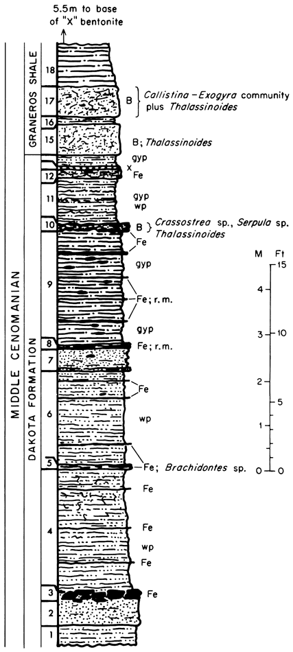
8.1 miles STOP 2. Dakota Formation--clay-ironstone facies. See graphic section (figure 16).
Figure 16--Graphic column of upper Dakota and lower Graneros strata exposed at spillway of Lake Wilson (STOP 2). At this locality sideritic clay-ironstone bearing sandy shales and ferruginous sandstones in upper part of Dakota Formation represent marginal-marine brackish lagoon or interdistributary bay deposition. Fine-grained wood and plant debris (labeled wp on column) and root molds (r.m.) are common. one specimen of Brachidontes sp. and several specimens of Crassostrea sp. and Serpula sp. were collected from beds indicated. Burrow mottling (B) and distinct Thalassinoides burrows occur in uppermost part of Dakota (bed 10) and lower yellowish sandstone beds of Graneros Shale (beds 15-17). Gypsum (gyp) is abundant on outcrop as weathering product.
8.3 miles Wilson Dam. Turn around at roadside park and retrace route to FAS 918.
11.3 miles Intersection with road leading to Hell Creek Bridge (FAS 918). Turn right and proceed westward towards bridge. Greenhorn Limestone exposed in cuts on both sides of road at intersection. Road descends section from Greenhorn Limestone through Graneros Shale, into Dakota Formation.
11.5 miles Dakota sandstone poorly exposed in valley on right.
11.55 miles Dakota exposed in roadcuts on both sides of road. Clay-ironstone facies with thin lenticular sandstone beds.
11.65 miles Dakota exposed in roadcut on right Variegated and carbonaceous mudstone and thin lenticular sandstone-fluvial facies.
11.9-12.2 miles Hell Canyon Bridge. Rocktown channel sandstone (informal member) of Dakota well exposed along west side of reservoir at west end of bridge.
12.2 miles Variegated floodplain mudstone of Dakota exposed along both sides of road.
12.5 miles Exposure on left displays carbonaceous shaly mudstone with steeply (20-25°) inclined bedding (upper-channel fill?) overlain by flat- bedded sandstone cap, which is in turn overlain by ferruginous sandstone of the Dakota.
12.6 miles Flat-bedded fluvial sandstone of Dakota exposed on left.
12.7 miles Dakota (fluvial facies) exposed along both sides of road.
12.8 miles Crossbedded fluvial sandstone of Dakota overlain by rubbly ferruginous sandstone.
12.9 miles Intersection of FAS 918 and Wilson State Park road (right). Continue west on FAS 918.
13.3 miles Dakota (fluvial facies) exposed poorly on both sides of road.
13.6-13.7 miles Cuts on both sides of road expose crossbedded fluvial sandstone of Dakota.
14.0 miles Crossbedded channel sandstone of Dakota in small cuts on both sides of road.
14.3 miles Farmhouses on left constructed of stone from Fencepost limestone bed of Greenhorn Limestone.
14.5 miles Intersection with country road. Continue west on paved road.
14.6 miles Corral on right. Dakota sandstone (fluvial facies) exposed in low cuts on both sides of road.
15.1 miles Begin ascent of Greenhorn escarpment. Dakota floodplain mudstone poorly exposed on left.
15.2-15.4 miles Deep roadcut on left. Upper part of Graneros (with X-bentonite marker bed) at base of exposure. Lincoln, Hartland, and lower part of Jetmore members of Greenhorn Limestone well exposed.
15.45 miles Cuts on both sides of road expose Lincoln Member of Greenhorn. Lowermost part of Hartland Member exposed at top of cut on left.
15.7 miles Dakota exposed in roadcut on left. Rubbly, fossiliferous, ferruginous sandstone and silty shale (shallow marine facies) of upper Dakota overlain by lowermost part of Graneros Shale.
16.0 miles Low roadcuts in Dakota (fluvial facies).
16.1 miles Roadcuts in fluvial facies of Dakota.
16.2 miles Ferruginous, crossbedded fluvial sandstone of Dakota exposed in valleys on both sides of road.
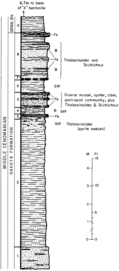
16.5-16.6 miles STOP 3. Shallow marine facies of Dakota Formation, overlain by complete section of Graneros Shale and lower beds of Lincoln Member, Greenhorn Limestone. See graphic section (figure 17).
Figure 17--Graphic column of upper Dakota and lower Graneros strata exposed at STOP 3. Sideritic clay-ironstone cemented sandstone units in uppermost part of Dakota here contain abundant macroinvertebrate body fossils and the trace fossils Thalassinoides and Teichichnus. Diverse macroinvertebrate assemblage listed below was collected from bed 5 and is indicative of nearshore marine setting. Identified taxa include:
Thalassinoides burrows are preserved as pyrite nodules in shale of upper part of unit 2 and as ferruginous burrows in sandstone units 5 and 8, which are intensely burrow mottled (B). Well-developed Teichichnus burrows also are common in units 5 and 8; many specimens grade into Thalassinoides structures, illustrating variability of such form ichnogenera.
17.1-17.4 miles Long roadcuts in carbonate section expose most of Lincoln Member of Greenhorn Limestone through lower part of Fairport Member of Carlile Shale.
17.5 miles Cuts, both sides of road, expose lower part of Fairport Member, Carlile Shale.
17.6-17.8 miles Roadcuts expose carbonate section extending from lower part of Fairport Member, Carlile Shale, downward to upper part of Lincoln Member, Greenhorn Limestone.
18.1 miles Cuts on both sides of road expose upper part of Graneros Shale and most of Lincoln Member of Greenhorn.
18.3 miles Roadcut on right exposes most of Lincoln Member and lower part of Hartland Member, Greenhorn Limestone.
18.4 miles Roadcut on right exposes Hartland Member and most of Jetmore Member, Greenhorn Limestone.
18.5 miles Roadcut on right exposes upper part of Hartland Member and lower part of Jetmore Member, Greenhorn Limestone.
18.6 miles Cuts on both sides of road expose upper part of Jetmore Member and Pfeifer Member of Greenhorn and basal part of Fairport Member, Carlile Shale.
18.7 miles Cross road. Road on right leads to Minooka Park. Proceed straight ahead.
18.8 miles Low cuts on both sides of road expose uppermost Pfeifer Member of Greenhorn and lowermost Fairport Member of Carlile.
18.9 miles Low roadcut on right exposes uppermost part of Pfeifer Member, Greenhorn Limestone, lowermost part of Fairport Member, Carlile Shale.
19.1 miles Low cuts on both sides of road expose small portion of lower Fairport Member, Carlile Shale.
19.2 miles Weathered exposure, part of lower Fairport Member, Carlile Shale.
19.4-19.5 miles Long, deep roadcut exposes lower 15 to 20 feet of Fairport Member of Carlile, and Pfeifer Member, Jetmore Member, and uppermost part of Hartland Member of Greenhorn.
19.6 miles Fluvial channel sandstone facies of Dakota Formation well exposed at bottom of draw on right.
19.7-19.8 miles Deep cuts on both sides of road expose upper half of Hartland Member and Jetmore and Pfeifer Members of Greenhorn.
19.9 miles Cuts on both sides of road expose upper part of Jetmore Member and lower part of Pfeifer Member, Greenhorn Limestone.
20.0 miles Cuts on both sides of road expose Pfeifer Member of Greenhorn and lower part of Fairport Member, Carlile Shale.
20.1 miles For next 1.4 miles road crosses upland surface underlain by Fairport Member of Carlile.
21.1 miles Cuts on both sides of road expose uppermost part of Pfeifer Member of Greenhorn and lowermost part of Fairport Member of Carlile.
21.2 miles View right toward upper reaches of Wilson Reservoir.
21.3 miles Cuts on both sides of road expose Pfeifer, Jetmore, and Hartland members of Greenhorn.
21.5-21.6 miles Cut on right side of road exposes Lincoln Member of Greenhorn, Graneros Shale, and uppermost part of Dakota Formation.
21.8 Small excavation at right exposes floodplain mudstone facies of Dakota.
21.9 miles In next 0.2 mi. several low roadcuts expose Pleistocene slope deposits.
22.2 miles View right (1:30) of channel sandstone facies of Dakota on hill slope.
22.3 miles Old excavations on left expose mudstone facies of Dakota.
22.4-22.7 miles Cuts on both sides of road expose Dakota (floodplain facies with crossbedded channel sandstone, overlain by shallow marine facies), entire Graneros Shale interval, and Lincoln, Hartland, Jetmore, and Pfeifer (lower part) members of Greenhorn.
22.8-23.1 miles Cuts along both sides of road expose lower part of Fairport Member of Carlile Shale, Greenhorn Limestone, and upper part of Graneros Shale.
23.2 miles Channel sandstone facies of Dakota exposed on hill slope on right.
23.4 miles Roads converge at end of pavement. Proceed straight ahead on gravel road.
23.5 miles Cut on left exposes floodplain facies of Dakota overlain by flat-bedded fluvial sandstone facies of Dakota.
24.1 miles Low roadbank on right exposes Quaternary terrace deposits.
24.4 miles Cut bank on intermittent stream at left (3:00) exposes flat-bedded fluvial sandstone facies of Dakota.
24.8 miles Low roadcut on right exposes Quaternary terrace deposits.
24.9-25.0 miles Low roadcut on right with poor exposures of Graneros Shale.
25.2-25.4 miles Long deep roadcut on right exposes Lincoln (upper part), Hartland, Jetmore, and Pfeifer members of Greenhorn Limestone and basal part of Fairport Member, Carlile Shale.
25.5 miles For next several miles road crosses upland surface underlain by lower part of Carlile Shale.
25.6 miles Low roadcuts expose a highly weathered portion of the Fairport Member, Carlile Shale.
26.0 miles Low cuts on both sides of road expose part of lower portion of Fairport Member, Carlile Shale.
26.2 miles Low roadbank on left exposes part of lower portion of Fairport Member.
26.6 miles Converging roads, with cemetery at left. Proceed straight ahead.
26.9 miles Low banks on both sides of road expose part of lower portion of Fairport Member, with many oysters.
27.0 miles Side road left. Proceed straight ahead.
27.5 miles Intersection of gravel road and Bunker Hill-Luray road. Turn right (north) on paved road.
28.2 miles Lower part of Fairport exposed in roadside ditch on right. (Inoceramus cuvieri, C. woollgari, burrows, Pseudoperna, "pink lime" exposed here).
28.8-28.9 miles Upper part of Pfeifer Member and lower part of Fairport Member exposed in long roadcut. Fencepost limestone bed conspicuous in middle part of section.
29.0 miles Upper two-thirds of Hartland Member and lower part of Pfeifer Member exposed on right in cut bank of intermittent stream. Roadcut ahead is in upper part of Pfeifer and lower part of Fairport.
29.1 miles Upper part of Pfeifer Member, Greenhorn Limestone, in low cuts on both sides of road.
29.4 miles Note use of stone posts in fences on both sides of road.
29.7 miles Side road on right marks top of Bunker Hill section. Re-board bus here after STOP 4.
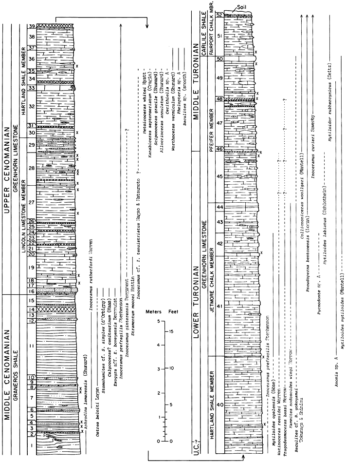
30.2 miles STOP 4. Base of Bunker Hill section (Graneros Shale). On foot ascend hill through entire thickness of Greenhorn Limestone. See graphic section (figure 18).
Figure 18--Graphic column of upper Graneros, Greenhorn, and lower Fairport strata exposed north of Bunker Hill (STOP 4), near center of west line sec. 18, T. 13 S., R. 12 W., Russell County, Kansas. Section measured by Donald E. Hattin, 1962, 1964.
30.7 miles Re-board bus at top of hill. Proceed south on Bunker Hill-Luray road.
32.9 miles Junction with road (left) to Minooka Park. Proceed straight ahead.
33.6 miles Grade crossing at Union Pacific R.R. at north edge of Bunker Hill, Kansas.
34.8 miles Junction of Bunker Hill-Luray road with I-70. Turn right (west) onto I-70.
35.8 miles Upper part of Jetmore in low roadcut.
38.6 miles Russell exit at US-40. Proceed on I-70.
40.5 miles Roadside rest area. Lunch stop. For next several miles highway crosses upland surface underlain by upper part of Greenhorn Limestone and lower part of Fairport Member, Carlile Shale. After lunch proceed west on I-70.
42.8 miles US-281 interchange on I-70. Proceed west on I-70. Oil wells are in northern edge of Hall-Gurney field. This field, discovered in 1931, has produced nearly 130 million bbls from the Cambrian-Ordovician, Upper Pennsylvanian, and Lower Permian.
43.8 miles Oil field on both sides of highway is part of Russell oil field, producing from rocks of the Arbuckle Group (Cambrian-Ordovician) and the Kansas City and Lansing groups (Pennsylvanian) on the Central Kansas Uplift. For next several miles route crosses loess-veneered Cretaceous rocks.
46.9 miles Russell (Balta Rd.) exit. Proceed west on I-70. From here to next exit road passes through the Gorham oil field. This field, discovered in 1926, has produced approximately 87 million bbls from the Arbuckle, Upper Pennsylvanian, and Lower Permian.
52.0 miles Gorham interchange. Proceed west on I-70.
53.0 miles Entering Ellis County.
54.7 miles Walker interchange. Leave I-70.
54.8 miles Junction of exit ramp and county road. Turn right (north) towards Walker, Kansas.
55.5 miles Intersection of county road and US-40 in Walker. Proceed straight (north) on county road. (If roads are wet, alternate route will be followed west to Victoria, thence north to Saline River valley, thence southeast to STOP 5 via Saline Valley Road). For next several miles route crosses loess-covered Carlile Shale.
57.8 miles Crossroad. Hills on horizon to north are capped by Fort Hays Limestone Member of Niobrara Chalk.
61.8 miles "T" intersection. Turn left (west).
62.8 miles Crossroad. Turn right (north). The numerous small oil fields between Walker and STOP 5 were discovered after World War II. Production is largely from the Arbuckle and/or Upper Pennsylvanian.
63.4-63.6 miles Ascending Fort Hays escarpment. Codell Sandstone Member of Carlile Shale, exposed in ditches at 63.5, consists of soft argillaceous siltstone. Extensively burrowed chalky limestone in ditch on left at 63.6 is basal part of Fort Hays Limestone Member, Niobrara Chalk.
64.4 miles Fort Hays Member exposed on both sides of road.
64.5 miles Codell-Fort Hays contact exposed in pasture on right.
64.6 miles Large septarian concretions in pasture on right are in upper part of Blue Hill Shale Member of Carlile Shale.
64.7 miles View across Sweetwater Canyon toward Fort Hays escarpment at 11:00.
65.0 miles Blue Hill, Codell, and Fort Hays exposed in pasture on right. View left to Fort Hays escarpment.
65.3 miles Small hill in pasture on left is slump block capped by limestone of the Fort Hays.
65.5 miles Zone of grayish-orange to dark-yellowish-orange septarian concretions is in middle part of Blue Hill Shale Member.
65.7 miles Steep hill shortly west of road capped by limestone of the Fort Hays showing normal lithology at south end and on flanks of hill. Steeply south-dipping limestone at north end of hill apparently has been altered by ground-water action. Anomalous dip has resulted from slump-block tilt and/or frost action.
66.3 miles Crossing stream in Sweetwater Canyon. Bench on right underlain by Fairport Chalk Member of Carlile Shale and thinly veneered by loess-like silt. Fresh exposure of Fairport at left rear (7:00).
66.6 miles View ahead across Saline River valley to bluffs on north side of valley. Good view of Fort Hays escarpment at 10:00.
66.8 miles Crossroad at Blue Hill School.
66.9 miles Weathered Fairport exposed in Sweetwater Canyon on right.
67.4 miles Weathered Fairport exposed in roadside ditch on right.
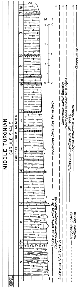
68.2 miles Middle part of Fairport exposed in roadside ditch on right. Inoceramus, Pseudoperna, Stramentum.
69.0 miles Middle part of Fairport exposed in small canyon on right. Inoceramus, Pseudoperna, reptile bones near road.
69.2 miles Cattle guard on left. Turn left (west) into pasture and follow old lease road. Fort Hays escarpment straight ahead. Blue Hill Shale Member of Carlile is approximately 215 feet thick in this bluff.
70.2 miles Cattle guard and gate. Pull onto faint trail on right just past cattle guard.
STOP 5. Lower half of Fairport Member, Carlile Shale. See graphic section (figure 19).
Figure 19--Graphic column of lower Fairport strata exposed on Crisler Ranch (STOP 5), SW SW sec. 28, T. 11 S., R. 16 W., Ellis County, Kansas. Section measured by Donald E. Hattin, 1959.
Turn around and retrace lease road to county road.
71.2 miles Cattle guard, turn left (north) on county road.
71.6 miles Roadcut and stream bank on right expose section from upper part of Jetmore to lower part of Fairport. Note ditch on hillside to left where Fencepost limestone was quarried.
71.7 miles Crossing Saline River.
72.8 miles Crossroad, proceed straight ahead.
73.3 miles Weathered Blue Hill Shale Member exposed in roadside ditch on right.
73.5-73.7 miles Weathered Fairport and high-level terrace gravel exposed in low roadcuts.
73.8 miles Road junction, turn left (west) and descend to lower level alluvial terraces of Saline River.
74.6 miles Road curves to north.
74.7 miles Sand and gravel of lower alluvial terrace exposed in roadbank on right.
75.1 miles Road junction. Turn left (west). For next half a mile route crosses lowest terrace of Smoky Hill River.
75.9 miles Terrace alluvium (sand, gravel) exposed in pit on left.
76.3 milesTerrace alluvium exposed in cuts on both sides of road.
76.4 miles Loessial soil in roadcut on right. High-level terrace alluvium exposed in pits at 10:00.
76.9 miles Terrace alluvium exposed in roadcut on left.
77.4 miles Crossing Saline River. Oil wells in vicinity are in Bemis-Shutts oil field. This field was discovered in 1928, has produced approximately 200 million bbls, and produces from the Arbuckle (Cambrian-Ordovician), Simpson (Ordovician), Kansas City-Lansing (Pennsylvanian) and Shawnee (Pennsylvanian).
77.6 miles Terrace alluvium exposed in roadcut.
78.7 miles Kaw Pipeline Company tank farm on right.
79.4 miles Crossroad, proceed straight ahead on Saline Valley Road.
79.6 miles High-level terrace alluvium exposed in low roadcut.
79.8 miles Middle part of Fairport exposed in ditch north of culvert (on right).
79.9 miles Exposure of high-level terrace alluvium.
80.0 miles High-level terrace alluvium exposed in small pit and roadcut on right.
80.1 miles View of low alluvial terrace ahead and to right. Floodplain on far right.
80.5 miles Lease road on left leading to Bemis oil field. Turn left onto Beach Ranch.
80.6 miles Cattle guard.
81.1 miles Blue Hill Shale Member of Carlile exposed in gullies on right. Exposure of Fort Hays Limestone Member straight ahead caps slump block.
81.5 miles Cattle guard.
81.8 miles Bridge.
81.9 miles "Y" in road. Turn right on secondary oil field road.
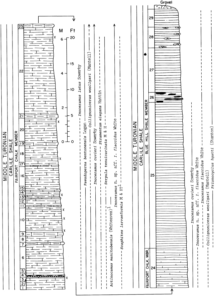
82.1 miles STOP 6. Upper half of Fairport Member and lower part of Blue Hill Member, Carlile Shale. See graphic section (figure 20).
Figure 20--Graphic column of upper Fairport and lower Blue Hill strata exposed Beach Ranch (STOP 6), in east 1/2 sec. 21, T. 11 S., R. 17 W., Ellis County, Kansas. Section measured by Donald E. Hattin, 1959. (1 These species known from single specimens.)
Retrace lease road to Saline Valley Road.
83.6 miles Junction of lease road and Saline Valley Road. Turn right (east) on latter. Proceed to crossroad at mileage 79.4.
84.7 miles Crossroad. Turn left (north) across Saline River.
85.0 miles Crossing Saline River. Note Fort Hays escarpment ahead.
85.4 miles Ascending to level of high alluvial terrace.
86.2 miles Note pediment surface to right and left.
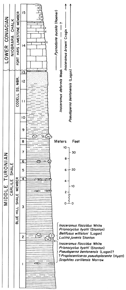
86.6 miles Base of King Hill. STOP 7. Upper half of Blue Hill Shale Member and full thickness of Codell Sandstone Member, Carlile Shale, overlain by lower half of Fort Hays Member, Niobrara Chalk. See graphic section (figure 21).
Figure 21--Graphic column of upper Blue Hill, Codell, and Fort Hays strata exposed at King Hill (STOP 7), NE sec. 3, T. 11 S., R. 17 W., Ellis County, Kansas. Section measured by Donald E. Hattin, 1959, 1964.
86.8 miles Re-board bus at top of hill and retrace route to lease road at Beach Ranch (mileage 80.5).
88.9 miles Crossroad just south of bridge across Saline River. Turn right on Saline Valley Road.
90.0 miles Lease road leading to Bemis oil field. Proceed straight ahead on Saline Valley Road through cut in loess on both sides of road and cross Saline River.
90.1 miles View of modern floodplain of Saline River on both sides of road.
90.5 miles Entrance to Beach Ranch. Occupied for four generations, since 1883, by the Bemis family, the ranch changed ownership recently.
90.8 miles Blue Hill Shale overlain by high-level terrace alluvium in roadcuts.
91.4 miles Pits in terrace alluvium on both sides of road.
91.5 miles Crossing Saline River.
91.8 miles View south to Fort Hays escarpment, with exposures of Blue Hill, Codell, and Fort Hays.
91.9 miles Crossing Saline River.
92.2 miles Crossing low terrace of Saline River.
92.4 miles High-level terrace alluvium on left, south of hilltop. View ahead to low terrace.
92.9 miles Descend from low terrace to floodplain.
93.1 miles Cross Saline River. Terrace alluvium overlain by loess in cut on left just west of bridge.
93.3 miles Crossing floodplain of Saline River.
93.6 miles Crossing Saline River.
94.6 miles Terrace alluvium in roadcut.
94.7 miles Crossing low terrace of Saline River for next 0.6 mile.
95.4 miles Junction of Saline Valley Road and US-183. Turn left (south) on US-183. To north, where US-183 ascends north bluff of Saline Valley, upper part of Blue Hill, Codell, and Fort Hays are exposed in deep roadcut.
95.6 miles Crossing floodplain of Saline River.
95.8 miles Crossing Saline River.
95.9-96.0 miles High-level terrace alluvium exposed poorly in roadcuts.
96.2-96.4 miles Loessial soil in roadcut. Ahead, road ascends Fort Hays escarpment. Oil wells in vicinity are part of Bemis-Shutts field.
96.9 miles Blue Hill shale overlain by (ascending) alluvium (chalky-limestone gravel), loess, and colluvium.
97.6-97.9 miles Upper part of Blue Hill, Codell, and lower part of Fort Hays in roadcuts on right. Note slumped rock.
98.2-98.3 miles Upper part of Blue Hill, Codell, and lower part of Fort Hays exposed in large roadcut on right. Normal fault near center of north part of cut has displaced Fort Hays downward (relatively) so that limestone lies opposite Codell. Low area between north and south parts of cut is a small colluviated valley with Fort Hays slumped to north at south side of old valley. Note channel-like structure near south end of cut.
98.4 miles Codell-Fort Hays contact exposed in roadcut on right.
98.5-98.7 miles Fort Hays Member exposed in cut on right. Fort Hays colluvium visible at north end of cut. Note river channel near south end of cut.
98.8-98.9 miles Fort Hays exposed in low roadcut. Ogallala Formation caps hill on west (right) side of highway.
99.5 miles Crossroad.
99.5-99.8 miles Ogallala Formation exposed in low roadcuts on both sides of road.
100.0 miles Smoky Hill Chalk Member of Niobrara Chalk exposed in low roadcut on left. Volviceramus grandis and Pseudoperna congesta.
100.5 miles Crossroad. For next several miles highway crosses upland surface of High Plains.
100.6-100.8 miles Ogallala Formation exposed in low roadcuts.
101.4 miles Ogallala Formation exposed in roadcut on left.
103.9 miles Weathered Fort Hays exposed in roadside ditch on right.
105.5-105.7 miles Fort Hays exposed in long low roadcut. Note soil profile developed at top of cut.
106.8 miles Loess exposed in low roadcut on left.
107.6-109.1 miles Much-fractured Fort Hays exposed in several roadcuts.
109.1 miles Descending Fort Hays escarpment.
110.0 miles I-70 overpass at north edge of Hays, Kansas. Dinner in Hays. After dinner, proceed to Oakley, Kansas for overnight stop.
Figure 22--Map showing route of second day of field trip (April 14, 1978). Geology modified from Geologic Map of Kansas (1964).
0.0 miles Junction of U. S. 40 and U.S. 83, Oakley, Kansas. Proceed westward on US-40. For next 27 miles, route crosses loess-veneered upland surface of High Plains.
8.3 miles Entering Monument, Kansas.
15.9 miles Entering Page City, Kansas.
17.8 miles Junction: K-25 turns south. Proceed straight on US-40.
18.4-18.6 miles Loess exposed in roadcut on left.
21.1 miles Entering Winona, Kansas.
23.5-23.6 miles Loess exposed in roadcut on left.
25.1-25.4 miles Loess exposed in roadcut on right.
25.6-25.8 miles Loess exposed in roadcut.
26.5-26.7 miles Loess exposed in roadcut on right. McAllaster Buttes on horizon at 11:30.
27.1-27.3 miles Sharon Springs Shale Member of Pierre Shale, overlain by loess, exposed in roadcut. Excellent exposure of the Sharon Springs in pasture north of highway.
27.6 miles Crossing North Fork of Smoky Hill River.
28.3-28.5 miles Stratified Pleistocene sand and gravel (Crete Formation) overlain by loess (Loveland Formation) in roadcut. McAllaster Buttes at 1:00.
29.9 miles Entering McAllaster, Kansas.
30.2 miles Dirt road on right. Turn right.
30.3 miles Junction, dirt road and abandoned US-40. Turn right on old US-40 and enter pasture through wire gate.
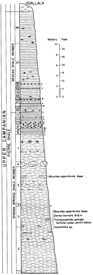
31.3 miles North side of McAllaster Buttes. STOP 8 (figure 23). Walk across pasture to extensive exposures of Pierre Shale.
Figure 23--Graphic column of Sharon Springs and Weskan strata exposed at McAllaster Buttes (STOP 8), SE sec. 13, T. 12 S., R. 37 W., Logan County, Kansas. Section measured by James E. Gill, U.S. Geol. Survey. Numbering corresponds to published section by Gill, Cobban and Schultz (1972, p. 40).
Proceed eastward to old US-40.
31.9 miles Crossroad. Turn right (south) on county road.
32.8 miles Junction county road and US-40. Cross US-40 and proceed south on Logan County Highway 391.
33.1 miles Pierre Shale exposed in low roadcut on right.
33.3-33.5 miles Loess exposed in roadbank on left. For next several miles route crosses upland surface of High Plains
36.5-36.7 miles Loess exposed in roadcut on left.
36.8 miles Loess exposed in roadbank on right.
38.0 miles Valley of Smoky Hill River marked by line of trees ahead.
38.5 miles Margin of low alluvial terrace.
39.2 miles Crossing Smoky Hill River, which is an intermittent stream in this area.
39.4 miles Upper part of Smoky Hill Chalk Member of Niobrara Chalk exposed in roadcuts. Chalk is overlain by sand, gravel, and loess of alluvial terrace. Note exposures of weathered Smoky Hill in bluffs on right at 2:30.
39.5 miles Smoky Hill overlain by thin loess veneer exposed in low roadcut.
39.9 miles Junction Logan County Highway 391 and K-25. Turn left (east) on K-25.
40.1 miles Pierre Shale exposed in small fault block and overlain by loess.
40.4 miles Crossing low alluvial terrace of Smoky Hill River.
41.0 miles Terrace alluvium overlain by loess-like silt exposed in roadcut on right.
41.2 miles Sloping surface on right is a flanking pediment.
41.3-41.4 miles Smoky Hill Chalk Member exposed in roadcut and mantled by loess. Chalk contains Platyceramus and Pseudoperna.
41.6 miles Loess and terrace alluvium exposed poorly in cut on right.
41.9-42.1 miles Terrace alluvium exposed poorly in roadcut.
42.2 miles Crossing low alluvial terrace.
42.3 miles Smoky Hill Chalk Member exposed ahead and to left in cliffed bluff overlooking valley of Smoky Hill River. Note anomalous dips owing to flexure. Brilliant coloration of weathered chalk is common in upper part of Smoky Hill Member.
42.8-43.1 miles Smoky Hill Chalk Member, Pierre Shale, and loess exposed in long, deep roadcut. Normal fault at mile 43.0 dropped Pierre to level of Smoky Hill Member. Pierre overlain by thick deposit of loess.
43.3 miles Erosional pillar of Smoky Hill in pasture on right.
43.6 miles Gullied alluvial terrace on left.
43.8 miles Terrace alluvium exposed in arroyo on right. Just east is roadcut in loess overlain by alluvium (sand) of high-level terrace. Note buried soil (dark) within loess.
44.0 miles Note relatively steep dip in exposure of Smoky Hill Member in bluff of Smoky Hill River at 10:00.
44.1 miles Weathered Smoky Hill overlain by (ascending) loess and terrace alluvium (sand), all exposed in roadside ditch on right. Note buried soil (dark) in loess.
44.4 miles Terrace alluvium (sand), and silt (probably loess), exposed in low roadcut.
44.8-44.9 miles Smoky Hill Chalk Member, Pierre Shale and loess, exposed in roadcut. Pierre slope littered with large selenite crystals.
45.2 miles Loess exposed in roadcut on right.
45.5 miles Crossing low alluvial terrace of Smoky Hill River.
47.9 miles Junction K-25 and Logan County Highway 407. Proceed on K-25.
48.8 miles Smoky Hill Chalk Member exposed in bluffs on right at 2 o'clock.
48.9 miles Smoky Hill veneered by colluvium of small flanking pediment in low roadcut.
49.2 miles Smoky Hill Chalk Member and overlying alluvium well exposed in arroyo on right. Cap rock on cliff is weathered Smoky Hill.
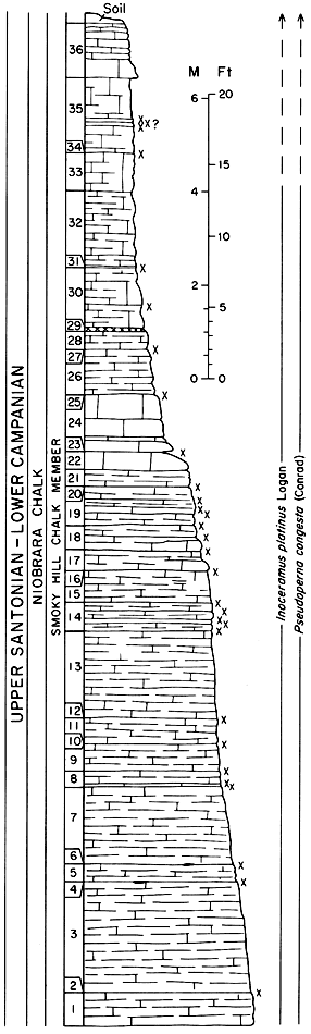
49.5 miles Top of small rise; pull onto small ramp on right. STOP 9 (figure 24). Cuts directly ahead are terrace gravel and sand veneered by colluvium of flanking pediment developed around badlands (Goblin Hollow) that comprise STOP 9. In 1965 a modern bison skull was discovered in this colluvium. Walk south from road into badlands through section in upper part of Smoky Hill Member.
Figure 24--Graphic column of Smoky Hill strata exposed at Goblin Hollow (STOP 9), E 1/2 sec. 27, T. 12 S., R. 35 W., Logan County, Kansas. Section measured by Donald E. Hattin and Gary F. Stewart, 1965.
Re-board bus and proceed eastward on K-25.
49.7-49.8 miles Smoky Hill Chalk Member, overlain by terrace gravel, sand, and silt, exposed in roadcut.
49.9 miles Junction, K-25 and county road. Turn sharp right (south) on county road. Town visible on left at junction is Russell Springs, former seat of Logan County. Like other towns along Smoky Hill River, Russell Springs declined in importance because the railroad and US-40, a major transcontinental route, were built not along the river course, but to the north, on an interstream divide. The early stage and wagon route, however, did follow the river.
50.7 miles Junction of county roads. Turn left (east).
51.4 miles Steep hill. Road descends to level of Quaternary alluvium in small tributary to Smoky Hill River.
51.7 miles Crossroad. Turn right (south) on county road. For most of next 18 miles route traverses upland surface of High Plain.
52.6 miles Small exposures of Smoky Hill Member in pasture on left (east).
54.7 miles Side road left. Proceed straight ahead. Brilliantly colored cliff in distance ahead and to left is much-weathered Smoky Hill chalk, in upper third of member, along south bluff of Twin Butte Creek.
56.7 miles Junction of county roads. Turn left (east).
58.7 miles Side road left. Proceed straight ahead on High Plains surface.
61.7 miles Crossroad. Proceed straight ahead.
64.7 miles Side road left. Proceed straight ahead.
67.2 miles Road curves to right (south). Exposures of Smoky Hill Member visible at left of road and on distant side of Smoky Hill River.
67.7 miles Road curves to left (east). View ahead (1:00 to 2:00) of large badlands in Smoky Hill.
68.2 miles Road curves to right (south).
69.2 miles Road curves to left (east).
70.2 miles Road curves to right. Turn left onto unimproved ranch trail, keeping fence on left.
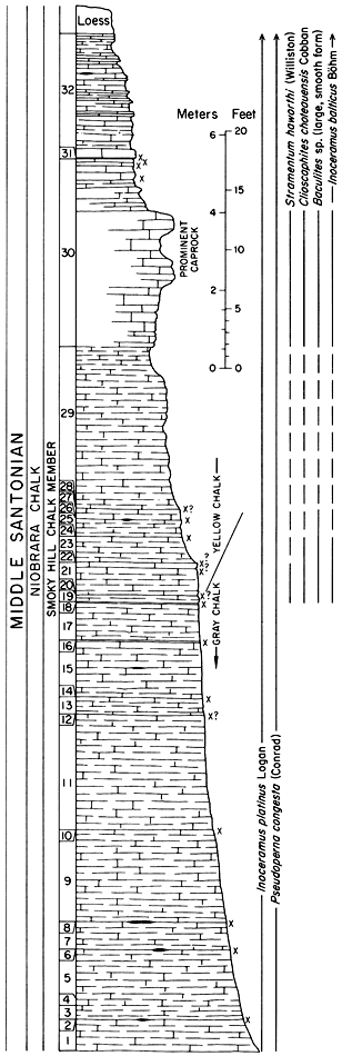
70.8 miles Gap in fence line. STOP 10 (figure 25). Walk north to badlands that expose middle part of Smoky Hill Chalk Member.
Figure 25--Graphic column of Smoky Hill strata exposed at Chalk Bluff (STOP 10), SW sec. 25, T. 14 S., R. 33 W., Logan County, Kansas. Section measured by Donald E. Hattin and Philip H. Heckel, 1965.
Turn around and retrace trail to county road.
71.4 miles Junction trail and county road. Proceed south on county road.
71.9 miles Junction of county roads. Turn left (east) on Logan County Highway 474.
73.0 miles Smoky Hill exposed in badlands on right.
74.3 miles Loess exposed in roadcut.
74.4 miles High-level terrace alluvium (gravel) exposed in roadcut.
75.0 miles Bridge across Ladder Creek.
75.3 miles Junction Logan County Highway 474 and US-83. Turn left (north) on US-83.
75.8 miles Remains of Elkader, Kansas.
76.0 miles Bridge across Smoky Hill River.
76.2 miles Crossing low alluvial terrace of Smoky Hill River. Note stone post on right, marked B.O.D. 1865. This and several similar posts on other well-traveled north-south roads in the area mark the Smoky Hill Trail and route of the Butterfield Overland Dispatch, a stageline that served Smoky Hill River county from June, 1865 to March, 1866. The line was then sold to Holiday Overland and Express Company, and finally to The Wells Fargo & Co. Indian attacks and railroad construction to the north terminated stageline operations.
76.4-76.6 miles Smoky Hill Member, overlain by high-level terrace gravel, in roadcuts and natural exposures.
76.7-76.8 miles Smoky Hill Member exposed in low roadcut. Alluvium, overlain by pebbly silt (colluvium), exposed in roadcut ahead on right.
77.7 miles Loess exposed in roadcut on right. Badlands cut into Smoky Hill Member in draw on left.
78.4 miles Abandoned schoolhouse on left. Road to right at large sign leads to erosional features in Smoky Hill Member known as "Monument Rocks" and "Sphinx."
79.0 miles Smoky Hill Member well exposed in miniature badlands on right.
79.1 miles Unconformity between Smoky Hill Member and Pleistocene loess exposed in roadcut on right.
79.2 miles Bridge across draw.
80.0 miles Smoky Hill Member exposed in many places in large draw on left.
81.2 miles Smoky Hill Member exposed in draw on right at 4:00.
81.7 miles Loess exposed in roadcut on right.
82.0 miles Side trail on right. Smoky Hill Member exposed in draw on both sides of highway.
83.2 miles Loess exposed in roadcut on right.
84.3 miles Bridge. Loess exposed in roadcut just south of bridge.
87.2 miles Crossroad. Proceed on US-83.
89.2 miles Ogallala Formation exposed in draw on right.
89.7-89.9 miles Ogallala Formation, overlain by Pleistocene alluvium (sand) and loess, exposed in deep roadcut.
90.0 miles Bridge.
90.8 miles Crossing loess-veneered upland surface of High Plains from here to Oakley.
92.9 miles Alluvium (sand), overlain by loess, exposed in roadcut. Ogallala Formation exposed in draw on left.
94.9 miles Loess exposed in roadcut.
97.6-97.7 miles Loess exposed in roadcuts.
97.9 miles Junction US-83 and US-40 at Oakley. Turn right (east) on US-40. From here to Voda exit route crosses loess-veneered upland surface of High Plains.
99.7 miles Roadside park.
99.9 miles Entering Gove County.
100.0 miles Junction US-40 and I-70. Turn right onto eastbound ramp of I-70.
120.1 miles Roadside park on I-70.
130.8 miles Loess exposed in roadcut on right.
135.0 miles Loess exposed in roadcut on right.
136.3 miles Entering Trego County.
138.8-139.1 miles Loess exposed in roadcut on right.
140.9 miles Loess exposed in roadcut on left.
141.6-141.9 miles Loess exposed in roadcut.
142.9 miles Voda interchange. Turn right onto exit ramp.
143.0 miles Stop sign. Turn right (south) on Voda Road.
145.1 miles Pleistocene alluvium and loess exposed in roadcut on left. Prominent buried soil (dark) about halfway between top and base of cut. Conspicuous filled burrow lies in and below soil zone. Irregular-shaped calcareous nodules abundant in zone below soil. Colluvium and scattered blocks of Ogallala lie at top of cut.
145.7 miles Bridge across intermittent stream.
145.8 miles Ogallala Formation exposed in roadside ditch on right and in graded bank on left.
145.9 miles Roadcut in sand and gravel deposit derived from Ogallala Formation, which closely underlies upland surface in distance on right.
152.4 miles Junction Voda Road and Trego County Highway 458. Proceed on Voda Road.
156.4 miles Junction Voda Road and Trego County Highway 462. Proceed on Voda Road.
156.7 miles View ahead to valley of Smoky Hill River.
157.0 miles Top of bluff overlooking valley of Smoky Hill River. Smoky Hill Member exposed in roadcut on left.
157.3-157.4 miles Fort Hays Member, overlain by colluvium, exposed in roadcuts on left.
157.5 miles Upper part of Blue Hill Shale Member, Codell Sandstone Member, and lower part of Fort Hays Limestone Member exposed in roadcut on left. STOP 11 (figure 26).
Figure 26--Graphic column of upper Blue Hill, Codell, and Fort Hays strata exposed on Voda Road, on north bluff of Smoky Hill River (STOP 11), NW sec. 29, T. 14 S., R. 24 W., Trego County, Kansas. Section measured by Donald E. Hattin and Gary Stewart, 1965.
157.6 miles Intermediate-level alluvial terraces of Smoky Hill River visible on left.
157.7 miles Floodplain of Smoky Hill River. Low-level terrace can be seen at right and right rear. Cross Smoky Hill River.
157.9 miles Crossing margin of one of intermediate-level terraces. Blue Hill Shale Member exposed poorly in roadside ditch on right, beneath terrace alluvium. Note large septarian concretions in pasture on right.
158.0 miles Terrace alluvium exposed in roadside ditch and roadbank on right. Note gravel pit in pasture on left. Pit is in the next-to-highest of four terraces that can be readily distinguished on the south side of the river at this point.
158.3 miles Alluvial sand of high-level terrace exposed in roadcut on right.
158.4 miles Crossroad. Turn right (west). For next 1.4 miles, route crosses surface of highest terrace of Smoky Hill River. Gently arched Fort Hays strata visible in bluff on north side of Smoky Hill River, on right.
160.1 miles Fort Hays Member exposed in roadside ditch and pasture on right.
160.3 miles Fort Hays Member, overlain by terrace alluvium, exposed in roadside ditch on right.
160.4 miles "T" intersection. Turn right (north). Fort Hays exposed in pasture and along road on right.
160.6-160.8 miles Crossing low terraces and floodplain of Smoky Hill River. Cross Smoky Hill River.
160.9 miles Stop on north side of river. Cross fence and walk eastward to bluff at confluence of Hackberry Creek and Smoky Hill River.
STOP 12 (figure 27). Party will examine section along cliffs extending upstream for one-half mile along Hackberry Creek and in badlands above the cliffs.
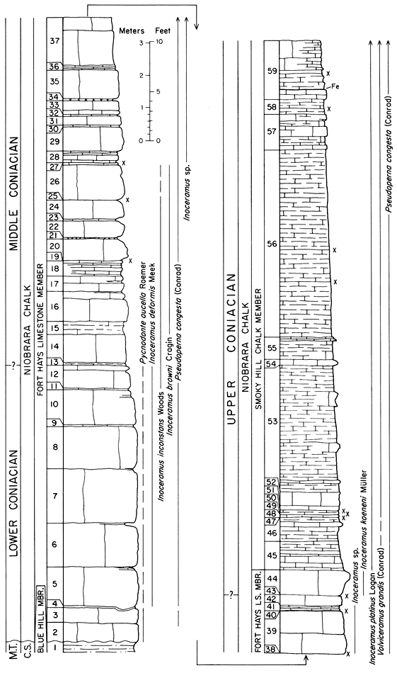
Figure 27--Graphic column of rocks exposed at mouth of Hackberry Creek (STOP 12, O'Toole Ranch), SW sec. 24 and NW sec. 25, T. 14 w., R. 25 W., Trego County, Kansas. Section measured by Donald E. Hattin, and Craig Hatfield, 1962. C.S. = Carlile Shale; M.T. = Middle Turonian.
Follow ranch trail to wire gate. Cross fence and follow road south to waiting bus.
160.9 miles Re-board bus and retrace route to Voda Road.
161.4 miles County road junction, turn left (east).
163.4 miles Junction of county road and Voda Road. Turn right (south) on Voda Road. Proceed to Garden City (dinner), Wichita (for plane connections) and Oklahoma City.
Kansas Geological Survey, Upper Cretaceous Stratigraphy and Depositional Environments of Western Kansas
Placed on web July 9, 2009; originally published in April 1978 (reprinted 1987).
Comments to webadmin@kgs.ku.edu
The URL for this page is http://www.kgs.ku.edu/Publications/Bulletins/GB3/02_roadlogs.html