Kansas Geological Survey, Chemical Quality Series 10, originally published in 1981
Next Page--Appendix
Originally published in 1981 as Kansas Geological Survey Chemical Quality Series 10. This publication is also available as an Acrobat PDF file (12 MB).
Groundwater resources play a vital role in the livelihood and economy of central and western Kansas. Decline of water tables and realized or potential water-quality problems in some areas serve as reminders that these fresh-water resources are part of a dynamic system that is subject to change. A consideration of water quality, in addition to data on groundwater quantity and availability, is becoming increasingly important for resource management decisions. Indeed, water quality becomes a dominant factor in parts of south-central Kansas.
Brines produced in both development and operation of oil and gas fields and from dissolution of salt contained in bedrock units serve as potential sources for groundwater degradation in the Equus beds. The areal extent of the oil and gas fields and the common use in the past of evaporation ponds for brine disposal suggest the need for a chemical-quality monitoring network of wells throughout the Equus beds area. The oil-field brine contamination area near Burrton appears not to have produced significant changes in water quality for wells in the Wichita well field area. However, irrigation well sites exist north of the Arkansas River, where an influx of subsurface brine is indicated. Poorer water quality is also noted in the Arkansas River Valley.
Other areas covered by this series of studies are Greeley, Wichita,, Scott, Lane, and southern Wallace counties (Kansas Geological Survey Chemical Quality Series 2); Hamilton, Kearny, Finney, and northern Gray counties (Chemical Quality Series 4); Stanton, Grant, Haskell, Morton, Stevens, Seward, Meade, and southern Gray counties (Chemical Quality Series 6); Ford County and the Great Bend Prairie--Kiowa, Edwards, Pratt, Kingman, Stafford, Barton, Rice, and Reno counties (Chemical Quality Series 7); and Cheyenne, Sheridan, Graham, Logan, Gove, and northern Wallace counties (Chemical Quality Series 8).
Wet-weather conditions in the Equus beds area during the scheduled sampling period in July 1979 limited sample collection to four irrigation wells. Water samples from an additional 41 irrigation wells were obtained in August 1979. The limited amount of pumpage of these systems prior to sampling in 1979 suggested the need for further sampling before evaluating the chemical quality of irrigation waters in the Equus beds region. In July 1980, water samples were obtained from 110 pumping irrigation wells and from tail-water pits associated with six of those wells.
Groundwaters from the portion of the study area north of the Little Arkansas River are predominately calcium-bicarbonate in character. Sodium-chloride-type waters are found locally in the Arkansas River Valley, and a gradation from these sodium-chloride waters toward the calcium-bicarbonate-type waters is noted for the region between the Arkansas and Little Arkansas rivers. Locally high chloride values within the Equus beds area reflect contamination of the fresh-water aquifer by natural processes or human activity.
This study is the sixth and final part of a program established in 1974 to obtain a chemical-quality data base for irrigation waters from the major unconsolidated aquifer systems of western Kansas., Locations of the present and previous study areas (Hathaway and others, 1975, 1977, 1978a, 1978b, 1979) are illustrated in Figure 1. A small overlap exists in east-central Reno County between the present study and the sampling program carried out in 1977 in the Great Bend Prairie area. A generalized location map of the present study area is provided in Figure 2. Wells sampled during this study fall within the region covered by the Equus Beds Groundwater Management District #2.
Figure 1--Map showing coverage of this report and related past reports in this Series.
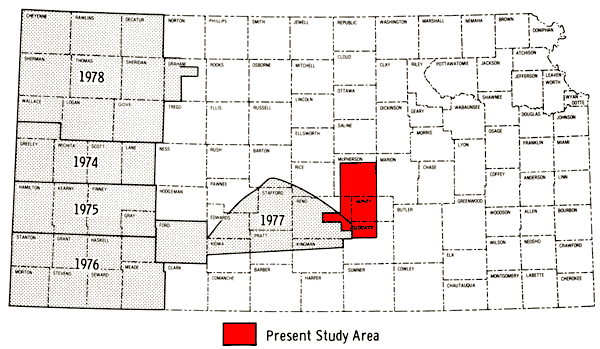
Figure 2--Location of the study area.
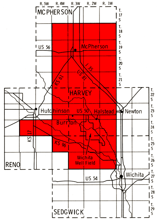
Irrigation, domestic, and municipal wells in the Equus Beds area derive water primarily from unconsolidated Pliocene and Pleistocene age deposits, which are covered by alluvial deposits in the major drainage systems (Williams and Lohman, 1949; Lane and Miller, 1965; Stramel, 1967). These deposits attain a maximum thickness in a north-south-trending buried valley (McPherson Channel) in McPherson, Harvey, and northern Sedgwick counties and in the southeasterly trend- ing Arkansas River Valley of Reno and Sedgwick counties (Bayne and ward, 1967). The 55 wells of the Wichita municipal well field in southwestern Harvey and northwestern Sedgwick counties represent an important localized area of ground- water withdrawal in the southern portion of the present study area.
Previous investigations of the Equus beds area indicate the chemical quality of surface and groundwaters varies widely. It has been noted that water in the Arkansas River is generally of poor quality, and that water from the Little Arkansas River is of poorer quality than groundwater in the Equus Beds (Stramel, 1956). A similar trend was also observed for the chemical quality of groundwaters from the alluvial valleys of these rivers. However, groundwaters from other parts of the Equus beds were found to be of relatively good chemical quality, except in local areas where contamination by brines has occurred (Williams and Lohman, 1949).
Historical chemical-quality data for groundwater from wells in the study area are most plentiful for municipal well systems such as the Wichita well field. However, information pertaining to irrigation wells throughout the Equus beds area is much more limited. Historical data, other than that derived through the Kansas Geological Survey's Chemical Quality of Irrigation Waters program, were found for only 13 of the 110 wells sampled for the present study in 1980.
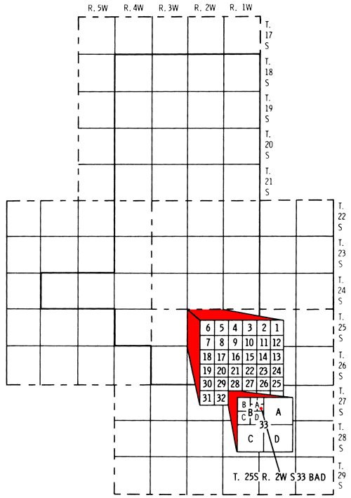
Well locations used in this report are based upon the Bureau of Land Management numbering system. The location is composed of the township, the range, and the section, followed by letters designating the subdivision of the section in which the well is located (Fig. 3).
Figure 3--Illustration of the Bureau of Land Management nunbering system used for well locations in this report.
Discussions of the geologic and hydrologic features of the area covered by this report are provided in a number of Kansas Geological Survey reports (Haworth and Beede, 1897; Moore, 1940; Lohman, 1940; Williams and Lohman, 1949; Stramel, 1956, 1967; Bayne, 1956; Lane and Miller, 1965; and Leonard and Kleinschmidt, 1976). Additional geohydrologic information pertaining to the study area is provided by Gogel (1981). Discussions of the Pleistocene drainage history of the study area are also found in Fent (1950) and Frye and Leonard (1952). Adams (1903), Schoewe (1949), Frye and Leonard (1952), and Frye and Schoewe (1953) discuss the physiographic subdivisions of Kansas and also provide a general overview of the topographic features of the study area.
The present study area falls within the Great Bend physiographic region as defined by Frye and Schoewe (1953). The surface of the Great Bend region coincides with an eastward projection of the High Plains surface, making the placement of this region into either the Great Plains or Central Lowlands physiographic province problematic. However, on the basis of geohydrologic similarities, Moore (1940) placed the Equus beds, the Great Bend Prairie area, and western areas of the State underlain by the Ogallala Formation into a common western Kansas groundwater region.
The surface topography of the study area is mainly that of a plain whose surface is modified by the presence of low sand dunes, shallow depressions, and the southeasterly trending Arkansas and Little Arkansas rivers. The major sand-dune occurrence in the study area is in a region between Burrton and the Little Arkansas River in Harvey County. This area represents the eastern terminus of a belt of sand dunes that extend northwestward along the southern margin of the Little Arkansas River Valley into Rice County. Williams and Lohman (1949) considered these sand dunes to provide a high rate of recharge (from infiltration of precipitation) to the Equus beds in the area near the Wichita well field. However, Stramel (1967) suggests that the presence of a substantial silty-clay zone (Sappa Formation) underlying the dunes in this area would impede recharge of the deeper aquifer zones, with ultimate loss of most of this infiltration water to the Little Arkansas River.
Evidence of subsidence of the land surface in the Equus beds area is most apparent along the western side of the McPherson Channel. A linear trend of sink holes and undrained depressions exists from a point northeast of Conway southward to Colwich. Many of these features predate heavy pumpage for oil and water in the area; however, active subsidence continues today. The development of the surface subsidence features in the Equus beds area has been ascribed to dissolution of salt and gypsum from underlying Permian-aged units (Leonard and Kleinschmidt, 1976).
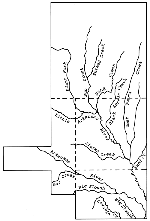
Surface drainage in the study area is provided by the Arkansas River, Little Arkansas River, and their tributary systems. Both rivers have a southeastward trend in the study area, with the Little Arkansas River joining the Arkansas River just south of the study area. The Little Arkansas River is generally a gaining stream in the study area, with water being discharged from the aquifer to the stream (Stramel, 1967). The Arkansas River appears to be nearly in equilibrium with the aquifer system in the study area, neither gaining from nor losing to it (Lane and Miller, 1965). Recent observations made on these two river systems indicate that their hydrologic behavior in the study area is generally the same as that noted in 1967 (J. Gillespie, personal communication, 1981). A topographic high in the northern part of the study area serves as a surface-water divide for drainage in northern McPherson County. The area north of this divide is drained by the Smoky Hill River, a part of the Kansas River system. The principal surface drainage features of the study area are depicted in Figure 4.
Figure 4--Drainage systems of the study area.
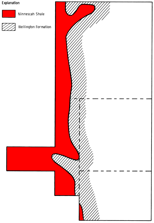
The bedrock floor underlying the unconsolidated deposits in the study area consists primarily of units of early Permian age, the Wellington Formation and the Ninnescah Shale. The Wellington Formation is the predominant bedrock unit of the area. It is overlain by the Ninnescah Shale near the western boundary of the study area (Fig. 5). In the northeastern corner of the study area the Kiowa Shale, Cretaceous age, underlies the unconsolidated deposits (Williams and Lohman, 1949).
Figure 5--Generalized bedrock map showing the contact between the Wellington Formation and the Ninnescah Shale in the study area.
Gogel (1981) indicates the presence of a groundwater divide in the unconsolidated aquifer just south of the Conway-McPherson area, which generally appears to coincide with the observed surface-water divide. North of the divide, groundwaters flow northward toward the Smoky Hill River Valley. South of the divide, groundwaters appear to flow south and eastward toward the Little Arkansas River. In the study area south of the Little Arkansas River groundwater flows in an east-southeasterly direction. Depth to water in the study area varies from about 100 feet in the area north of McPherson to less than 10 feet in the Arkansas River Valley.
The Wellington Formation, which dips gently westward and southwestward, can be divided into three members in the subsurface of eastern Reno County. The lower member (Anhydrite member) consists mainly of gray shale and anhydrite. The middle member (Hutchinson Salt Member) consists of about 350 feet of salt interbedded with shale and anhydrite. The upper member consists primarily of gray shale with lesser amounts of gypsum, anhydrite, dolomite, and siltstone (Leonard and Kleinschmidt, 1976).
The dissolution of salt and anhydrite from the Wellington Formation, followed by collapse of the upper shale member and subsidence of the overlying deposits, has influenced the depositional pattern of Pleistocene streams in the study area. This collapse zone that has developed in the Wellington Formation is a highly permeable interval in the Equus beds area. Drillers have commonly called this interval the "lost-circulation zone"; Gogel (1981) also refers to this zone as the Wellington aquifer. The Wellington aquifer trends north-south, generally paralleling the Wellington Formation-Ninnescah Shale contact in the western portion of the study area. Downward leakage of fresh water from the overlying unconsolidated deposits into the Wellington aquifer continues to promote the dissolution of salt and anhydrite, with subsequent westward progression of the system and surface subsidences.
The Wellington aquifer in the Equus beds area has served as a source of brine for secondary oil-recovery operations, for industrial chemical feedstock, and for recovery of liquid hydrocarbons stored in man-made cavities in the Hutchinson Salt Member. The system has also been used as a means for disposal of oil-field brines (Leonard and Kleinschmidt, 1976).
Figure 6 is a general soil association map of the study area. This map has been produced by combining data for individual counties covered by this report. Some grouping of the various soil associations presented on county soil maps and some regrouping of mapping units to better reflect the proportional pattern of soils in natural landscapes for a multi-county area was necessary (Hoffman and Dowd, 1974; Penner and Wehmueller, 1979; Rockers and others, 1966; Rott, in press).
Figure 6--Soil association map of study area.
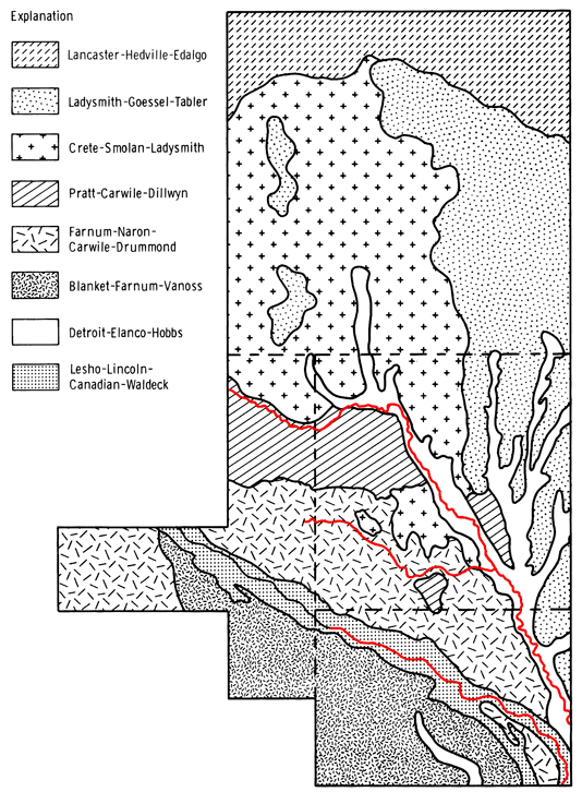
Favorable climatic conditions (mean annual temperature of ~57° F and mean annual precipitation of ~30 inches) have allowed the formation of deep soil profiles in the study area, except where otherwise noted. Most of the soils with a clayey subsoil are either moderately well drained or somewhat poorly drained. The Little Arkansas River serves to divide soils in the study area into two broad groups. Soils north and east of the river are predominately clayey and loamy with well-developed surface drainage features. South and west of the river, soils tend to be sandy and loamy with poorly defined surface drainage features. Brief descriptions of the soil association groups used in this report are given in Table 1.
Table 1--Soil Associations of the Equus Beds Area
|
Groundwater samples were collected from 110 pumping irrigation wells over a three day period, July 28-30, 1980. Water samples were also obtained from tail-water pits associated with six of the irrigation wells. A similar sampling program in July 1979 was cancelled after the collection of samples from four wells because of wet weather conditions that resulted in many of the irrigation systems being shut down during the sampling period. Water samples from 41 irrigation wells in the Equus beds area were obtained from John Yost, Halstead, in August 1979. Thirty-five of the 45 wells from 1979 were resampled during the 1980 sampling program. Overlap of the Great Bend Prairie study area (1977) with the Equus beds study area (1980) resulted in the resampling of three wells from the earlier study. Historical data prior to 1979 were found for about 15 percent of the wells sampled in 1980.
The 1980 sampling program produced 15 duplicate sets of samples, resulting from individual field personnel's collection of two consecutive sets of samples from wells within their sampling area (Individual Duplicate Sets). Another group of six duplicate sets of samples was obtained by having two different field crews collect samples from wells located along boundaries of the different sampling areas (overlap Duplicate Sets). Five of the Overlap Duplicate sites also corresponded to Individual Duplicate sites. Time intervals between collection of Overlap Duplicate sets varied from part of one day to one day.
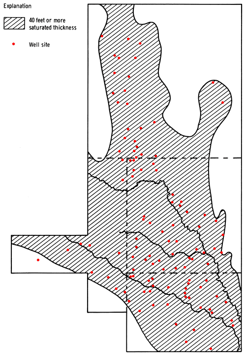
Figure 7 shows the locations of wells sampled during the 1980 sampling program. The thickness of the saturated unconsolidated sediments underlying these wells is generally 40 feet or greater (Bayne and Ward, 1967). The areal distribution of the sampling sites in McPherson and northern Harvey counties reflects the present state of irrigation development in this area. The frequency of irrigation wells in this area is greater in the region overlying the McPherson Channel than in that part of the study area that is comprised of southeastern McPherson and north-central Harvey counties. The sand dune area north of Burrton, water-quality problems in the Burrton area, and the well distribution noted above effectively serve to divide the sampling sites into a northern group and a southern group.
Figure 7--Well locations for 1980 sampling program and a generalized display of areas having 40 feet or more of saturated thickness.
Sample-handling procedures and analytical methodologies for the 1980 sampling program were generally the same as those described earlier (Hathaway and others, 1979). Field measurements of water temperature, pH, and specific conductance were made at the time of sample collection. Determinations of carbonate (CO3) and bicarbonate (HCO3) levels were made using an auto-titrimeter at a field laboratory established in Halstead, Kansas. Measurements of pH were also made on the samples at the field laboratory in the course of the CO3-HCO3 analyses. All other work was performed at the Kansas Geological Survey laboratories.
Fluoride (F) analysis was by ion-selective electrode. Chloride (Cl), sulfate (SO4), and phosphate (PO4) determinations employed Technicon Auto-Analyser II systems. Nitrate (NO3) levels were determined by ultra-violet absorption spectroscopy. A Jarrell-Ash Atom Comp inductively coupled argon plasma emission spectrometer (ICP) provided the means of analysis for silica (SiO2 calcium (Ca), magnesium (Mg), sodium (Na), potassium (K), strontium (Sr), iron (Fe), manganese (Mn), and boron (B). Copper (Cu) determinations were made by graphite-furnace atomic absorption spectroscopy.
A one-liter unacidified sample (for major constituents) and a 250 ml acidified sample (for NO3 and PO4) were collected at each of the six tail-water sites. The sample for NO3 and PO4 was collected into a pre-acidified bottle and filtered upon returning to the Kansas Geological Survey laboratories. This procedure may result in the release of PO4 from suspended sediment in the sample, but probably reflects the potential available PO4 levels of these waters should they be recycled back into the fields. The same set of samples was collected at each well site, with the 250 ml acidified sample also being used for trace element determinations.
Groundwater samples obtained from wells in the Equus beds area in 1979 were refrigerated after collection and were packed in ice during their return to the Kansas Geological Survey laboratories. All analyses of these samples were performed at the Survey's laboratories using the same procedures employed on samples from the 1980 program.
Standard deviations for determinations of selected constituents for the two different duplicate sets of samples from the 1980 sampling program are presented in Table 2. The similarity of the standard deviations for the two sets of duplicate samples probably reflects the short time interval involved in the collection of samples in the Overlap Duplicate group, making them appear more like Individual Duplicate sets.
Table 2--Standard Deviations of Data for Duplicate Sets, 1980
| Determination | Individual Duplicate Sets ±σ |
Overlap Duplicate Sets ±σ |
|---|---|---|
| SiO2 | 0.7 ppm* | 0.7 ppm* |
| Ca | 0.8 ppm | 1.6 ppm |
| Mg | 0.4 ppm | 0.6 ppm |
| Na | 2.2 ppm | 2.4 ppm |
| K | 0.2 ppm | 0.2 ppm |
| Sr | 0.02 ppm | 0.01 ppm |
| HCO3 | 0.4 ppm | 0.9 ppm |
| SO4 | 1.5 ppm | 2.6 ppm |
| Cl | 2.1 ppm | 2.4 ppm |
| F | 0.00 ppm | 0.04 ppm |
| NO3 | 0.2 ppm | 0.3 ppm |
| PO4 | 0.03 ppm | 0.02 ppm |
| Fe | 32 ppb** | 17 ppb** |
| Mn | 10 ppb | 8.7 ppb |
| Total solids | 11 ppm | 6.8 ppm |
| Specific Conductance (Lab) |
11 pmho*** | 25 pmho*** |
| *parts per million or milligrams per liter **parts per billion or micrograms per liter ***micro-mhos at 25° C ±σ = √ [(1/2 ∑i=1Nri2) / N] ri = range of analysis of sample pairs N = number of sample pairs |
||
A comparison of waters from tail-water pits and associated wells is presented in the Results and Discussion section of this report. A general compilation of the chemical-quality data for irrigation waters collected in the 1980 sampling program is presented in Appendix A by county and location.
The 40-foot saturated thickness contour of Kansas Geological Survey Map M-5 (Bayne and Ward, 1967) was used in this report as a general boundary for the presentation of areal chemical-quality data of the 1980 sampling program. The areal extent of selected soil associations, especially of those in the Arkansas River Valley, was also used as a general guide in mapping the chemical-quality data. 1979 data from well sites not resampled in the 1980 sampling program were also included to enhance the coverage in the study area. A comparison of the data for well sites covered by sampling in both 1979 and 1980 suggests that the data are indistinguishable within the concentration range intervals used for mapping of the data in this report. A lack of reasonably uniform sample coverage throughout the portion of the study area having more than 40 feet of saturated thickness, the observed variations in water quality, and uncertainties in water quality arising from the presence of several oil and gas fields have necessitated a discontinuous mapping of the chemical-quality parameters within this region of interest.
The specific conductance of a water sample is a measure of the sample's ability to conduct an electrical current. This ability increases with increasing concentrations of dissolved salts, and is generally reflected by an increase in specific conductance values. Thus, an areal display of specific conductance data (Fig. 8) for irrigation waters from the study area provides general insight into the present chemical-quality status of groundwaters in this portion of the Equus beds. It should be noted that the data used to produce the chemical-quality maps in this report are based on waters being produced by existing, active irrigation wells in the study area. However, the extent to which each well provides a truly representative, integrated sample of the entire water column of the aquifer at each site is largely unknown. Wells in a given area that are screened in the upper portion, the lower portion, or in all producing zones of the aquifer can probably be expected to produce water of somewhat different quality. Therefore, areal representations of chemical-quality data derived from this study should be viewed as guides to the general status of the aquifer system. Ranges and means for selected constituents are presented in Table 3.
Table 3--Summary of Ranges and Means for Chemical-Quality Data
| Variable | Min/Max Mean |
|
|---|---|---|
| SiO2 | 12/42 25 |
(ppm) |
| Ca | 32/252 89 |
(ppm) |
| Mg | 5.7/55 15 |
(ppm) |
| Na | 12/408 71 |
(ppm) |
| K | 0.9/9.8 3.2 |
(ppm) |
| Sr | 0.2/2.2 0.6 |
(ppm) |
| HCO3 | 89/450 288 |
(ppm) |
| SO4 | 14/259 67 |
(ppm) |
| Cl | 3.5/685 89 |
(ppm) |
| F | 0.1/1.1 0.4 |
(ppm) |
| NO3 | <0.1/82 5.1* |
(ppm) |
| PO4 | 0.12/2.0 0.46 |
(ppm) |
| Fe | <8/5500 8* |
(ppb) |
| Mn | <3/1100 53* |
(ppb) |
| Total Solids | 200/1638 506 |
(ppm) |
| Specific Conductance | 311/2790 855 |
(µmho at 25° C) |
| *median value listed in place of mean | ||
Figure 8--Specific conductance map for the study area.
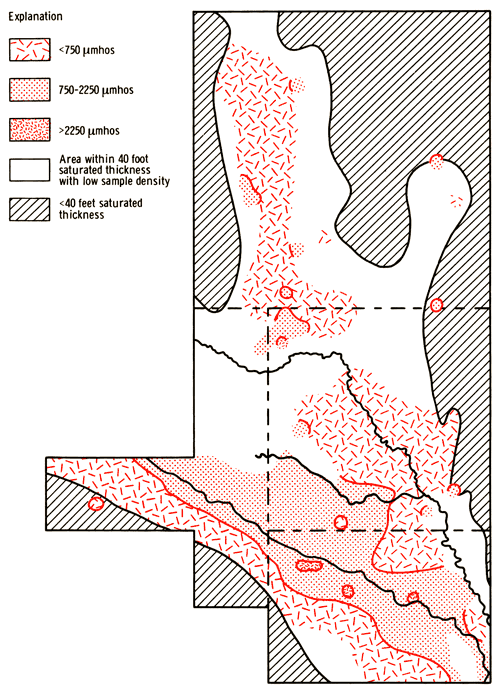
The specific-conductance data for the study area indicate that better quality water is generally found south of the Arkansas River Valley in Reno and Sedgwick counties and in regions east and north of the Wichita well field. However, a few individual well sites overlying the McPherson Channel in areas north of the Wichita well field do have higher specific-conductance levels, suggesting a localized alteration of water quality. Poorer quality waters are derived from wells in the Arkansas River Valley, especially in Sedgwick County. Moving northward from the Arkansas River toward the Little Arkansas River, a general transition from poorer quality waters to better quality waters is observed.
Discussions of the chemical quality of groundwaters in the Equus beds have been presented by several authors. In 1897 Haworth and Beede described groundwaters in the Equus beds as being of good quality. Lohman in 1940 noted that groundwaters from the McPherson-Halstead region of the Equus beds were generally of good quality, except where contamination by oil-field brines had occurred. Appreciable amounts of iron were also noted in the groundwater south of McPherson. Lohman also described waters from the alluvium of the Arkansas River Valley as being of good quality except for a zone of about two miles in width which encompasses the present river channel. The poorer quality of groundwaters in the Arkansas River Valley system between Hutchinson and Wichita has been attributed to contamination by natural, industrial, and oil-field brines and by inadequately treated sewage (Bayne, 1956).
Considerable exploration and development of oil and gas resources has occurred in the Equus beds area. In the early history of this development, "evaporation" or disposal ponds were the principal means of handling the brines produced. Infiltration of brines from these leaky ponds has led to local pollution of the groundwater. Earlier attempts at pressurized disposal of brine into shallow disposal wells also contributed to the deterioration of water quality in the unconsolidated sediments in the region of the Burrton oil field (Williams and Lohman, 1949; Leonard and Kleinschmidt, 1976). Initiation of water-flood operations for secondary recovery in oil fields of the Equus beds area has provided yet another potential mechanism for brine contamination of the fresh-water aquifer. The situation created in the Burrton area continues to be a major concern in the operation of wells in the Wichita well field region. At present, both the City of Wichita and the Equus Beds Groundwater Management District #2 maintain chloride monitoring programs for observation wells in the vicinity of Burrton and the Wichita well field.
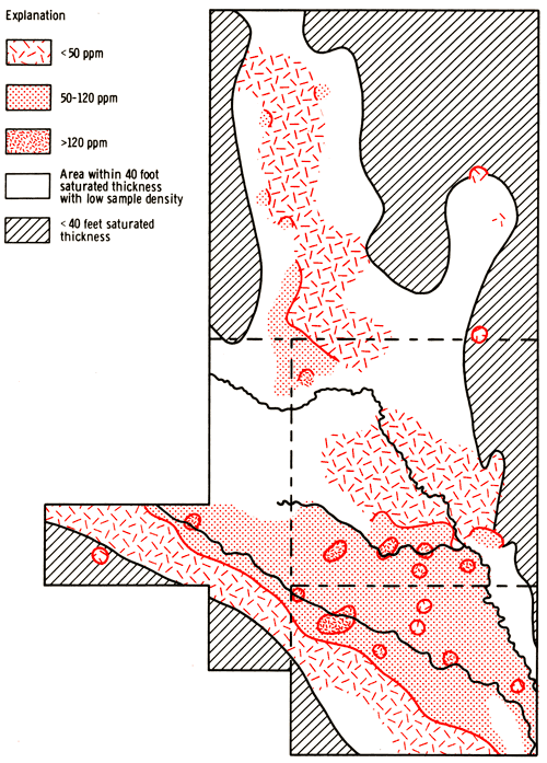
The patterns noted earlier for the specific-conductance data of Figure 8 are in general agreement with groundwater-quality observations made for the Equus beds since 1940. Areal displays of the sodium, chloride, and sulfate data from the 1980 sampling program--Figures 9, 10, and 11, respectively--tend to reflect the same general features found in Figure 8. The area between the Arkansas and Little Arkansas rivers has broad transitional patterns for sodium and sulfate concentration levels, which are similar to the situation found in the specific-conductance data. The chloride data, however, show a much smaller and narrower transition zone, which is restricted primarily to an area near the Arkansas River in Sedgwick County and to the extreme southwestern corner of Harvey County. A comparison of the groundwater-quality data presented by Williams and Lohman (1949) with data from the present study suggests that pumpage of wells in the Wichita well field area has produced little apparent change in the chloride concentration levels of waters in this region. Chloride and sulfate analyses for samples collected in March 1981 from 28 of the municipal wells in the well field also support the notion that chloride levels have remained fairly constant in this area since 1940. However, some increases in sulfate levels appear to exist for municipal wells near Kisiwa Creek, in the area south of Halstead; and elevated sulfate levels are also apparent in Figure 11 for parts of the Kisiwa Creek area. Thus, it appears that the heavy pumpage in this area has not induced upward movement of brine from the bedrock, marked eastward movement of the Burrton brine plume, or movement of poorer quality water from the Arkansas River Valley toward the well field. The presence of the transition zone may be a reflection of the higher incidence of saline and sodic soils, shallower water table, and sandier soils in this portion of the Equus beds.
Figure 9--Concentration levels of sodium.
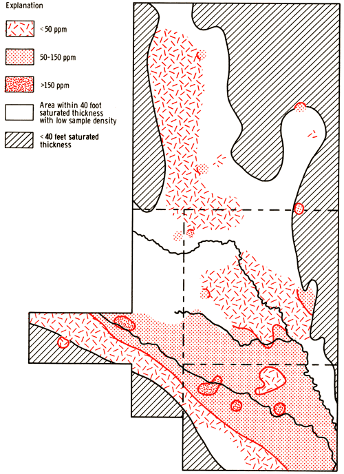
Figure 10--Concentration levels of chloride.
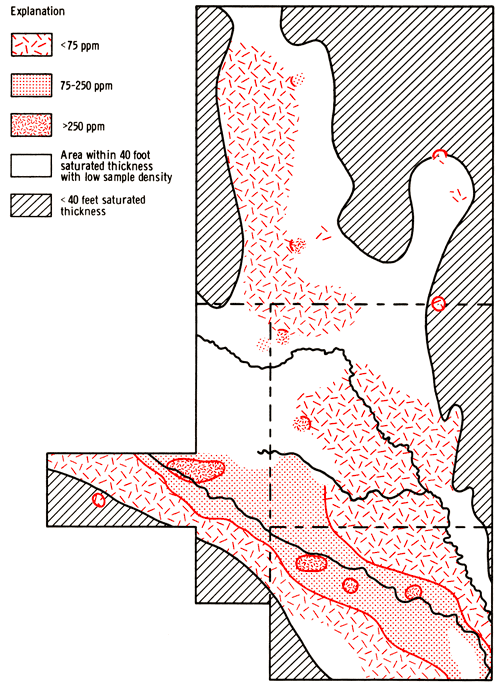
Figure 11--Concentration LeveLs of sulfate.
Between Burrton and McPherson, localized deterioration of groundwater quality through intrusion of brine solutions is suggested by concurrent increases in sodium and chloride concentration and specific-conductance values above regional background levels. The affected wells appear to be underlain by the eastern margin of the Wellington aquifer and are in the proximity of oil fields, both sources of brine.
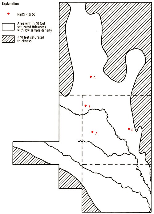
Chloride values by themselves do not serve to distinguish between these two potential sources of brine pollution in the Equus beds region. However, sodium to chloride (Na/Cl) ratios do show some differentiation between the two sources of brine. Na/Cl ratios for brines produced by the dissolution of rock salt (NaCl) should be about 0.65. An average value for the Na/Cl ratio in oil-field brines from the Equus beds area appears to be about 0.53 (Rall and Wright, 1953). Application of these ratios to the determination of the type of brine pollution involved at a given well site is not always straightforward. Cation-exchange reactions within the aquifer system may modify the initial ratio values found in the original brine solutions. Generally, a lowering of values of the Na/Cl ratio should be expected when these brines interact with carbonate-containing sediments of a nonmarine origin.
Figure 12 indicates well locations having Na/Cl ratios below 0.50. All four sites are near oil fields. The chloride level at each of the three sites (A, B, C) between Burrton and McPherson exceeds 400 ppm and the value of the Na/Cl ratio at each site is below 0.35. The potentiometric surface of water in the Wellington aquifer is thought to be below the potentiometric surf ace of water in the overlying freshwater aquifer in this area (Gogel, 1981). Thus, little contamination from brines in the Wellington normally would be expected at these sites unless the wells have been screened at the very bottom of the fresh-water aquifer. Site D, which is northeast of Halstead, is well east of the area underlain by the Wellington aquifer. This site has exhibited an increase in its chloride level from 12 to 53 ppm and a decrease in the Na/Cl ratio from 1.83 to 0.47 between 1973 and 1980. While the present chloride level at this site is not abnormally high in comparison to other irrigation wells sampled in the surrounding area, these changes may indicate the possible onset of brine intrusion. Na/Cl ratios in the range of 0.50-0.65 are associated with a number of wells in the Arkansas River Valley and a few well sites scattered through the study area north of the river.
Figure 12--Locations of wells with Na/Cl ratios below 0.50.
A definitive determination of pollution sources contributing to the deterioration of local groundwater quality in the Equus beds will probably require a more refined geochemical approach to the investigation of these waters. A detailed study of the variations in concentration of selected trace constituents--such as iodide, bromide, boron, and lithium--relative to that of a conservative major component of the waters such as chloride may prove useful in these evaluations. It should be recognized that verification of oil-brine pollution of local groundwater at a well site is one problem; the determination of the point in time for the brine intrusion of the fresh-water aquifer system is a separate and possibly complex issue.
Elevated iron contents of groundwaters in the Equus beds have been noted in areas contaminated by oil-field brine, in the sand-dune area of Reno and Harvey counties, and in the alluvial valley of the Arkansas River (Williams and Lohman, 1949). Lane and Miller (1965) observed that iron contents of groundwaters in Sedgwick County seemed to be influenced by depth in the aquifer, nature of material making up the aquifer, well construction, frequency of pumping, presence of iron bacteria, and a number of other factors. Manganese is a trace element that behaves in somewhat the same manner as iron in the aquifer system. Elevated concentrations of either iron or manganese may impart undesirable characteristics to the water, such as staining, disagreeable taste, and fouling of well screens and sprinkler nozzles. Areal displays of iron and manganese concentration data for the study area are shown in Figures 13 and 14 respectively.
Figure 13--Concentration levels of iron.
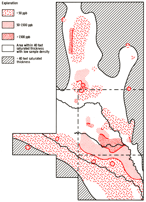
Figure 14--Concentration levels of manganese.
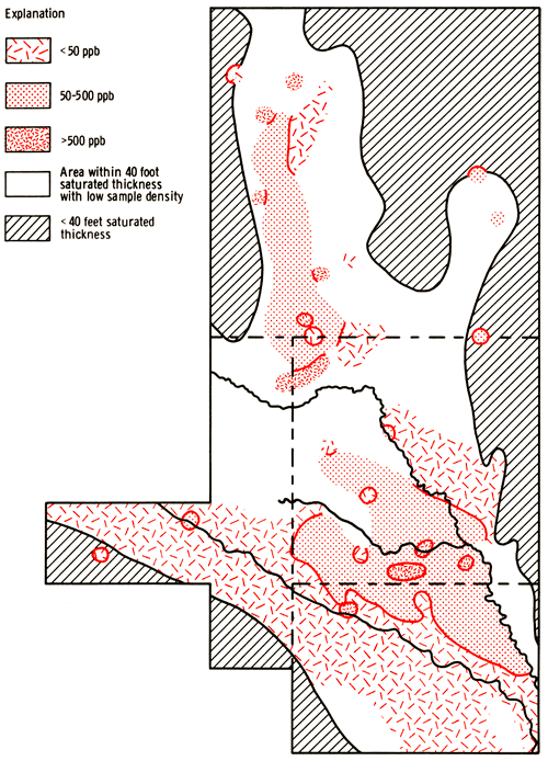
The iron and manganese levels in irrigation waters collected in 1980 for this study are generally higher in that portion of the study area north of Sedgwick County, especially up through the region overlying the McPherson Channel in Harvey and McPherson counties. Iron and manganese concentration levels in this portion of the study area tend to be greater than those normally encountered in irrigation waters from the undifferentiated Quaternary-Tertiary age deposits of the Great Bend Prairie area or western areas of the State that derive irrigation water from the Ogallala Formation of Pliocene age.
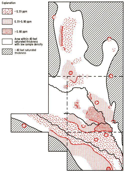
The variations in phosphate concentration levels (Fig. 15) tend to parallel those noted for iron within the study area and between the present and former study areas. Since filtered samples were not collected in the field during this study, it is difficult at this point to break down the total concentrations of iron, manganese, and phosphate at individual well sites into a dissolved component and a suspended component. A more detailed geochemical study of oxidation-reduction conditions within the aquifer, partitioning of trace constituents between dissolved and suspended components, and speciation of the dissolved fraction of the trace components at a few select well sites would be useful in understanding the factors controlling the areal distribution patterns of iron, manganese, and phosphate found in the present study.
Figure 15--Concentration levels of phosphate.
Nitrate concentrations in excess of 30 ppm are mainly associated with wells in the southern portion of the study area where sandier soils and relatively shallow water-table conditions exist. Nitrate levels in wells overlying the McPherson Channel in Harvey and McPherson counties generally are less than 15 ppm, and the median level for the entire study area is only 5.1 ppm. A comparison of data from the 1979 and 1980 sample collections shows a constancy of the nitrate concentration levels over a one-year period of time and under different seasonal cumulative pumping conditions, July 1979 being wet and July 1980 being dry.
Figures 16 and 17 present areal groundwater classifications by cation and anion types, respectively. Water-type classifications used in this report are based upon the percent contributions made by various chemical species to the total number of milliequivalents per liter of cations or anions in each sample. Conversion of the chemical-quality data of Appendix A from parts per million to milliequivalents per liter can be achieved by use of the factors listed in Table 4. These milliequivalent-per-liter values reflect combining capacities of the various chemical species in the water sample.
Figure 16--Groundwater classification by cation type.
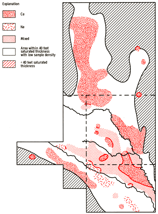
Figure 17--Groundwater classification by anion type.
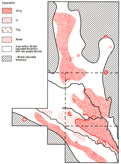
Table 4--Factors for conversion from parts per million to milliequivalents per liter.
| Species | Multiply By |
|---|---|
| Calcium (Ca) | 0.04990 |
| Magnesium (Mg) | 0.08226 |
| Sodium (Na) | 0.04350 |
| Potassium (K) | 0.02557 |
| Strontium (Sr) | 0.02283 |
| Bicarbonate (HCO3) | 0.01639 |
| Sulfate (SO4) | 0.02082 |
| Chloride (Cl) | 0.02821 |
| Fluoride (F) | 0.05264 |
| Nitrate (NO3) | 0.01613 |
These figures suggest that Ca-HCO3 type waters provide the dominant underlying fabric for groundwater classification in the study area. Water chemistries are modified along the Arkansas River to produce Na-Cl, Na-mixed, mixed-mixed, mixed-Cl, and Na-HCO3 type classifications. The Na-HCO3 classification suggests that Ca-HCO3 type waters may be interacting with sodium--rich clay minerals to liberate sodium and fix calcium in parts of the river valley system. The area between the Arkansas and Little Arkansas rivers represents a transition from the sodium- and chloride-enriched waters of the Arkansas River Valley to the Ca-HCO3 type waters which dominate the area north and east of the Little Arkansas River. The transition in this area is much sharper and narrower for anion classifications than for cation classifications. Sites A, B, and C of Figure 12 are chloride-type waters (A and C: Ca-Cl type, B: mixed-Cl type), but waters at site D still reflect a Ca-HCO3 classification. The features noted in Figures 16 and 17 merely serve to augment earlier observations based upon areal distributions of the specific-conductance, sodium, chloride, sulfate, and Na/Cl ratio data.
Sodium adsorption ratio (SAR) values can be calculated from the chemical quality data using the equation
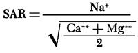
The quantities in parentheses are milliequivalent per liter values of the specified ions. The areal distribution of SAR values for the study area is shown in Figure 18. SAR values in excess of 3.0 are associated with wells in the alluvium of the Arkansas River Valley system. Northward, SAR values diminish 'to values less than 1.5 near the Little Arkansas River. North and east of the Little Arkansas River SAR values tend to remain below 1.5 except at locations where brine intrusion seems to have occurred.
Figure 18--Sodium adsorption ratio (SAR) LeveLs for the study area.
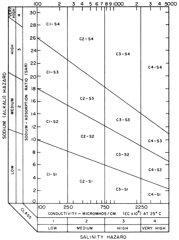
Specific-conductance data from Figure 8 and SAR data from Figure 16 can be used in conjunction with the diagram in Figure 19 to evaluate the general alkali and salinity hazards associated with the use of the groundwaters for irrigation purposes (U.S. Salinity Laboratory Staff, 1954). Also, factors such as the characteristics of the soil and depth to the water table should be considered in the overall compatibility assessment. Compatibility of water quality with an irrigation usage probably is an immediate concern in the study area for portions of the Arkansas River Valley where higher dissolved salt and sodium levels produce classifications that range up through that of medium alkali-very high salinity hazard. In these areas the sandier soils help to compensate for the poorer water quality, but the shallow water table may impede leaching of the soluble salts from the upper portions of the soil columns.
Figure 19--Diagram showing relationship between specific conductance and SAR in the evaluation of salinity of alkali hazards for irrigation.
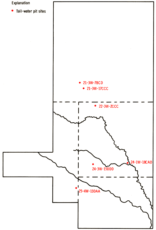
Residual waters collected into tail-water pits associated with flood irrigation operations represent a potentially reusable resource. The water-quality data for samples collected from six tailwater pits and their associated irrigation wells are compared in Table 5. The locations of the tailwater pits are shown in Figure 20. Increases in pH and carbonate levels and decreases in bicarbonate and calcium levels for tail waters compared to corresponding well waters probably reflect the effects of CO2 loss in the higher temperature environments of the surface-water samples. Concentration levels of magnesium, sodium, sulfate, and chloride in the tail waters generally show no increase to only a slight increase above the levels found in the corresponding well waters. Increased SAR values for tail-water samples reflect both the loss of calcium as CaCO3 and any uptake of sodium from the soils. Potassium levels are generally higher in the tail-water samples than in the well-water samples, a fact also noted in northwestern Kansas (Hathaway and others, 1979). Variations in nitrate and phosphate concentrations do not seem to suggest any dominant trends. Re-use of tail waters probably should be monitored closely in areas where higher specific-conductance and SAR values exist for groundwaters and where sodic soils are common.
Table 5--Chemical-Quality Data for Tail-Water Pits and Associated Irrigation Wells
| Location | Sp. Cond. µmho |
Temp. ° C |
pH | SAR | SiO2 ppm |
Ca ppm |
Mg ppm |
Na ppm |
K ppm |
Sr ppm |
HCO3 ppm |
CO3 ppm |
SO4 ppm |
Cl ppm |
F ppm |
NO3 ppm |
PO4 ppm |
|---|---|---|---|---|---|---|---|---|---|---|---|---|---|---|---|---|---|
| 21-3W-7BCA (well) |
652 | 15.3 | 7.4 | 0.70 | 29 | 91 | 16 | 28 | 3.2 | 0.6 | 336 | 0 | 54 | 15 | 0.3 | 0.2 | 0.68 |
| 21-3W-7BCD (pit) |
625 | 21.0 | 8.2 | 0.72 | 26 | 88 | 16 | 28 | 4.3 | 0.6 | 327 | 0 | 56 | 15 | 0.4 | 1.8 | 0.82 |
| 21-3W-20BA (well) |
569 | 15.0 | 7.5 | 0.72 | 27 | 81 | 10 | 26 | 2.2 | 0.5 | 325 | 0 | 17 | 19 | 0.3 | 0.1 | 0.51 |
| 21-3W-17CCC (pit) |
521 | 24.0 | 7.5 | 0.95 | 24 | 63 | 14 | 32 | 5.5 | 0.4 | 285 | 0 | 20 | 20 | 0.4 | 0.5 | 0.59 |
| 22-3W-2C (well) |
735 | 14.5 | 7.2 | 0.94 | 32 | 109 | 9.2 | 38 | 1.8 | 0.4 | 335 | 0 | 45 | 43 | 0.2 | 19 | 0.27 |
| 22-3W-2CCC (pit) |
530 | 29.0 | 8.4 | 1.48 | 31 | 46 | 11 | 43 | 8.0 | 0.3 | 160 | 3.8 | 50 | 49 | 0.2 | 4.5 | 0.11 |
| 24-1W-18CCA (well) |
611 | 15.5 | 7.4 | 1.76 | 23 | 64 | 11 | 58 | 2.7 | 0.4 | 313 | 0 | 43 | 21 | 0.4 | 0.2 | 0.81 |
| 24-1W-18CAD (pit) |
623 | 20.0 | 8.2 | 1.86 | 22 | 63 | 11 | 61 | 3.4 | 0.4 | 308 | 0 | 41 | 21 | 0.5 | 1.6 | 0.80 |
| 24-3W-15DDC (well) |
1195 | 14.0 | 7.2 | 2.20 | 18 | 118 | 23 | 100 | 5.3 | 1.0 | 358 | 0 | 154 | 114 | 0.5 | 2.0 | 0.46 |
| 24-3W-15DDD (pit) |
1210 | 22.0 | 8.0 | 2.22 | 17 | 118 | 25 | 102 | 5.2 | 1.0 | 352 | 0 | 162 | 118 | 0.5 | 3.2 | 0.24 |
| 25-4W-13DAA (well) |
571 | 15.0 | 7.2 | 1.04 | 27 | 68 | 14 | 36 | 2.0 | 0.4 | 281 | 0 | 29 | 15 | 0.3 | 22 | 0.53 |
| 25-4W-13DAA (pit) |
565 | 21.0 | 8.0 | 1.14 | 23 | 64 | 15 | 39 | 4.5 | 0.4 | 283 | 0 | 33 | 16 | 0.4 | 20 | 0.89 |
Figure 20--Locations of tail-water pits sampled in study.
The results of the present study and previous investigations all indicate the chemical-quality state of groundwaters of the Equus beds area is one complicated by alterations induced by both natural and human-related sources. A scarcity of irrigation wells in parts of the present study area has precluded a complete characterization of groundwaters in regions having over 40 feet of saturated thickness. Future stresses upon the groundwater resources of the Equus beds from the growing demands of municipal, agricultural, industrial, and domestic sectors make it vitally important that the present chemical-quality status as well as availability of water in the aquifer system be known for proper management of the resource. An effort should be made to fill in the data base from this study with samples, collected and analyzed under controlled conditions, from new wells in the poorly covered regions of the Equus beds. Establishment of an annual well-monitoring program throughout the Equus beds may be warranted in order to evaluate movements of brines in the total unconsolidated aquifer system. Analysis of samples from this monitoring system probably should include determinations of major cation and anion species so that it is possible to evaluate the general validity of the analyses and the nature of changes taking place.
The authors are indebted to Mr. Gene Buringer, Superintendent of Schools, Unified School District 440, for providing field laboratory facilities. The assistance of J. Gillespie, USGS, in obtaining samples from wells of the Wichita well field and the efforts of Mr. John Yost in obtaining samples in 1979 and selection of sampling sites for the 1980 program are greatly appreciated. The services of Kansas Geological Survey staff--T. McClain, A., Macfarlane, P. Watson, B., Stanley, T. Foster, M. Savage, C. Basil, and D. Whittemore--in the collection of samples and operation of the field laboratory are also acknowledged. The cooperation of Mr. Tom Bell, Manager of Equus Beds Groundwater Management District #2, also greatly facilitated the undertaking of this project.
Adams, G. I., 1903, Physiographic divisions of Kansas: Transactions of the Kansas Academy of Science, v. 18, p. 109-123.
Bayne, C. K., 1956, Geology and ground-water resources of Reno County, Kansas: Kansas Geological Survey, Bulletin 120, 130 p. [available online]
Bayne, C. K., and Ward, J. R., 1967, Saturated thickness and specific yield of Cenozoic deposits in Kansas: Kansas Geological Survey, Map M-5.
Fent, O. S., 1950, Pleistocene drainage history of central Kansas: Transactions of the Kansas Academy of Science, v. 53, no. 1, p. 81-90.
Frye, J. C., and Leonard, A. B., 1952, Pleistocene geology of Kansas: Kansas Geological Survey, Bulletin 99, 230 p. [available online]
Frye, J. C., and Schoewe, W. H., 1953, The basis for physiographic subdivision of Kansas: Transactions of the Kansas Academy of Science, v. 56, no. 2, p. 246-252.Gogel, Tony, 1981, Discharge of saltwater from Permian rocks to major stream-aquifer systems in central and south-central Kansas: Kansas Geological Survey, Chemical Quality Series 9, 60 p. [available online]
Hathaway, L., R., Carr, B. L., Flanagan, M. A., Galle, O. K., Waugh, T. C., and Dickey, H. P., 1978a, Chemical quality of irrigation waters in southwestern Kansas: Kansas Geological Survey, Chemical Quality Series 6, 35 p. [available online]
Hathaway, L. R., Carr, B. L., Galle, O. K., Magnuson, M. L., Waugh, T. C., and Dickey, H. P., 1977, Chemical quality of irrigation waters in Hamilton, Kearny, Finney, and northern Gray counties: Kansas Geological Survey, Chemical Quality Series 4, 33 p.
Hathaway, L. R., Galle, O. K., Waugh, T. C., and Dickey, H. P., 1978b, Chemical quality of irrigation waters in Ford County and the Great Bend Prairie of Kansas: Kansas Geological Survey, Chemical Quality Series 7, 41 p. [available online]
Hathaway, L. R., Magnuson, M. L., Carr, B. L., Galle, O. K., and Waugh, T. C., 1975, Chemical quality of irrigation waters in west-central Kansas: Kansas Geological Survey, Chemical Quality Series 2, 45 p.
Hathaway, L. R., Waugh, T. C., Galle, O. K., and Dickey, H. P., 1979, Chemical quality of irrigation waters in northwestern Kansas: Kansas Geological Survey, Chemical Quality Series 8, 45 p. [available online]
Haworth, E., and Beede, J. W., 1897, The McPherson Equus Beds: University Geological Survey of Kansas Volume II, p. 285-296.
Hoffman, B. R., and Dowd, L. W., 1974, Soil survey of Harvey County, Kansas: U. S. Department of Agriculture, 55 p.
Lane, C. W., and Miller, D. E., 1965, Geohydrology of Sedgwick County, Kansas, Kansas Geological Survey, Bulletin 176, 100 p. [available online]
Leonard, R. B., and Kleinschmidt, M. K., 1976, Saline water in the Little Arkansas River Basin area, south central Kansas: Kansas Geological Survey, Chemical Quality Series 3, 24 p.
Lohman, S. W., 1940, Ground water in the McPherson District, Kansas: Kansas Geological Survey, Bulletin 27, p. 63-66.
Moore, R. C., 1940, Ground-water resources of Kansas: Kansas Geological Survey, Bulletin 27, 112 p.
Oros, M. O., 1975, Oil and gas fields in Kansas: Kansas Geological Survey, Map M-3A.
Penner, H. L., and Wehmueller, W. A., 1979, Soil survey of Sedgwick County, Kansas: U. S. Department of Agriculture, 126 P.
Rall, C. G. , and Wright, J. , 1953, Analysis of formation brines in Kansas: U. S. Bureau of Mines, Report of Investigations 4974, p. 8-40.
Rockers, J. J., Ratcliff, I., Dowd, L. W., and Bouse, E. F., 1966, Soil survey of Reno County, Kansas: U. S. Department of Agriculture, Series 1960, no. 29, 72 p.
Rott, D. E., Soil survey of McPherson County, Kansas: U. S. Department of Agriculture, in press.
Schoewe, W. H., 1949, The geography of Kansas, part II, physical geography: Transactions of the Kansas Academy of Science, v. 52, no. 3, p. 261-333.
Stramel, G. J., 1956, Progress report on the ground-water hydrology of the Equus beds area, Kansas: Kansas Geological Survey, Bulletin 119, part 1, p. 1-59.
Stramel, G. J., 1967, Progress report on the ground-water hydrology of the Equus-Beds area, Kansas--1966: Kansas Geological Survey, Bulletin 187, part 2, 27 p. [Available online]
Williams, C. C., and Lohman, S. W., 1949, Geology and ground-water resources of a part of south-central Kansas with special reference to the Wichita municipal water supply: Kansas Geological Survey, Bulletin 79, 455 [available online]
U.S. Salinity Laboratory Staff, 1954, Diagnosis and improvement of saline and alkali soils: U. S. Department of Agriculture Handbook 60, 160 p.
Kansas Geological Survey
Placed on web Oct. 6, 2012; originally published in 1981.
Comments to webadmin@kgs.ku.edu
The URL for this page is http://www.kgs.ku.edu/Publications/Bulletins/CQS10/index.html