![]()
Prev Page--Contents || Next Page--Description
Please Note
1. The term "Dakota" as used in this report relates only to the strata of Kansas known by that name. In the writer's opinion the strata known as the Dakota formation or group are probably of considerably different ages in different portions of the West.
2. The Comanchean formations have previously been referred to the Lower Cretaceous, which in general has been correlated with the Lower Cretaceous of Europe. Applying the criteria as stated by the writer in a previous article (78) relating to these strata, appears to necessitate their reference to the Upper Cretaceous. The validity of the term Comanchean as the name of a geologic period remains to be established. That question is not considered in this report.
3. References indicated by bold face numbers in the report are listed in the Bibliography following the text of this report. (See "Bibliography" in Table of Contents.)
Introduction
The Comanchean and "Dakota" formations of Kansas occur in two widely separated areas, one in the central and northern portions of the state and the other near the southern margin. The strata of the south are in considerable part calcareous, but they begin with a basal formation composed of sandstone and constituting from a fourth to a half of the entire sequence which without gradation gives place to shell limestones and dark shales. These strata are exposed in narrow strips over a large section of the country, but in few places do they form the uplands, generally being confined to the valley slopes. They have been variously correlated and named. The strata of the central and northern portions of the state are largely red sandstones, which have been generally, known as the "Dakota" sandstones and the Mentor beds. These strata occur as isolated outliers on their eastern extensions and cover extensive areas on the western margins.
There are no known surface connections between the two areas, but it is possible that connection may exist beneath the overlapping Benton and Tertiary strata. Whether present or not, it is certain that such connection once existed and that these strata also were at one time connected with the extensive areas of strata of the same general age which are present in southern Oklahoma and across central Texas. Save, however, for an occasional outlier, the strata connecting with these southern areas have been removed.
The strata under consideration in the southern part of Kansas have been considered of Comanchean age and have been so mapped by the Kansas Geological Survey (50). The most recent maps of the state by the Survey (69) have placed the Mentor beds with the "Dakota" and have assigned both to the Upper Cretaceous.
The Comanchean strata of Kansas are of interest from several points of view. They throw considerable light on the climatic conditions prevailing in this region during the times of their deposition, record forward and backward migrations of the strand line, and show many variations in both the horizontal and vertical distribution of the sediments. Coupled with the variations in sediments are variations in faunas, showing the close relationship that the animals of the time bore to their environments.
Data relating to these formations are scattered through a great number of papers, many of which are difficult of access, and descriptions of the fossils have not previously been assembled. The material presented in this report has been derived from a number of years work, including parts of three field seasons and studies of the fossil collections carried on as other duties permitted. Each of the previously described localities of the Mentor beds has been examined and several new ones have been found. In the southern part of the state all of the well-known sections have been studied and some of them have been visited several times.
In this work assistance has been received from many persons who live near the exposures. The study was begun under Dr. Erasmus Haworth, former state geologist of Kansas, and has been continued with the cordial cooperation of the present state geologist, Dr. Raymond C. Moore.
Résumé of the Literature
Southern Kansas
The strata of southern Kansas here considered appear to have been first noted by Mudge, and were by him included in the Upper Cretaceous and assigned to the Benton and "Dakota" formations (17, pp. 47-55). Cragin assigned the calcareous and shaly portions to the Benton, but noted that the underlying sandstones are quite different from any in Kansas with which he was familiar (22, p. 85). In 1886 Cragin referred the lower sandy beds to the "Dakota" (23, p. 166). These correlations were continued by St. John (24, p. 143) and by Hay (25, p. 22). In February, 1889, Cragin (26, p. 33) stated the discovery of error in his earlier correlation, and in the same paper gave the first detailed geologic section of these strata, the lithologic description of each zone being accompanied, by a list of fossils characteristic of that zone. The resemblance of the fossils to those of the Comanchean of Texas was also noted. Basing his conclusions on the statements made in Cragin's paper, Hill (27, p. 115) made the definite correlation of the basal sandstones with the Trinity of the Texas section and the overlying argillaceous and calcareous strata with the Fredericksburg of the same sequence. In a paper appearing in the latter part of 1889, Cragin (28, p. 65) reservedly accepted Hill's correlation for the sandstone and in the same paper suggested the formation term of Cheyenne therefor, the type locality for the formation being Cheyenne Rock on the south side of Medicine Lodge river near the village of Belvidere. The sandstone and overlying strata were more fully described by Cragin (29) in the following year and considerable detail relating to their distribution and characteristics was given.
In 1890 Hay (30, p. 49) gave brief descriptions of the geology of Kansas, in which be continued the correlation of the Cheyenne sandstone, with the "Dakota," and with some doubt referred the overlying strata to the Fort Benton. In 1891 Cragin (32) made a very definite and positive correlation of the basal sandstones with the Trinity of Texas and a portion of the overlying strata (No. 5 of his sections) with the Fredericksburg. Williston's (33) small geologic map of Kansas shows the presence of Comanchean strata in southern Kansas, the area of the exposures extending from the southeastern part of Kingman county westward in an irregular line into the northeastern part of Meade County. Hay's map (35) shows the same area as Upper Cretaceous, but correlates the strata with the Lower Cretaceous, tentatively suggesting that the Texas names, Trinity sandstone and Comanche Peak limestone, should be retained for them.
In the following year (1894), Cragin (38) described the first invertebrate fossils from the strata of southern Kansas and descriptions of others together with those of vertebrate fossils from the same strata were given by him in 1895 (42, 43). In the latter paper he suggested the formation name Kiowa for the calcareous and shaly beds overlying the Cheyenne sandstones. In the same year Hill (45) published the discovery of the presence of fossils of dicotyledonous plants in the Cheyenne sandstones and stated that the species which are present are those which have previously been considered characteristic of the "Dakota." Cragin (28, p. 65) had previously described a cycad from the Cheyenne sandstones. Also in 1895, in connection with sections from other localities, Hill (46) gave two from southern Kansas--one from near Sun City and a second from near Belvidere. In this paper he proposed that those portions of these strata above the Cheyenne sandstone be known as the Belvidere shale. The paper also gave Knowlton's list of the plants which had been found in the Cheyenne sandstone, with his conclusions that the species identified "belong to the Dakota group as it has usually been accepted, and have never been identified outside of it." The invertebrate fossils from the overlying shales were listed with identifications by Stanton; and on the basis of the evidence given by all the fossils, Hill correlated the sequence as "the modified attenuated northern extensions of the Washita division and probably a portion of the Fredericksburg division of the Comanche series of Texas." (46, p. 234).
In the latter part of 1895 Cragin (47) published his last paper on the southern Kansas section. This paper to a considerable degree is controversial, but various names were proposed for members of the Comanchean sequence, the basal lithologic unit of the "Kiowa shales" in particular being separated as the Champion shell bed and given rank equal to the Cheyenne sandstone. Thirty-six species of invertebrates were listed from the Champion shell bed, and it was stated that fifty-one species of invertebrates and nine species of vertebrates are present in the "Kiowa shale." In respect to correlation Cragin concluded that the "Kiowa shale represents a group of sediments intermediate between the Fredericksburg and the Washita."
Haworth's (48, pl. xxxi) "Reconnaissance Geological Map of Kansas" shows a band of Comanchean strata extending from the northwest corner of Barber County to the southeastern corner of Meade County.
The most extensive paper discussing the southern Kansas section is that of Prosser (50). This paper reviews all previous work relating to these strata and gives abundant facts relating to their distribution and local sequence.
Additional papers have been published by Vaughn (53), Gould (55, 59), Stanton (64), Twenhofel (78), and Berry (79, 80, 81).
Central and Northern Kansas
The central Kansas strata appear to have been observed first by Dr. John L. LeConte (5). While a member of a party making a survey for the extension of the Union Pacific railroad west of Salina, he collected fossils south of Spring creek crossing, a locality near the present little village of Bavaria. He referred the strata to the "Dakota" and stated that Prof. B. F. Mudge had collected fossils near the same place. In 1872 Mudge (6, p. 38) published details relating to the locality where he discovered the fossils and in the same year the fossils were described without figures by Meek (8). Four years later Meek republished his descriptions with figures (13, pl. 2). In 1877 and 1878 Mudge (16, 17) gave further data relating to the localities from which he obtained his fossils.
Cragin was the first student who appears to have clearly recognized the relations of the fossiliferous sandstones of central Kansas to those of the Kiowa of southern Kansas. He patiently sought for exposures, and proposed for these strata the name "Mentor beds," the type locally being near the little railroad station of that name (44). Prosser (50) compiled the results of the work of earlier students and greatly added thereto through his own studies. These sandstones have also been studied by Gould (59), who gave a section in which the strata are shown in place, and announced the discovery of fossils of dicotyledons in the supposed unfossiliferous sandstones which are present beneath the sandstones in which the marine fossils occur. The present writer has published the general facts relating to these strata so far as they were known at the times of publication (77, 78).
The "Dakota" sandstone of southern and central Kansas has generally been considered the basal division of the Upper Cretaceous. In its first definition it was given as the base of the plains Cretaceous, and this assignment was restated by the sponsors, Meek and Hayden (2), in many subsequent papers. In his great work on the Cretaceous and Tertiary fossils of the Plains and Rocky Mountain portions of the United States, Meek (13, pls. xxv-xxviii) reconsidered the assignment and reached the same conclusion as in previous years. Other students have dissented from the assignment, Marcou at one time referring the division to the Triassic, at another time to the Jurassic, and when Heer identified fossil leaves from the "Dakota" as Miocene, Marcou adopted a like view. After he had studied the strata in the field, however, he reached the conclusion that the assignment of Meek and Hayden is correct. The age, origin and position of the "Dakota" was considered by Lesquereux (9, p. 26), who decided that the age is Upper Cretaceous and its origin marine, this view of origin being based on the occurrence of marine fossils which had been found in the rocks on the Big Sioux river and in Kansas (Mentor beds). These conclusions as to stratigraphic position have been generally accepted and quite generally embodied in all American textbooks of geology except that of Scott.
After the initial doubts as to the position of the "Dakota" had passed, it appears to have been generally accepted that it is the base of the Upper Cretaceous as that unit has been defined in North America. An occasional note of uncertainty, however, has been sounded by a few students. Among these Prof. L. F. Ward appears to have been the pioneer, as shown in his statement that "It would seem probable that a considerable portion of the deposits underlying the marine Cretaceous of the Rocky Mountain region, which have heretofore been referred to the "Dakota" group on purely stratigraphical evidence, may really be much older (39, p. 265).
In his paper on "Types of Sedimentary Overlap," Grabau (66, pp. 620-627) strongly insisted on the Comanchean age of at least a part of the "Dakota," and also maintained that the "formation" is of different ages in different parts of its distribution.
In Scott's "Introduction to Geology" (75) the "Dakota" is definitely placed in the Lower Cretaceous. A summary of the conclusions of American students on this subject was made by Todd (73, pp. 65-69), and as a result of his examination of the literature he reached the conclusion that the "Dakota" is Lower Cretaceous. In a preliminary paper the present writer (78) presented the evidence relating to the position of the Kansas "Dakota" and reached the conclusion that portions of it are equivalent to the Washita of the Comanche series as that group has been defined in Texas.
Distribution of the Comanchean and "Dakota" Formations
Southern Kansas
The strata in southern Kansas which are here considered are those known as the Cheyenne sandstone, the Kiowa shale and Medicine beds. They make their appearance from beneath the Tertiary cover northeast of Medicine Lodge in the northeastern corner of Barber County, and as an irregular, narrow band extend in a generally westerly direction around the headwaters of Medicine Lodge river, Bluff creek canyon and other streams to the southeast corner of Meade County. In addition to this band there is an outlier in southern Comanche County and northern Oklahoma known as Avilla Hill. It is possible that small patches may occur both east and west of the limits given. The actual area of land immediately underlain by these strata is small.
The most easternmost point where fossils belonging to these horizons have been collected is 6 miles northeast of Medicine Lodge, where they were obtained by Gould (49, p. 119). That the strata once extended farther east is certain, for Kiowa shells have been collected in a Tertiary conglomerate near the village of Sharon--about 7 miles east of where the shells have been found in place. North of Lake City, not far to the northwest of Medicine Lodge, are yellowish-gray fine-grained soft sandstones which rest unconformably on the Permian red beds, and are about 20 feet thick. They are overlain by red concretionary sandstone of a considerable but unknown thickness. The deposits appear to be in a valley in the Permian, and are considered to represent the Cheyenne.
The western limit of the exposures is on Big Sand creek at a place known as Little Basin, where Tertiary sandstone overlies 25 feet of thin-laminated black shale belonging to the Kiowa, which rests in turn on yellowish, coarse-grained friable sandstone described by Cragin as the Big Basin sandstone, of probable Permian age. Westward and southward the overlapping Tertiary rests on the Permian.
Central and Northern Kansas
The rocks of central and northern Kansas which are considered the equivalents of the Kiowa-Cheyenne-Medicine strata consist of: (1) red fossiliferous marine sandstones generally known as the Mentor beds; (2) the underlying strata down to the top of the Permian, some of which are of marine origin; and (3) a portion of the "Dakota" sandstone. The Mentor beds with their characteristic fossils are present over the western halves of Saline and McPherson counties and along the eastern edges of Ellsworth and Rice counties. The most eastern locality where they have been found is in western Marion County, on the road between Lehigh and Waldeck. The most northern locality is about 5 miles north and 1 mile east of Salina. The most western exposures appear to be east of a line extending about 2 miles west of Windom, in McPherson County; 6 miles west of Marquette, in the same county; and about 1 mile west of Brookville, in Saline County. Westward from these limits the Mentor strata disappear beneath the "Dakota." The exposures are in the nature of outliers, and it is certain that the strata once extended east of the limits given. Sandstones and shales similar to those below the Mentor beds have been traced as far north as Longford, in the southwestern corner of Clay County. About 3 miles south of Carlton, in eastern Dickinson County, are red sandstones of "Dakota" aspect which are underlain by 6 to 8 feet of white gypsiferous sandstone, below which are about 20 feet of bluish shales and thin gray sandstones. The strata below the red sandstones are like those below the Mentor beds. Similar strata are exposed 5 1/2 miles south and 5 miles west of this locality, and again 5 miles north and 2 1/2 miles west of Durham, in northern Marion County.
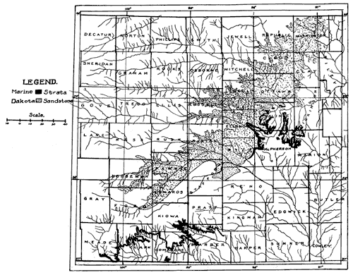
The "Dakota" sandstones are found over an extensive area. They enter the state from Nebraska on the northern edge of Washington County, and, extending in a southwesterly direction to Edwards and Hodgeman counties, they pass beneath the Tertiary cover, entire or extensive areas of fourteen counties having strata of this unit for the surface rock. It is probable that considerable areas along the eastern limits of the "Dakota" exposures lie below the horizon of the Mentor, but it is extremely difficult to make the differentiation where the Mentor horizon cannot be found. The distribution of the strata under consideration is shown on Plate I.
Plate I--Map showing distribution of the Commanchean and "Dakota" strata of Kansas. The distribution of the Dakota is taken from the map of the Kansas Geological Survey, vol IX. Both a larger version and an Acrobat PDF (1.8 MB) of this figure are available.
Prev Page--Contents || Next Page--Description
Kansas Geological Survey, Geology
Placed on web February 2006; originally published 1924.
Comments to webadmin@kgs.ku.edu
The URL for this page is http://www.kgs.ku.edu/Publications/Bulletins/9/02_intro.html