![]()
Prev Page--Introduction, Climate, Topography || Next Page--Ground Water
Geology
General
Ellis and Russell Counties are underlain by rocks of Cretaceous age. In addition, patches of Tertiary deposits overlying the Cretaceous rocks remain on parts of the upland, and materials of Quaternary age have been deposited in the stream valleys.
The following brief discussion of the geology and water-bearing properties of the Cretaceous and younger rocks has been taken chiefly from reports by Rubey and Bass (1925), Frye and Brazil (1943), and McLaughlin (1944).
The oldest Cretaceous rocks that crop out in this area comprise the Dakota formation, which consists of variegated clay, sandy shale, and sandstone. About 160 feet of this formation is exposed along the valleys of Smoky Hill and Saline Rivers in Russell County.
The sandstone beds of the Dakota formation yield small to moderate supplies of water to domestic and stock wells in parts of the area, but in many places the water has a high chloride content and is not suitable for ordinary use.
The Dakota formation is overlain by about 40 feet of dark-gray clay shale and sandy shale classified as Graneros shale, a formation that yields little or no water to wells in the area under consideration.
Overlying the Graneros shale is the Greenhorn limestone, which consists of about 100 feet of chalky shale, chalk, and thin-bedded limestone. The limestone and chalk in this formation yield very small quantities of potable water to a few stock and domestic wells in Russell and Ellis Counties.
The next higher formation in the Cretaceous sequence, the Carlile shale, underlies much of the upland surface in Ellis and Russell Counties. The lower part of this formation consists chiefly of chalky shale and chalk, whereas the upper part is mainly clay shale containing sandy shale and sandstone (Codell sandstone member) at the top. Very little water can be obtained from the Carlile shale, except in a few places where the sandstone member at the top yields small quantities of water for domestic and stock uses.
The uppermost Cretaceous rocks that crop out in Russell and Ellis Counties comprise the Niobrara formation, This formation consists of chalk, chalky limestone, and chalky shale and yields little or no water to wells.
Silt, sand, and gravel of Tertiary age were laid down over most of Ellis and Russell Counties, but much of this material has been removed by erosion, leaving only thin deposits on the higher parts of the upland areas. The down-cutting of the streams has resulted in the draining of so much of the water from these beds that they yield only small quantities of water to a few wells.
Deposits of Quaternary age have been laid down in this area by the major streams. These beds comprise the Pleistocene terrace deposits, which were laid down when the stream flowed at a higher level than at present and are found only along the sides of the valley; and the alluvium that was laid down more recently and is found in the bottom lands.
Silt comprises the upper part of the Quaternary deposits in most places, and unconsolidated sand and gravel comprise the lower part. These deposits in some places are adequately thick and permeable to yield relatively large quantities of water to wells. In most of Russell County, however, the water in the Quaternary deposits has been contaminated by brackish or salt water from the sandstone of the Dakota formation, or from oil-field brines, or from both sources.
Vicinity of Hays
The rocks that crop out in the Hays area include the Carlile shale and overlying Niobrara formation, both Cretaceous in age, terrace deposits of Pleistocene age, and Recent alluvium. Their areal distribution is shown on the map of the Hays area (Fig. 3).
Figure 3--Map of the Hays, Kansas, area showing geology and location of wells and test holes.
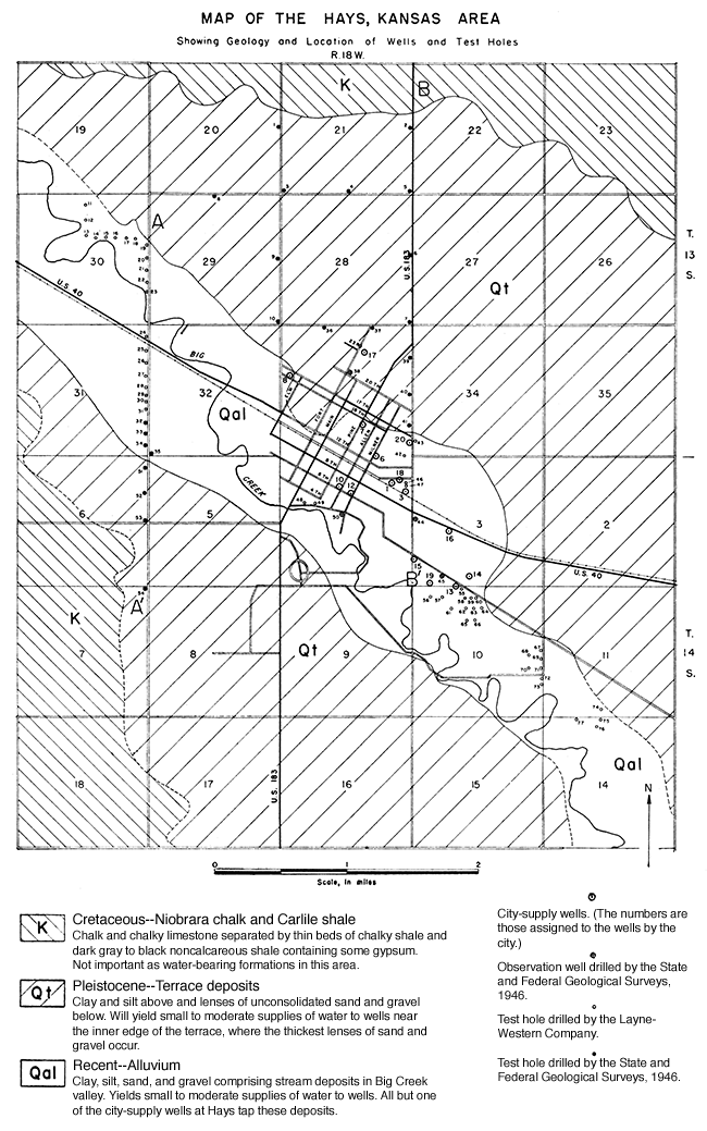
The high areas north and southwest of Hays are underlain by the Niobrara formation. The Carlile shale forms the slopes below the Niobrara hills, and makes up the bedrock beneath the terrace deposits and alluvium throughout this area.
The most important sources of ground water in the Hays area are the terrace deposits that underlie the surface northeast and southwest of Big Creek Valley, and the alluvium in Big Creek Valley.
Exploratory test drilling in Big Creek Valley by the LayneWestern Company preceded the drilling of many of the city wells. The logs of most of these test holes are included in the present report. The logs of 27 test holes drilled in the Hays area by the State and Federal Geological Surveys in April 1946 are-also included. Altitudes of the land surface at all test holes, city wells, and observation wells were determined by plane table and alidade.
The locations of the test holes in the Hays area are shown on Figure 3 and the logs are given at the end of this report.
North of Hays 16 test holes (nos. 1 to 10 and 36 to 41) were drilled, and four (nos. 51 to 54) were drilled southwest of Hays to determine the character and thickness of the terrace deposits. The test drilling indicates that the terrace deposits attain thicknesses of 55 to 81 feet along the edge of the terraces (Fig. 4) and become very thin near the bluffs formed by Cretaceous rocks, as shown in profile B-B' of Figure 4.
Figure 4--Geologic profiles across Big Creek Valley near Hays, Kansas. Locations of the profiles are shown on Figure 3.
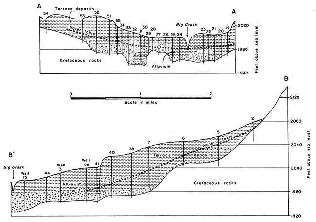
The maximum thickness encountered, 81 feet, was in test hole 9 about 1 1/2 miles northwest of Hays. In the area west of Hays the maximum thickness of terrace deposits penetrated was 63 feet, in test hole 52, as shown in profile A-A' of Figure 4.
The terrace deposits consist predominantly of silt but contain some sand and gravel. The silt is mainly in the upper part and is generally tan to brown; but beds of gray, blue-gray, and dark gray silt were encountered in some test holes. Calcium carbonate nodules and stringers are common in the silt and locally there are lenses or zones containing fine to coarse sand. Beds of sand and gravel, ranging in thickness from a few feet to about 35 feet, underlie the silt in most places.
The beds of sand and gravel are comprised of poorly sorted fine sand to coarse gravel that locally contains silt in varying proportions. Pebbles of limestone are common in the gravels. The thickest beds of sand and gravel are near the edge of the terrace bordering the northeast side of Big Creek Valley. A short distance back from the edge of the terrace the beds of sand and gravel are much thinner; and near the Cretaceous bluffs the terrace deposits contain little or no sand and gravel, but consist almost entirely of silt. The greatest thickness of sand and gravel encountered in the terrace deposits southwest of Hays was 15 feet, in test hole 51.
Many stock wells and domestic wells in the Hays area obtain water from sand and gravel in the terrace deposits. Most of these are wells of small diameter having small yields. City well 17, in the northern part of Hays, also derives its supply from these deposits. It is a drilled, gravel-packed well 68 feet deep and 12 inches in diameter. On May 22, 1943, the measured depth to water level in the well was 48.95 feet below the land surface. The yield of this well when it was constructed in 1941 was 260 gallons a minute, but the yield has declined since that time, and in April 1946 was 180 gallons a minute. Comparable yields may be expected from other properly constructed wells in a narrow belt along the terrace bordering Big Creek Valley north and northwest of Hays.
The alluvium in Big Creek Valley consists of stream-laid deposits that range in texture from clay and silt to sand and coarse gravel. The upper 10 to 50 feet of the alluvium consists of silt and sand that has been deposited over the flood plain in time of flood, or under normal conditions in the channel of the stream. Beneath the finer deposits are lenses of coarse sand and gravel that are lithologically similar to the terrace gravels described above.
The sand and gravel in the alluvium varies greatly in thickness, as shown in Figure 3 and as indicated in the logs given at the end of this report. The test holes encountered from a few inches to 23 feet of sand and gravel in the alluvium in the Hays area.
Locally the alluvium contains no sand and gravel (logs 19 and 70). The alluvium grades into the terrace deposits, so in some places the lower part of the valley fill is probably of Pleistocene age and represents the basal part of a cut-and-fill terrace deposit. The thickness of the alluvium in Big Creek Valley as revealed by test drilling ranges from about 20 to 56 feet. The thickness differs greatly, however, even in short distances, both along and across the valley (Fig. 4).
The alluvial sand and gravel in Big Creek Valley is the source of supply for all the Hays city-supply wells except number 17 and for many stock and domestic wells. The yields of the city-supply wells tapping the alluvium range from 30 to 200 gallons a minute.
Vicinity of Victoria
The uplands in the vicinity of Victoria are underlain by silt, sand, and a small amount of gravel of Tertiary age. According to the records of stock wells and domestic wells in this area, these deposits are relatively thin and consist chiefly of fine sediments, only the lower few feet being saturated. Available data indicate that the Tertiary deposits in this area furnish only meager supplies of water to wells.
The Tertiary deposits are underlain, in descending order, by the Carlile shale, Greenhorn limestone, Graneros shale, and Dakota formation, all Cretaceous in age. Moderate supplies of water are obtainable from deep sandstone beds of the Dakota formation, but the water is highly mineralized and is not suitable for domestic use.
Unconsolidated deposits of Pleistocene and Recent age occur in a narrow belt along Victoria Creek. The total thickness of these deposits ranges from less than 10 feet to about 50 feet. They consist chiefly of silt, sandy silt, and sand, but contain small lenses of poorly sorted sand and gravel in the lower part. The thickness of the saturated part of the terrace deposits and alluvium ranges from less than 5 feet to about 30 feet.
Small supplies of water are obtained by wells tapping the terrace deposits and alluvium in the valley of Victoria Creek. All the Victoria city-supply wells and a few stock and domestic wells in this area derive water from these deposits.
Vicinity of Walker
In 1942 the writer was called upon to assist in locating a water supply for the Walker Army Air Base, situated about 1 1/4 miles north of Walker. During the course of this investigation the Layne-Western Company drilled a total of 16 test holes, six being on or near the site of the air base, seven in Victoria Creek Valley south of Walker, and three in Big Creek Valley south of Walker. The following discussion is based in part on the results of this test drilling.
The surface in the vicinity of Walker is underlain by 20 to 35 feet of Tertiary deposits that consist chiefly of silt and clay but contain some sand and a very little gravel. Although these deposits furnish small supplies of water to stock and domestic wells in this area, they are not sufficiently permeable or thick enough to serve as a source for city-supply wells. The Tertiary deposits are underlain by the Carlile shale.
Test holes drilled in Victoria Creek Valley southwest of Walker, in the S2 NE sec. 21, T. 14 S., R. 16 W., indicate that the thickness of alluvium in this area ranges from about 30 feet to 38 feet. The upper part of the alluvium consists of silt and clay and the lower 10 to 20 feet consists of water-bearing sand and gravel. A test well tapping alluvium in this area yielded 35 gallons a minute with a draw down of 5.6 feet.
In the valley of Big Creek south of Walker three test holes were drilled in the NE NE sec. 34, T. 14 S., R. 16 W. The alluvium in this small area was 18 to 21 feet thick, and a maximum of 14 feet of sand and gravel was encountered. It is believed that a more extensive test-drilling program would reveal greater thicknesses of alluvium in other places in this area.
Vicinity of Gorham
Clay, silt, sand, and gravel of Tertiary age overlie the Carlile shale and comprise the surface deposits in the Gorham area. These deposits are less than 30 feet thick in most places, and only the lower few feet, which generally consists of sand or gravel, is water bearing. Stock and domestic wells in this area obtain small supplies of water from these sediments.
A narrow belt of Recent alluvium consisting chiefly of clay, silt, and sand occupies the valley of a small unnamed ephemeral stream that flows from north to south along the west edge of Gorham. The alluvium in this small valley is very thin and only the lower part is water bearing. A few shallow stock and domestic wells and the Gorham school well obtain water from the alluvium.
Vicinity of Russell
The upland area in the vicinity of Russell is underlain by the Carlile shale. Thin deposits of silt, sand, and gravel of Tertiary age locally mantle these Cretaceous rocks. Saline River north of Russell and Smoky Hill River south of Russell have cut relatively wide and deep valleys, exposing along the sides the Greenhorn limestone, Graneros shale, and Dakota formation. Alluvial deposits of Pleistocene and Recent age have been deposited in those valleys.
Prev Page--Introduction, Climate, Topography || Next Page--Ground Water
Kansas Geological Survey, Geohydrology
Placed on web Sept. 20, 2016; originally published Dec. 15, 1948.
Comments to webadmin@kgs.ku.edu
The URL for this page is http://www.kgs.ku.edu/Publications/Bulletins/76_6/03_geol.html