Kansas Geological Survey, Bulletin 76, part 5, originally published in 1948
Originally published in 1948 as Kansas Geological Survey Bulletin 76, part 5. This is, in general, the original text as published. The information has not been updated. An Acrobat PDF version of this report is available (3 MB).
A detailed radioactivity survey in parts of Cherokee County indicates that the Geiger-Muller counter is of no value either in locating ore bodies or in delineating major structural features in the Tri-State district.
In 1941, the writer participated in a comprehensive geophysical investigation in the Tri-State zinc and lead mining district (Jakosky, Dreyer, and Wilson, 1942). At that time, the original project was to be supplemented by making a radioactivity survey the following year. The intervention of hostilities, however, prevented resumption of the work until the summer of 1947.
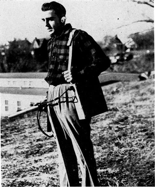
The present investigations were made by using a portable Geiger-Muller counter (Pl. 1). The counter was standardized each day with a radioactive standard.
Plate 1--Geiger-Muller counter in operation.
The writer is much indebted to Prof. Frank Hoecker, Department of Physics, University of Kansas, who supplied valuable data on the theory of radioactivity, and to the following geologists and engineers who did much to facilitate the investigation: George M. Fowler, Victor Rakowsky, S. S. Clarke, and F. J. Cuddeback, Very able field assistance was given by G. L. Campbell, R. A. Hartenberger, and E. L. Suagee.
A representative structure and several characteristic ore bodies were chosen for study to ascertain whether radioactivity prospecting could show either location of the ore or location of structures associated with the ore.
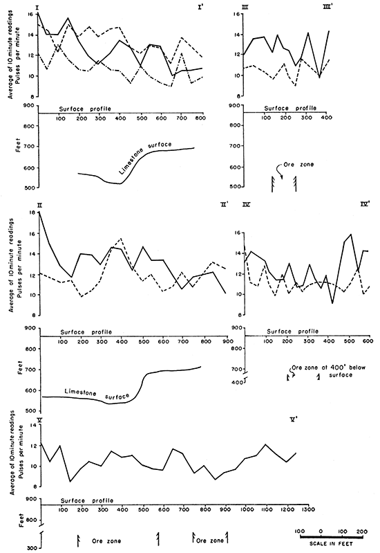
One of the major structures in the Kansas part of the Tri-State mining district is the northeastward-trending Mullen trough, Two traverses were made across this trough in the SW sec. 6, T. 35 S., R. 24 E., Cherokee County (traverses I-I' and II-II', Fig, 1). Structural contours on the surface of the Mississippian limestone beneath the overlying Cherokee shale are shown in the area of traverses I-I' and II-II' (Fig, 1). The trough continues northeastward and southwestward from the area in which the structural contours are shown.
Figure 1--Structure contours on the surface of the Mississippian limestone and location of traverses I-I', II-II', and III-III' in the SW cor. sec. 6, T. 35 S., R. 24 E.
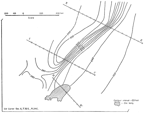
Traverse III-III' (Fig. 1) was run across an unmined part of the Mullen ore body in the SW sec. 6, T. 35 S., R. 24 E. This ore body is about 400 feet deep. In the case of this and other ore bodies, the approximate shape of the ore body is shown on the illustrations by the shaded areas.
Traverse IV-IV' (Fig. 2) crosses an unmined part of the Foley ore body in the NW sec. 7, T. 35 S., R. 24 E.
Figure 2--Location of traverses IV-IV' and V-V' in the W2 sec. 7, T. 35 S., R. 24 E.
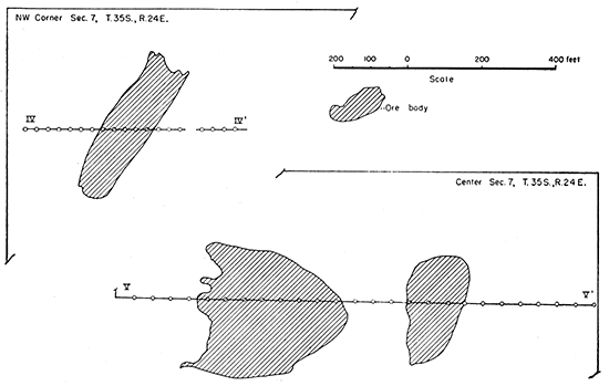
Traverse V-V' (Fig. 2) was made across unmined ore bodies about 300 feet below the surface on the West Side property in the SW sec. 7, T. 35 S., R. 24 E.
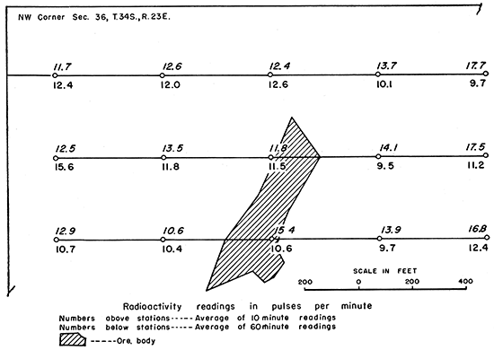
A grid was run across ore bodies on the Garrett property in the NW sec. 36, T. 34 S., R. 23 E. (Fig. 3), where the ore is about 400 feet deep. This area was selected because it has not been disturbed by mining operations.
Figure 3--Radioactivity map of the NW cor. sec. 36, T. 34 S., R. 23 E.
The radioactivity surveys were made by counting pulses on a portable Geiger-Muller counter at each traverse station for a definite time interval. Since the radioactive emanations do not strike the counter at a constant rate, a relatively long count must be made to obtain a representative average rate. Furthermore, cosmic rays also actuate the counter and their rate of incidence likewise is not constant. If a body is highly radioactive, the effect of the variability in the rate of incidence of cosmic rays is so small that it is negligible. If, however, the rate of emission of radioactive rays from a body is, at most, very small, the variability in the rate of incidence of cosmic rays might be great enough to mask any effect of radioactivity of the body for which exploration is being conducted. The only way to reduce the large probable error resulting from the variations in the rate of incidence of radioactive and cosmic rays is to take readings over a long period of time. It can be shown statistically that, where the radioactive rays are emitted from a body at a rate only slightly greater than the rate of incidence of cosmic rays, a count of many hours would be needed to reduce the probable error to a reasonable level. From the point of view of geologic prospecting, such a long reading is impractical. Therefore, an attempt was made to use shorter time intervals and to ascertain whether, in spite of the recognized and known large probable error, recognizable trends could be discerned over structures and ore bodies. At first, 10 minute stations were used; later, the time at each station was increased to 60 minutes.
The voltage of the counter was adjusted so that the counter could be calibrated to within a 5 percent error each day by lengthy readings against a radioactive standard. Large numbers of cosmic ray readings were taken to secure average, maximum, and minimum values.
Extended cosmic ray counts indicate the range of incidence to be from 8 to 20 counts per minute with an average of 10 to 12. An examination of the radioactivity traverses (Figs. 3 and 4) shows no count beyond that which could be attributed to variation in cosmic ray incidence, In this connection, it may be noted that the results from the 1-hour traverses show no better geologic correlation than those from 10-minute traverses. Moreover, because of the relatively large variation in the rate of incidence of cosmic rays, readings taken at the same stations at different times do not duplicate each other. Radioactivity traverses I-I' and II-II' (Fig. 4) show no relation to the pronounced underlying structure. Traverses III-III', IV-IV', and V-V' as well as the grid on the Garrett area (Figs. 3 and 4) show no relation to the underlying ore bodies.
Figure 4--Radioactivity traverses. The different types of lines on each traverse represent the same traverse run on different days.
Traverses made underground across the Mullen trough likewise showed negative results, Traverses also were made underground toward ore bodies containing large amounts of lead and zinc sulfides and their associated minerals, but no radioactive effect was noted--even immediately adjacent to these ore bodies.
It is thus apparent that the values plotted for the radioactivity traverses (Figs. 3 and 4) represent mainly variations in cosmic ray incidence and have, seemingly, no relationship to ore bodies or related structures.
It is conceivable that radioactivity surveys using some instrument other than a Geiger-Muller counter may be able to locate structures or ore bodies in the Tri-State district, It can be stated, however, that the Geiger-Muller counter appears to be of no value either in locating ore bodies or in delineating major structural features in the Tri-State district.
Jakosky, J. J., Dreyer, R. M., and Wilson, C. H., 1942, Geophysical investigations in the Tri-State zinc and lead mining district: Kansas Geol. Survey, Bull. 44, pp, 1-151, figs. 1-55, pls. 1-2. [available online]
Kansas Geological Survey, Radioactivity Surveys, Tri-State Zinc and Lead Mining District, Cherokee County, Kansa
Placed on web Sept. 12, 2016; originally published April 1, 1948.
Comments to webadmin@kgs.ku.edu
The URL for this page is http://www.kgs.ku.edu/Publications/Bulletins/76_5/index.html