![]()
Prev Page--Stratigraphy, Pennsylvanian || Next Page--Structural Development
Stratigraphy, continued
Rocks of Permian Age
The Permian rocks of Kansas are divided into the following series listed in descending order: Guadalupian, Leonardian, and Wolfcampian.
Permian rocks are separated from Pennsylvanian by a low angular unconformity and an erosional surface of high relief in some areas. They are separated from the overlying Cretaceous by an angular unconformity representing a long hiatus, during which hundreds of feet of Permian rocks were eroded.
Wolfcampian Series
The Wolfcampian Series is divided into the following groups listed in descending sequence: Chase, Council Grove, and Admire.
Admire Group
The formations of the Admire group listed in descending order in Table 15 have been differentiated in outcrops in eastern Kansas. The thicknesses at outcrops in eastern Kansas are reported by Moore, Frye, and Jewett (1944, pp. 168-170); those in southeastern Nebraska by Condra and Reed (1943, pp. 36-37).
Table 15--Sequence and thickness of formations of the Admire group.
| Range of thickness in Kansas outcrops, in feet |
Average thickness in Kansas outcrops, in feet |
Range of thickness in southeastern Nebraska, in feet |
||
|---|---|---|---|---|
| Admire group | ||||
| Hamlin shale | 50 | 50 | 48-50 | |
| Five Point limestone | 1-5 | 3 | 1-5 | |
| West Branch shale | 10-30 | 20 | 30 | |
| Falls City limestone | 3-10 | 7 | 9 | |
| Hawxby shale | 12-40 | 30 | 10-12 | |
| Aspinwall limestone | 1-8 | 5 | 1-3 | |
| Towle shale | 15-135 | 30 | 10-50 | |
| Total | 145 | Aver. 134 | ||
The Admire group, exclusive of the basal sandstone, is dominantly shale, some of which is sandy. The limestone beds, although persistent, are thin and without unique lithologic features that aid in their identification in the subsurface.
The Towle shale includes the Indian Cave sandstone member, which fills deep channels cut in the surface of the Pennsylvanian rocks during the hiatus between deposition of the Wabaunsee and Admire groups. Channels filled with Indian Cave sandstone 120 feet thick are exposed in outcrops. The sandstone is reported (Harned and Chelikowsky, 1945) to be in contact with the Auburn shale below the Reading limestone in Pottawatomie County. In the subsurface, the details of topography of the surface between the Pennsylvanian and the Permian are less clearly revealed and give the impression of a mature erosional surface. Except in steep-sided channels the basal beds of the Towle consist mainly of sandy or silty shale. Toward the northwest, thin limestones or indurated shales occur in the Towle shale in the subsurface.
The Aspinwall limestone is the first persistent limestone above the base of the Admire. On account of the unconformity at the base of the Admire, the thickness of the Permian below the Aspinwall varies greatly. Comparison of the interval from the Aspinwall to datum beds such as the Dover and Tarkio limestones in the Wabaunsee below the unconformity, reveals a decrease in thickness toward the west or northwest. The regular thinning of this interval is the basis for the conclusion that regional deformation continued in the same general pattern during the hiatus represented by the interval, as during Pennsylvanian time when areas toward the north and west were continually tilted by differential movements toward the southeast.
The Falls City and Five Point limestones, together with a lenticular limestone locally recognized in the West Branch shale, appear in logs in the Salina basin as a limestone sequence in which the shale partings are generally recognized only in electric logs.
The part of the Admire group above the base of the Aspinwall limestone varies in thickness. It is 90 feet thick to the east of and on the crest of the Nemaha anticline, thickens gradually to 140 feet in the synclinal area of the Salina basin, and thins again northwestward. Abnormal thickening toward the northwest occurs in the upper shale member of the Hamlin shale and also in the West Branch shale. Toward the northwest, the interval between the Falls City-Five Point limestone sequence and the top of the Admire thins, and toward the southeast the same interval increases.
Council Grove Group
The following formations of the Council Grove group, listed in descending order in Table 16, have been differentiated in outcrops in Kansas. The thicknesses at outcrops in Kansas are from Moore, Frye, and Jewett (1944, pp. 165-168). Those for Nebraska are from Condra and Reed (1943, pp. 33-36).
Table 16--Sequence and thickness of formations of the Council Grove group.
| Range of thickness in Kansas outcrops, in feet |
Average thickness in Kansas outcrops, in feet |
Average thickness in southeastern Nebraska, in feet |
||
|---|---|---|---|---|
| Council Grove group | ||||
| Speiser shale | 18-35 | 25 | 19 | |
| Funston limestone | 5-11 | 8 | 8 | |
| Blue Rapids shale | 16-25 | 20 | 22 | |
| Crouse limestone | 10-13 | 12 | 11 | |
| Easly Creek shale | 15 | 15 | 14 | |
| Bader limestone | 18-25 | 23 | 24 | |
| Stearns shale | 8-20 | 14 | 17 | |
| Beattie limestone | 15-20 | 18 | 18 | |
| Eskridge shale | 37 | 37 | 50 | |
| Grenola limestone | 38 | 38 | 33 | |
| Roca shale | 20 | 20 | 23 | |
| Red Eagle limestone | 18-20 | 19 | 11 | |
| Johnson shale | 16-25 | 20 | 19 | |
| Foraker limestone | 50 | 50 | 46 | |
| Total | 319 | 315 | ||
The alternation of well-defined limestones and shales of the Council Grove group is in sharp contrast to that of thin limestones and dominant shales of the Admire group. The group consists of equal proportions of shale, a large part of which is red, and of limestone, much of which is impure and shaly. There is seldom any doubt as to the identity and position of the Foraker and Grenola limestones or the Eskridge and the Speiser shales. The limits of some of the intervening beds are obscure, partly because some of the limestones are soft and argillaceous and some of the shales are calcareous, and partly because such formations as the Funston, Crouse, Bader, and Beattie limestones consist of relatively thin limestones interstratified with shale members. These limestones are more clearly recognized in the samples of some wells than in others.
The Foraker limestone, at the base of the Council Grove group, consists of two more or less prominent limestone members separated by a calcareous shale containing fusulines in such abundance that the Foraker stands out prominently in the subsurface of the Salina basin from other formations in which the fusulines are a less conspicuous feature. The Foraker becomes more calcareous southward and the middle member as well as the upper and lower members is limestone in outcrops in southern Kansas and in Oklahoma. This relation contrasts with the limestones in the Pennsylvanian, which toward the south commonly become argillaceous or interfinger with clastic sediments.
The Red Eagle limestone, like the Foraker, consists of upper and lower limestone members separated by a shale member and, like the Foraker, becomes a single limestone ledge in the outcrops of southern Kansas. In the outcrops it thins slightly toward the north. Although recognized in the subsurface, the limits of the Red Eagle limestone are generally not clearly defined in sample logs.
The Grenola limestone can be identified in most sample logs. The upper member, the Neva limestone, is clearly recognized, but the lower member, the Burr limestone which is interstratified with shale, is obscure.
The Eskridge consists mainly of red shale, although it includes some gray shale. In some localities in the subsurface the shale is interstratified with calcareous beds. The Eskridge is consistently reported in all drillers logs and is easily recognized in sample logs. It is the most reliable datum bed in the lower Permian in spite of the fact that the Roca, Stearns, Easly Creek, and Speiser shales also include red shale. None of these shales is so consistently thick or so consistently red as the Eskridge.
The Beattie and Bader limestones, as represented in drillers and sample logs, are indistinct in many wells probably because they, together with the thin intervening Stearns shale, contain as much shale and impure limestone as pure limestone. The Cottonwood limestone member of the Beattie limestone, which immediately overlies the Eskridge shale, is nearly always recognized.
The Easly Creek shale consists mainly of red and gray shales. It includes some gypsum near the base. This is the first appearance in the Permian of evaporites which constitute a large proportion of the deposits of the upper part of the Permian.
Neither the Crouse limestone nor the Funston limestone is consistently recognized in sample logs, probably because they include much impure limestone and calcareous shale.
The Speiser shale consists of shales and streaks of limestone. The lower part includes much red shale. It is generally revealed in logs as a red shale below the conspicuously cherty Wreford limestone of the Chase group.
The thickness of the Council Grove group is singularly constant. It averages about 319 feet in the outcrops in eastern Kansas and 315 feet in southeastern Nebraska. The thickness of the group is 290 feet just west of the Nemaha anticline. It thickens to 340 feet in the Salina basin and continues northwest without thinning.
Chase Group
The formations of the Chase group, listed in descending order in Table 17, have been differentiated in outcrops in Kansas. The thicknesses of these formations at the outcrops are reported by Moore, Frye, and Jewett (1944, pp. 160-168). Those in Nebraska are reported by Condra and Reed (1943, pp. 31-33).
Table 17--Sequence and thickness of formations of the Chase group.
| Range of thickness in Kansas outcrops, in feet |
Average thickness in Kansas outcrops, in feet |
Average thickness in southeastern Nebraska, in feet |
||
|---|---|---|---|---|
| Chase group | ||||
| Nolans limestone | 22-40 | 34 | 28 | |
| Odell shale | 20-40 | 30 | 34 | |
| Winfield limestone | 28 | 28 | 21 | |
| Doyle shale | 80 | 80 | 59 | |
| Barneston limestone | 80-90 | 84 | 60 | |
| Matfield shale | 60-90 | 78 | 62 | |
| Wreford limestone | 30-40 | 35 | 30 | |
| Total | 369 | 294 | ||
The Chase group consists of a sequence of alternating thick limestones and shales. The limestones constitute approximately 50 percent of this group in outcrops. Northward into southeastern Nebraska the proportion of shale and limestone is approximately the same although both limestones and shales become thinner.
The Wreford limestone consists of two limestone beds separated by a shale bed. Because both are consistently cherty in outcrops and in the subsurface, the Wreford is an excellent datum bed.
The Matfield shale is varicolored. It includes the Kinney limestone member consisting of interstratified shale and thin limestone beds, one or another of which is commonly overlooked in drilling and not accurately represented in sample logs.
The Barneston limestone includes the Florence limestone member at the base and the Fort Riley limestone member at the top separated by a gray calcareous shale member generally not differentiated in logs. The Florence limestone member is conspicuously cherty both at outcrops and in the subsurface. Careful search of samples from the Fort Riley or the Florence member practically always reveals fusulines, many of which in the Florence member are silicified. The Fort Riley limestone is noncherty and contains the youngest fusulines known in Kansas. The two chert-bearing beds, the Florence and the Wreford, are valuable markers in a sequence of limestones and shales whose identification might otherwise remain obscure.
The Doyle shale is variegated and in part calcareous. The Towanda limestone member of the Doyle occurs 20 to 30 feet above its base. Fossils are rare in the outcrops. In the subsurface toward the northwest the Towanda becomes dolomitic and in Phillips County consists entirely of anhydrite.
The Winfield limestone in outcrops in northern Kansas consists of upper and lower limestone members separated by shale. Toward the northwest it becomes dolomitic. Unlike the Pennsylvanian limestones, the shale member of the Winfield thins or grades into limestone toward the south and in southern Kansas the Winfield consists of a single bed of limestone. The lower member of the Winfield is cherty in outcrops but chert is not present in all wells in the subsurface.
The Odell shale, like the other shales of the Chase group, is variegated in color with red predominating.
The Nolans limestone consists of two thin limestones at the base, generally not recognized in logs, and the more prominent and thicker Herington limestone at the top. The intervening shale member is calcareous and includes some limestone in southern Kansas outcrops. The Nolans limestone thickens toward the northwest and grades into dolomite. The limestones become dolomitic toward the west.
The limestones and shales of the Chase group, as represented in the subsurface in well logs, are somewhat more variable in thickness than in outcrops. This is probably due more to imperfections in the logs and samples than to sharp fluctuations in the thickness of the formations, although these also may occur. Red shales are not uncommon in the upper Pennsylvanian but they are increasingly prominent in the Council Grove group and make up a still larger proportion of the shales of the Chase group. Toward the northwest the limestones above the Barneston grade into dolomite and some anhydrite begins to appear with the dolomite.
The total average thickness of the Chase group in outcrops in Kansas is 369 feet. The average thickness of the Chase in southeastern Nebraska is 294 feet. The overall thickness of the Chase in well 43 of cross section X-X' (Pl. 13) in northern McPherson County is 360 feet. In well 38 in Phillips County the thickness is only 290 feet. The Chase group as a whole thus thins toward the northwest like the older Permian and Pennsylvanian groups but the southward increase in the proportion of limestone in some formations is a new feature in the sedimentation of the region.
Leonardian Series
The Leonardian Series is divided into the following, groups listed in descending sequence: Nippewalla and Sumner.
Sumner Group
The following formations of the Sumner group, listed in descending order, have been differentiated by the Kansas Geological Survey in outcrops in east-central Kansas (Moore, Frye, and Jewett, 1944): Stone Corral dolomite, Ninnescah shale, and Wellington formation.
Other groupings of these rocks have been made. Norton (1939) places the Ninnescah and Stone Corral in the redbed sequence at the base of the "Cimarron series" described by Cragin (1896). The base of the Wellington was at one time placed at the Hollenberg limestone member of the Wellington, some 50 feet above the Herington limestone member of the Nolans limestone.
The Sumner group comprises a sequence of evaporites and shale with a few local more or less discontinuous thin limestones of variable character. The upper part consists mainly of shale and the lower part in central Kansas consists largely of shale, anhydrite, and salt.
Wellington formation--A detailed study of the Wellington formation in south-central Kansas was made by Ver Wiebe (1937) who traced the beds of limestone in the outcrops. The Hollenberg is the only one of these limestones recognized with confidence in the subsurface of the Salina basin but others may be present. In the subsurface, Ver Wiebe distinguished five zones, based on lithologic changes, which he correlated with the outcrops. These five zones in descending order are: upper gray beds, red beds, middle gray beds, salt beds, and anhydrite beds. These zones are all recognizable in the subsurface of the Salina basin.
The "anhydrite zone" at the base of the Wellington (known also as the Pearl shale) comprises a sequence of gray shales alternating with anhydrite beds. In the Salina basin it includes the Hollenberg limestone member, 20 to 40 feet above the base, and the overlying beds of shale and anhydrite 130 to 150 feet thick. Toward the east these beds consist mainly of gray shale but toward the west anhydrite predominates. The Hollenberg limestone of the central area of the Salina basin becomes irregularly dolomitic toward the west and probably grades northwestward into one of the anhydrite beds of this zone. Some varicolored shale occurs in this zone below the Hollenberg.
The "salt zone," known as the Hutchinson salt member, consists mainly of salt interstratified with thin beds and laminae of anhydrite and shale partings of no great thickness. Thicker shale beds are interbedded with the salt near the base and near the top. The salt zone is thickest in Russell, Ellsworth, Rice, and Reno counties and thins somewhat irregularly to a featheredge toward the north and west. It thins toward the south in Kansas and extends into northern Oklahoma. Eastward, the salt and most of the associated anhydrite have been dissolved by surface waters for a distance of 20 to 30 miles down dip from the belt in which it should normally outcrop. The removal of the salt has allowed the overlying deposits to slump into a zone of steep dips and confused bedding.
The combined thicknesses of the parts of the Wellington above and below the salt lentil are essentially the same as outside the area of salt deposition. The salt therefore accumulated in a basin formed by the downwarping of the nearly flat surface of the "anhydrite zone."
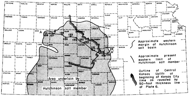
Figure 7 shows the approximate limits of the salt basin, after Bass (1926), modified by the addition of more recent data from Norton (1939), the Gulf Oil Corporation to 1942, and Botinelly. The cross section (Fig. 7) shows the lenticular character of the salt sequence and the attitude of the salt and overlying beds at the end of Wellington time along the line of the Kellett cross section (1932) which traverses the central part of the salt lens. Inasmuch as the unleached salt areas show no definite thinning toward the east, it seems probable that at least half the original salt body has been lost by erosion and leaching. The "middle gray beds" of Ver Wiebe, which occur normally above the salt, include much less anhydrite and more thin red shales than the "anhydrite zone" below the salt. In the absence of the salt the middle gray beds cannot be clearly distinguished from the anhydrite beds.
Fig. 7--Stratigraphic cross section of the Sumner group of the Permian (after Kellet, 1932) on line A-A' of insert showing eastward thickening of the Hutchinson salt member of the Wellington formation and an inset showing the salt basin crossing the Central Kansas uplift. The wells are correlated on the top of the Stone Corral dolomite. The numbers of the wells are the same as those used on the original Kellett cross section. The cross section reveals that the salt lens originally extended a considerable but undeterminable distance to the east or southeast. The Central Kansas uplift which had been a positive and rising area since St. Peter time, was a subsiding area during this interval. The present attitude of the salt in the Salina basin is shown on cross sections X-X' and Y-Y' (Pls. 13 and 14) and on the original Kellett cross section. A larger version of this figure is available.
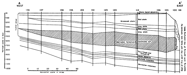
The "red beds" zone is known mainly from wells although Ver Wiebe reports outcrops in southern Kansas where the shale beds thicken appreciably southward. In the Salina basin the thickness of the red beds zone averages about 50 feet. The thickness increases irregularly to more than 100 feet toward the west and northwest.
The "upper gray beds" consist largely of soft gray clays but blue shales are common. Ver Wiebe reports a thickness of 75 feet for these beds in south-central Kansas but in the Salina basin their thickness ranges from 30 to 60 feet. Westward these beds become thicker or grade into the increasingly thick red beds zone. The thin Milan limestone at the top of the Wellington in outcrops was not recognized in the subsurface.
Ninnescah shale--The Ninnescah shale was named by Norton (1939) and described from outcrops in Kingman and Reno Counties as consisting predominantly of red shale with minor amounts of gray shale and thin impure limestones and calcareous sand. It thins rapidly northward from 425 feet near the Kansas-Oklahoma line to 280 feet 50 miles farther north. None of the datum beds recognized in southern Kansas has been identified in the subsurface of the Salina basin where the Ninnescah, although it locally includes some red sandstone, consists in most areas almost entirely of red partly silty shale. The thickness of the Ninnescah in the Salina basin decreases somewhat irregularly toward the north from about 300 feet in east-central Rice County to 65 feet in southeastern Smith County. Westward it thickens irregularly from 65 feet in Smith County to 200 feet in south-central Phillips County and 140 feet in Norton County (Norton, 1939).
Stone Corral dolomite--This formation of dolomite and anhydrite is the youngest deposit of the Sumner group. It was formerly known as the Cimarron anhydrite but was more appropriately named by Norton (1939). It varies in character from place to place along the outcrops and in the subsurface. In some places dolomite predominates. At others it is interstratified with thin shale members and anhydrite and in some places it consists of anhydrite alone. The formation is 30 to 50 feet thick in Pratt, Stafford, and Rice counties. Southeastward in Kingman County it thins to 10 feet and in northern Oklahoma it grades gradually into clastic sediments.
In the Salina basin the thickness ranges from 10 to 50 feet without notable trends of thickening in any direction. Where the Stone Corral is thin it consists almost entirely of anhydrite. Norton (1939) concluded that the Stone Corral is conformable on the underlying Ninnescah but suggests that there may be a minor unconformity at its top.
Nippewalla Group
The following formations of the Nippewalla group in descending sequence have been differentiated in outcrops in southern Kansas: Dog Creek shale, Blaine formation, Flowerpot shale, Cedar Hills sandstone, Salt Plain formation, and Harper sandstone.
All the formations of this group above the Harper sandstone, as well as the entire overlying Guadalupian Series, were eroded from the Salina basin during the hiatus preceding Cretaceous deposition.
In the outcrops the Harper sandstone is divided into the Chickaskia and Kingman sandstone members, both of which consist chiefly of red sandstone broken by thin beds of red shale and white sandstone. Subsurface cross sections published by Norton (1939) show that the sandstone members, so prominent in the outcrops, are less conspicuous and more irregular in the subsurface. This may be due in large part to the fact that grains of disintegrated sandstone are frequently lost in the cuttings from rotary wells. In the subsurface of the western part of the Salina basin, the Stone Corral is overlain by red shale, sandy shale, and sandy micaceous shale. The sandstone members of the Harper sandstone, although they may be present, cannot be differentiated in the cuttings of the wells examined. Rocks classified as of Harper age have a thickness of 300 feet in sec. 13, T. 5 S., R. 18 W. These rocks may include some undifferentiated red shales in the base of the Salt Plain formation. Eastward the sandy shales of the Harper are truncated by Cretaceous rocks.
Rocks of Cretaceous Age
The following Cretaceous rocks, listed in descending sequence, have been differentiated in outcrops in central and western Kansas.
| Cretaceous System | |||
| Gulfian Series | |||
| Montana group | |||
| Pierre shale | |||
| Colorado group | |||
| Niobrara chalk | |||
| Carlile shale | |||
| Greenhorn limestone | |||
| Graneros shale | |||
| Dakota formation | |||
| Comanchean Series | |||
| Kiowa shale | |||
| Cheyenne sandstone | |||
The Cretaceous rocks lie on the beveled edges of the Permian rocks. The formations of Permian age younger than Harper sandstone and all rocks of Triassic and Jurassic age are absent. Probably the uppermost Permian rocks of southwestern Kansas extended throughout this part of Kansas and were later eroded. Deposits of Triassic and Jurassic age, themselves separated by unconformities, are recognizable in western Kansas. If they extended eastward into the Salina basin, they were completely removed later.
The land surface across which the Cretaceous sea advanced had a mature relief sloping at a low angle toward the west. The local relief of this surface within a single county was at least 50 feet. The regional relief as shown by the Kellett cross section (1932) was more than 300 feet.
The Niobrara chalk and older Cretaceous rocks are exposed on the western border of the Salina basin. Eastward they and the upper formations of the Cretaceous were removed by erosion and only the Dakota sandstone extends as far east as Washington County.
Detailed studies of the Cretaceous rocks in central Kansas have been made in recent years by several geologists of the State Geological Survey. Plummer and Romary (1942) examined the Dakota formation from Ellsworth County northeast to Washington County by means of open cuts for the purpose of studying the clays. Frye and Brazil (1943) studied the Cretaceous section in outcrops and in test holes drilled in Ellis and Russell Counties in connection with ground-water studies. Swineford and Williams (1945) examined cuttings from many test wells in Russell County in the study of salt-water disposal problems. These reports, all of which deal with the Cretaceous within or bordering the Salina basin, have been drawn upon for descriptions of the subsurface character and thickness of the Cretaceous formations.
Comanchean Series
The Cheyenne sandstone is the basal deposit of the Cretaceous throughout most of western Kansas. It is reported above Morrison shale of Jurassic age in Norton County by Norton (1939) and in Gove County by Kellett (1932), but east of these areas the Cheyenne rests on the Permian. The Cheyenne sandstone consists predominantly of buff to light-gray sandstone with small amounts of shale and siltstone, These clastic materials were derived in large part from exposed Permian rocks reworked by wave action of the eastwardly advancing sea. Their characteristics in Russell County (Swineford and Williams, 1945, p. 130) and probably elsewhere vary with the character of the rocks exposed on the underlying surface and in bordering areas. They are characterized by relatively coarse sand, absence of shell fragments, and absence of mica in the coarser facies. The Cheyenne has a thickness of 200 feet in Ellis County. In Russell County it ranges in thickness from a featheredge, where it overlaps upon topographic highs, to 62 feet. It wedges out on the surface of the Permian east of Russell County.
The Kiowa shale consists of gray to black thinly laminated shale interbedded with lenticular bodies of thin white siltstone and sandstone. Locally the sandstone lentils are as much as 20 feet thick. Shell fragments and carbonaceous material are common. The sandstones are slightly glauconitic, generally micaceous, and less coarse in grain than the sands of the overlying Dakota. The thickness of the Kiowa in Russell County ranges from 50 to 100 feet. The thinner deposits overlie hills of the Permian surface. The Kiowa overlaps the Cheyenne and thins out toward the east. It is absent in outcrops north of Ottawa County.
Gulfian Series
Colorado Group
The Dakota formation is composed dominantly of varicolored clay. It includes some siltstone but very little shale. Fine- and coarse-grained sandstones are frequent but discontinuous. They are mainly channel deposits and only a few can be traced from place to place. In spite of their prominence in outcrops, the sandstones constitute only a minor element in the Dakota sequence. Siderite in concretions and pellets is abundant. Hematite, limonite, and carbonaceous material of various kinds are common. Lateral variation of all lithologic types is pronounced. Plummer and Romary (1942) report that the sediments are nonmarine and were seemingly deposited near sea level under conditions somewhat analogous to present conditions in the lower Mississippi delta. Careful measurements by Plummer and Romary (1942, fig. 4) at intervals from Ellis County northeast to Washington County reveal thicknesses of 270 feet in southern Ottawa County where the Dakota overlies the Kiowa shale and 190 feet in Washington County where the Dakota overlaps onto the Permian. The thickness of the Dakota in Russell County ranges from 213 feet to 300 feet.
The Graneros shale in Russell County consists of dark-gray to brownish-black noncalcareous shale interbedded with thin beds of glauconitic fine-grained sandstone. It is distinguished from the overlying Greenhorn limestone by the absence in the Graneros shale of calcareous material and the foraminifer Globigerina and by the presence of sheets of sandstone and siltstone. It is distinguished from the underlying Dakota by the occurrence of glauconite and pyrite in the Graneros, and by the absence of kaolin and siderite (Swineford and Williams, 1945). The thickness of the Graneros shale in Russell County ranges from 14 to 40 feet.
The Greenhorn limestone in Russell County consists of alternating beds of limestone and chalky shale. The upper limestone beds are chalky and not readily separated lithologically from the overlying Carlile shale. The lower beds are crystalline. Shell fragments and Globigerina are common in the cuttings. Some bentonite occurs in the lower part of the formation. The Greenhorn limestone is 85 to 110 feet thick in Ellis and Russell counties.
The Carlile shale is divided into three dissimilar lithologic units. The lower third, the Fairport chalky shale member, about 100 feet thick, consists of thin beds of chalky limestone separated with difficulty from the similar upper beds of the Greenhorn limestone. Most of the upper two-thirds of the Carlile, the Blue Hill shale member, 175 feet to 215 feet thick, is made up largely of gray-black fissile shale. At the top lies a sandstone member, the Codell sandstone, a few inches to 20 feet thick. Bass (1926a) reports that the Carlile shale in Ellis County is approximately 300 feet thick.
The Niobrara chalk is a thick sequence of alternating chalk and marl. The lower member, the Fort Hays limestone, averages about 55 feet in thickness and includes chalky limestone somewhat harder than the overlying rocks. The upper member, the Smoky Hill limestone, ranges from 450 to 700 feet in thickness. It consists mainly of chalk and marl interstratified with thin beds of chalky shale and frequent partings of bentonite up to 6 inches thick. The total thickness of the Niobrara is 500 to 750 feet in the subsurface of Logan and Wallace counties where it is overlain by the Pierre shale. Only the lower part of the Niobrara is represented on the western border of the Salina basin where its thickness is less than 300 feet.
The condition of available rotary samples of the Cretaceous on the western margin of the Salina basin does not permit accurate determination of the contacts of the various Cretaceous formations. The contacts are so indefinite in some wells that the Cretaceous sequence cannot be subdivided.
Rocks of Tertiary and Quaternary Age
Tertiary deposits of continental origin occur in many localities in central Kansas. The Emma Creek formation of Pliocene and early Pleistocene age, which consists of alluvial deposits of sand, silt, and clay, is found in thicknesses up to 180 feet in parts of McPherson and adjacent counties (Moore, Frye, and Jewett, 1944, p. 148).
Quaternary deposits of Pleistocene and Recent age are also present in central Kansas. Sand, gravel, silt, and clay up to 150 feet thick occur in places in McPherson and Republic counties and fill pre-glacial or early Pleistocene valleys. Glacial till mantles the uplands in the northeastern part of the Salina basin. Loess deposits mantle extensive upland areas throughout the region. High-level terraces of different ages occur on the borders of ancient and recent valleys.
Prev Page--Stratigraphy, Pennsylvanian || Next Page--Structural Development
Kansas Geological Survey, Geology
Placed on web Dec. 28, 2007; originally published Nov. 1948.
Comments to webadmin@kgs.ku.edu
The URL for this page is http://www.kgs.ku.edu/Publications/Bulletins/74/03_strat4.html