![]()
Prev Page--Stratigraphy, Pre-Cambrian to Ordovician || Next Page--Stratigraphy, Pennsylvanian
Stratigraphy, continued
Rocks of Silurian Age
The limestones and dolomites lying between the Maquoketa shale and the Chattanooga shale are conveniently referred to as Hunton formation or group by oil operators and many geologists. Study of this sequence has revealed that it consists of rocks of Silurian and Devonian age. Unconformities at the bottom and top of both the Silurian and Devonian have so modified the distribution of the separate parts of the Hunton in Kansas and Oklahoma that either the Silurian or Devonian beds may be present alone or in combination with parts of the other. The term Hunton has thus become ambiguous except in the sense that it includes all the limestone and dolomite rocks between the Maquoketa and Chattanooga shales.
Silurian rocks crop out at intervals from the Arbuckle Mountains in Oklahoma through central Arkansas, thence northward around the Ozark uplift to southeastern Missouri, northeastern Iowa, and parts of adjoining states. These rocks include the Alexandrian Series of Savage (1908) at the base of the Silurian, consisting in ascending order of the Cape Girardeau limestone, Edgewood limestone, and Brassfield or Sexton Creek limestone. In some areas, rocks of Alexandrian age are overlain by the Bainbridge limestone or its correlatives of the next younger Niagaran Series. The oldest of the Silurian rocks in Oklahoma is the Chimneyhill limestone, which includes equivalents of the Noix oolite member of the Edgewood limestone and the Brassfield limestone. In Oklahoma, the Brassfield equivalent is overlain by the Henryhouse shale, which is believed by some geologists to represent the Bainbridge of the Mississippi Valley. Some of the Silurian rocks of north-central Kansas are correlated with the Chimneyhill of Oklahoma (Lee, 1945, pp. 44-45). Younger Silurian rocks may be represented in parts of northeastern Kansas but they have not been differentiated.
The Chimneyhill limestone and its correlatives are widely distributed in the subsurface. It was probably originally deposited throughout the region from the outcrops in the Mississippi Valley across the Ozarks to western Kansas and western Oklahoma. Upwarping and erosion have removed all the Silurian rocks from the crests of anticlinal structures in Kansas such as the Chautauqua arch, the Nemaha anticline, and the Central Kansas uplift, and from comparable structural features in adjoining states.
The Silurian rocks lie unconformably on the Maquoketa except in parts of Smith and Osborne counties where they overlap upon the Kimmswick (Pl. 4), but without determinable angular unconformity. The Devonian is separated from the Silurian by an important unconformity, which not only beveled the Silurian but also all the underlying formations down to the Lower Ordovician dolomites. Pre-Devonian erosion left hills of Silurian dolomite in two areas in Dickinson County. The Devonian rocks probably covered these hills but they were re-exposed by pre-Chattanooga erosion.
In the Salina basin, the Silurian rocks consist chiefly of dolomite but include some limestones. They are conveniently separated into five zones on the basis of physical character, siliceous residues, and foraminiferal remains. The overall thickness of the Silurian rocks in northeastern Kansas ranges from a featheredge to 435 feet in the Lamparter well (well 14, Pl. 3), but their thickness is even greater at places in southeastern Nebraska. The maximum thickness observed in the Salina basin is 315 feet in the Arkansas Fuel Oil Company No. 1 Martin well in sec. 24, T. 8 S., R. 4 E.
Erosion and weathering of the surface of the Silurian rocks in pre-Devonian time probably developed porosity at and near the surface of the exposed rocks. For the most part, the degree of porosity in limestones and dolomites can only be inferred from the abundance of microscopic cavities in the cuttings but small interstitial openings are present in many rocks away from the larger openings. Unfortunately the more important larger pores are not clearly revealed by the cuttings except occasionally when sizable rock fragments are recovered in cores or by chance specimens recovered in drilling. The cavities developed in the Silurian rocks seem to have been rather generally filled and re-cemented later by the circulation of calcareous waters from the overlying Devonian limestone, although in many localities the openings were not completely sealed. In parts of the area the Silurian rocks were re-exposed by pre-Chattanooga erosion and, as the Chattanooga shale is generally not calcareous, the porosity developed in pre-Chattanooga time survived in most places. The tops of the first and second zones where these underlie the Chattanooga shale are generally porous.
Porosity is not confined to the top of the Silurian. In the first zone interstitial openings occur between the oolites in many wells. Throughout the third zone interstitial porosity is general in the deeper part of the North Kansas basin but is less common toward the margin. Porosity of this kind occurs also in the fourth zone to depths of 10 to 60 feet below its contact with the Devonian. It occurs in the middle of the fourth zone in the B. B. Blair No. 1 Cox well in sec. 10, T. 4 S., R. 7 E. and in the basal 15 feet of the zone in the Derby No. 1 Neimoller well in sec. 19, T. 10 S., R. 3 E. The upper 5 feet of the fourth zone is porous in the Ohio Oil Company No. 1 Lamparter well in sec. 3, T. 2 S., R. 14 E. where the fourth zone is overlain by a thick section of the fifth zone.
Oil stains and flecks and stringers of asphalt occur 120 feet below the top of the Silurian in 5 feet of porous dolomite below cherty limestone at the top of the second zone in the Auto-Ordnance Corporation-Helmerich and Payne No. 1 Gekler well in sec. 20, T. 12 S., R. 2 W. Oil stains were also noted 25 feet below the top of the Silurian in 5 feet of dolomite below the chert of the fourth zone in the E. S. Adkins No. 1 Weis well in sec. 32, T. 14 S., R. 2 W.
The five zones into which the Silurian rocks have been divided are described below in ascending order.
First zone--The first zone immediately overlies the Maquoketa shale and extends upward to the top of rocks enclosing dolomitized oolites. It corresponds to the oolitic zone of the report on the Forest City basin in Kansas (Lee, 1943, p. 46). It is composed of crystalline and sucrose dolomite throughout and is characterized by dolomitized oolites which occur in variable amount in different wells and in different parts of the zone, but some parts of the zone have few or none. The oolites are roughly spherical grains composed of sucrose dolomite. The surface of the oolites is rough and in some samples the oolites resemble granular cuttings of soft sucrose dolomite that have become rounded in drilling. Many of the oolites are broken. Some samples from rotary wells expose the oolites touching one another in cross section. The interstitial cavities between the oolites are angular, with concave walls and in some samples these cavities indirectly reveal the oolitic nature of the rock. The concentric banding usual in oolites has been destroyed by re crystallization.
The amount of insoluble residues of the first zone is very small in most wells and consists generally of particles of clear hackly quartz but in the following wells, in all of which this zone is relatively thin (5 to 30 feet), small amounts of oolitic chert were noted: the B. B. Blair No. 1 Cox well in sec. 10, T. 4 S., R. 7 E.; the Wolf Creek Oil Company No. 1 Brenizer well in sec. 35, T. 12 S., R. 2 E.; the Bay Petroleum Corporation No. 1 Rockhold well in sec. 20, T. 13 S., R. 1 W., and the Hutchinson No. 1 Ehrmann well in sec. 15, T. 18 S., R. 1 E.
In general, the first zone becomes thinner toward the southwestern margin of the North Kansas basin but there are local areas in the deeper part of the basin also where it is thin. In the B. B. Blair No. 1 Cox well in sec. 10, T. 4 S., R. 7 E., the first zone is 7 feet thick and in the Carter No. 1 Stratigraphic test in sec. 16, T. 7 S., R. 2 W., it is 10 feet thick. In well 3 of Plate 3 and in other parts of the marginal areas of the basin, it wedges out locally and is overlapped by the second zone. The variation in the thickness and in the abundance of the oolites in the rocks of this zone is probably due to topographic relief on the surface of the Maquoketa. The first zone is absent in some areas but where present ranges from 5 to 65 feet in thickness.
Second zone--The second zone, which is characterized by white chert, extends from the top of the oolitic dolomite to the top of the cherty dolomite. It is the equivalent of the white chert zone described in the adjacent Forest City basin in Kansas. It consists mainly of crystalline dolomite throughout the deeper parts of the North Kansas basin but toward the southwestern margin it is interbedded with increasingly larger proportions of coarse semigranular limestone and earthy limestone, but does not at any place lose all the dolomite. The volume of the white opaque chert in the samples ranges from 5 to 20 percent. Where the second zone is thick the chert occurs in greatest abundance in the upper two-thirds of the zone but where the zone is thin the cherty phase lies on the first zone. The noncherty dolomite beds at the base of the second zone are similar to the dolomite in the underlying oolitic zone except for the absence of oolites. It is possible therefore that this material represents a part of the first zone in which oolites were not developed. The second zone nearly everywhere overlies the oolitic zone but in the Nathan-Jones et al. No. 1 Robertson well in sec. 27, T. 14 S., R. 2 W. (well 3, Pl, 3) and in some other wells near the margin, the second zone, in the absence of the oolitic beds, is in contact with the Maquoketa shale. Anhydrite was noted in minor amounts in the Forest City basin to the east (Lee, 1943, p. 46) but none was detected in the cuttings from the Salina basin. The second zone is the most regular in thickness of the several zones of the Silurian, and for this reason and because its distribution is co-extensive with the Silurian as a whole, its top was used as the datum for correlating the Silurian in the cross sections of Plate 3. Its observed thickness ranges from 27 to 45 feet.
Third zone--The third zone extends from the top of the cherty dolomite of the second zone to the base of a well-developed siliceous zone above. This zone includes the foraminiferal zone described in the Forest City basin report. The foraminiferal zone of that area has no well-defined upper limit and in the Salina basin the third zone is extended upward to the most definite datum, the base of the siliceous rocks of the fourth zone.
The third zone, like so many other units deposited in the North Kansas basin, consists entirely of dolomite in the central part of the basin but is increasingly interstratified with limestone toward the southwestern margin. The dolomite of the third zone is generally sucrose in contrast to the adjacent zones above and below, which are generally granular. The lower 5 to 35 feet of this zone includes, in some wells, minor amounts of interbedded pink and reddish dolomite, pink and red earthy limestone, and white coarsely granular limestones with imbedded pink grains.
Chert is conspicuously absent in the third zone but the residues reveal small amounts of silt rarely exceeding 1 to 2 percent but some samples include as much as 5 or 6 percent of silt with traces of hackly and drusy quartz. The lower part of the zone is characterized by the presence of Foraminifera of species resembling Lituotuba and Ammodiscus described by Ireland (1939) from the Silurian of Oklahoma. The Foraminifera are diffusely distributed in the dolomite and are rarely recognizable in the untreated samples except as tubular fragments on the face of cuttings. The residues from 5-gram samples from the foraminiferal rocks rarely yield more than 5 or 6 specimens and some contain none. The demonstrable thickness of the foraminiferal bed is 95 feet in the Coronado No. 1 Parks well in sec. 16, T. 10 S., R. 8 E. Elsewhere, Foraminifera have rarely been noted more than 40 feet above the base. The lower part of the third zone is marked by the presence of imbedded grains of glauconite.
The third zone is 165 feet, thick in the Ohio Oil Company No. 1 Lamparter well in sec. 3, T. 2 S., R. 14 E. near the center of the North Kansas basin. The thickness decreases with considerable regularity toward the margin of the basin as shown on Plate 3. It is only 55 feet thick in well 4 of the cross section.
Fourth zone--The fourth zone is composed mainly of dolomite but includes minor amounts of interbedded limestone toward the southwest in the usual gradation from central to marginal areas of the North Kansas basin. This zone is siliceous but the insoluble residues, including both quartzose and cherty materials, are extremely variable in character and volume. The quartzose residues consist of quartz crystals, hackly quartz, drusy quartz, siliceous sponge, and silt. The cherty residues of this zone include grainy opaque chert, semiopaque chert, soft white opaque chert resembling tripoli, and in certain areas much varicolored chalcedonic chert.
The quartzose residues which predominate in the basinward areas range in volume from traces to 10 percent, and the quartz crystals are confined to the upper 5 to 40 feet. These materials, particularly the quartz crystals when present, identify the fourth zone in the basinward areas. Toward the margin of the basin the quartzose residues diminish in volume and disappear and the residues become increasingly cherty. Near the western margin of the basin, samples from the fourth zone consist almost entirely of chert much of which is chalcedonic, as in the Carter Oil Company No. 8 Stratigraphic test in sec. 21, T. 11 S., R. 8 W. where the zone is 65 feet thick and in the Dickey Oil Company No. 1 Eckart well in sec. 24, T. 11 S., R. 7 W. where the zone is 75 feet thick.
The fourth zone maintains a regular thickness of 65 to 75 feet. Toward the south and west, however, it has been beveled by pre-Devonian erosion and in some places is cut out in the pre-Chattanooga valley of Marion and McPherson counties.
Fifth zone--The fifth zone consists of interbedded limestone and dolomite, whose insoluble residues are of negligible volume. It attains a maximum known thickness of 140 feet in the Ohio Oil Company No. 1 Lamparter well in sec. 3, T. 2 S., R. 14 E. (well 14, Pl. 3), but it is thinner or absent toward the south and west on account of pre-Devonian beveling.
Rocks of Devonian Age
The outcrops of Devonian rocks nearest to the Salina Basin are in central Missouri where the oldest are of Middle Devonian age (Branson, 1923, pp. 19-47; 1941). Although the Devonian formations appear at the surface in separated outcrops of small thickness, Branson (1944, pp. 131, 151) has determined the following sequence of formations of Middle Devonian age in northern Missouri in ascending order: Cooper limestone, Ashland limestone, and Callaway limestone. These formations are separated from one another by disconformities. The Upper Devonian is represented by the Snyder Creek shale, which lies disconformably on the Callaway in outcrops.
The Cooper limestone of the outcrops consists mainly of bluish-gray lithographic limestone, is sparingly fossiliferous, and encloses sparsely disseminated rounded and frosted grains of sand. The base of the Cooper is nearly everywhere characterized by a bed of sandstone, calcareous sand, or sandy limestone which is useful in determining the base of the Devonian in the subsurface. The Ashland and Callaway limestones are granular and more fossiliferous than the Cooper and only the basal bed of the Cooper just described can be differentiated in the subsurface. The Snyder Creek shale, which is represented only locally at the surface, has not been identified with certainty in the subsurface far from the outcrop.
The lithographic limestone of the Cooper with its basal sandy bed has been traced in the subsurface westward from the outcrops to Douglas and Jefferson counties in northeastern Kansas. Farther north, in the deeper parts of the North Kansas basin, the Cooper limestone and the overlying undifferentiated limestones of probable Callaway age become dolomitic by lateral gradation into, and interfingering with, dolomite beds and thus lose the lithology of the outcrops except that the basal bed is nearly everywhere sandy or includes disseminated grains of rounded or frosted sand. In the deeper parts of the North Kansas basin, the rocks of unquestioned Devonian age, including the basal sandy beds of the Cooper, are dominantly dolomitic but in the southwestern part of the North Kansas basin, which later became the Salina basin, limestone correlated with the Cooper occurs alone or interbedded with dolomite. The Devonian rocks of the Salina basin are divided conveniently into upper and lower zones by a bed of cherty or siliceous dolomite in the top of the lower zone.
The Devonian dolomites and limestones in eastern Kansas, including both the lower and upper zones, have a maximum thickness of 215 feet in the Ohio Oil Company No. 1 Lamparter well (well 14, Pl. 5) although they become considerably thicker in parts of southeastern Nebraska. They are 155 feet thick in the Veeder Supply and Development Company No. 1 Gravenstine well in sec. 21, T. 8 S., R. 6 E. They thin toward the southwest where they are absent in a deep pre-Chattanooga valley in Marion and McPherson counties. The Devonian has a thickness of 30 feet in the Gled No. 1 "B" Franz well (well 2, cross section A-A', Pl. 5) and is generally erratic in thickness or absent toward the southwest on account of pre-Chattanooga topography. It is worthy of comment that, in a number of wells (wells 2, 3, 24, and 28, cross section A-A', Pl. 5), the uppermost Devonian rock is the cherty bed at the top of the lower zone which seems to have offered enough resistance to prevent the erosion of this zone in certain areas.
Pre-Devonian erosion beveled all the rocks from the Jefferson City to the Silurian and reduced the surface of the North Kansas basin to a plain of low relief but the stratigraphic relations of the older rocks to the Devonian were obscured in some areas by post-Devonian erosion. Plate 4 shows the restoration of the pre-Devonian outcrops as they appeared before they were altered by pre-Chattanooga and pre-Pennsylvanian erosion.
Pre-Chattanooga erosion in the North Kansas basin again beveled the rocks, this time from the Jefferson City to the Devonian. Erosion also cut a broad deep valley below the beveled surface in Marion and McPherson counties and left an outlier of Devonian rocks in Harvey County. Plate 5 shows the areal geology of the pre-Chattanooga surface. Inliers of Silurian rocks in Dickinson County represent pre-Devonian hills, originally covered by Devonian rocks but re-exposed by pre-Chattanooga erosion. Post-Mississippian erosion again beveled the region and in some places, as shown on Plate 8, re-exposed the Chattanooga shale and removed or reduced the thickness of the Devonian.
It might be expected that the eroded surface of the Devonian dolomite underlying the unconformable Chattanooga shale or the Pennsylvanian rocks would have developed and preserved a porous zone of weathering. However, many beds of Devonian dolomite are extremely dense and this density except in some parts of the section has prevented the development of porosity in the zone of weathering. Porosity was noted in the upper 40 feet in the Arkansas Fuel Company No. 1 Martin well in sec. 24, T. 8 S., R. 4 E.; in the 10 feet remaining of the pre-Chattanooga erosion in the Auto-Ordnance Corporation-Helmerich and Payne No. 1 Gekler well in sec. 20, T. 12 S., R. 2 W.; and in the thin remnant remaining in the Helmerich and Payne No. 1 Verhage well in sec. 2, T. 7 S., R. 11 W. in which the Devonian dolomite is overlain by Mississippian limestone. Pin point porosity occurs throughout a 30-foot bed of sucrose dolomite, 37 feet below the top of the Devonian dolomite, in the Turner et al. No. 1 Umscheid well in sec. 32, T. 8 S., R. 9 E. Porosity occurs also in the local sandstone immediately underlying the cherty dolomite member of the lower zone in the Scow Bros. No. 1 Gates well in sec. 16, T. 9 S., R. 4 E. and in the sandy slightly dolomitic member near the base of the Devonian dolomite in the same well, where water was reported. Porosity occurs also in many wells where the basal sandy bed is a very sandy dolomite or a dolomitic sand as in the Leeward Petroleum Corporation No. 1 Knight well in sec. 23, T. 13 S., R. 3 E.
Lower zone--The lower zone of the Devonian rocks includes a sandy bed at the base and extends upward to the top of a sequence of cherty beds. In the central part of the North Kansas basin, the lower zone consists of dolomite of sucrose texture, but toward the southwestern margin of the North Kansas basin, as toward the southeastern margin, some limestone is interbedded with the dolomite. In the Phil-Han Oil Company No. 1 Currie well in sec. 10, T. 15 S., R. 1 W., the lower 40 feet of this zone consists of semigranular limestone interbedded with thin sheets of sucrose dolomite. The sandy bed at the base of the lower zone is dolomitic except in a few wells toward the southwestern margin of the North Kansas basin, as in the Currie well in which the sandy bed is calcareous. The imbedded sand grains are rounded and frosted and constitute from a trace to 40 percent of the volume of the sample. Occasional disseminated grains of similar sand occur erratically throughout most of the lower zone. In some places the rocks immediately below the cherty dolomite bed at the top of the lower zone are conspicuously sandy, as in the Scow Bros. et al. No. 1 Gates well, in sec. 16, T. 9 S., R. 4 E., where 20 feet of dolomitic sandstone with some green clay shale immediately underlies the cherty bed. Considerable sand, up to 20 percent of the sample, occurs in a bed 40 to 60 feet above the base of the Devonian in the McLaughlin No. 1 Allen well in sec. 32, T. 8 S., R. 16 E. and sand also occurs in some other wells in varying amounts well above the basal sandy bed.
The bed at the top of the lower zone is cherty dolomite, 10 to 35 feet thick, in which insoluble residues form 10 to 80 percent of the samples. Part of the chert is gray and opaque with textures varying from massive to grainy and part is white and soft and resembles tripoli. The cherty bed in the Turner et al. No. 1 Umscheid well, sec. 32, T. 8 S., R. 9 E., is 15 feet thick. Insoluble residues from the upper 5 feet consist of grainy quartzose chert; from the middle 5 feet, of opaque chert flecked with grainy quartzose chert; and from the lower 5 feet, of opaque chert. The position of the cherty bed above the base of the Devonian and the absence of imbedded sand grains above the chert suggest that it correlates with the quartzose zone of the Forest City basin area to the east (Lee, 1943, pp. 55-56). The thickness of the lower zone ranges from 105 feet in the Ohio Oil Company No. 1 Lamparter well in sec. 3, T. 2 S., R. 14 E. to 30 feet or less on the southern margin of the North Kansas basin where the Devonian rocks were removed by pre-Chattanooga erosion.
Upper zone--The upper zone of the Devonian occurs only in the deeper parts of the North Kansas basin where it was preserved from pre-Chattanooga erosion. It was recognized in the Gulf Oil Corporation No. 1 Baker well in sec. 1, T. 1 S., R. 2 E. where it is 100 feet thick and in the Turner et al. No. 1 Umscheid well in sec. 32, T. 8 S., R. 9 E. where it is 107 feet thick. It has not been observed in the cuttings of wells to the south and west but is generally present to the northeast of these two wells. In the Gulf No. 1 Baker well the upper zone is composed of limestone interbedded with dolomite but in the Turner No. 1 Umscheid well it is composed of dolomite interbedded with minor amounts of pale-green shale in the lower 35 feet of the zone. The presence of this shale, although it is not definitely correlated with the Snyder Creek shale of Missouri or the Independence shale of eastern Iowa, suggests that the beds above the cherty dolomite of the lower zone may be of Late Devonian age. Condra and Reed (1943, p. 62) correlate similar greenish shale of irregular distribution in the subsurface of southeastern Nebraska with the Independence shale. Northeastward from the Baker and Umscheid wells, the upper zone consists mainly of dolomite but thin beds of limestone are interbedded with the dolomite in some places. It varies in thickness owing to the unconformity at its top. The minimum known thickness of this zone is 100 feet in the Baker well. It is 110 feet thick in the Ohio No. 1 Lamparter well in sec. 3, T. 2 S., R 14 E. The maximum thickness, 215 feet, is in the Isaacs et al. No. 1 Magor well in sec 15, T. 5 N., R. 15 E. in southeastern Nebraska.
Rocks of Devonian or Mississippian Age
In eastern Kansas a sequence of black and gray shales of Devonian or Mississippian age separates limestones definitely of Mississippian age from limestones and dolomites definitely of Devonian age. A black shale in southwestern Missouri, earlier called Eureka shale and Noel shale, was renamed the Chattanooga shale by Adams and Ulrich (1905) and it has been correlated with the Grassy Creek shale of northeastern Missouri by Branson (1944, p. 159). The Chattanooga shale thickens to the north and west from the outcrops in southwestern Missouri.
Johnston (1934, p. 15) in describing the stratigraphy of the Hollow pool of Harvey County, Kansas, described this shale sequence between the "Mississippi limestone" and the top of the "Silurian-Devonian group" as interrupted by Chouteau limestone and for this reason he placed the upper part of the shale in the Kinderhookian Series. These correlations are based upon the discovery of Kinderhookian fossils in a dolomite core taken from the McBride No. 4 Abraham Schmidt well in the NE cor. NE sec. 30, T. 22 S., R. 3 W. in Harvey County. [Note: The core was taken below 79 feet of shale and above 7 or 8 feet of black shale crowded with spores typical of the basal Chattanooga. Casing in this well was set and cemented at 3,431 feet, 71 feet below the top of the shale. The sample from a depth of 3,436 feet, taken after the casing was cemented, consisted entirely of cement and a few fragments of dark shale. A cored sample was taken between the depths of 3,438 and 3,442 feet. The sample representing the first 2 feet consisted of fossiliferous dolomite interlaminated with dense limestone and that representing the second 2 feet, not seen by the writer, is described as sand and sandy shale reported as "Misener sand." Drill cuttings below 3,442 feet reveal black shale with spores typical of the basal Chattanooga above the Misener. Devonian limestone was encountered at 3,449 or 3,450 feet. The fossiliferous samples from 3,438 to 3,440 feet, lent by Sinclair Prairie Oil Company, were examined in 1946 by L. R. Laudon and R. C. Moore of the Kansas Geological Survey, who agree on the Kinderhookian age of the fossils.] It seems probable, however, that the fossiliferous material was not in place when cored, that the dolomite of the sample represents pieces knocked from the base of the Mississippian limestone above the shale when the casing was run, and that after cementation, it was this material at the bottom of the hole below the pipe that was cored. This conclusion is based on the following considerations: (1) the presence of cavings below the cement is revealed by the fact that the first cuttings below the cement include fragments of opaque white chert of the Burlington-Keokuk type not known in the Kinderhookian, and traces of the Kinderhookian Gilmore City oolitic limestone commonly found in wells in this area immediately above the Sedalia and above the Chattanooga; (2) dolomite lithologically identical with the fossiliferous cores occurs immediately above the shale sequence in parts of Harvey and McPherson Counties (Fig. 5A); (3) dolomite of this character has not been found within the shale sequence in Harvey and adjoining counties where many clean samples from wells drilled by cable tools have been examined by the authors; (4) the occurrence of Kinderhookian dolomite within the shale sequence is incompatible with the regional relations and distribution of the Kinderhookian limestone as described in a subsequent section of this report.
Near the Missouri-Nebraska line, the Chattanooga shale in some wells is overlain by red and pink shales locally interstratified with green shale. In some wells the red shales include concentrations of red oolites or fine ironstone pellets. These shales and the underlying oolitic bed are not known to crop out anywhere at the surface. They are particularly well developed in the subsurface of southeastern Nebraska where they were penetrated in many wells during the development of the Falls City oil field, but they occur also in adjoining parts of Missouri and Kansas and in southwestern Iowa. Reed (1946) has proposed the name Boice shale for this formation.
Chattanooga Shale
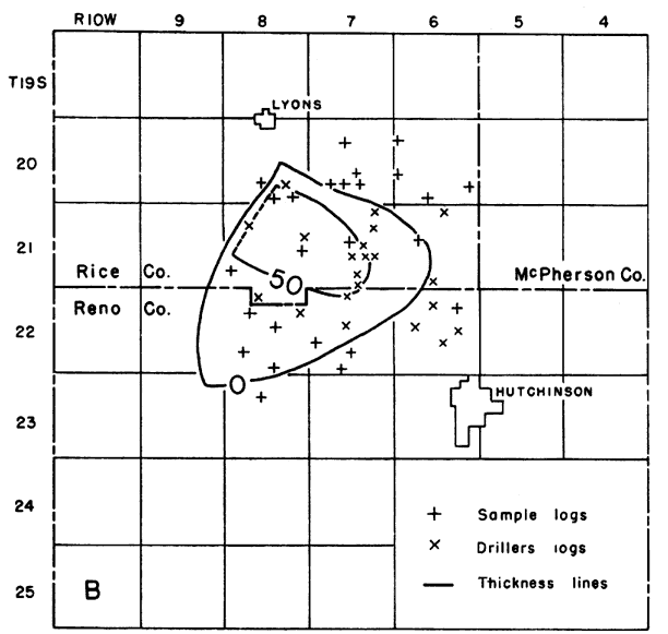
At the outcrops in southwestern Missouri and in the subsurface of the adjacent parts of southeastern Kansas, the Chattanooga ranges in thickness from a featheredge to 30 feet and consists of black fissile shale, slightly silty and finely micaceous with conspicuous amounts of pyrite. The shale contains plant spores which are especially abundant in the lower part. Toward the north and west (Lee, 1940, pp. 21-23; cross section B-B', Pl. 5) the shale thickens and becomes lighter in color. The basal beds, however, are nearly everywhere dark colored, if not black, and include abundant spores. In northeastern and north-central Kansas the color of the shales is generally gray or gray green but interstratified darker shales occur in some places above the base. With increasing thickness the Chattanooga becomes locally dolomitic in some zones and in some areas includes beds of impure dolomite. In the Appleman Oil Company No. 1 McManus well in sec. 29, T. 15 S., R. 6 W., a bed of finely sucrose silty dolomite 15 feet thick, lying 35 feet above the base of the shale, contains spores typical of the Chattanooga. Spores in the dolomitic beds of the Chattanooga have also been observed in other wells. In the Salina basin the shales are finely micaceous but less silty and more argillaceous than to the south and east. Gray earthy limestone has been observed locally in the middle part of the shale section in the Calikan Producing Company and I.T.I.O. No. 1A Fair well in sec. 4, T. 22 S., R. 8 W. in Harvey County and in another well in sec. 8 of the same township. This limestone is believed to be a lentil within the Chattanooga shale. It occurs 100 feet below the top of the Chattanooga and in an area in which the Chattanooga shale is exceptionally thick. Figure 3B shows the distribution of this lentil which wedges out to the northeast and south and is cut off on the west by post-Mississippian beveling.
Fig. 3B--Map showing the area in Rice and Reno Counties underlain by the earthy limestone lentil of the Chattanooga shale.
The Misener sand at the base of the Chattanooga shale is of erratic distribution. In the central part of the Salina basin, it is generally represented only by rounded sand grains disseminated in shale at the base of the Chattanooga. Where the Misener is a sandstone, it lies below the black spore-bearing shale, except in the Hollow pool in T. 22 S., R. 3 W. in Harvey County where cores from wells reveal a bed, 1 or more feet thick, of gray or black slate with large numbers of Lingula below the Misener sand.
The thickness of the Misener sand is greatest in wells in the deeper parts of the pre-Chattanooga valleys where the Chattanooga shale is thick and on the flanks of the Central Kansas uplift. The development of the sandstone facies, although by no means general, seems to bear a relation to the proximity of pre-Chattanooga outcrops of the St. Peter sandstone on the Central Kansas uplift and to pre-Chattanooga outcrops of the basal sandy beds of the Devonian.
In many wells in Marion, McPherson, Salina, and Harvey counties, the Misener forms a bed of sandstone rarely more than 2 feet thick but in some localities much thicker. In Rice County a number of wells have encountered the Misener sand with thicknesses of 10 to more than 35 feet. It is 11 feet thick in a well in sec. 24, T. 11 S., R. 7 W. in Lincoln County and 5 feet thick in a well in sec. 35, T. 8 S., R. 9 W. in Mitchell County.
In many wells north of Dickinson County and in some wells as far south as Marion County, red or pink beds lie above the Chattanooga shale. They are interpreted in part as remnants of a weathered zone developed during the exposure that preceded the deposition of the Boice shale and in part as weathered material reworked to form the basal deposits of the Boice shale.
The thickness of the Chattanooga ranges from a featheredge to at least 263 feet. The thickness displays considerable irregularity on account of the unconformity at the base of the Chattanooga and the several periods of exposure of its top during which the original thickness was reduced by erosion.
In eastern and southeastern Kansas, the thickness of the Chattanooga increases toward the north with great regularity. If local topographic relief of any magnitude had existed on either the underlying surface or at the top, the thickness of the Chattanooga would have reflected the irregularities of either surface. Inasmuch as local irregularities in thickness are negligible in these areas, both the top and bottom of the Chattanooga must have been surfaces of exceptional smoothness. In northeastern Kansas the Chattanooga shale overlies limestones and dolomites of Devonian age. Toward the south it transgresses upon a smoothly leveled surface and rests in succession on rocks ranging in age from Devonian to Early Ordovician.
In the Salina basin the pre-Chattanooga surface was dissected by a broad open valley with a topographic relief of more than 200 feet. In T. 23 S., R. 2 W., in Harvey County on a pre-Chattanooga high, the Chattanooga shale has a maximum thickness of 20 feet. From this area it thickens in all directions. In McPherson and Marion Counties in a distance of less than 25 miles the thickness increases to more than 200 feet and the shale successively overlies progressively older rocks from Devonian dolomite to Kimmswick dolomite. Farther north, the Chattanooga thins and overlaps onto the same formations in reverse order. The stratigraphic and structural relations indicate the development of a deep pre-Chattanooga valley whose approximate configuration is shown by the thickness map of the Chattanooga shale (Pl. 6) and by the areal map of the pre-Chattanooga surface (Pl. 5). Earlier investigations (Lee, 1940, pls. 3 and 4) seemed to indicate that this valley drained northeastward across the later beveled Nemaha anticline into southeastern Nebraska where the Chattanooga and Boice shales, together, are thickest. The thickening of the shales in that area, however, is not accompanied by a corresponding thinning of the underlying Devonian limestones as would be the case if a channel had been cut in that area. The configuration of the valley as revealed by the areal geology of Plate 5 makes it seem more likely that the valley drained westward or northwestward.
After the deposition of the Chattanooga shale, the surface was re-elevated and was probably subjected to minor warping. Considerable areas to the west were stripped of Chattanooga shale at this time, for outliers of Chattanooga shale are reported in the subsurface as far west as Ness County (Lee, 1940, p. 25). Pre-Boice erosion of the Chattanooga shale is revealed in northeastern Kansas by the relations of the Chattanooga and Boice shales. In Nemaha and Brown Counties, Kansas, where the combined thickness of the shales varies little, the Chattanooga is thin where the Boice is thick and increases in thickness where the Boice is thin. The range in the thickness of the Chattanooga shale from 120 to 258 feet is a measure, though imperfect, of the topographic relief of the pre-Boice surface.
With resubmergence of the eroded surface the higher areas of the Chattanooga surface were reduced by wave and tidal action. At the same time the eroded material of the weathered surface was washed into topographically low areas where the surface was aggraded by reworked Chattanooga shale. The shale thus formed in these low areas is the Boice shale.
The smooth horizontal contact of the Chattanooga shale with the Chouteau limestone and its correlatives throughout large areas in eastern Kansas, northern Missouri, and parts of Iowa gives the illusion of conformable relations between these formations. The following considerations lead to the conclusion that this interval is of greater importance than has hitherto been recognized. (1) The Boice shale in parts of the Forest City basin intervenes between the Chattanooga shale and the Chouteau. (2) In northeastern Missouri, the Louisiana limestone and the Hannibal shale intervene between the Chattanooga (Grassy Creek) and the Chouteau. (3) In Smith County, Kansas, where the Chouteau and the lower member of the Sedalia are missing, the upper member of the Sedalia overlaps from the Boice shale onto the Chattanooga shale and locally overlaps onto rocks of pre-Chattanooga age.
The Chattanooga must have been removed from parts of Smith, Osborne, and Jewell counties before the deposition of the upper Sedalia (Pl. 6), for in this area upper Sedalia rocks overlap from the Chattanooga onto rocks of pre-Chattanooga age. The exposure of this area seems to have begun prior to Boice deposition and extended through Chouteau and lower Sedalia time.
South of McPherson County, except for outliers of upper Sedalia and Gilmore City rocks, the Kinderhookian Series is absent. In this area the Chattanooga is generally overlain by the St. Joe limestone of the Osagian Series. In some areas on the western flank of the Nemaha anticline and the eastern flank of the Central Kansas uplift, the Reeds Spring and the Burlington limestones overlap from older Osagian rocks onto the Chattanooga shale (Fig. 5B).
There is, therefore, a hiatus between the Chattanooga shale and the Boice shale that in some areas extended to late Sedalia time and in others to early Osagian or even to Burlington time, during which the Chattanooga must have been exposed and presumably subjected to erosion. The elevation above sea level and the erosion, however, are believed to have been slight, for the thinning of the Chattanooga in the areas of overlap is not substantial.
The final unconformity affecting the thickness of the Chattanooga developed in post-Mississippian time when the Nemaha anticline was folded, and the Central Kansas uplift and the Ozarks were re-elevated. The erosion of these anticlinal areas removed the Mississippian limestones from their crests and beveled the Chattanooga and older rocks on their flanks, thus reducing the surface to what was essentially a peneplain. The Chattanooga shale cropped out on this surface in a belt encircling the area of older rocks (Pl. 8).
Outliers of Chattanooga shale, such as the one in T. 17 S., R. 8 W. in Ellsworth County (Pl. 6) which are overlain by Pennsylvania rocks were presumably isolated during post-Mississippian exposure.
In consequence of the complex relations described, the Chattanooga rests unconformably on rocks ranging from Devonian to Early Ordovician age and is overlain by the Boice shale, by Mississippian limestones from the Chouteau to the Burlington, and by rocks of Pennsylvanian age.
Boice Shale
The Boice shale is best known from wells in southeastern Nebraska where it was named by Reed (1946) for the No. 1 Boice well drilled with cable tools by the Pawnee Royalty Company in sec. 18, T. 1 N., R. 16 E., Richardson County, Nebraska, from which an excellent set of samples is preserved in the files of the Nebraska Geological Survey. The section of the Boice shale as reported by Reed from the above-named well is given in Table 4.
| Table 4--Section of Boice shale in the Pawnee Royalty Company No. 1 Boice cable tool well in sec. 18, T. 1 N.. R. 16 E., Richardson County, Nebraska (Reed, 1946). | Thickness, feet |
||||
|---|---|---|---|---|---|
| Mississippian System | |||||
| Kinderhookian Series | |||||
| Chouteau limestone and Sedalia dolomite | 69 | ||||
| Boice shale | 31 | ||||
| Siltstone and sandstone, medium dark gray to brownish, calcareous, in part pyritic | 2 feet | ||||
| Shale, dark greenish gray with some pyritic and carbonaceous zones; calcareous with black "Sporangites" in lower 10 feet; interbedded with gray dolomitic siltstone and silty argillaceous dolomite | 19 feet | ||||
| Hematite, in flattened discoidal oolites or concretions ranging from 0.2 mm to 1.5 mm in diameter, in part embedded in rouge-red shale | 10 feet | ||||
| Chattanooga shale | 204 | ||||
| Devonian dolomite | |||||
A section of rocks in Holt County, Missouri, here referred by the writer to the Boice shale, was reported by McQueen and Greene (1938, p. 176) and is given in Table 5. The rocks were designated by Mary Hundhausen of the Missouri Geological Survey as "Kinderhook undifferentiated."
| Table 5--Section of the Boice shale in the Forest City No. 1 Davis cored well in sec. 41 T. 59 N., R. 38 W., Holt County, Missouri. | Thickness, feet |
||
|---|---|---|---|
| Mississippian limestone and dolomite | 331 | ||
| Boice shale | 43 | ||
| Shale, gray to green; containing specks and streaks of carbonaceous material | 5 | ||
| Dolomite, gray, argillaceous | 4 | ||
| Shale, green and gray with plant remains | 24 | ||
| Limonite oolite; oolites are brown, flattened, and oblong | 4 | ||
| Shale, gray and red | 2 1/2 | ||
| Hematite oolite, flattened, discoidal oolites, cemented with calcium carbonate | 3 1/2 | ||
| Hematite, dark red, shaly | 6 | ||
| Mississippian or Devonian rocks | |||
| Chattanooga shale | 83 | ||
In Kansas in the Ohio Oil Company No. 1 Lamparter well in sec. 3, T. 2 S., R. 1.4 E., the thickness of shale above the base of the oolite is 90 feet and the Chattanooga is 135 feet thick. In sec. 15, T. 2 S., R. 16 E. the Boice shale is 11.0 feet thick and the Chattanooga is 125 feet thick. In sec. 11, T. 4 S., R. 14 E. the Boice shale is only 14 feet thick and the underlying Chattanooga is 258 feet thick. In scattered wells in Clay, Mitchell, Dickinson, and Saline counties the Boice shale, where present, is represented only by the oolitic member which is 5 to 25 feet thick. In these counties red shale without oolites, from 20 to 40 feet thick, which occurs in some wells at the top of the Chattanooga may be of Boice age but some of the zones of red shale, especially where they are mixed with green shale, may be weathered Chattanooga shale in place. Such a well occurs in Dickinson County in sec. 11, T. 13 S., R. 1 E. where red and green shales 10 feet thick underlie the oolitic member of the Boice.
Except where the Boice shale contains red and oolitic beds it is singularly like the Chattanooga shale from which the major part of the sediments for the Boice is believed to have been derived. In Nemaha and Brown counties, Kansas, where considerable thicknesses of green and gray shale overlie the red oolitic beds, the Boice shale is finely micaceous, resembles the upper part of the Chattanooga, and includes thinly disseminated spores. The Boice shale is more argillaceous and more dolomitic than the Chattanooga shale but the lithologic differences are not sufficiently striking to distinguish the formations in the absence of the oolitic zone.
The Boice shale so far as known is confined to southeastern Nebraska, southwestern Iowa, northwestern Missouri, and northeastern Kansas. In the Forest City basin in Kansas, the Boice thins sharply southward from central Brown and Nemaha counties. Red shale at the top of the Chattanooga probably in part of Boice age occurs in northeastern Wabaunsee County. In the Salina basin ferruginous oolites extend south to Saline and Dickinson counties and red shale without oolites to northeastern Marion County. Westward the oolitic bed extends to the border of the Central Kansas uplift where in sec. 35, T. 8 S., R. 9 W., 25 feet of ferruginous oolitic beds overlie the Chattanooga which is here represented only by 5 feet of the Misener sand.
The Boice shale is unconformable on the Chattanooga and seemingly conformable below the Chouteau in the area centering around the corners of Nebraska, Kansas, and Missouri. In the northern part of the Salina basin, the oolitic bed, where present, is unconformably overlain by the upper member of the Sedalia dolomite.
Rocks of Mississippian Age
Mississippian rocks are widely distributed in the Mississippi Valley both at the surface and in the subsurface. Some of the formations were deposited only in certain regions and the areal extent of others was reduced by erosion. As a result, the sequence of Mississippian formations is nowhere complete and formations are missing from the top, middle, or bottom of the columnar section in different localities. Some of the breaks in the formational sequence are true disconformities, but some were accompanied by obscure warping of so low an order that angular unconformity can be determined only by regional studies of the distribution and thickness of single formations and their relations to underlying and overlying units.
Limestones and dolomites predominate in the Mississippian rocks of the Middle West. The Mississippian of Kansas consists entirely of limestones and dolomites, except for the Northview shale, a local facies of the lower Sedalia dolomite in southeastern Kansas, and some shaly beds in the St. Joe of south-central Kansas. The Boice shale in the northeastern corner of Kansas may be of Mississippian age.
The Mississippian formations represented in the Salina basin are listed in Table 6 in descending order.
Table 6--Mississippian formations represented in the Salina basin.
| Meramecian Series | ||
| Spergen limestone | ||
| "Warsaw" limestone | ||
| Unconformity | ||
| Osagian Series | ||
| Burlington and Keokuk limestones, undifferentiated | ||
| Upper zone | ||
| Unconformity | ||
| Lower zone | ||
| Reeds Spring limestone | ||
| St. Joe limestone | ||
| Unconformity | ||
| Kinderhookian Series | ||
| Gilmore City limestone | ||
| Unconformity | ||
| Sedalia limestone (upper member only) | ||
| Unconformity | ||
| Rocks of Devonian or Mississippian age | ||
| Boice shale | ||
| Unconformity | ||
| Chattanooga shale | ||
Kinderhookian Series
The Chouteau limestone was first described by Swallow (1855) at Chouteau Springs in Cooper County, Missouri. The outcrops nearest to the Salina basin are in Pettis County in north-central Missouri. At the outcrops and in the subsurface of northeastern Kansas, three units of the Chouteau limestone, as originally defined, are distinguished by lithologic criteria: (1) a basal unit, relatively pure semigranular limestone, which is essentially equivalent to the Compton limestone of outcrops of southwestern Missouri; (2) a middle unit, an impure sucrose gray to buff dolomite having large amounts of uniquely characteristic chert; and (3) an upper unit, a noncherty or sparsely cherty buff sucrose dolomite. In Miami, Linn, and Anderson counties in eastern Kansas, the middle unit grades southward into and is at least a partial correlative of the Northview silty shale of southwestern Missouri and southeastern Kansas (Lee, 1940, p. 31).
In 1928 Moore separated the upper and middle units from the originally defined Chouteau and applied to them the name Sedalia limestone, and he thus restricted the Chouteau to the lower unit. The upper unit of the sequence in the subsurface for a time was considered as the Sedalia by the Missouri Geological Survey and this usage was followed by Lee in 1940.
In 1943 Lee (p. 67) described the Chouteau of Moore and the upper and lower members of the Sedalia limestone in the Forest City basin as three members of Swallow's original Chouteau. In the present report these terms are used to conform with the usage of the Kansas Geological Survey--namely, the application of Sedalia limestone to the upper and middle units of the original Chouteau and the restriction of Chouteau to the lower unit.
The Chouteau of Moore (1928) and both members of the Sedalia are well developed in the Forest City basin (Lee, 1943, p. 67), but only the upper member of the Sedalia has been recognized west of the Nemaha anticline.
Sedalia Dolomite
The upper member of the Sedalia consists of buff to brown, locally gray, sucrose dolomite. It is generally noncherty but in some wells small amounts (less than 5 percent) of chert similar to that in the lower member of the Sedalia have been noted in the insoluble residues. The upper member of the Sedalia extends westward to Smith County and southward across Saline County as shown in Figure 5. Thin outliers occur south of Saline County.
Fig. 4--Diagrammatic cross sections from southeastern Kansas to central Iowa showing structural relations of Kinderhookian to younger Mississippian limestones. Cross section A shows the attitude of the Kinderhookian rocks on the line X-X' at the beginning of Osagian time. Central Iowa had been a subsiding basin in which sediments of Kinderhookian rocks accumulated more thickly than in southeastern Kansas. Slight elevation and beveling probably ended Kinderhookian deposition. Cross section B shows the attitude of Mississippian formations at the end of Meramecian time on the same line. The surface of the beveled Kinderhookian rocks was progressively lowered toward the south during Osagian and Meramecian time. All the formations from St. Joe to St. Louis overlapped in turn, northward upon the surface of the Kinderhookian rocks. A larger version of this figure is available.
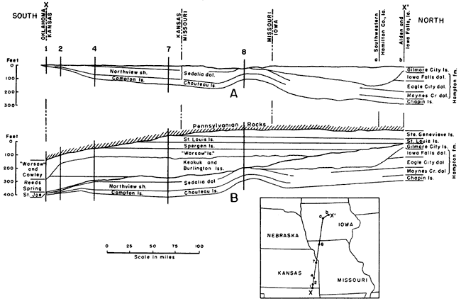
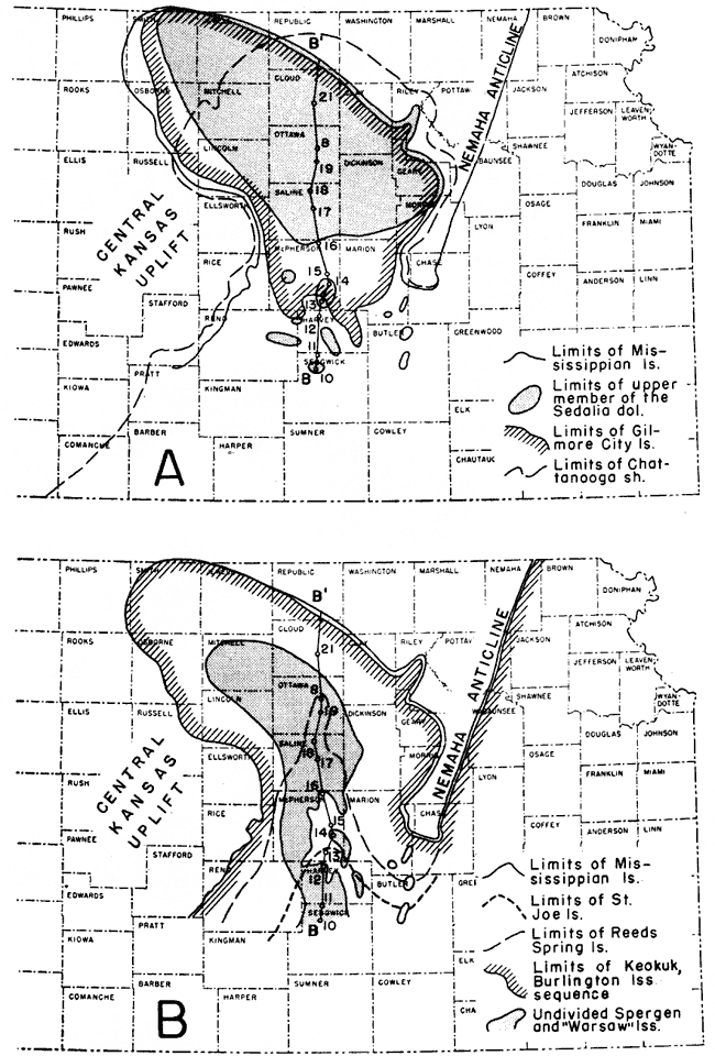
Fig. 5--Maps showing the approximate distribution of the Mississippian formations in the Salina basin area. A, the distribution of the Chattanooga shale and those Kinderhookian rocks that are represented in the Salina basin. The Kinderhookian rocks, originally more widely distributed, have been eroded from the southern part of the area. B, the approximate distribution of Osagian and Meramecian formations. The Osagian formations overlapped in turn upon the Kinderhookian surface. The distribution of the St. Joe and Reeds Spring limestones reveals the development of synclinal movements west of the Nemaha anticline in early Mississippian time. The distribution of the "Warsaw" and Spergen limestones, once general throughout the region, was restricted to synclinal areas by beveling at the close of Mississippian time.
Unconformities occur above and below the upper member in the Salina basin but its thickness reveals that both its upper and lower surfaces were exceptionally smooth and regular. The upper member thins westward with extraordinary regularity from Johnson County, Kansas, where it is 30 feet thick and overlies the lower member of the Sedalia, to Smith County, 200 miles west where it is less than 10 feet thick and overlies pre-Chattanooga rocks. In the Salina basin it is rarely more than 15 feet thick and in some of the outliers in McPherson and Harvey counties it is represented by less than 5 feet of buff sucrose dolomite.
The upper member of the Sedalia seems to be conformable upon the lower member in the Forest City basin. In the Salina basin, however, it overlaps unconformably onto the Chattanooga shale or the Boice shale where that formation is present, and wedges out to the west on the Devonian.
In the Salina basin the upper member of the Sedalia is overlain disconformably nearly everywhere by the Gilmore City limestone. The disconformity is obscure but it is revealed in a number of wells in the Forest City basin in which the Gilmore City rests on the lower member of the Sedalia (Lee, 1943, p. 69) and in cross section A of Figure 4. In McPherson and Marion Counties the Gilmore City rests on the Chattanooga shale. In these counties some of the thin outliers of upper Sedalia dolomite are overlain by the St. Joe limestone and locally in Reno County the Reeds Spring limestone overlaps onto the upper Sedalia (Fig. 5).
Gilmore City Limestone
The Gilmore City was first described by Laudon (1933) at outcrops in the vicinity of Gilmore City in central Iowa. At the outcrops, the Gilmore City is a pure white to gray oolitic limestone. Laudon reports that it is "usually bedded with green shale" and that minor amounts of blue dolomite occur at definite horizons. The Gilmore City limestone, the subsurface distribution of which in the Salina basin is shown in Figure 5, is similar to that of the outcrops but it is not oolitic throughout and is not dolomitic. It is 62 feet thick in the Seidhoff et al. No. 1 Greif well in sec. 16, T. 8 S., R. 10 W., but may be thicker toward the north. The thickness decreases somewhat irregularly toward the southeast where it wedges out in southern McPherson County and parts of Harvey County.
The Gilmore City in the Salina basin is a relatively pure noncherty or very slightly cherty granular limestone composed of worn fragments of finely broken fossils, with or without oolites, imbedded in a cryptocrystalline matrix. The matrix is firm in samples from some 2-ones but so chalky in others that except for the fossiliferous granules the cuttings from cable tool wells are generally reduced to calcareous mud and lost in washing. The color of the oolitic limestone is generally gray or white but shades of dark gray, yellowish brown, and buff are not uncommon, and in one well the color is pink. Fragments of green argillaceous shale are minor constituents of some samples.
The most outstanding characteristic of the Gilmore City limestone is the oolitic limestone. The oolites are irregularly distributed vertically and the oolitic beds are discontinuous horizontally. Oolites are commonly encountered 25 to 35 feet above the base of the Gilmore City, but oolitic beds occur erratically higher and lower in the formation. The oolites are variable in size and some of them are irregular in shape. They are commonly gray in color but some are dark to nearly black. Some of the oolites have black centers and some have alternating light and dark crusts. The oolites generally have the same color as the matrix.
The insoluble residues of the Gilmore City are so small in amount as to be almost negligible. Chert particles derived from younger rocks in the wells occur in the insoluble residues of some samples but there are traces of indigenous vitreous chert. The characteristic residues consist of loose aggregates of very fine quartz crystals, thin finely drusy crusts and microscopic mammilary and columnar flakes of chalcedony. Traces of spherical crusts from partly silicified oolites are occasionally found. In Saline County and to the north the residues are generally pale lemon yellow but elsewhere they are colorless.
Where the Gilmore City is thin and nonoolitic it is distinguished from the St. Joe by the dark color and argillaceous character of the St. Joe. Although the lower part of the Reeds Spring in some areas is a semigranular limestone not unlike the Gilmore City, the Reeds Spring contains translucent chert which is absent in the Gilmore City.
At places along its southern margin, the Gilmore City rests unconformably on the Chattanooga shale or on outliers of the upper member of the Sedalia dolomite. The Gilmore City is separated by a pronounced unconformity from the overlying Osagian rocks. In a few wells in Harvey County as in the McBride Inc. No. 1 Friesen well in sec. 20, T. 22 S., R. 3 W. in northwestern Harvey County, a thin bed of nonoolitic Gilmore City limestone is overlain by dull dark earthy St. Joe limestone, which elsewhere overlies the upper member of the Sedalia or the Chattanooga shale. Farther north, the Gilmore City is overlain by the Reeds Spring dolomite and still farther north by the lower zone of the Burlington-Keokuk limestone sequence (Fig. 5).
Osagian Series
Osagian rocks are widely distributed in the Mississippi Valley and are represented in the subsurface in the Salina basin. As originally used by Williams (1891), the term Osage included only the Burlington and Keokuk limestones of southeastern Iowa. The term was later expanded to include the underlying Fern Glen limestone of eastern Missouri. Some geologists include the overlying Warsaw limestone in the Osagian, but on account of the pronounced unconformity at the base of the southern Kansas "Warsaw," the writers place it in the Meramecian.
The Fern Glen is represented in southwestern Missouri by the Reeds Spring limestone above and the St. Joe limestone below, both of which change their lithologic character in the subsurface toward the west. In outcrops in southwestern Missouri and in the subsurface of southeastern Kansas, the St. Joe limestone consists of noncherty or very sparsely cherty semigranular fossiliferous limestone. Toward the west in southern Kansas the St. Joe thickens and some zones become argillaceous. In the area south of the Salina basin it includes beds of calcareous green and red shale and some reddish granular limestone.
At outcrops in southwestern Missouri, the Reeds Spring consists of dolomite interbedded with vitreous dark to almost black chert, opaque in hand specimens but semitranslucent in small chips. In the subsurface of southeastern Kansas, the chert cuttings from wells are dark to brownish and semitranslucent. Farther west in southern Kansas, the dolomite changes gradually to semigranular limestone with variable amounts of semitranslucent to translucent bluish, gray, and colorless chalcedonic chert.
The correlatives of both the St. Joe and Reeds Spring thin and wedge out toward the north both east and west of the Nemaha anticline. Neither is present on the crest of the anticline (Fig. 5). The Reeds Spring limestone overlaps northward beyond the margin of the St. Joe and in turn it is overlapped by the more widely distributed Burlington.
St. Joe Limestone
In the area immediately south of the Salina basin in Sedgwick County, the St. Joe limestone consists of alternating beds of noncherty semigranular limestone, argillaceous limestone, and calcareous shale, from 75 to 100 feet thick. Toward the north this sequence of beds becomes thinner and. more argillaceous and on the border of Harvey County consists of dark argillaceous limestone, in part earthy textured and in part dark, impure, dull, and finely crystalline. In Harvey County, the St. Joe ranges in thickness from 10 to 40 feet. It thins out irregularly northward in the basin between the Central Kansas uplift and the Nemaha anticline as shown on Figure 6. The variable thickness is due largely to the unconformity at its base. The separation of the St. Joe from the Reeds Spring in most parts of southeastern Kansas is based on the absence of chert in the St. Joe cuttings and their presence in the Reeds Spring cuttings. Consequently, the separation is arbitrary and the selected contact somewhat variable in position. In Harvey County, the argillaceous character and the dark color of the St. Joe provide additional criteria for their differentiation.
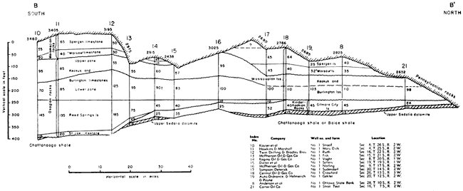
Fig. 6--Stratigraphic cross section from south to north on the line B-B' of Figure 5 and Plate 8 showing overlap of Osagian rocks on the Kinderhookian surface. Figures at left of wells at top show depth in feet below the surface. Figures at right of wells show thickness of lithologic units. The wells are correlated on the base of the Burlington. The upper member of the Sedalia dolomite was eroded from parts of the area but outliers occur toward the south. The St. Joe, Reeds Spring, and Burlington in conformable sequence overlap in turn upon the surface of the Kinderhookian. Unconformities occur at the base of the upper member of the Sedalia, Gilmore City, Keokuk, and "Warsaw." A larger version of this figure is available.
In Reno and Harvey counties, the St. Joe is in contact in different localities with the underlying Gilmore City, the upper member of the Sedalia, or the Chattanooga shale with all of which it is unconformable. Thus, in the McBride No. 1 Friesen well in sec. 20, T. 22 S., R. 3 W., 5 feet of dark dense St. Joe limestone overlies 25 feet of Gilmore City; in the Boyle Grossman Drilling Company No. 1. Moulds well in sec. 7,, T. 24 S., R. 1 W., 25 feet of St. Joe limestone overlies 5 feet of upper Sedalia dolomite; in the Garland et al. No. 1 Cox well, in sec. 27, T. 24 S., R. 1 W., 30 feet of St. Joe immediately overlies Chattanooga shale. The St. Joe limestone seems to be conformable below the Reeds Spring limestone, although in Harvey County a marked lithologic break at the top of the dark earthy limestone of the St. Joe marks the contact with the Reeds Spring. The contact between the two limestones is transitional in southeastern Kansas.
Reeds Spring Limestone
In the part of Kansas south of the Salina basin, the Reeds Spring limestone of late Fern Glen age is composed mainly of semigranular limestone, but it includes some interbedded dolomite and some slightly argillaceous limestone. Conspicuous amounts of chert occur throughout most of the formation; at some places zones near the base are only sparsely cherty. The distinguishing feature of the Reeds Spring is the translucent and semitranslucent character of the chert. The color of the chert is variable. Shades of blue and bluish gray predominate. Some zones are yellowish and some are dark and brown, like the chert in the outcrops of southwestern Missouri and northeastern Oklahoma. Some of the chert is colorless in thin chips. In drill cuttings the chert is generally represented by smooth splinters and blocky fragments with sharp flinty edges. In some zones minor amounts of opaque blocky chert with rough surfaces occur with the semitranslucent chert. The contact of the Reeds Spring with the Burlington is determined by the change from the dominantly semitranslucent splintery chert of the Reeds Spring to the dominantly opaque and semiopaque blocky chert of the Burlington.
The distribution of the Reeds Spring in the Salina basin is shown in Figure 5. In this basin the Reeds Spring overlaps the St. Joe limestone and thins to a wedge toward the north, east, and west. It is thickest on the southern margin of the mapped area (Fig. 5) in northern Sedgwick County and southern Harvey County where it is 100 to 120 feet thick. In the area where it overlaps beyond the St. Joe limestone its thickness is materially reduced. In central McPherson County its thickness ranges from 30 to 60 feet, but in central Saline County its thickness rarely exceeds 20 feet (Fig. 6).
The Reeds Spring is conformable above the St. Joe limestone,, but in the absence of the St. Joe it is unconformable on the older rocks upon which it overlaps. It overlies the Chattanooga shale in parts of Reno County and in much of Butler County. It overlies thin outliers of the upper member of the Sedalia at a few places in Reno County but toward the north, in the absence of the St. Joe, the Reeds Spring overlaps onto the Gilmore City.
The contact of the Reeds Spring with the overlying lower zone of the Burlington-Keokuk sequence is transitional. The lack of a clear-cut lithologic contact between them and the eroded surface at the base of the Reeds Spring in areas where it overlaps beyond the St. Joe account for some of the irregularities in its thickness.
Burlington and Keokuk Limestones
Burlington and Keokuk limestones are widely distributed in the Mississippi Valley both at the surface and in the subsurface but without the aid of fossils their differentiation in the subsurface of the Salina basin is unsatisfactory. Moore (1928, pp. 143, 207) and Moore, Fowler, and Lyden (1939, p. 9) report a hiatus between the Burlington and the Keokuk in outcrops in southwestern Missouri. In the Joplin district Moore found the Burlington limestone absent and the Keokuk lying disconformably on the Reeds Spring limestone. Laudon (1939, p. 329) reports the same relations throughout northeastern Oklahoma. Lee (1940, p. 58) has described lithologic differences in the subsurface of Kansas between the lower and upper zones of the Burlington-Keokuk sequence and has tentatively correlated them, respectively, with the Burlington limestone and the Keokuk limestone. The variable position of the contact between the two zones supports the conclusion that the upper zone lies unconformably on the lower. Where the Burlington is absent in the Joplin area, only rocks of the upper zone are present. In other areas both lithologic phases occur with erratic variations in thickness. The lower zone, which is transitional with the underlying Reeds Spring, is at least partly of Burlington age and the upper zone at least partly of Keokuk age. Both zones consist of cherty limestones and dolomites but are differentiated by the character of the chert.
Lower zone--The lower zone is characterized by opaque chert of microscopically massive texture, which appears in well cuttings as blocky fragments with more or less tabular surfaces. The sequence of beds characterized by typical white opaque chert is interrupted in some wells by zones rarely more than 5 feet thick with semitranslucent chert of the Reeds Spring type. A minor amount of rough nondescript chert is present in many samples. Some chert, commonly associated with sucrose dolomite or dolomitic limestones, shows a grainy or stippled pattern on the smoothly broken surface. Some of the chert breaks with rough and pitted surfaces. Traces of sparsely distributed microorganisms and spicules appear on the broken faces of some chert fragments in the upper part of the lower zone. Insoluble residues of samples from the lower zone reveal quartz crystals, drusy quartz, and hackly quartz. Insoluble residues from some dolomitic beds include dolomoldic chert.
The lower zone varies in thickness from place to place by reason of its unconformable relations to the upper zone and its locally obscure contact with the Reeds Spring. It is thickest in Harvey County where several wells found it to be more than 150 feet thick. It is 155 feet thick in the Rosenthal and Madison No. 1 Masters well in sec. 24, T. 23 S., R. 3 W. but toward the north it is commonly 75 to 120 feet thick although locally it is thinner. In areas where it overlaps beyond the Reeds Spring its thickness although variable is commonly less than 50 feet.
Upper zone--Most of the chert of the upper zone is white, rough, and pitted, and breaks into subangular fragments. Although other types of chert occur in the upper part of the zone they are uncommon in the lower part. Microfossiliferous chert, similar to that in the "Warsaw," occurs in some areas in the middle or upper part of the upper zone, but it is distinguished from "Warsaw" chert by the replacement of the microorganisms with glassy or translucent chalcedony. The cherts of the upper zone include varying amounts of siliceous aggregates resembling tripoli which are sometimes referred to as "cotton rock." Some of the "cotton rock" is firm but some is soft. The greater part of the limestone and dolomite of the lower zone is siliceous and, when treated with acid leaves soft tripolitic crumbs of "cotton rock" which constitute a considerable proportion of the volume of the insoluble residues. Insoluble residues of dolomitic beds leave also dolomoldic chert. The contact between limestones with blocky opaque gray chert of the lower zone and limestones with subangular, rough, pitted, and tripolitic white chert of the upper zone is generally sharply marked.
In southeastern Kansas, where the Burlington limestone is absent, an oolitic bed (probably the Short Creek oolite), occurs high above the base of the Keokuk limestone. On the southern margin of the Salina basin, where the upper zone of the Keokuk-Burlington sequence is underlain by the lower zone, the oolitic bed lies at or near the base of the upper zone. The oolitic bed was not observed in the more northerly wells in the Salina basin.
The upper zone, which is bounded both above and below by disconformities, varies greatly in thickness. In Harvey County and northern Butler County, it has a local thickness of as much as 110 feet although thicknesses of 70 to 80 feet are more common. It is less than 70 feet thick in most areas north of Harvey County and is absent in some wells on the margin of the Salina basin where it was removed by pre-Pennsylvanian erosion. In general, the upper zone, like the lower zone, is thinner toward the north than toward the south, and their combined thickness where they are overlain by the "Warsaw" is also less.
The upper zone is separated by unconformity from the overlying Meramecian formations. In the Salina basin the upper surface of the upper zone was one of moderate relief, but farther south near the Oklahoma border the Keokuk and older rocks were eroded.
Meramecian Series
Rocks of Meramecian age are present in widely separated areas in the Mississippi Valley. In Kansas they consist in descending order of the Ste. Genevieve, St. Louis, Spergen, and "Warsaw" limestones and the Cowley formation. [Note: Rocks called Warsaw by Lee in the manuscript of this report are judged to be wholly younger than the type Warsaw, which carries a characteristic Osagian fauna and, as confirmed by recent field studies of Laudon, must be classed as upper Osagian--not lower Meramecian. Accordingly, Lee's Warsaw has been changed editorially to "Warsaw."--R. C. Moore] The sequence from the "Warsaw" limestone to the Ste. Genevieve limestone occurs in the subsurface of the deeper parts of the Forest City basin and on the southwestern flank of the Central Kansas uplift in western Kansas. The "Warsaw" and Spergen limestones are preserved in the central part of the Salina basin and in other synclinal areas. All the formations of Meramecian age except the Cowley were probably deposited throughout Kansas but were removed from anticlinal areas by the erosion which followed the post-Mississippian deformation.
Meramecian time was preceded by an elevation of Kansas above sea level and the Keokuk and earlier Mississippian rocks were deeply eroded in southern Kansas, where in some valley areas erosion cut through the Chattanooga shale and exposed pre-Chattanooga rocks. The relations of the early Meramecian deposits to the Keokuk in the Salina basin reveal a dissected surface at their base, although the relief is less pronounced than in southern Kansas. The first deposit of. Meramecian age in southern Kansas during the resubmergence of the region was the Cowley formation (Lee, 1940, pp. 66-78). On the northern margin of the erosional basin this formation consists of silty and dolomitic gray and black shale in areas near the shore line but basinward in southern Kansas and northern Oklahoma it becomes less argillaceous and more dolomitic. The Cowley is commonly very cherty, although the chert content varies greatly in different areas. The chert is characterized by crowded masses of microorganisms but this characteristic is less well developed in northern Oklahoma. As the advancing sea spread out over the less deeply eroded surface of the upland toward the north, the argillaceous and silty sediments graded upward into the semigranular limestone of the "Warsaw." The "Warsaw" limestone generally contains much chert. The Spergen limestone overlies the "Warsaw" with seeming conformity in eastern Kansas. It is interstratified with sucrose dolomite. In some places in northeastern Kansas where the Spergen consists largely of dolomite it is locally interstratified with granular limestone lentils. Patient examination of these granular limestones generally reveals the presence of thinly disseminated specimens of the foraminifer Endothyra. Insoluble residue of the dolomitic beds reveal much silt and spongy masses of spicules. The St. Louis limestone overlies the Spergen in northeastern and southwestern Kansas. The St. Louis limestone includes some granular limestone and is locally oolitic but its distinctive characteristic is lithographic limestone. If it is separated from the Spergen by disconformity, the contact is a surface of low relief. The Ste. Genevieve limestone in northeastern Kansas includes noncherty oolitic beds and noncherty granular limestone. The basal limestone beds enclose disseminated coarse silt and fine angular sand. It is oolitic in western Kansas.
"Warsaw" Limestone
The "Warsaw" limestone in the Salina basin consists mainly of semigranular cherty limestone, although some sucrose dolomite occurs as the matrix cementing crystalline fragments of broken fossils. The chert is variable in amount and rarely reaches 40 percent of the volume of samples. It is typically lighter colored than the chert of the Cowley formation and although the silicified organic remains are revealed in dark patterns against a gray matrix in some fragments much of the microfossiliferous chert is entirely gray and the microfossiliferous character is less noticeable. The silicified fossils of the "Warsaw" chert are commonly coarser than those in the Cowley.
The maximum observed thickness of the "Warsaw" is in the Kinney-Coastal Oil Company No. 1 Beil well in sec. 23, T. 14 S., R. 5 W. where it is 80 feet thick. This thickness is exceptional. The "Warsaw" is commonly less than 50 feet thick and it wedges out locally on the flanks of topographically high areas of the pre-"Warsaw" surface as shown between wells 16 and 17 of Figure 6. The great variations in thickness are due to the unconformities at the top and bottom. The oldest beds of the "Warsaw" seem to have been deposited in deeply eroded areas of the Keokuk surface, and the later beds of the "Warsaw" seem to have been deposited on higher parts of this surface. Some wells, in which the "Warsaw" is missing, reveal Spergen limestone directly overlying the Keokuk.
The "Warsaw" limestone and the overlying Spergen limestone survived post-Mississippian erosion only in the deeper parts of the Salina basin. They are present in the syncline between the Voshell anticline and the Central Kansas uplift, in synclinal areas east and west of the Halstead and Graber pools, and in the structural basin west of the Valley Center anticline (Fig. 5). On the flanks of these synclines, the "Warsaw" was beveled by pre-Pennsylvanian erosion and covered by Pennsylvanian rocks.
Spergen Limestone
The Spergen limestone is less widely distributed than the "Warsaw" in the structural basins and synclinal areas of the Salina basin. It is composed mainly of noncherty yellowish granular limestone with a slightly waxy luster. In some localities the limestone is interstratified in the upper part with noncherty sucrose dolomite. The basal member, however, is generally dolomitic and silty. In wells in Ts. 20 and 21 S., R. 4 W., the basal dolomite is 15 to 20 feet thick and includes exceptionally large amounts of semitranslucent chalcedonic chert which in this area amounts to 10 to 20 percent of the samples. This dolomitic member is of variable thickness and is less silty and less cherty farther north.
The Spergen is less than 40 feet thick in most wells in which has been encountered. However, in the Auto-Ordnance-Darby No. 1 Gawith well in sec. 27, T. 11 S., R. 5 W.. a thickness of 99 feet was drilled (well 5, cross section A-A, Pl. 8). In the absence of lithographic limestone by which the St. Louis limestone is commonly recognized the entire thickness of this unusually thick limestone is referred somewhat doubtfully to the Spergen.
The Spergen normally succeeds the "Warsaw" but where the "Warsaw" is absent it may overlap onto the Keokuk. In the Salina basin surviving remnants of the Spergen are everywhere unconformable beneath rocks of Pennsylvanian age.
Prev Page--Stratigraphy, Pre-Cambrian to Ordovician || Next Page--Stratigraphy, Pennsylvanian
Kansas Geological Survey, Geology
Placed on web Dec. 28, 2007; originally published Nov. 1948.
Comments to webadmin@kgs.ku.edu
The URL for this page is http://www.kgs.ku.edu/Publications/Bulletins/74/03_strat2.html