![]()
Prev Page--Uses || Next Page--References
Occurrence by Counties
The following paragraphs present a description of the larger areas of calcite- and dolomite-cemented sandstone and silica-cemented sandstone in the Dakota and Kiowa formations of Kansas. Areas of large numbers of calcite-cemented sandstone concretions are discussed, but are not considered to be of economic importance. Ferruginous sandstone is not included in this section, except in a few instances where quarries have been noted. No core data were available, and estimates of the available tonnage are omitted because of the erratic pattern of cementation and because natural outcrops of the calcareous sandstone do not permit accurate estimation of its thickness. Special note is made of any areas of calcareous sandstone which may prove to be of economic value.
Clay County
Two large concretionary bodies of calcite-cemented sandstone near the Clay-Cloud County line 1 1/2 miles west of Oak Hill are reported by the County Engineer to have been used on State Highway 9. No other large quantities of calcareous sandstone were observed in the county. There are several small county quarries in ferruginous sandstone: in the west side of sec. 25, T. 8 S., R. 1 E., 2 miles south of Idana, a bed of dark-brown sandstone 8 to 10 feet thick capping a prominent hill has been quarried for road material. Some of the hardest ferruginous sandstone in the county occurs in a large hill along the west line of sec. 3, T. 6 S., R. 2 E., 6 to 7 miles north of Morganville. There is a small quarry at the south end of the hill.
Small isolated calcareous sandstone concretions are observed in various parts of the county, as, for example, in a road cut in the NE cor. sec. 17, T. 10 S., R. 1 E., 1 mile north of Longford, and at the SW cor. sec. 7, T. 9 S., R. 1 E., near the Cloud County line. Thin beds of calcite-cemented sandstone occur in the SW cor. sec. 22, T. 9 S., R. 1 E., 1 1/2 miles east of Oak Hill, and in the N2 NE 1/4 sec. 17, T. 9 S., R. 1 E., 2 miles north of Oak Hill.
Dickinson County
Extensive ledges of calcite-cemented sandstone, some of which contains barite sand-crystals, have been reported in the "Black Hills" southwest of Elmo. Two small areas of calcite-cemented sandstone were observed in the NW sec. 35, T. 16 S., R. 1E., but the sandstone is of poor quality because of the presence of iron, and the deposits are not large enough for exploitation.
Ellsworth County
Large quantities of calcite-cemented sandstone have been quarried in the SE sec. 19, T. 16 S., R. 6 W., for use in the construction of the Kanopolis dam. This quarry is in an extensive area of calcareous sandstone which extends to the west and northwest, and crops out in at least five sections south of the Smoky Hill River, where it attains a thickness of several feet near a group of farm buildings in the NW sec. 30, T. 16 S., R. 6 W. In the N2 sec. 18 of the same township the rock is exposed on both sides of the Smoky Hill River; on the north side of the river it is at least 50 feet thick. In the summer of 1947 a new quarry was opened in this area, in the NE sec. 24, T. 16 S., R. 7 W., where a maximum thickness of about 40 feet was reported from test drilling (personal communication from Stafford C. Happ to John C. Frye).
In the original Kanopolis quarry, at which site there were probably at least 250,000 tons available, the hard sandstone crops out on both sides of a small ravine. At the time the quarry was examined, the calcareous sandstone seemed to occur at two levels, a fairly continuous lower one, attaining a thickness of more than 8 feet, and an upper zone consisting of large concretionary bodies 10 to 12 feet in diameter and 3 or more feet thick. Much of the lower quartzite contains pyrite. Between the two is a bed 6 inches to 3 feet thick of clay or shale containing cone-in-cone.
A discontinuous bed of calcite-cemented sandstone about 5 feet thick may be traced for several hundred feet in sec. 33, T. 15 S., R. 7 W., about 2 1/2 miles east of Kanopolis, on the east side of the Smoky Hill River (Twenhofel and Tester, 1926). The total quantity present is not known. Calcite-cemented sandstone concretions, occurring alone and in small groups, are common in the Dakota in the eastern part of Ellsworth County. They may be observed at several places near Highway U.S. 40 between Carneiro and the Saline County line.
Kearny County
A hard, 3- to 5-foot ledge of silica-cemented sandstone extends for nearly a mile in sec. 17, T. 25 S., R. 37 W., on the south side of the Arkansas River 2 miles west of Hartland. The overburden is only a few feet thick, and consists of unconsolidated sand and gravel. J.M. Jewett (personal communication) reports that a test hole shows the presence of the same thickness of quartzite for several yards at least, back under the sand and gravel. Small amounts of opal may occur in some parts of this rock, as in other areas of quartzite in the Dakota and Kiowa formations. No other outcrops of the Dakota formation are known to occur in Kearny County (McLaughlin, 1943).
Lincoln County
Although calcareous sandstone has been quarried in Lincoln County since 1921, the largest reserves are still thought to occur in this area. The rock was first quarried 1 mile southeast of Lincoln by the Lincoln Crushed Stone Company of Concordia. In 1924 the Lincoln quarry was sold into new hands but retained the old name; in 1931 in was sold to J.R. Carlgren and called thereafter the Quartzite Stone Company. The rock has been quarried from a solid ledge of hard sandstone, 500 feet long and from 15 to 40 feet thick, but the location is now abandoned. Mr. Carlgren (personal communication) reports that probably 2 million tons have been removed since 1921; since 1931 at the rate of 100,000 tons per year. Large reserves of calcareous sandstone occur southwest of Lincoln in a lentil or series of lentils in secs. 12, 13, 14, 23, and 24, T. 12 S., R. 8 W. In parts of secs. 12 and 13 it attains a thickness of more than 30 feet.
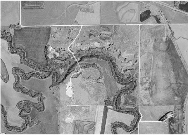
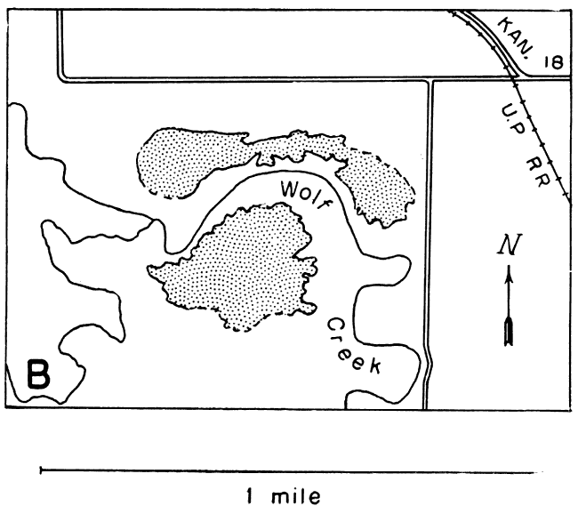
Dolomite-cemented sandstone is quarried by the Quartzite Stone Company at a new location in the NE sec. 7, T. 12 S., R. 10 W., near State Highway 18, 5 miles west of Sylvan Grove (Pl. 1A). In this area a large lentil of hard sandstone one-half mile in diameter and up to 50 feet or more thick is traversed by Wolf Creek, a tributary to the Saline River (Pl. 7). The total quantity of rock here is estimated at more than 5 million tons.
Small quantities of calcite-cemented sandstone occur in other parts of the county, as, for example, along East Elkhorn Creek in the W2 sec. 10, T. 13 S., R. 7 W., and in the SE sec. 1, T. 11 S., R. 6 W.
Plate 7--A, Aerial photograph of lentil of dolomite-cemented sandstone in sec. 7, T. 12 S., R. 10 W., Lincoln County. Site of Sylvan Grove quarry. [Aerial photo taken 2002, courtesy of Kansas Data Access and Support Center.] B, Sketch map of same area, showing outlines of the lentil, roads, railroad, and drainage.
McPherson County
Two large areas of calcite-cemented sandstone occur in McPherson County. One is 3 miles west of Roxbury; the other is a long series of lentils trending south from sec. 2, T. 18 S., R. 2 W., to sec. 6, a distance of about 4 or 5 miles. The deposit west of Roxbury crops out in a long hill or ridge in the NE sec. 25, and the E2 sec. 24, T. 17 S., R. 2 W. (Pl. 4C). The southern part of the ridge is capped with thin silica- and iron-cemented sandstone. The rock, which ranges in thickness from a featheredge to 15 feel or more, locally contains barite sand-crystals and has been quarried by the W.P.A. in the NE sec. 25. Mr. H.F. Gonnerman, Director of Research, Portland Cement Association, reports (personal communication) that small quantities of barite (less than 2 percent) when present in a calcareous sandstone used for aggregate are not believed to have any deleterious effect on concrete.
There are at least two abandoned quarries in the other large area of calcite-cemented sandstone. The county has removed several tons of rock for road material from a quarry (Pl. 2C) in the NE sec. 14, T. 18 S., R. 2 W., east of the North Diamond district school. A small worked-out quarry is located along the south line of the SW sec. 23. The total quantity of sandstone available in the area is judged to be more than 1 million tons.
Small quantities of silica-cemented sandstone cap Twin Mounds (NW sec. 1, T. 18 S., R. 2 W.) and form a low hill in the west side of sec. 15, T. 18 S., R. I W., 4 1/2 miles south of Roxbury. In the latter vicinity, three similar hills of quartzite have been removed. Isolated concretions of dolomite-cemented sandstone are observed near the base of the northern Twin Mound, and in the south side of the SE sec. 19, T. 17 S., R. 2 W., 8 miles west of Roxbury.
Ottawa County
The only locality known to me in which calcareous sandstone occurs in quantities large enough to be quarried is in the SE sec. 20, T. 9 S., R. 2 W. The deposit is small, and some of it has been removed for road material.
Rice County
A lenticular area of calcite-cemented sandstone extends from the SE SW sec. 20, T. 20 S., R. 6 W. along the top of a hill northeastward to the SW NW sec. 15, T. 20 S., R. 6 W. The rock is poorly exposed, but its thickness in some places is observed to be at least 10 feet, and may be much more.
Another area of calcite-cemented sandstone of considerable extent occurs near Raymond in the southwestern part of the county. The sandstone crops out along the valley side of the Arkansas River from the SW SE sec. 21, T. 20 S., R. 10 W. to the SW SE sec. 26. Its thickness is about 5 feet, and it has been quarried to a small extent.
Saline County
A large quarry in a hillside in thick, calcite-cemented sandstone is located in the NW sec. 36, T. 14 S., R. 4 W., 2 miles east of Bavaria. This quarry was first leased by a private contractor, then by the Army for Camp Phillips. It was recently leased by another private contractor. The quartzite is fine- to medium-grained with numerous sand-barite nodules, and several hundred thousand tons seems to be available. No other large quantities have been observed in the county.
Prev Page--Uses || Next Page--References
Kansas Geological Survey, Geology
Placed on web June 14, 2007; originally published Nov. 1947.
Comments to webadmin@kgs.ku.edu
The URL for this page is http://www.kgs.ku.edu/Publications/Bulletins/70_4/08_occu.html