![]()
Prev Page--Uses || Next Page--References
Occurrence in Kansas by Counties
The following paragraphs present a description. by counties, of all localities examined in the field. Estimates of the available tonnage have been obtained solely from surface observations, no core hole data being available. Rock believed to be overlain by a thickness of overburden sufficient to preclude commercial development has not been included in the tonnage estimates. Although the quantities reported are conservative in most cases, the lenticular nature of the deposits may have led to excessively high or low estimates for a few localities. The field inventory of the quartzite was extensive, but it is to be expected that additional localities will be found in the future, particularly if the value of the material for construction purposes comes to be widely recognized.
Clark County
All the deposits of silicified rock known to occur within the Ogallala formation of Clark County are of the chert variety, and contain only a few included grains of sand size. As early as 1897 Haworth (pp. 267-268) reported the presence of siliceous cement in the Tertiary deposits near "St. Jacobs well." Two localities were examined by us. These are located at "St. Jacobs well," in sec. 24, T. 32 S., R. 25 W., and near the Meade County line along U.S. Highway 160 in secs. 6 and 7, T. 32 S., R. 25 W. The deposits in the vicinity of "St. Jacobs well" consist of outcrops along the north side of the sink hole and slump blocks along the sides of the "well." Silicification in this area was quite irregular, giving the rock a mottled appearance. Owing to the solution-subsidence topography and the presence of large slump blocks, it is difficult to estimate the total tonnage present. The deposits near the county line are the same type of rock; they crop out along a small valley side, and probably do not attain a maximum thickness of more than 10 feet. The total quantity of rock present is estimated at about 100,000 tons.
Ellis County
In the southwestern quarter of the county (secs. 4 and 10, T. 14 S., R. 20 W.; sec. 33, T. 13 S., R. 19 W.; and sec. 30, T. 15 S., R. 20 W.) small outcrops of cherty and calcareous fine-textured Ogallala deposits were observed in fields and along hilltops. The total quantity present is not known.
Graham County
Approximately 2,500,000 tons of quartzite is known to occur in Graham County. This rock ranges in particle size from fine sand to coarse conglomerate tightly cemented by silica. Six localities were examined in the vicinity of Penokee, northeast of Hill City and southwest of Bogue.
In the Penokee area quartzite caps the bluffs along the north and south sides of South Solomon Valley. On the north side of the valley the bed attains a maximum thickness of 14 feet; the average thickness for an east-west distance of more than 300 yards is 10 feet. The quantity available is estimated at 150,000 tons. This quartzite is green in color and its texture ranges from medium fine-grained to conglomeratic. Chemical analysis shows this material to contain 86.98 percent silica; its loss after five cycles of freeze and thaw is only 0.44 percent; and the French coefficient of abrasion was determined as 8.8. South of Penokee the bed of quartzite has an average thickness of little more than 1 foot and extends about 500 feet along the valley bluff. It is green in color, fine- to medium-grained and partly conglomeratic. A quarry has been in operation at this locality. A small quarry in the SW sec. 2, T. 8 S., R. 24 W., 2 miles north of Penokee, yielded a dense, uniformly fine-textured bright-green rock used for facing purposes, and in the quarry face the quartzite has a maximum thickness of 5 feet. Another quarry, located in the SE of the same section, yielded from a 2-foot bed a medium-grained light-green rock used for building stone.
Three miles northeast of Hill City (sec. 31, T. 7 S., R. 22 W.) a bed of even-textured medium- to coarse-grained, gray to greenish-gray quartzite, displaying a dull rusty-red color on weathered surfaces, forms a bench along the west side of a minor stream valley. Outcrops believed to represent the same bed were observed along gullies a quarter of a mile to the west. The maximum thickness in this section is about 15 feet, but the average probably does not exceed 8 feet, and the available quantity is estimated as more than 500,000 tons. Chemical analysis shows this material to contain 88.09 percent silica; its loss after five cycles of freeze and thaw is only 0.35 percent; and the French coefficient of abrasion was determined as 5.9.
Five miles southwest of Bogue (sec. 24, T. 8 S., R. 22 W.), 4 to 12 feet of quartzite caps a large hill and crops out along its flanks and in small gullies. The rock is here largely medium-grained, gray green in color, and somewhat cavernous. Samples from this locality display the highest French coefficient of abrasion, 14.2, of any samples tested. Furthermore, the quantity available is exceptionally large, being estimated at about 2,000,000 tons. Chemical analysis shows this material to contain 97.10 percent silica, and its loss after five cycles of freeze and thaw is only 0.27 percent.
Logan County
A layer of chert more than 4 feet thick forms the cap rock of McAllister Buttes in sec. 13, T. 12 S., R. 37 W. The area of outcrop is quite small and the chert serves to protect the easily erodible Pierre shale flanks of the buttes. Our field work in Logan County was not extensive and it is likely that further search may reveal other deposits.
Ness County
Moss (1932, p. 14) has reported the presence of Ogallala quartzite in the northeastern corner of Ness County. The only exposures of this rock found by us occur in sec. 1, T. 16 S., R. 21 W. in gullies and along the north slope of a prominent ridge. In this area the quartzite is only a few feet above a zone of silicified chalk at the top of the Niobrara formation, and about 35 feet below a 5-foot thick zone of Ogallala chert that caps the hill. The quartzite bed has a maximum thickness of 8 feet, is conglomeratic throughout, being typified by large silicified blocks of Niobrara chalk, and is green in color. Cross-bedding is prominent and weathered surfaces appear somewhat cavernous. The available quantity of quartzite was estimated at 400,000 tons.
Chert crops out not only above the quartzite bed but also forms benches interrupting the general north slope of the topography for a distance of 2.5 miles west from this locality. As is generally true of Ogallala chert, the silicification is uneven and the rock is believed to be of small commercial value. It is probably this bed of chert that extends into adjacent parts of Ellis and Trego counties.
Norton County
Quartzite crops out at several places in southeastern Norton County both north and south of North Solomon River, and represents a westward extension of the more extensive deposits in southern Phillips County (Pl. 8). The largest quantity of rock is believed to occur in secs. 14 and 15, T. 5 S., R. 21 W., where it is estimated 500,000 tons are available. The quartzite is exposed along the south valley wall of a tributary to North Solomon River and immediately overlies chalky shales of the Niobrara formation. It is green to gray green, medium- to coarse-textured, cross-bedded (Pl. 1B and 1C), and has a maximum thickness of 12 feet. Chemical analysis shows this material to contain 98.00 percent silica, the highest percentage of any sample analyzed. Its loss after five cycles of freeze and thaw is 0.11 percent, which is next to the lowest loss of any sample tested, and it has the second highest, 11.6, French coefficient of abrasion.
Plate 8--Map of Ogallala quartzite in adjacent parts of Norton, Phillips, and Rooks counties, Kansas. Figure also available as an Acrobat PDF file.
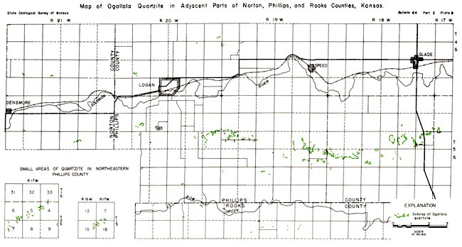
The second largest deposit in the county, estimated at 100,000 tons, occurs in the SE sec. 5, T. 5 S., R. 22 W., and crops out along the west valley wall of a tributary to North Solomon River. The rock at this locality is very fine-grained (Pl. 4, fig. 1), dense, and brown in color. The average thickness of the exposed bed is 6 feet.
In the SW sec. 28, T. 4 S., R. 21 W., quartzite is exposed along the bottom and sides of a small valley, and the hard ledge forms a sharp break in the slope of the valley bottom. The bed of quartzite is 2 feet thick and immediately overlies about 4 feet of loose sand and gravel which rests on chalky shales of the Niobrara formation. It is estimated that a minimum of 40,000 tons of rock is available.
Quartzite has also been quarried in the SE cor. sec. 30, T. 4 S., R. 21 W., where it occurs as lentils in loose sand, and at the Cen. E. line sec. 33, and Cen. W. line sec. 34, T. 4 S., R. 23 W.
A small deposit of this rock in a bed 2 feet thick occurs in the SE sec. 9, T. 5 S., R. 21 W., where it immediately overlies chalky shales of the Niobrara formation.
Phillips County
Extensive deposits of Ogallala quartzite occur in Phillips County, the total available quantity being estimated at more than 3,800,000 tons. The exposures of this rock occur widely scattered over the county and will be discussed by grouping them in four general regions: (1) an area extending from south of Glade to the Norton County line and lying south of North Solomon River, (2) the area north of North Solomon River near Logan, (3) the northeastern Phillips County area, and (4) a small area west of Woodruff.
Southern area--Outcrops of Ogallala quartzite extend in a discontinuous irregular line along the south side of North Solomon Valley and tributary valleys from sec. 7, T. 5 S., R. 17 W., to sec. 18, T. 5 S., R. 20 W., on the Norton County line. Silicified Ogallala has previously been noted in this area by Haworth (1897, pp. 267-268) and by Landes and Keroher (1942, p. 308). At the eastern extremity of this line of outcrops the quartzite represents the easternmost extent of Ogallala deposits on the North Solomon-Bow Creek divide; they immediately overlie chalky shales and limestones of the Niobrara formation, and form the cap rock of isolated buttes that contain the highest points in the local topography. Farther west, quartzite occurs at several stratigraphic positions within the Ogallala formation, the highest being about 80 feet above the base. The locations of outcrops in this area are shown on the map (Pl. 8). The total quantity of available quartzite in the southern area is estimated as more than 2,000,000 tons.
In the eastern part of this area the rock is medium-grained, green to brown in color, and ranges from 2 to 10 feet in thickness. A sizable quantity is believed to occur in the S2 sec. 14, T. 5 S., R. 18 W., and it has been quarried in the Cen. E. side of adjacent sec. 15. South of Speed the quartzite bed near the base of the formation is coarse-grained to conglomeratic, brownish green in color, and weathers red brown. In the same area a higher quartzite zone is fine-grained, green, and ranges from 1 to 5 feet in thickness. Southeast of Logan the silicified lentils occur in the lower 20 to 30 feet of the formation and are similar lithologically to the lower bed farther east. A higher silicified zone in the NE sec. 18, T. 5 S., R. 19 W., however, is very fine-grained, gray green in color, and breaks into small angular fragments. Several lentils of quartzite that occur in a vertical interval of about 40 feet have been quarried in sec. 8, T. 5 S., R. 20 W., 2.5 miles southwest of Logan. The lowermost bed, which occurs immediately above Niobrara chalky shale, is green in color and coarse-grained to conglomeratic, whereas the higher zones are very fine-grained, even-textured, and well silicified throughout.
Analytical and test data are available for two localities in the southern Phillips County region. A sample collected in sec. 9, T. 5 S., R. 18 W., contains 95.40 percent silica, shows a loss after five cycles of freeze and thaw of 0.40 percent, and has a French coefficient of abrasion of 8.3. A sample from sec. 23, T. 5 S., R. 19 W., containing 96.30 percent silica, shows a loss after five cycles of freeze and thaw of 0.17 percent, and has a French coefficient of abrasion of 10.0.
Logan area--Quartzite was examined at four localities along the north side of North Solomon Valley in the vicinity of Logan: a quarry in the SW sec. 29, T. 4 S., R. 20 W.; small outcrops in the SE sec. 13, T. 4 S., R. 20 W.; Cen. N. line, sec. 23, T. 4 S., R. 20 W.; and in the NW sec. 19, T. 4 S., R. 19 W. The available rock in sec. 29, T. 4 S., R. 20 W. is estimated at 200,000 tons. The small outcrops northeast of Logan contain very conglomeratic material that is yellow green and greenish brown in color,, and range in thickness from 1 to 10 feet. The quartzite exposed in the vicinity of the quarry situated at the top of a prominent hill about 2 miles northwest of Logan occurs immediately above chalky shales of the Niobrara formation, is 1 to 8 feet thick, and is conglomeratic at the base with light-green uniformly fine-grained rock at the top.
Northeastern area--Quartzite occurs in two small areas in northeastern Phillips County, which are approximately 2 and 7 miles south of the state line and about 11 miles west of the Smith County line. The location and extent of the outcrops are shown in detail on the maps in Plate 8. In the northernmost of these two small areas it is estimated that 75,000 tons of rock is available. It has a maximum thickness of 12 feet and ranges from fine- to coarse-grained in texture, is dense, and green in color.
Landes and Keroher (1942, p. 308) have noted the presence of quartzite in the southern of the two localities. It is now estimated that a total of a least 50,000 tons of rock occurs in this area. The distribution of outcrops is shown in Plate 8. The deposit ranges in thickness from 1 to 5 feet, is mostly bright green in color, and includes all varieties of texture from slightly conglomeratic to fine-grained.
Woodruff area--For many years the presence of quartzite in the strata lying above the Niobrara formation in several hilltops 3 to 4 miles west of Woodruff has been known. This quartzite, which occurs less than one-half mile south of the Nebraska state line, was noted by Haworth (1897, pp. 267-268), Barbour (1903, p. 163), Condra (1908, pp. 18-23 ) and Landes and Keroher (1942, p. 308). Rock has been quarried extensively in secs. 4 and 5, T. 1 S., R. 19 W. At one time a railroad spur was operated from the Oberlin branch of the Chicago, Burlington, and Quincy Railroad and quartzite from these quarries was used for railroad ballast and other purposes over a wide area, chiefly in Nebraska.
The quartzite occurs in lenticular masses in loose sand and gravel, and at a few places in the quarry face beds of fine material were observed. The zone in which the quartzite occurs is more than 12 feet in thickness but none of the individual lenses of hard rock exceeds 5 or 6 feet in thickness. It is medium-grained to conglomeratic, green to gray green in color, and according to estimate about 500,000 tons of rock is available. Samples from these quarries show the best results of any samples tested in freeze and thaw, having no loss after five cycles. Chemical analysis shows the material to have 87.00 percent silica, and the French coefficient of abrasion was determined to be 8.8.
Rawlins County
Quartzite crops out at several localities in northeastern Rawlins County along the south side of Beaver Creek, where it immediately overlies Pierre shale (Elias, 1937, p. 23), and in the southwestern part of the county a thick bed of chert occurs at a higher stratigraphic position within the Ogallala. It is estimated that more than 300,000 tons of quartzite, and as much as 500,000 tons of chert are available in the county.
Several years ago quartzite was quarried in the NW sec. 10, T. 2 S., R. 31 W., south of Herndon. In this area the rock is lenticular and interbedded with loose sand and gravel. The zone of silicification has a maximum thickness of 24 feet; the rock is green in color, and ranges from fine-textured at the top to conglomeratic near the base. Another, larger quarry is located in the NW sec. 29, T. 2 S., R. 32 W., east of Ludell. The quartzite bed here is about 10 feet thick, gray-green to green in color, and ranges from fine-grained to conglomeratic. It is characterized by a relative abundance of white feldspar grains in some zones. In the same area an older now abandoned quarry (Elias, 1937, p. 23), located in the SE, sec. 30, T. 2 S., R. 32 W., provided rock for the Ludell school (Pl. 2C).
South of McDonald in sec. 10, T. 4 S., R. 36 W., Ogallala chert is exposed for a distance of nearly a half mile along the south side of Little Beaver Creek Valley (Pl. 3A). This bed has a maximum thickness of 12 feet, is gray to white to cream colored, and has a mottled appearance on the outcrop. This area contains a larger available tonnage of Ogallala chert than any other locality examined by us. Chemical analysis shows this material to contain only 55.08 percent silica and a much larger percentage of calcium carbonate than any quartzite sample analyzed. Its loss after five cycles of freeze and thaw is 0.49 percent and the French coefficient of abrasion was determined to be 4.7, which is lower than that of any of the quartzite samples tested.
Rooks County
Quartzite occurs in the Ogallala of Rooks County along the south side of Bow Creek Valley in the northwestern corner of the county as shown in Plate 8, and as the cap rock of two buttes referred to as Twin Mounds, 6 miles northeast of Plainville. It is estimated that about 500,000 tons of silicified rock is available in the county.
South of Bow Creek Valley the outcrops extend from the vicinity of Sugar Loaf Mound in sec. 10, T. 6 S., R. 19 W., to sec. 4, T. 6 S., R. 20 W. The quartzite is lenticular and occurs at several stratigraphic positions within the Ogallala, the highest being as much as 75 feet above the contact with the Cretaceous Niobrara formation. The rock is green to brownish green in color and ranges from fine-grained to conglomeratic in texture. Chemical analysis of a sample from sec. 10, T. 6 S., R. 19 W. shows the rock to contain 96.50 percent silica. The loss after five cycles of freeze and thaw, 0.77 percent, is the highest of any quartzite sample tested, and the French coefficient of abrasion was determined to be 5.0, which is the lowest of any quartzite sample tested.
At Twin Mounds in the SE sec. 4, T. 9 S., R. 17 W., a very fine-textured variety of gray-green quartzite occurs relatively high within the lower Ogallala and forms the cap rock of these two buttes. On the southern of the two buttes the lower part of the bed has been quarried. In this area the rock has a total thickness of about 12 feet.
Smith County
Green quartzite has been quarried in the NE sec. 21, T. 3 S., R. 12 W., and an outcrop of Ogallala chert has been noted in sec. 29, T. 1 S., R. 13 W. The quartzite, which has an average thickness of about 3 feet, caps a low mound and represents the easternmost known extent of this rock in Kansas. It is green in color and the texture ranges from fine-grained to conglomeratic. It is estimated that about 30,000 tons is available in this area.
Trego County
In the southeastern corner of the county (secs. 25, 34, and 36, T. 15 S., R. 21 W.) small outcrops of cherty and calcareous fine-textured Ogallala deposits were observed in fields and along hilltops. The total quantity present is not known.
Wallace County
One outcrop of Ogallala chert was examined in the W2 sec. 7, T. 14 S., R. 38 W., Wallace County. At this locality the chert occurs high in the Ogallala and is not far below the "Algal limestone" which marks the top of the formation. The occurrence of such rock in the Tertiary of Wallace and Logan Counties was noted as early as 1874 by Mudge. As Wallace County was not explored in the search for silicified Ogallala, other and more extensive deposits of this type may be found.
Prev Page--Uses || Next Page--References
Kansas Geological Survey, Geology
Placed on web Aug. 20, 2007; originally published July 1946.
Comments to webadmin@kgs.ku.edu
The URL for this page is http://www.kgs.ku.edu/Publications/Bulletins/64_2/07_occur.html