![]()
Prev Page--Production, Reserves || Next Page--More on Counties
Wabaunsee Coal-Bearing Counties
Atchison County
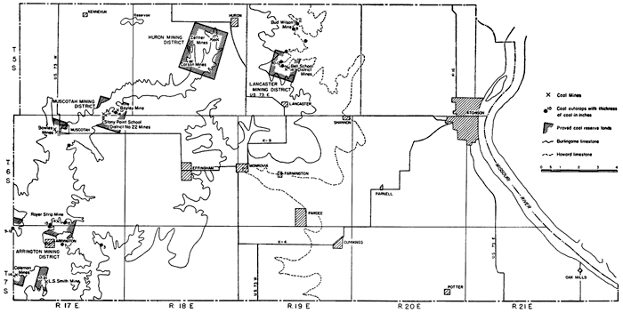
Nodaway and Elmo coals crop out in Atchison County (Fig. 9). The Nodaway coal outcrops are limited to T. 5 S., R. 19 E., north of Lancaster and east of Huron. Because of the glacial drift, outcrops of the Nodaway coal and the overlying Howard limestone formation are not numerous. The Elmo coal, on the other hand, has a wider distribution. Although it is concealed at numerous places by glacial drift, it can be traced from the northern part of the county southwest of Huron southwestward to the Atchison-Jefferson County line south of Arrington.
Figure 9--Map of Atchison County, Kansas, showing Wabaunsee group coal mining districts, location of coal mines and outcrops, proved coal reserve lands, and traces of the Howard and Burlingame limestones. [A larger Acrobat PDF version of this figure is available.]
Nodaway coal
The Nodaway coal where seen in Atchison County ranges from 7 to 14 inches in thickness. It crops out only in T. 5 S., R. 19 E.; elsewhere it is concealed beneath a covering of glacial drift. The 14-inch coal occurs in the NW sec. 21 in the bank of a small north-flowing creek (Pl. 5B). The same coal is 10 to 12 inches thick in the stream bank of an east-flowing stream in the NE sec. 20, and it measures 7 inches in the W cor. SW sec. 16. In sec. 9 the coal is 9 to 11 inches thick. The Nodaway coal underlies the Church limestone and is separated from it by gray to black shale which ranges from a featheredge to 23 inches in thickness. The Church limestone, which serves as an excellent horizon marker in searching for the coal, is a massive dark-bluish rock that weathers to a rusty brown. The rock is very hard and dense and is cut by vertical joints which cause it to break into large rectangular blocks when weathered. Its average thickness is 18 inches. The Church limestone is fossiliferous and contains especially abundant crinoid stems. Toward its top bryozoans are common. In Atchison County and as far south as Osage. County the basal Bachelor Creek limestone is absent and the Nodaway coal marks the base of the Howard limestone formation. The underlying shale, 4 to 6 feet thick, is bluish and argillaceous, and the strata beneath it consist of sandy shales and sandstones. In the NW sec. 21, T. 5 S., R. 19 E., the coal is underlain by an ash-colored sticky structureless underclay 1 foot thick. The Nodaway coal is 42 feet above the top of the Coal Creek limestone, the uppermost member of the Topeka limestone formation, in the SW cor. sec. 10, T. 5 S., R. 19 E.
In Atchison County and as far south as southern Osage County the Utopia limestone is divisible into several units consisting of limestones and dark-gray to back ostracode-bearing shales. The uppermost limestone is full of robust fusulinids. Evidence of a disconformity is indicated by the presence of a brecciated to conglomeratic sandstone which overlies the Utopia limestone or rests directly on the Winzeler shale where the Utopia limestone is missing. In approximately the Cen. SW sec. 4, T. 5 S., R. 19 E., the conglomeratic bed, 4 feet thick and highly dipping, rests on the Utopia limestone. At the top of the conglomerate is a discontinuous coal seam, 3 to 5 inches thick, which is overlain by sandstone containing numerous fine coal streaks. At the mine in the southern part of the NW sec. 21, T. 5 S., R. 19 E., about 2 miles north of Lancaster, the conglomerate bed also rests on the Utopia limestone, whereas about 1,000 feet farther north the Utopia limestone is missing and the conglomerate lies directly on part of the Winzeler shale.
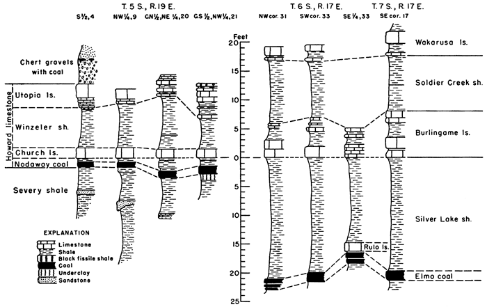
Stratigraphic sections showing the Nodaway coal in relation to overlying and underlying strata are presented in Figure 10.
Figure 10--Stratigraphic sections showing Nodaway and Elmo coals and their relation to adjacent rocks in Atchison County, Kansas. [A larger Acrobat PDF version of this figure is available.]
The Nodaway coal has been and still is being mined by farmers on whose land the coal crops out. It crops out in stream banks and can be mined without much difficulty along the face of the outcrop. As far as I could ascertain, the Wabaunsee coal was formerly mined at one place in the county by shaft mining and at two localities by the slope or drift method. In the S2 NW sec. 21, T. 5 S., R. 19 E., immediately north of the east-west half section line and about 0.2 mile east of the west section-line road, is the remnant of a shaft mine from which much coal must have been taken if the presence of an abandoned blacksmith shop and scattered cable close to the shaft have any significance. The shaft could not have been more than 30 feet deep. Approximately 0.2 mile north of the shaft are the traces of two drift mines. Another drift mine, now caved in and operated by Bud Wilson of Huron in 1910, is in the east bank of a stream in the SW sec. 4, about 3 miles east of Huron.
Elmo coal
The Elmo coal crops out at more places than the Nodaway coal and has been mined more extensively. Because of the thick mantle of glacial drift, the Elmo coal is concealed at many places and cannot be traced continuously across the entire width of the county. The best and most numerous outcrops of the coal are along the face of the Burlingame limestone escarpment in T. 7 S., R. 17 E. in the area surrounding Arrington and Larkinburg in adjoining Jackson County. The Elmo coal is also known to occur at the southwest edge of Muscotah; 0.75 of a mile south of the southeast corner of Muscotah; in the Stony Point school district, 2 to 3 miles east and 1 mile north of the southeast corner of Muscotah; on the Zeltner farm in the southern part of sec. 11, T. 5 S., R. 18 E., about 1 mile west and 1 mile south of Huron; and in the NW sec. 22, T. 5 S., R. 18 E.
The Elmo coal occurs in the upper part of the Cedar Vale shale formation or immediately beneath the Rulo limestone (Fig. 2). The Rulo limestone is an impure rock and is not everywhere present. Where the Rulo limestone is missing it is impractical to differentiate between the lower Cedar Vale and the upper Silver Lake shale formations. As a coal occurs locally in the Silver Lake shale, it cannot be established with certainty that the first coal underlying the Burlingame limestone at places where the Rulo limestone is missing is the Elmo coal. For the purposes of this report, the first coal beneath the Burlingame limestone is considered the Elmo coal at those places where the Rulo limestone is missing and where only one coal is present.
The Elmo coal as seen in outcrops is 7 to 15.5 inches thick and, according to local residents, ranges from 17 to 21 inches in thickness where mined. Where the Rulo limestone is present, as at the Clyde Royer strip mine in the SE sec. 33, T. 6 S., R. 17 E., 1 mile north and one-half mile east of Arrington, the coal is practically in contact with the limestone, being separated from it by no more than 3 inches of coaly shale. About one-half mile west of the strip mine along the section-line road a good exposure of rocks from the Wakarusa limestone to the coal reveals no Rulo limestone. The shale between the coal and the base of the white sugary-like basal Burlingame limestone is gray to bluish and is 20 feet thick. One mile north of Larkinburg in the NW cor. sec. 31, T. 6 S., R. 17 E., a similar relationship exists. At this locality the shale between the coal and the basal Burlingame bed is 21.5 feet thick, clayey, and blue to black in color. In a road cut on the Arrington-Cummings highway, about 0.5 mile east of Arrington in sec. 4, T. 7 S., R. 17 E., the coal, 7 inches thick, is overlain and underlain by shale with no Rulo limestone present. Less than 0.25 mile farther west on the same highway the total thickness of the coal is 15 inches. Unlike the Nodaway coal, the Elmo coal at places is split into two or three units. In the outcrop 0.25 mile south and east of the Royer strip mine in sec. 33, T. 6 S., R. 17 E., north and east of Arrington, a 1-inch clay seam divides the coal into two units of 3 and 6.5 inches respectively, and in the road cut 1 mile north of Larkinburg in the W cor. sec. 31, T. 6 S., R. 17 E., the coal consists of three units, 8, 4, and 1. inch thick separated by clay seams 1 and 4 inches thick. Similarly, 0.2 mile east of the east edge of Arrington on the Arrington-Cummings road in sec. 4, T. 6 S., R. 17 E., the coal is split into three 5-inch units separated by 1- and 2-inch clay seams.
Elmo coal has been mined on the Clarence Zeltner farm (former Hugh Kelley place) in the southern part of sec. 11, T. 5 S., R. 18 E., about 1 mile west and 1 mile south of Huron. According to Mr. Zeltner the coal was 17 inches thick. Only four coal dump piles may still be seen on the Zeltner place, but according to Bud Wilson of Huron, coal was mined from two shaft mines and at least five drift mines which on the average were 300 feet long. Mining started in about 1883 and ceased in 1910. The coal is not exposed on the Zeltner place. According to Wilson, the coal consisted of two seams, the upper of which was 12 to 14 inches thick and the lower, separated from the upper by 1.5 to 3 inches of shale, measured 3 inches in thickness. Elmo coal was also mined by stripping and drifting on the Carson farm in the NW sec. 22, T. 5 S., R. 18 E. From 40 to 50 years ago Elmo coal was mined by drifting in the Stony Point school district about 2 to 3 miles east and 1.25 miles north of Muscotah. About 0.2 mile north and 0.15 mile east of the school, in the SW cor. SE sec. 35, T. 5 S., R. 17 E., coal dump piles and trenches reveal the former existence of three drift or slope mines. Likewise along the escarpment face in sec. 2, T. 6 S., R. 17 E., less than 0.2 mile west and no more than 0.25 mile south of the school, remnants of other mines abandoned long ago are faintly in evidence. According to Norman Plummer of the Geological Survey staff, who as a youth lived in the Stony Point school district, coal was mined last in this locality about 40 years ago. As far as could be determined the coal lies approximately 20 feet below the base of the Burlingame limestone. No coal outcrops are visible at the present time around the school. In the Bayley pasture about 0.65 mile east of the school and 0.15 mile north, in the SW SW sec. 36, T. 5 S., R. 17 E., the Elmo coal crops out in a stream bank close to water level. The coal is 16 inches thick and is 39 feet below the first visible overlying limestone. A second outcrop occurs in the stream bed of a small tributary coming from the east about 0.25 mile north and 0.2 mile east of the 16-inch coal outcrop. Coal was also mined in this section close to the junction of the two creeks in whose banks the coal outcrops just mentioned occur. Elmo coal was also mined on the Bryan Bowles place at the west edge of Muscotah in the SW sec. 4, T. 6 S., R. 17 E. Several drift mines indicated by traces of trenches and coal dump piles are still to be seen in the bluffs of Grasshopper or Delaware Creek just west and north of the barn northwest of the Bowles residence. The most recent mine is a strip mine on the Clyde Royer place in the SE sec. 33, T. 6 S., R. 17 E. This mine was operated as late as 1942. Coal was stripped from 2 to 3 acres. A clean bank on the strip pit at the time of my visit showed the, coal to be 14 inches thick. On the basis of this thickness, about 5,000 tons of coal were mined at this place. A drift mine was operated in about 1900 in the SE cor. sec. 17, T. 7 S., R. 17 E. Part of the coal vein is still visible close to the mine entrance. The coal is reported to have had a thickness of 17 to 21 inches. Several other drift or slope mines are located in the river bluff approximately 2 miles west and 0.3 mile north of the mine in sec. 17. These mines are on the Coleman place in the SW sec. 18, T. 7 S., R. 17 E., a little more than 1.5 miles south of Larkinburg on the Atchison-Jackson County line. The coal, 14 inches thick, crops out west of the mine in a road cut on the Atchison County side of the road in the SW sec. 18.
Production
Coal has been mined in Atchison County from at least 30 Wabaunsee coal mines (Table 12), of which 3 were shaft mines, 25 drift mines, and 2 strip pits. Four of the mines produced Nodaway coal, whereas 26 derived their coal from the Elmo coal bed. Except for the period previous to 1877 (Wilson, 1898, p. 113) when practically all the coal used in Atchison County came from the Elmo coal vein and such towns as Effingham secured their entire coal supply from this source, the Wabaunsee coals of the county may be considered essentially noncommercial. All the mines have been operated primarily by local residents or local coal companies to supply fuel for domestic purposes in the immediate vicinity of the mines. For those reasons coal production data have not been recorded with the state coal mine inspectors and consequently are not found in the official reports of the state or federal governments. Production figures, therefore, must be estimates. If it is assumed that each of the 25 drift mines was operated an average of 5 years, that the minimum thickness of the coal is 12 inches, and that no more than one acre of coal has been extracted from each mine, the estimated production of the drift mines is approximately 39,000 tons. To this amount should be added the estimated 5,000 tons of coal stripped north of Arrington and that mined in the three shaft mines. In addition some coal has been mined by individuals from the face of the outcrops. A reasonable estimate of the cumulative production of Wabaunsee coal mined in Atchison County is 46,000 tons. It should be noted, however, that this does not represent the total amount of coal mined in the county, for in the vicinity of Atchison much coal has been mined in the past from veins stratigraphically lower than the Wabaunsee group.
Table 12--Location and classification by type of mine of coal mines in the Wabaunsee group in Atchison County, Kansas.
| Location | Number of mines | Coal bed |
||||
|---|---|---|---|---|---|---|
| Shaft | Drift or slope |
Strip | ||||
| SW | 4-5-19E | Bud Wilson mine | 1 | Nodaway | ||
| NW | 21-5-19E | Bell School district | 1 | 2 | Nodaway | |
| SW | 11-5-18E | Zeltner farm | 2 | 5 | Elmo | |
| SE | 15-5-18E | 1 | Elmo | |||
| NW | 22-5-18E | Carson farm | 1 | 1 | Elmo | |
| SE | 35-5-17E | Stony Point school, District 22 |
3 | Elmo | ||
| NE | 2-6-17E | Stony Point school, District 22 |
2 | Elmo | ||
| SW | 36-5-17E | Bayley pasture | 1 | Elmo | ||
| SW | 4-6-17E | Bowles place | 4 | Elmo | ||
| SW | 33-6-17E | Clyde Royer farm | 1 | Elmo | ||
| SW | 18-7-17E | Coleman farm | 4 | Elmo | ||
| SE cor. | 17-7-17E | L. S. Smith farm | 1 | Elmo | ||
| Total | 3 | 25 | 2 | 30 | ||
Proved reserves
Of the Wabaunsee coal mines in Atchison County, all but four are drift mines along the edge of the escarpments. Therefore, little of the coal has been mined thus far and considerable reserve coal exists. In secs. 20 and 21, T. 5 S., R. 19 E., 1.5 to 2 miles north of Lancaster, there are 940 acres underlain by Nodaway coal averaging 12 inches in thickness. Approximately 1,410,000 tons of minable Nodaway coal underlie these proved reserve lands. Practically all this coal lies less than 35 feet beneath the surface; it is therefore available by stripping methods.
In the Zeltner-Carson district southwest of Huron the Elmo reserve coal lands include all or parts of secs. 9, 10, 11, 14, 15, 16, 21, 22, and 23, T. 5 S., R. 18 E., and total 2,240 acres. The coal underlying this area averages 17 inches in thickness and is all within the depth limit for shafting. Approximately half of it could be mined by stripping. The proved coal reserve of these lands amounts to 4,760,000 tons of Elmo coal. In the Stony Point School district northeast of Muscotah 1,950,000 tons of 16-inch Elmo coal underlies the 973 acres of proved coal reserve lands. The proved area comprises parts of secs. 35 and 36, T. 5 S., R. 17 E., and secs. 1 and 2, T. 6 S., R. 17 E. At Muscotah 269 acres are underlain by 17-inch Elmo coal, or 570,000 tons. North of Arrington in the southern part of sec. 33, T. 6 S., R. 17 E., and in the northern part of sec. 4, T. 7 S., R. 17 E., the proved Elmo coal is 14 to 15.5 inches thick and underlies 544 acres. On the basis of an average of 15 inches for the thickness of the coal, the 544 proved reserve coal acres contain 1,020,000 tons of minable coal. Most of this coal can be mined by stripping as has been done on the Royer property in sec. 33. In the southwest corner of the county in secs. 17, 18, 19, and 20, T. 7 S., R. 17 E., the proved coal reserve lands are estimated at 617 acres. Of these, 269 acres are underlain by 14-inch Elmo coal and 352 acres by 17-inch coal. The proved tonnage of the 14-inch coal which is exposed near the Coleman mines in sec. 18 amounts to 470,000 tons whereas 750,000 tons underlie the L. C. Smith mine and vicinity in secs. 17 and 20. North of Larkinburg, the Elmo coal is 12 inches thick. The 260 acres of proved coal reserve lands should yield approximately 390,000 tons of Elmo coal.
In summary, the proved reserve coal lands of the Wabaunsee group in Atchison County total 5,847 acres, of which 940 acres are underlain by the Nodaway coal and 4,907 acres contain Elmo coal. Quantitatively there are 11,320,000 tons of proved reserve coals composed of 1,410,000 tons of Nodaway coal and 9,910,000 tons of Elmo coal. Reserve coal acreage and tonnage by mining districts is presented in Table 13.
Table 13--Proved and potential Wabaunsee group coal reserve lands and tonnage by mining districts in Atchison County, Kansas
| Coal bed |
Mining district or coal reserve area |
Mine | Location | Proved reserves | Potential reserves | ||||
|---|---|---|---|---|---|---|---|---|---|
| Average thickness of coal, inches |
Acres | Tons | Average thickness of coal, inches |
Sq. miles |
Tons | ||||
| Nodaway | Lancaster | Bell School | 20,21-5-19E | ||||||
| Bud Wilson | 4-5-19E | 12 | 940 | 1,410,000 | 12 | 120 | 115,210,000 | ||
| Elmo | Huron | Zeltner- Carson |
9,10,11,14,15,16, 21,22,23-5-18E |
17 | 2,240 | 4,760,000 | 12 | 143 | 137,210,000 |
| Muscotah | Stony Point school |
35-5-17E 1,2-6-17E |
16 | 979. | 1,950,000 | ||||
| Bayley | 36-5-17E | 16 | |||||||
| Bowles | 4-6-17E | 17 | 269 | 570,000 | |||||
| Arrington | Royer | 33,34-6-17E | 15 | ||||||
| 4,5-7-17E | 14 | 544 | 1,020,0100 | ||||||
| Coleman | 18,19-7-17E | 14 | 269 | 470,000 | |||||
| L. S. Smith | 17,20-7-17E | 17 | 352 | 750,000 | |||||
| Larkinburg | 31-6-17E 6-7-17E |
12 | 260 | 390,000 | |||||
| Total | 5,847 | 11,320,000 | 263 | 252,420,000 | |||||
Potential reserves
On the basis of the adopted method of computing potential coal reserve lands and tonnage, all of Atchison County west of the trace of the Burlingame limestone (Fig. 9) is underlain by Elmo coal. This area comprises 143 square miles. On the assumption that the average thickness of the coal is 15 inches, 171,600,000 tons of coal lie beneath its surface. The more conservative figure of 137,210,000 tons, given in Table 13, is based on an estimated 12-inch average thickness of coal. The potential reserve Nodaway coal lands comprise 120 square miles and contain 115,210,000 tons of 12-inch coal. Thus there are calculated to be 263 square miles of potential reserve coal lands in Atchison County containing 252,420,000 tons of 12-inch Wabaunsee group coals (Table 13).
Noncommercial coal
In addition to the proved and potential coal reserves there is much coal that can be recovered in a noncommercial manner by farmers and others at places where the coal averages less than 10 inches in thickness and where it is easily accessible. A favorable locality for such outcrop mining is in secs. 4 and 9, T. 5 S., R. 19 E., about 3 miles east of the east edge of Huron. Years ago Bud Wilson of Huron operated a drift mine in sec. 4. The coal measures 11 inches close to the mine, but is only 9 inches thick less than 0.25 mile distant in a north-south direction from the now-abandoned drift mine.
Brown County
All the eastern half of Brown County and parts of Ts. 1, 2, 3, and 4, R. 16 E. are underlain by rocks of Wabaunsee age with all formations but two present (Fig. 11). Four coals crop out in the county. Of these, only the Elmo coal has been mined; one other, the Lorton coal, is minable. The coal in the Wamego shale below the Maple Hill limestone and the Nyman coal in the Langdon shale beneath the Dover limestone are less than 6 inches thick and unminable.
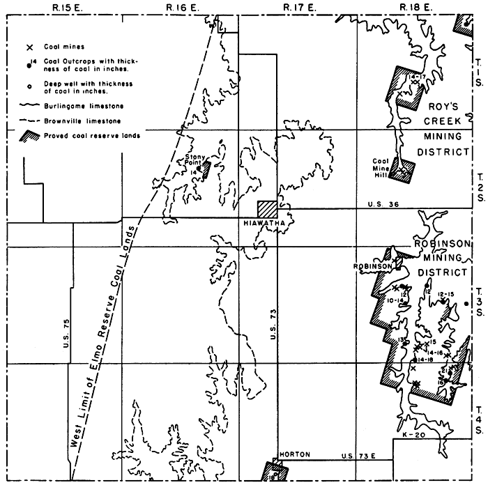
Figure 11--Map of Brown County, Kansas, showing coal mining districts, location of coal mines and outcrops, proved coal reserve lands, and traces of the Burlingame and Brownville limestones.
Elmo coal
The most important coal in Brown County is the Elmo coal. It crops out principally in the eastern part of the county in the four townships of R. 18 E. in Brown County (Fig. 11). The coal ranges in thickness from 12 to 18 inches and at most places is directly overlain by the Rulo limestone, which in Brown County is 1 to 3 feet thick. The coal lies 10 to 26 feet below the base of the Burlingame limestone. Beneath the coal is the Cedar Vale shale which is 17 to 23 feet thick. At the abandoned strip mine in the NE cor. sec. 34, T. 3 S,, R. 18 E., the coal consists of two seams separated by an underclay 2 1/2 inches thick. The upper seam is 12 inches thick and the lower one 3 inches. Beneath the lower seam are 12 inches of ash-colored underclay. The coal is also exposed in a ditch at the north end of the now inactive limestone quarry in sec. 15, T. 3 S., R. 18 E., approximately 1.5 miles east and 0.75 mile south of the southeast corner of Robinson. The coal is 12 inches thick and occurs 16 feet 6 inches below the base of the Burlingame limestone formation, the strata of which show slight disturbance. No Rulo limestone is present at this locality.
The presence of Elmo coal in Brown County was known about the time of the first settlements in 1854 and 1855. As early as 1866, Mudge (1866, p. 18), Swallow (1866, p. 56), and Hawn (Swallow, 1866, p. 102) noted the occurrence of several coal horizons in the county. Mudge (1866, p. 18) states that the coal was- mined at various points in Brown and Doniphan counties and that it was seldom more than 12 inches thick. Hawn (Swallow, 1866, p. 102), on the other hand, described the Elmo coal as being 14 to 30 inches thick and of good quality. According to Hawn, much coal was mined on Roys Creek at the crossing of the upper road from White Cloud in Doniphan County to Hiawatha. The coal is reported to have been 30 inches thick and was mined by shafting. The coal also has been worked on the west fork of Nemaha Creek where the seam is thought to have a great lateral extent. Hawn correlated the Brown County coal with the Burlingame or Nodaway coal of Osage County. He also referred to the coal cropping out and mined on Wolf Creek near Robinson. This coal, reported at one place to be 36 inches thick, Hawn believed to be from 50 to 100 feet stratigraphically below the coal mined along Roys Creek. It is now known that the coal at the two places is from the same zone and is the Elmo coal. Stripping of coal in 1875 is also reported by Mudge (1875). Coal was mined southeast of Robinson as late as 1934 and is worked locally at the present time by farmers who use the coal for their own fuel supplies.
Elmo coal has been worked in Brown County in 30 mines, most of which are located along the bluffs of the South Fork of Wolf Creek south of Robinson (Fig. 12). The coal was worked by drifting at most mines, by stripping at two mines, by shafting at three mines, and by taking the coal from the face of the outcrop in two places. Details on the location of the mines are presented in Table 14.
Figure 12--Map of the Robinson coal mining district, Brown County, Kansas, showing location of mines and coal outcrops, proved coal reserve lands, and traces of the Burlingame, Reading, and Tarkio limestones.

Table 14--Location and classification by type of mine of Elmo coal mines in Brown County, Kansas.
| Location | Number of mines | |||||
|---|---|---|---|---|---|---|
| Shaft | Drift or slope |
Strip | Outcrop | Total | ||
| NW cor. SW | 22-1-18E | 1 | 2 | 3 | ||
| NW | 28-1-18E | 1 | 1 | |||
| NE cor. NW | 16-2-18E | 2 | 2 | |||
| SW | 4-3-18E | 1 | 1 | |||
| SE cor. SW | 14-3-18E | 1 | 1 | |||
| NW cor. | 16-3-18E | 3 | 3 | |||
| NE | 16-3-18E | 3 | 3 | |||
| NE | 34-3-18E | 1 | 1 | |||
| NW | 34-3-18E | 4 | 4 | |||
| SW | 34-3-18E | 1 | 1 | |||
| SE | 35-3-18E | 1 | 1 | 1 | 3 | |
| NE | 2-4-18E | 2 | 2 | |||
| NE | 4-4-18E | 1 | 1 | |||
| NW | 10-4-18E | 1 | 3 | 4 | ||
| Total | 3 | 23 | 2 | 2 | 30 | |
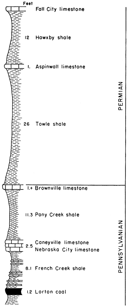
Lorton coal
In the extreme NE cor. sec. 15, T. 2 S., R. 16 E., 1.5 miles east and 2 miles south of Hamlin at a place known locally as Stony Point is a 14-inch coal. The coal crops out near the base of a road bank but, on account of the steepness of the bank and nonresistant nature of the rocks, the coal is commonly buried beneath an accumulation of weathered rock waste and thus hidden from view. This is the Lorton coal. It occurs in the French Creek shale formation 8 feet 2 inches below the Nebraska City limestone member of the Caneyville limestone formation (Fig. 13). The coal lies 2"L feet below the base of the Brownville limestone, which marks the contact between the Pennsylvanian and Permian rocks in Kansas. The complete stratigraphic section at the Stony Point outcrop is given below.
| Measured section at Stony Point, NE cor. sec. 15, T. 2 S., R. 16 E., east road bank, west-facing slope of hill | Thickness | |||
|---|---|---|---|---|
| Feet | Inches | |||
| PERMIAN-Wolfcampian | ||||
| Falls City limestone | ||||
| 10. Limestone, large rectangular slabs; contains fossils | ||||
| 9. Shale, light bluish green | 12 | |||
| Hawxby shale | ||||
| 8. Limestone, weathers white; thickness not determinable, probably thin | ||||
| 7. Shale, more or less covered | 26 | |||
| PENNSYLVANIAN-Virgilian | ||||
| Brownville limestone | ||||
| 6. Limestone, poorly exposed | ||||
| Pony Creek shale | ||||
| 5. Shale, sandy | 11 | 4 | ||
| Caneyville limestone | ||||
| 4. Limestone (Nebraska City member), impure, silty, weathers crumbly, ashy gray | 2 | 6 | ||
| French Creek shale | ||||
| 3. Shale, gray brown; contains thin sandy limestones about 1 inch thick distributed throughout the shale | 8 | 2 | ||
| 2. Coal, Lorton | 1 | 2 | ||
| 1. Shale, gray | ||||
Figure 13--Stratigraphic section at Stony Point, Brown County, Kansas, showing Lorton coal and its relation to adjacent rocks.
The Lorton coal crops out about 0.5 mile north and 0.25 mile east of the Stony Point outcrop in the NW sec. 11, T. 2 S., R. 16 E., and at water level of Walnut Creek in the SE sec. 21, T. 2 S., R. 16 E. At the latter locality the coal is 6 inches thick and lies 10 feet beneath the Nebraska City limestone member of the Caneyville formation. The Lorton coal occurs at other places in the county but is too thin to be mined.
Other Wabaunsee coals
Coals of two other Wabaunsee zones are present in Brown County. Both coals, however, are less than 6 inches thick and thus are unminable; therefore, they are not considered important for purposes of this report. In the upper part of the Wamego shale close to the Maple Hill limestone is an unnamed thin coal which crops out at the southeast end of the dam at Mission Lake at Horton and in the surrounding vicinity. The other coal, the Nyman, underlies the Dover limestone. It is in the upper part of the Langdon shale and crops out at a number of places between Horton and Mercier.
Production
Coal production figures for Brown County are very incomplete. The only ones published in official reports are those given in Table 15. Without doubt, coal has been mined in the county since 1854, when the first settlements were established in the coal-bearing area. Production records, however, are available for only 5 of the 43 years from 1854 to 1897. The average production for those years is 2,540 tons per year. Assuming an average yearly production of 2,000 tons for the unrecorded 38 years, an additional 76,000 tons should be added to the 12,700 tons listed in Table 15, a total of 88,700 tons. Coal production, however, did not cease with 1897, for it is known that coal was mined southeast of Robinson as late as 1934. It is not unlikely that 100,000 tons of coal have been mined in Brown County.
Table 15--Published coal production data for Brown County, Kansas.
| Year | Tons mined |
|---|---|
| 1878 | 2,000 |
| 1894 | 2,000 |
| 1895 | 3,400 |
| 1896 | 3,000 |
| 1897 | 2,300 |
| Total | 12,700 |
Proved reserves
The proved coal reserve lands of Brown County comprise 19.6 square miles underlain by Elmo coal and 160 acres underlain by Lorton coal. There are 23,160,000 tons of proved Elmo coal reserves and 280,000 tons of Lorton coal, a total of 23,440,000 tons of reserve coal. Of the proved Elmo reserve coal, 1,440,000 tons are calculated on the basis of a diamond drill record at Horton where an 18-inch coal lies 131 feet beneath the surface at a depth favorable for shaft mining. Data concerning the proved coal reserves by mining districts are presented in Table 16.
Table 16--Proved and potential Wabaunsee group coal reserve lands and tonnage by mining districts in Brown County, Kansas.
| Coal bed |
Mining district or coal reserve area |
Location | Proved reserves | Potential reserves | ||||
|---|---|---|---|---|---|---|---|---|
| Average thickness of coal, inches |
Sq. miles |
Tons | Average thickness of coal, inches |
Sq. miles |
Tons | |||
| Elmo | White Cloud | 1-3-18E | 12 | 0.75 | 720,000 | |||
| Roys Creek | 22,28-1-18E | 16 | 1.96 | 3,510,000 | ||||
| Coal Mine Hill | 16-2-18E | 16 | 0.90 | 1,110,000 | ||||
| Robinson | 4,5,8,14,15, 16,17,20,21, 23,24-3-18E |
12 | 7.38 | 7,080,000 | 15 | 380 | 456,000,000 | |
| Robinson | 26,27,35, 36-3-18E |
16 | 5.40 | 7,110,000 | ||||
| Robinson | 1,2,3,9,10, 11,12-4-18E |
|||||||
| Robinson | 2,8,29,32, 33-3-18E |
13 | 2.2 | 2,290,000 | ||||
| Robinson | 4.5,8,9-4-18E | |||||||
| Horton | 32-4-17E | 18 | 1 | 1,440,000 | ||||
| Lorton | Stony Point | 15-2-16E | 14 | 0.25 | 280,000 | 14 | 200 | 224,000,000 |
| Totals | 19.84 | 23,540,000 | 580 | 680,000,000 | ||||
| Production | 100.000 | 100,000 | ||||||
| Net reserves | 23,440,000 | 679,900,000 | ||||||
Potential reserves
Essentially the eastern three-fourths or about 380 square miles of Brown County is underlain by potential Elmo coal reserves. The coal ranges in thickness from 12 to 18 inches with the 16- to 18-inch thickness predominating. Assuming that 15 inches is the average thickness of the Elmo coal for the entire potential area, there are 456,000,000 tons of potential reserve coals less the 100,000 tons already mined, or a net total of 455,900,000. The Lorton potential coal reserve lands comprise 200 square miles and contain 224,000,000 tons of 14-inch coal. The total potential coal reserves of Brown County amount to 679,900,000 tons (Table 16).
Chautauqua County
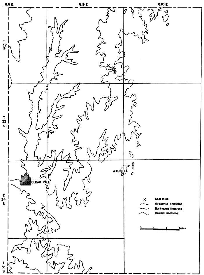
Rocks of Wabaunsee age crop out in the western one-third of Chautauqua County, chiefly in Ts. 8 and 9, Rs. 32, 33, 34, and 35 E. (Fig. 14). Except for Leeds and its immediate vicinity, in secs. 25, 26, and 36, T. 32 S., R. 9 E., the coal is everywhere too thin to be mined. No coal more than 6 inches thick was observed and at most places it ranged in thickness from a featheredge to 2 inches.
Figure 14--Map of Chautauqua County, Kansas, showing location of coal mines and traces of the Howard, Burlingame, and Brownville limestones.
Elmo coal
The only coal mined commercially in Chautauqua County is the Elmo coal. Five abandoned drift or slope mines are located in the vicinity of the former town of Leeds. The mines were operated from 1890 to 1903 and occasionally since that time. The entrance to a mine in the Cen. SE sec. 26 is still visible. According to Whitla (1940, p. 32) this mine was operated as recently as 1939. The coal in the mines is the Elmo coal and occurs 41 feet 4 inches below the base of the Burlingame limestone (Fig. 15). Whitla (1940, pp. 32-33) believed that the coal, which he says was 18 inches thick, was the Nodaway coal and that the limestone partly exposed at the mine entrance was the Church limestone member of the Howard limestone formation. A study of the geology of the mine area (Figs. 15 and 16), however, reveals that the mine entrance is located between the outcrop of the Burlingame and Happy Hollow limestones and that its entrance or portal is approximately 30 feet below the base of the Burlingame limestone. The outcrop of the basal Howard limestone is 0.5 mile east of the mine. The 4-foot limestone partly exposed at the mine entrance and 7 feet above the coal is the Rulo limestone, not the Church limestone as Whitla believed. The Leeds coal was mined by the room and pillar method. It was used chiefly in the former town of Leeds, although some of the coal was trucked to Cedar Vale, Arkansas City, and Winfield. Two of the mines are located in the SE sec. 25, one in the SW sec. 26, and at least two in the NW sec. 36, T. 12 S., R. 9 E. Whitla (1940, p. 33) also states in his report that a mine is reported to have been worked near Cedar Vale in 1938. Several abandoned slope mines are located several miles southwest of Cedar Vale in adjoining Cowley County, but none were seen near this town by me or are known to exist by local residents in Chautauqua County.
Figure 15--Stratigraphic section in the Leeds coal mining district, Chautauqua County, Kansas, showing the position of the coal.
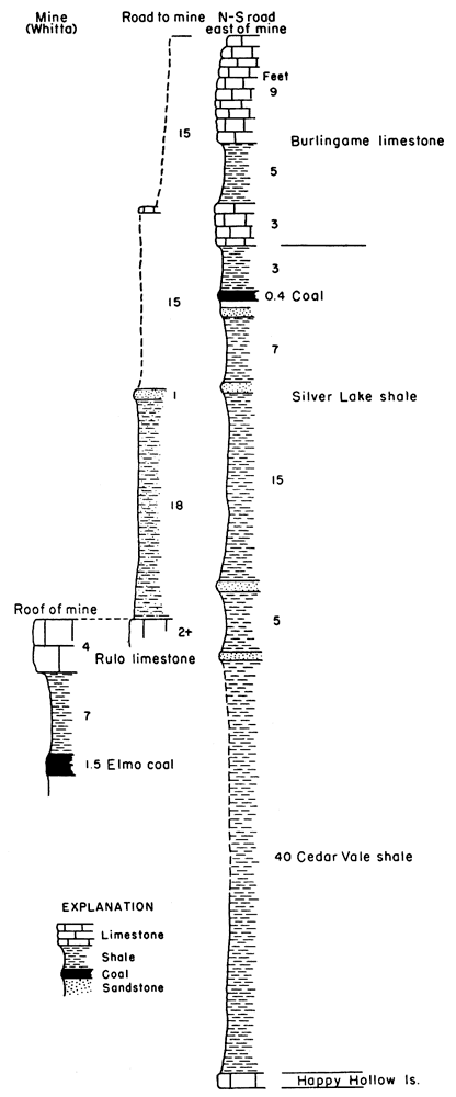
Figure 16--Map of the Leeds coal mining district, Chautauqua County, Kansas, showing the location of coal mines, proved Elmo coal reserve lands, and traces of the Wabaunsee group limestones.
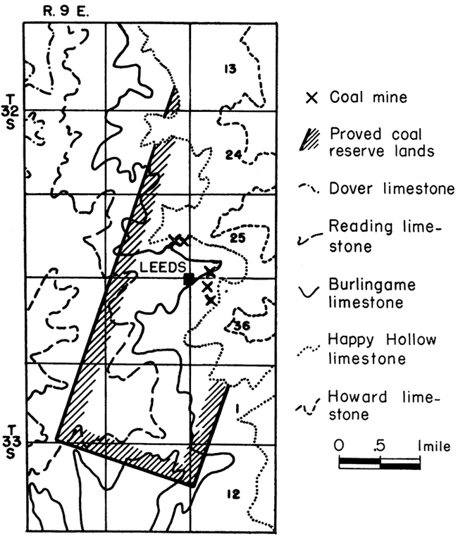
Table 17--Published coal production data for Chautauqua County, Kansas
| Year | Tons |
|---|---|
| 1880 | 400 |
| 1890 | 1,480 |
| 1891 | 1,528 |
| 1893 | 1,760 |
| 1894 | 1,520 |
| 1895 | 3,000 |
| 1896 | 5,000 |
| 1897 | 1,200 |
| 1899 | 600 |
| 1900 | 1,100 |
| 1901 | 1,400 |
| 1902 | 800 |
| 1903 | 185 |
| Total | 20,273 |
Production
Chautauqua County has produced a cumulative minimum of 20,273 tons of coal (Table 17), according to published records. An estimated 15,000 tons might reasonably be added to this amount to allow for almost 40 years for which no data are available. The total coal production for the county, therefore, is approximately 35,273 tons.
Reserves
In Chautauqua County there are 4 square miles of proved reserve coal lands underlain by 18-inch coal containing about 5,720,000 tons of Elmo coal (Table 11). The potential Elmo coal reserve lands in the county comprise 150 square miles and contain 216,020,000 tons of coal.
Coffey County
Wabaunsee coal-bearing rocks are present in only about 20 of the 656 square-mile area of Coffey County. Of the 20 square miles, 16 are in the Lebo district in the northwest corner of the county (Fig. 17). The Howard limestone escarpment along which the coal has been stripped extends in an irregular pattern across this corner of the county. The Howard limestone also crops out at four places in the westernmost tier of sections in Ts. 21 and 22, R. 13 E., but because of the general flatness of the county no coal outcrops were seen.
Nodaway coal
Nodaway coal is the only coal of the Wabaunsee group present in Coffey County. A stratigraphically lower coal in the Lawrence shale of the Douglas group, however, crops out in the southeastern part of the county. There have been extensive strip and drift or slope mining along the edge of the Howard limestone escarpment at and northwest of Lebo (Fig. 17).
Figure 17--Map of parts of Coffey, Osage, and Lyon counties, Kansas, showing Nodaway coal mining district, location of coal mines and outcrops, proved coal reserve lands, and traces of the Howard and Burlingame limestones.
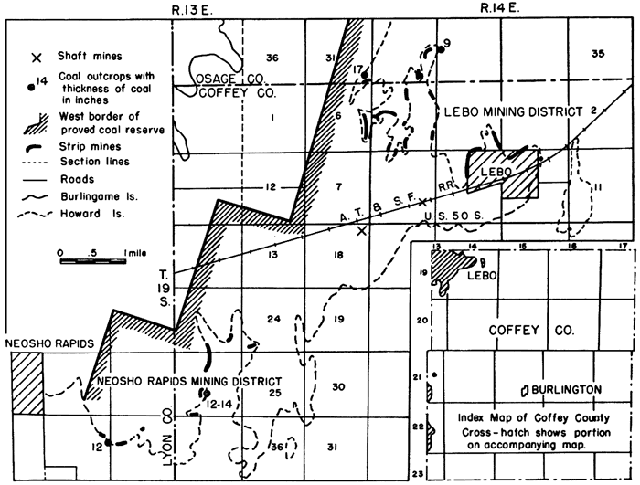
This mining area is a southern extension of the Arvonia mining district of Osage County. A second strip mining district is in secs. 23, 24, and 26, R. 19 S., R. 13 E., southwest of Lebo and 2 to 3 miles east of Neosho,Rapids in Lyon County. According to Keegan (1900, p. 69) a shaft mine was operated by G. H. Slead 2.25 miles east of Neosho Rapids in 1899. The mine was 14 feet deep and the shaft opening was 5 by 9 feet. The coal averages 12 inches in thickness, was mined by the longwall system, and sold for $2.50 per ton. In 1899 there were 21 mines producing coal in the county.
Although no coal outcrops were seen in Coffey County, the Nodaway coal, 17 inches thick, is exposed in an abandoned strip pit about 300 feet north of the Coffey-Osage County line in the SE cor. sec. 31, T. 18 S., R. 14 E. According to reports of the Kansas coal mine inspectors and local residents, the coal in Coffey County ranges in thickness from 13 to 15 inches. The actual number of mines in the county is difficult to ascertain as most of them are strip mines, many of which are contiguous. There are approximately 20 mines in the Lebo district and 6 in the Neosho Rapids mining district. In addition there are at least 3 shaft mines and several drift mines. The total number of Nodaway coal mines in the county is between 30 and 35.
Production
No Nodaway coal is mined commercially in Coffey County at the present time; the last reported production was for the year 1937 (O'Donnell, 1938, p. 11). [Note: When this report went to press (November 1946) a new strip mine was being opened by Alton Thorne at the north limits of Lebo in the SE sec. 4, T. 19 S., R. 14 E.] It is not known when commercial coal mining first started in the county. However, in 1875 coal was shipped on the Missouri, Kansas, and Texas Railroad, and on the county map for 1875 which accompanied the Fourth Annual Report of the State Board of Agriculture (pp. 232-233), a coal mine is shown in. secs. 5 and 8, T. 19 S., R. 14 E., about 1 mile west of the present site of Lebo.
Commercial coal mining in the county has not been continuous. The first and longest period ended in 1902. According to published records, coal mining on a smaller scale was resumed in 1933 and continued until 1937. During those 5 years 7,729 tons of coal were produced, 2,409 tons by shafting and 5,320 tons by stripping. In the early 1890's, the production of coal exceeded 17,000 tons annually. The greatest production was in 1899 when 39,740 tons of coal valued at $99,250 were produced (Keegan, 1900, p. 69). During that year 21 mines were in operation and 266 men and 56 teams were employed. T. R. and D. O. Jones alone mined 25,000 tons of coal during that year. According to published records, the cumulative total amount of Nodaway coal mined in the county is 154,603 tons (Table 18). A possible 45,000 tons might be added to this amount to represent the 19 years before 1887 and the 36 years between 1903 and 1943 when some coal undoubtedly was mined although there are no production records. The cumulative production of Nodaway coal in Coffey County may thus be estimated at 199,603 tons.
Table 18--Published coal production data for Coffey County, Kansas.
| Year | Tons |
|---|---|
| 1887 | 9,680 |
| 1889 | 18,272 |
| 1890 | 17,200 |
| 1891 | 17,382 |
| 1893 | 15,000 |
| 1894 | 3,500 |
| 1896 | 4,000 |
| 1897 | 10,000 |
| 1899 | 39,740 |
| 1902 | 15,000 |
| 1933 | 1,684 |
| 1934 | 2,200 |
| 1935 | 2,450 |
| 1936 | 1,245 |
| 1895 | 3,600 |
| 1937 | 150 |
| Total | 154,603 |
Proved reserves
All coal mining activity in Coffey County has been concentrated along the edge of the Howard limestone escarpment in the north, east, and south extremities of the escarpment. In the Lebo district the coal ranges from 11 to 16 inches in thickness; most of the coal has a thickness of 13 or 14 inches. In the Neosho Rapids mining district southwest of Lebo the average thickness of the coal is 12 inches. The proved reserve coal area includes 12 square miles and, on the basis of an average 12-inch coal, contains 11,520,000 tons of coal. The estimated cumulative coal production is 199,600 tons, which leaves a net reserve coal tonnage of approximately 11,320,000 tons.
Potential reserves
The potential and proved coal reserve areas of Coffey County practically coincide, the former exceeding the latter by 4 square miles. The potential reserve coal tonnage of the 16 square mile area amounts to 15,220,000 tons.
Cowley County
In Cowley County the Wabaunsee group of rocks, including formations from the Burlingame to the Brownville limestone, is restricted to Ts. 32, 33, 34, and 35 S., R. 8 E., and along Rock Creek in sec. 12, T. 35 S., R. 7 E. (Fig. 18). Coal is said to have been found in the southeastern part of the county as early as 1875 (Gray, 1875, p. 237). A map of Cowley County for 1875 (Gray, 1875, p. 236) shows the location of coal in sec. 5, T. 35 S., R. 8 E., south of Rock Creek. According to Gray (1878) and Hudson (1881) no coal was mined between 1878 and 1880 but some coal was mined during 1881 and 1882 (Sims, 1883, p. 188). No mention of coal in Cowley County is made in subsequent reports of the State Board of Agriculture and no statistics on coal production for the county are published in any of the reports of the state coal mine inspectors.
Figure 18--Map of Cowley County, Kansas, showing location of coal mines and outcrops, proved coal reserve lands, and trace of the Brownville limestone.
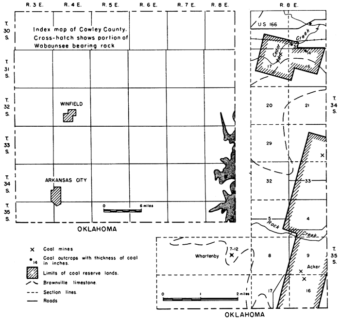
Cedar Creek coal
Coal has been mined in Cowley County at three localities. There are three drift mines in the west-facing bluffs of Cedar Creek in the NE sec. 17, T. 34 S., R. 8 E., about 2.25 miles west and 0.25 to 0.5 mile south of Cedar Vale and 0.25 mile south of the east-west section line road. According to W. J. Hestland, who lives in the SE cor. sec. 8, approximately 0.25 mile east of the mines, the coal is 18 inches thick and was mined as recently as 1937 or 1938. Mining started at this locality between 40 and 50 years ago. The coal at that time was hauled to Arkansas City and Cedar Vale. The same coal was mined in the extreme southeast corner of the county within a mile of the Kansas-Oklahoma state line where it was stripped along a small north-flowing stream on the D. H. Acker farm in the SW sec. 9, T. 35 S., R. 8 E., and on the farm adjoining on the south in sec. 16. According to Mr. Acker the coal was 14 to 16 inches thick and was overlain by 8 feet of shale and soil. The coal was mined 50 or more years ago and hauled to Cedar Vale, High Prairie, Dexter, and Otto. The coal occurs in the basal part of the Willard shale a few feet above the upper Elmont limestone bed (Figs. 2, 19). In the SE cor. sec. 28, T. 34 S., R. 8 E., along the Cowley-Chautauqua County line, a low dump heap containing fragments of coal marks the location of a former shaft mine. The coal lies about 20 feet beneath the surface and is believed to be the equivalent of the coal stripped on the Acker farm 3 miles south.
Figure 19--Stratigraphic section of strata in the southeastern comer of Cowley County, Kansas, showing coal beds and their relation to adjacent rocks.
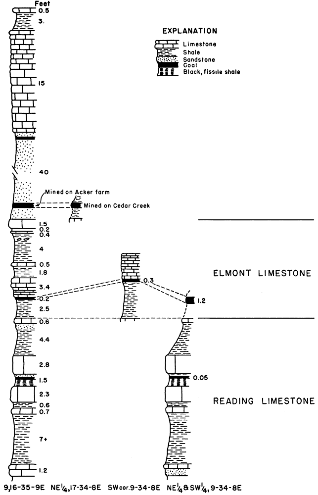
The coal under consideration has not previously been discussed and stratigraphically defined. A comparative study by J. M. Jewett and me of the stratigraphy along Cedar Creek and at the Acker locality has demonstrated that the coal at the two localities is the same and that it occurs a few feet above the top of the Elmont limestone in the basal part of the Willard shale formation. The name "Cedar Creek coal" is assigned to it for purposes of discussion.
Unnamed coal
In the SW cor. sec. 9, T. 34 S., R. 8 E., about 0.3 mile east and 0.3 mile north of the three Cedar Creek drift mines in sec. 17 previously discussed, a 2- to 3-inch coal crops out in the north bank of Cedar Creek. The coal also crops out at the terrace along the north section line road of sec. 16 about 0.6 mile east where it is 14 inches thick. Because of the proximity of this coal to the Cedar Creek drift mines, it was thought that the coals at the two localities were the same. Study of the stratigraphic sequence of the rocks in the Acker locality 6 to 7 miles farther south and comparison with the rock section along Cedar Creek, however, disclosed that the coal exposed along Cedar Creek in sec. 9 and along the road in sec. 16 is stratigraphically below the coal mined at the three drift mines in sec. 17, T. 34 S., R. 8 E., and at the Acker strip mines in secs. 9 and 16, T. 35 S., R. 8 E. The coal occurs in the Harveyville shale between the Elmont and Reading limestone formations and is approximately .13 feet below the Cedar Creek coal in the Willard shale formation,(Fig. 19). This coal, like the Cedar Creek coal, has not been discussed previously nor named. Coal 7 to 12 inches thick is also reported by C. T. Whartenby (personal communication) - to have been mined on his ranch in the east part of sec. 7, T. 35 S., R. 8 E. Search for the coal and mines, however, was unsuccessful.
Table 19--Location and classification by type of mine of coal mines in Cowley County, Kansas
| Location | Number of mines | |||
|---|---|---|---|---|
| Shaft | Drift | Strip | Total | |
| NE sec. 17-34-8E | 3 | 3 | ||
| SE cor. sec. 28-34-8E | 1 | 1 | ||
| SW sec. 9-35-8E | 1 | 1 | ||
| NW sec. 16-35-8E | 1 | 1 | ||
| Total | 1 | 3 | 2 | 6 |
Production and reserves
Although local residents report that much coal has been mined at the Cedar Creek drift mines and in the southeast corner of the county, no production has been recorded with the state coal mine inspectors; hence no definite tonnage can be given. It is doubtful whether more than 10,000 tons of coal, 5,000 tons at each one of the two mining localities, have been mined in the six coal mines (Table 19) in southeastern Cowley County. The proved Cedar, Creek coal reserve lands include 1 square mile in secs. 16 and 17, T. 34 S., R. 8 E., which is underlain by 18-inch coal, and 4 square miles in secs. 28 and 33, T. 34 S., R. 8 E. and secs. 4, 8, 9, 16, and 17, T. 35 S., R. 8 E., underlain by 15-inch coal. Of the unnamed 14-inch coal in sec. 16, T. 34 S., R. 8 E., there is a proved reserve of 0.5 square mile and 560,000 tons of coal. The total proved reserve coal is approximately 6,790,000 tons. The potential reserve lands and tonnage of the Cedar Creek coal are 150 square miles and 191,990,000 tons of coal. Because of the rapid thinning of the unnamed coal from 14 to 2 inches within half a mile, no potential coal reserve area and tonnage of this coal are presented (Table 20).
Table 20--Proved and potential Wabaunsee coal reserve lands and tonnage in Cowley County, Kansas.
| Coal bed |
Location | Proved reserves | Potential reserves | ||||
|---|---|---|---|---|---|---|---|
| Average thickness of coal, inches |
Sq. miles |
Tons | Average thickness of coal, inches |
Sq. miles |
Tons | ||
| Cedar Creek | 16, 17-34-8E | 18 | 1 | 1,435,000 | |||
| 28, 33-34-8E | 16 | 150 | 191,990,000 | ||||
| 4, 8, 9, 16, 17-35-8E |
15 | 4 | 4,795,000 | ||||
| Unnamed | 16-34-8E | 14 | 0.5 | 560,000 | |||
| Total | 6,790,000 | 191,990,000 | |||||
Doniphan County
The only coal in the Wabaunsee group that crops out in Doniphan County is the Nodaway. The Wabaunsee rocks, from the Howard to the Reading formations, inclusive, are essentially confined to the westermost tier of R. 19 E. with an extension into R. 20 E. in Ts. 3 and 4 S. (Fig. 20).
Figure 20--Map of Doniphan County, Kansas, showing outcrops of the Nodaway coal and trace of the Howard Limestcne.
Nodaway coal
Outcrops of the Nodaway coal and of the overlying Howard limestone formation are scarce, largely because of the heavy glacial drift covering this part of the state. The Bachelor Creek limestone member of the Howard limestone formation is absent; thus the coal is overlain and underlain by shale, which aids in concealing the coal. Where the coal can be seen it lies 1 foot 2 inches to 2 feet 6 inches below the Church limestone, which consists of a single massive bed 17 to 20 inches thick. The coal was observed at five places. In the NW cor. SW sec. 28, T. 3 S., R. 19 E., 1 1/2 miles south and 1 mile east of Leona, the coal is split into two units by a 6-inch shale; the upper unit is 2 inches thick and the lower 4 inches. At the other four localities the coal consists of a single bed 5 to 12 inches thick. At the Van Roussen farm, in the NW cor. sec. 34, T. 4 S., R. 19 E., 2 1/2 miles east and 1 mile south of Purcell, the Utopia or uppermost member of the Howard limestone formation is missing. Beneath the coal, which is 12 inches thick, is a gray shale. In the NW cor. SW sec. 34, T. 4 S., R. 19 E., the coal which is 9 inches thick, is underlain by a 9-inch ash-colored underclay and overlain by glacial till. The present exposure is due to recent undermining of the supports of a small county road bridge which when repaired will again conceal the coal. The 9-inch thickness of the coal does not necessarily represent the entire thickness as is suggested by the 12-inch seam 0.5 mile farther north.
The occurrence of the Nodaway coal in Doniphan County had been noted by Swallow (1866, p. 105) before 1866. Mudge, who had also seen the coal, reported (1866, p. 18) that the coal had been mined at various places in Doniphan and Brown Counties. Mudge (1875, p. 125) also states that the coal, at that time not recognized as the same vein that was mined near Osage City in Osage County, had been worked by stripping in various counties including Doniphan. Condra (1927, p. 103) reports the presence of an abandoned coal mine at the railroad level about 0.4 mile west of White Cloud. Search for this mine in the SW sec. 9, T. 1 S., R. 19 E., was unsuccessful largely because of the great amount of slumping that has taken place and the change in the road level since the abandonment of the railroad some years ago. If coal was mined at this locality, it probably was not less than 12 inches thick.
Production and reserves
It is not known how much coal was mined just west of White Cloud or anywhere else in Doniphan County, but the tonnage probably is insignificant. On the basis of coal outcrops, it is calculated that there are 1.9 square miles of proved coal reserve lands in secs. 21, 22, 27, 28, 33, and 34, T. 4 S., R. 19 E., underlain by 1,820,000 tons of 12-inch coal (Table 21). In addition there are 2.7 square miles of 10-inch proved reserve lands south of Denton capable of yielding 2,160,000 tons of coal. The total proved reserve coal tonnage for Doniphan County is 3,980,000 tons. Although coal has been mined just west of White Cloud (Condra, 1927, p. 103), no proved coal reserves are listed for this locality. The coal is at least 100 feet beneath the surface, which is too deep for economical stripping or shaft mining of a 12-inch seam. Limited drift mining, however, could be carried on. Potentially there are 47,280,000 tons of coal reserves underlying 51 square miles in Doniphan County.
Table 21--Proved and potential Nodaway coal reserve lands and tonnage in Doniphan County, Kansas
| Location | Proved reserves | Potential reserves | ||||
|---|---|---|---|---|---|---|
| Average thickness of coal, inches |
Sq. miles |
Tons | Average thickness of coal, inches |
Sq. miles |
Tons | |
| Secs. 21, 22, 27, 28, 33, 34-4-19E |
12 | 1.9 | 1,820,000 | 11 | 21 | 18,480,000 |
| Secs. 3, 10, 11, 15, 16, 22-4-19E |
10 | 2.7 | 2,160,000 | |||
| Secs. 8, 9, 16-1-19E |
12 | 30 | 28,800,000 | |||
| Total | 4.6 | 3,980,000 | 51 | 47,280,000 | ||
Elk County
The Wabaunsee group of rocks crops out in the western half of Elk County (Fig. 21). Coal occurs at several horizons, but as far as known only the Nodaway and Elmo coals have been mined. As early as 1877 coal from this county was used for local domestic purposes (Gray, 1878, p. 201). Production in the county, however, has not been great.
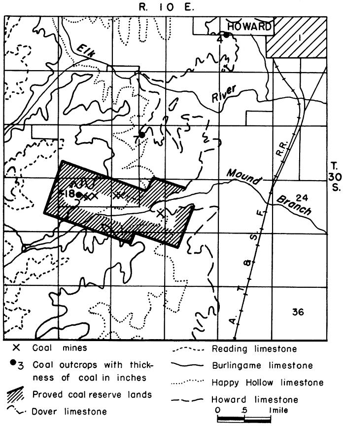
Figure 21--Map of Elk County, Kansas, showing the Wabaunsee coal-bearing strata, coal mines, and traces of the Howard and Brownville limestones.
Nodaway coal
Nodaway coal crops out at a number of places along the edges of the Howard limestone escarpment, but nowhere has the thickness of the coal been more than 7 inches. North of Howard, in sec. 11, T. 29 S., R. 10 E., the coal is 4 to 5 inches thick; 1 mile west of the city, in sec. 2, T. 30 S., R. 10 E., it is only 4 inches thick; and in sec. 16, T. 30 S., R. 10 E., about 2.5 miles west and 1.5 miles south of Howard, it is again 7 inches thick. In the SE sec. 21, T. 30 S., R. 10 E., the coal was found close to creek level but because of high water and slump its thickness could not be measured. As far as I could determine from the general descriptions given in the reports of the state coal mine inspectors and by Whitla (1940, p. 36), coal was formerly mined at this locality. According to Whitla (1940, p. 36) the coal is 18 inches thick. The mine, a slope mine, was abandoned in 1899 after a cave-in killed a man. South of Moline, in the NE cor. sec. 21 and at the SW cor. NW sec. 33, T. 31 S., R. 10 E., the Nodaway coal is only 1 inch thick. Even though the coal is less than 12 inches thick attempts to mine it are evident. In secs. 11 and 12, T. 29 S., R. 10 E., 4.5 miles north of Howard there are several shallow pits from which coal has been taken. Less than 100 to 500 feet from these pits the coal is exposed in the bed of a small creek and is only 4 inches thick. The Nodaway coal occurs between the Bachelor Creek limestone and a thin limestone bed 4 to 5 inches thick underlying the typical massive well-jointed Church limestone, from which it is separated by about 1 foot of black fissile and gray shale. The five stratigraphic sections on Figure 4 show the typical sequence and variations of the Howard limestone members and associated Nodaway coal in Elk County.
Elmo Coal
In the NW sec. 21 and N2 sec. 20, T. 30 S., R. 10 E., southwest of Howard, are the remnants of long-abandoned strip mines. The main mines are on the Will Neigh farm (formerly occupied by Jenks and Jaggards) in the N2 sec. 20. Coal was last mined from two strip pits and one shaft mine at this locality in 1922. By a little digging I was able to find the coal, which ranges from 16 to 18 inches in thickness. A grayish-blue shale overlies the coal. Mr. Neigh reported that beneath the coal is 4 feet of underclay. The coal is the Elmo coal, not the Nodaway coal as previously reported by Whitla (1940, pp. 36-37). The Nodaway coal occurs at least 1 mile east or downstream from the nearest strip mine (Fig. 22).
Figure 22--Map of the Howard coal mining district, Elk County, Kansas, showing location of Nodaway and Elmo coal mines, proved coal reserve lands, and traces of the Howard, Happy Hollow, Burlingame, Reading, and Dover limestones.
Production
There are at least six coal mines in Elk County in addition to the small pits from which coal was taken north of Howard in secs. 11 and 12, T. 29 S., R. 10 E. (Table 22). The first recorded production of coal in Elk County is for 1894 when 800 tons were reported. For the following year Elk County is credited with 1,560 tons, which is probably in error if the location of the mine cited by the state coal mine inspector is correct. According to his report (Brown, 1896, p. 65) the mine was 13 miles southeast of Grenola. Since Grenola is only 3 miles north of the Elk-Chautauqua County line, the mine undoubtedly is in Chautauqua County and probably in the Leeds mining district. According to published data, the cumulative coal production for Elk County totals 3,615 tons not counting the 1895 tonnage (Table 23). As elsewhere, more coal has been mined than the published records show and it is not unlikely that the total cumulative production is close to 10,000 tons.
Table 22--Location and classification by type of mine of coal mines in Elk County, Kansas
| Location | Number of mines | |||
|---|---|---|---|---|
| Shaft | Drift | Slope | Total | |
| NE cor. SE sec. 11-29-10E | 2 | 2 | ||
| SW cor. SW sec. 12-29-10E | 3 | 3 | ||
| SE sec. 21-30-10E | 1 | 1 | ||
| NW sec. 21-30-10E | 2 | 2 | ||
| N2 sec. 20-30-10E | 1 | 2 | 3 | |
| Totals | 1 | 1 | 9 | 11 |
Table 23--Published coal production data for Elk County, Kansas.
| Year | Tons |
|---|---|
| 1894 | 800 |
| 1896 | 1,500 |
| 1897 | 320 |
| 1898 | 75 |
| 1899 | 120 |
| 1901-02 | 800 |
| Total | 3,615 |
Reserves
Elk County contains approximately 544 acres or 0.85 square mile of proved Nodaway reserve coal lands underlain by an 18-inch coal. This acreage contains 1,220,000 tons of proved coal reserve. The potential Nodaway coal reserve area consists of 50 square miles containing 72,020,000 tons of coal. The proved reserve coal lands underlain by Elmo coal 18 inches thick include 986 acres or 1.4 square miles and contain 2,020,000 tons of coal. The potential Elmo reserve coal area and tonnage amount to 180 square miles and 259,220,000 tons. Elk County has a total proved coal reserve of 3,240 tons and a potential reserve of 331,240,000 tons (Table 24).
Table 24--Proved and potential Wabaunsee group reserve coal lands and tonnage in Elk County, Kansas.
| Coal bed |
Location | Proved reserves | Potential reserves | ||||
|---|---|---|---|---|---|---|---|
| Average thickness of coal, inches |
Sq. miles |
Tons | Average thickness of coal, inches |
Sq. miles |
Tons | ||
| Nodaway | Secs. 21, 22-30-10E | 18 | 0.85 | 1,220,000, | 18 | 50 | 72,020,000 |
| Elmo | Secs. 16, 17, 20, 21-30-10E |
18 | 1.4 | 2,020,000 | 18 | 180 | 259,220,000 |
| Total | 3,240,000 | 331,240,000 | |||||
Greenwood County
Greenwood County is traversed centrally from north to south by a strip of Wabaunsee coal-bearing rocks averaging 9 miles in width (Fig. 23). Nodaway, Elmo, and Lorton coals are known to crop out in the county. The occurrence of coal in Greenwood County was noted by Swallow in 1866 (p. 56). Likewise Hawn (Swallow, 1866, p. 113) refers to the outcropping of several beds of coal in the Verdigris Valley, especially on Wilhites Creek in sec. 18, T. 24 S., R. 13 E. near Verdigris Falls and at the mouth of Rock Creek near the northern boundary of the county. The coal at the former locality does not belong in the Wabaunsee group as the rocks in that part of the Verdigris Valley are stratigraphically lower than the Severy shale which marks the base of the Wabaunsee group. In 1875 and before, some coal found at a depth of 4 to 8 feet was used for blacksmithing, as fuel for steam mills, and to a limited extent for domestic purposes (Gray, 1875, p. 279). In 1890 (Mohler, 1891, p. 98) preparations were being made in the northwestern part of the county to work a vein of coal which was reported to be 37 inches thick and to lie 26 feet below the surface. Subsequent reports carry no references to the actual mining of this coal; it is inferred, therefore, that the venture was unsuccessful and that most likely the thickness of the coal was grossly exaggerated. That coal was actually mined to a limited extent is indicated by Crane (1898, pp. 128-129) who states: "There is a line of strip pits on the eastern side of the Santa Fe Railway extending both to the northeast and southwest of Eureka, reaching Elk County on the south and Lyon County and Coffey County on the north." It is probably these same mines that Adams, Girty, and White (1903, p. 51) had in mind in referring to some small mines in Greenwood County in which the coal, they thought, probably came from the same horizon as that mined in the vicinity of Silver Lake, west of Topeka, in Shawnee County.
Figure 23--Map of Greenwood County, Kansas, showing location of coal mines and outcrops and traces of the Howard, Burlingame, and Brownville limestones. [A larger Acrobat PDF version of this figure is available.]
Nodaway coal
From field observations and in the absence of any published data on coal production it seems certain that there has been no commercial coal mining of any significance in Greenwood County. The Nodaway coal crops out at numerous places along the edge of the Howard limestone escarpment but it is not of minable thickness at any place where seen. The common thicknesses of the coal observed in the field are 2, 3, 4, 7, and 8 inches. The line of strip pits referred to by Crane (1898, pp. 128-129) on the east side of the Santa Fe Railway extending northeast of Eureka to Lyon County must be in Nodaway coal territory. No evidence of them can be found now, undoubtedly because the strip pits were extremely local, small, and scattered owing to the thinness of the coal. Only one mine worked for local use was reported to me. This mine is in approximately the Cen. sec. 3, T. 22 S., R. 12 E. The coal near by is only 4 inches thick.
Lorton coal
Lorton coal crops out in the NW cor. sec. 12, T. 22 S., R. 10 E., 1 mile south of the Greenwood-Lyon County line in the northwest township of the county. The coal, 11 inches thick, contains a clay parting 1 inch thick 1 inch above the base of the coal. According to an old resident living about 1 mile north of the coal outcrop, coal was mined here 50 or 60 years ago by drifting. The drift extended about 100 feet into the hillside. This mine may possibly be the one referred to by Mohler in 1891 in which the coal was supposed to have had a thickness of 37 inches.
Production and reserves
Production of coal in Greenwood County is negligible. There are no proved reserve coal lands in the county and only 70 square miles of potential reserve coal lands containing Lorton coal. The potential reserve area contains 61,600,000 tons of 10-inch coal. Some of the Lorton coal in the NW cor. sec. 12, T. 22 S., R. 10 E. could be mined by drifting at the present time.
Jackson County
Wabaunsee coal-bearing rocks crop out in the eastern part of Jackson County east of a north-south line drawn through Holton and in parts of Ts. 8 and 9 S., Rs. 13 and 14 E. (Fig. 24).
Figure 24--Maps of Jackson County, Kansas, and the Larkinburg mining district, showing location of coal mines and outcrops, proved coal reserve lands, and traces of the Burlingame, Reading, and Brownville limestones.
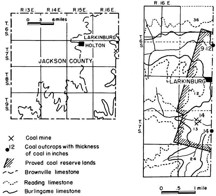
Elmo coal
Very little coal has been mined in Jackson County. Only 3 drift mines were located. They are in the NE near the Cen. sec. 12, T. 7 S., R. 16 E., about 1.5 miles south and 0.5 mile west of Larkinburg. This coal, the Elmo, is 14 inches thick and crops out in the same north-facing bluff into which the mines have been drifted. The Coleman mines in Atchison County (p. 59) are approximately 0.5 mile to the east. Crane (1898, p. 129) reported the occurrence of mines in the extreme southeastern part of the county along Muddy and Cedar Creeks, but these mines were of little importance. I did not see these mines.
Reserves
No production figures for the three drift mines near Larkinburg are available. There are 2.5 square miles of proved reserve coal lands in Jackson County, underlain by 14-inch coal. These lands contain 2,800,000 tons of Elmo coal. The potential reserve coal area is 200 square miles containing approximately 191,500,000 tons of coal which averages 12 inches in thickness (Table 11).
Jefferson County
Rocks of the Wabaunsee group crop out in the northern and western tier of townships covering almost half the area of Jefferson County (Fig. 25). Two coals, Nodaway and Elmo, are present, but only the Nodaway has been mined.
Figure 25--Map of Jefferson County, Kansas, showing location of coal mines and outcrops, proved coal reserve lands, and traces of the Howard and Burlingame limestones. [A larger Acrobat PDF version of this figure is available.]
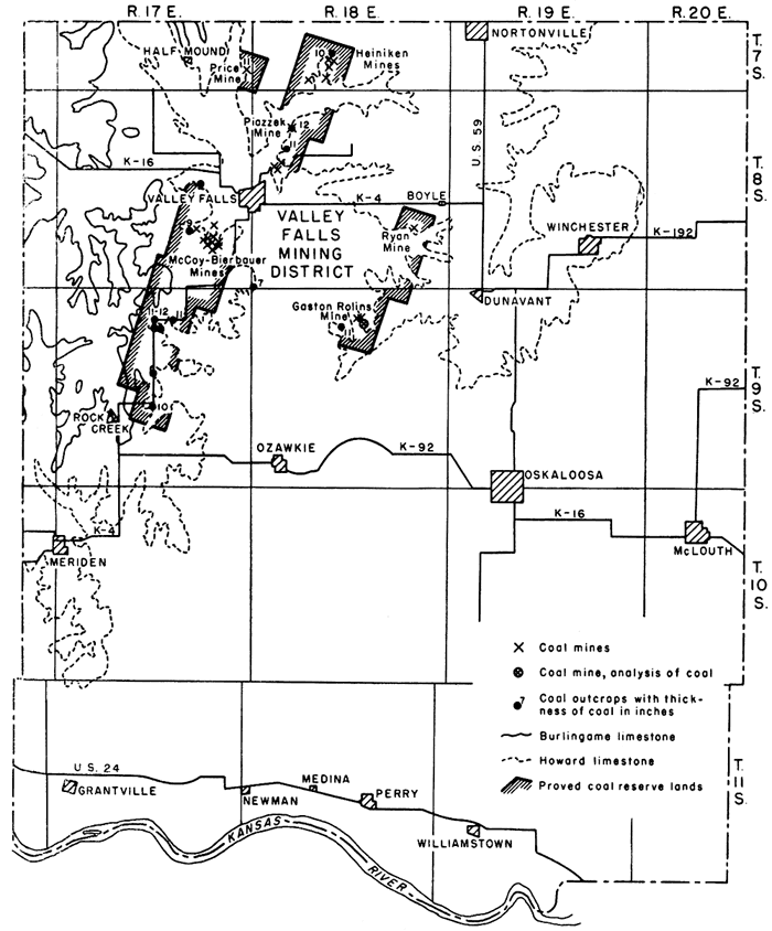
Nodaway coal
All the outcrops and mines of the Nodaway coal follow closely the outcrop of the Church limestone of the Howard limestone formation. Throughout the area of outcrop the coal maintains a fairly uniform thickness, ranging from 9 to 14 inches with much of the coal 1 foot thick. The coal occurs as a single bed and lies close to the overlying Church limestone from which it is separated by a light to dark partly fissile shale. The shale is 1 foot 3 inches to 3 feet 4 inches thick, averaging 2 feet 4 inches at most outcrops. The Church limestone, the stratigraphic marker for the coal, at most places occurs as a single massive well-jointed bed of blue to bluish-gray fossiliferous rocks, which on weathering turn yellowish to deep rich brown. At a number of places the massive bed is overlain by a 4- to 7-inch limestone, and in the road bank outcrop on Kansas Highway 4, at the SW cor. SE sec. 3, T. 9 S., R. 17 E., four 3-inch beds are present above the massive bed. In Jefferson County the Church limestone ranges from 1 foot 6 inches to 2 feet 5 inches in thickness, the average being about 2 feet. Immediately underlying the coal is a sticky structureless ash-gray to bluish clay averaging 1 foot in thickness. Beneath this underclay is a bluish-gray shale which at places is sandy. The Bachelor Creek limestone, lowermost member of the Howard limestone formation, is missing in Jefferson County. Shale and the Utopia limestone overlie the Church limestone. The Utopia limestone is composed of several units of limestone and interbedded dark shales similar to those in Osage County. Sections showing stratigraphic relations of the coal to overlying and underlying rocks are presented in Figure 3. Proximate analyses of the coal are given in Table 3.
Twenty-eight Nodaway coal mines (Table 25) have been in operation at one time or another in Jefferson County. All were drift or slope mines with the exception of two shaft mines. It is also reported that a strip mine formerly existed along Grasshopper or Delaware Creek in sec. 34, T. 7 S., R. 17 E., 0.5 mile south of Half Mound. The mines, now abandoned and for the most part caved in, follow the edge of the Howard limestone escarpment. According to one resident, coal mining in the county started in 1856 and practically ceased following the depression years of World War I. It is definitely known that coal. was mined by stripping in 1875 (Mudge, 1875, p. 125), According to Whitla (1940, p. 41) the mining of Nodaway coal in an area 1 mile south of Valley Falls started in 1924, and in 1939 one mine was still being operated to supply fuel for the owner. A drift mine was opened late, in the fall of 1943 on the Gaston Rolins farm in the NW sec. 10, T. 9 S., R. 18 E., 3.5 miles west and 0.75 mile south of Dunavant. At the time of my visit on September 26, 1944, the tunnel had been extended 25 feet into the hill and was 7 feet high and 10 feet wide. The coal, 14 inches thick, lies 3 feet beneath the Church limestone. Beneath the coal is an underclay. The overburden is approximately 25 to 30 feet, so that considerable coal could be mined here by the stripping method. A proximate analysis of this coal, which compares favorably with other Nodaway coals, is presented in Table 3. Perhaps the largest mine, now abandoned, in Jefferson County is less than 0.25 mile north and 0.25 mile west of the Gaston Rolins drift mine just described. This mine, formerly operated by Rolins, is in a small ravine in the SW sec. 3, T. 9 S., R. 18 E. Much coal must have been removed from this mine judging from the size of the dump heap, trackage, and coal cars scattered about. Coal was also mined in the SW cor. NE sec. 36, T. 7 S., R. 17 E. Several abandoned drift mines are found along the west-facing bluff of a small stream on the Heiniken farm, in the NW sec. 33, T. 7 S., R. 18 E., and farther south in the SW of the same section.
Table 25--Location and classification by type of mine of Nodaway coal mines in Jefferson County, Kansas.
| Location | Farm | Number of mines | ||
|---|---|---|---|---|
| Shaft | Drift | Total | ||
| Cen. 36-7-17E | Price farm | 1 | 1 | |
| SE 14-8-17E | 1 | 1 | ||
| SE 32-7-18E | 1 | 1 | ||
| NW 33-7-18E | Heiniken farm | 3 | 3 | |
| SW 33-7-18E | 1 | 1 | ||
| NE 18-8-18E | 1 | 4 | 5 | |
| SW 18-8-18E | 2 | 2 | ||
| NW 26-8-17E | 1 | 1 | ||
| NE 26-8-17E | 1 | 1 | ||
| SE 26-8-17E | McCoy-Bierbauer | 8 | 8 | |
| NE 26-8-18E | Ryan farm | 1 | 1 | |
| SW 3-9-18E | Rolins farm | 2 | 2 | |
| NW 10-9-18E | Rolins farm | 1 | 1 | |
| Totals | 2 | 26 | 28 | |
Several drift mines and a shaft mine were formerly operated about 1 mile northeast of Valley Falls in the E2 sec. 18, T. 8 S., R. 18 E. An exposure in the road cut just south of the mines shows that the coal is 13 inches thick. Some coal was mined south of Valley Falls on the McCoy farm in the NE cor. SE sec. 26, T. 8 S., R. 18 E., and also 0.5 mile north in the NE cor. NE of the same section. According to Whitla (1940, p. 41), the haulageway of the mine at the latter locality is 4 feet wide and reaches from a layer 15 to 18 inches below the coal to the limestone 29 inches above it. The room in which the miners worked was 24 feet wide. The coal was 8 to 9 inches thick and contained clay seams and pyrite. The mine was worked last in 1939. At the McCoy mine near the barn the coal is 9 to 11 inches thick and is 25 inches below the Church limestone. Several coal cars were seen on the dump heap. The mines were operated by Mr. Bierbauer who lives close to them. According to him the 8 mines on the place were operated from 1923 to 1941. The coal averaged 10.5 inches in thickness and sold at first for $6.50 per ton; 12 to 15 miners were employed. The room and pillar method of mining was used, and the rooms measured 20 by 100 feet. The longest tunnel extended 500 to 600 feet from the mine portal. At no place was the mine more than 25 feet below the surface. Coal was also mined in the NW cor. NE NW of the same section. On the Stephan Ryan farm 4.5 miles east and 0.75 mile south of Boyle Station, in the NE sec. 26, T. 8 S., R. 18 E., is an abandoned shaft mine. This mine is reported to have had a 12-inch coal seam and to have furnished coal for local trade,. It was in operation in 1902 (Casselman, 1903, p. 20).
Production
Published statistical data on the amount of Nodaway coal mined in Jefferson County are very scarce. Although it is known that coal was dug as early as 1856, the earliest production record is for 1875 (Gray, p. 294) when 2,000 tons, sold at $4.00 per ton, were produced. According to Mudge (1875, p. 125), the coal was mined by stripping. According to published records a cumulative total of 6,110 tons of coal has been mined in Jefferson County (Table 26). A reasonable estimate of the amount of coal produced from the 28 known mines or that taken during the 78 years for which no published records are available probably would not exceed 40,000 tons. In addition, coal was undoubtedly taken directly from the face of outcrops by farmers on whose land the coal crops out. The amount thus taken is quantitatively unimportant and not subject to estimation.
Table 26--Published coal production data for Jefferson County, Kansas.
| Year | Tons |
|---|---|
| 1875 | 2,000 |
| 1878 | 280 |
| 1928 | 1,120 |
| 1929 | 1,500 |
| 1930 | 500 |
| 1931 | 250 |
| 1934 | 460 |
| Total | 6,110 |
Reserves
The Nodaway coal in Jefferson County is fairly uniform in thickness throughout the county wherever observed. Considering 11 inches as the average thickness of the coal there are in the 15.5 square miles of proved coal reserve lands in the county (Table 27) 13,600,000 tons of proved coal reserve. The potential Nodaway coal reserve area includes 150 square miles containing 132,000,000 tons of 11-inch coal.
Table 27--Proved and potential Nodaway coal reserve lands and tonnage in Jefferson County, Kansas. [Average thickness of coal, 11 inches.]
| Location | Proved reserves | Potential reserves | ||||
|---|---|---|---|---|---|---|
| Sq. miles |
Tons | Sq. miles |
Tons | |||
| secs. 25, 36 | 7-17E | Price farm | 0.7 | 620,000 | ||
| sec. 31 | 7-18E | |||||
| secs. 28, 29, 32, 33 | 7-18E | Heiniken farm | 1.8 | 1,580,000 | ||
| sec. 5 | 8-18E | |||||
| secs. 4, 5, 8, 9, 17, 18 | 8-18E | NE Valley Fails | 0.8 | 700,000 | ||
| secs. 14, 22, 23, 25, 26, 27, 34, 35, 36 |
8-17E | McCoy-Bierbauer | 9.6 | 8,450,000 | 150 | 132,000,000 |
| secs. 2, 3, 4, 9, 10, 15, 16, 21, 22, 27, 28 |
9-17E | Rock Creek | ||||
| secs. 23, 24, 25, 26, 34,35,36 |
8-18E | Ryan farm | 2.6 | 2,290,000 | ||
| secs. 2, 3, 4, 9, 10 | 9-18E | Rolins farm | ||||
| Total | 15.5 | 13,640,000 | 150 | 132,000,000 | ||
| Production | 40,000 | |||||
| Reserves | 15.5 | 13,600,000 | 150 | 132,000,000 | ||
Prev Page--Production, Reserves || Next Page--More on Counties
Kansas Geological Survey, Geology
Placed on web Jan. 27, 2013; originally published December 1946.
Comments to webadmin@kgs.ku.edu
The URL for this page is http://www.kgs.ku.edu/Publications/Bulletins/63/06_county.html