![]()
Prev Page--Stratigraphy--Cambrian || Next Page--Stratigraphy--Silurian
Stratigraphy, continued
Rocks of Ordovician Age
Van Buren Formation
The Van Buren formation is the oldest Ordovician formation recognized in Missouri. The base of the Van Buren is marked by a basal sandstone member, the Gunter sandstone, which is described by McQueen (1931) as composed of fine- to medium-rounded and frosted sand grains. The Van Buren was originally included in the Gasconade dolomite, from which it was separated by Ulrich and Bridge on faunal grounds and differentiated by McQueen on the basis of insoluble residues.
The Van Buren formation in southeastern Missouri consists of dark bluish-gray, finely crystalline but locally granular dolomite. the chert is described as white, dense, porcelain-like, and oolitic. McQueen (1931, p. 18) distinguishes the Van Buren from the underlying Proctor dolomite by the absence of chert in the Proctor and from the overlying Gasconade by the darker color of the Gasconade chert and by the character and distribution of the dolocasts in the chert of the insoluble residues.
In northeastern Kansas, the Van Buren dolomite has not been differentiated from the Gasconade in cuttings from wells although a sandstone corresponding to the Gunter sandstone has been recognized.
The Van Buren has a thickness of 35 to 235 feet in Missouri but if present is probably thin in northeastern Kansas. The Gunter sandstone member at the base of the Van Buren is 12 feet thick in the Greenwood well, Jackson County, Missouri, and 6 feet thick in the Duffens et al. No. 1. Stanley well, in sec. 3, T. 14 S., R. 21 E. Sandy dolomite 10 feet thick occurs immediately above the Eminence in the Forrester et al. No. 1 Hummer well, in sec. 14, T. 11 S., R. 16 E., but it is possible that it represents basal Gasconade instead of basal Van Buren dolomite.
During the time represented by the unconformity at the base of the Van Buren formation, the central part of the basin was again depressed and the marginal areas raised and eroded. The Proctor was eroded from the marginal areas and the Eminence exposed. Upon this surface the Van Buren formation was deposited, and it thus overlies the Proctor unconformably in central Missouri and overlaps unconformably upon the eroded surface of the Eminence in northeastern Kansas. The Van Buren has not been identified in northeastern Kansas.
Gasconade Dolomite
The Gasconade dolomite crops out in the lower part of most of the valleys of the central Ozarks. McQueen (1931) reports that there is an unconformity between the Gasconade and Van Buren formations and that well samples from the base of the Gasconade contain siliceous oolite accompanied in some localities by small amounts of sand. The Gasconade consists of light-colored finely crystalline dolomite characterized by the dark-blue color of the hard vitreous to quartzose chert.
The strata between the Eminence and the Roubidoux have not been satisfactorily differentiated in Kansas; they would all be referred to the Gasconade on the basis of lithologic characteristics if it were not for the presence of sandstone corresponding to the Gunter at the base.
The Gasconade has a reported thickness of 140 to 200 feet in Missouri. The thickness of the undifferentiated Van Buren formation and the Gasconade dolomite in the Greenwood well, in sec. 27, T. 47 N., R. 31 W., Jackson County, Missouri, is 192 feet. It is 206 feet thick in the Duffens No. 1 Stanley well, in sec 3, T. 14 S., R. 21 E., and 90 feet thick in the Forrester No. 1 Hummer well, in sec. 14, T. 11 S., R. 16 E.
The hiatus between the Gasconade and Van Buren formations is perhaps no greater than that represented by many other unconformities within the Cambrian and Ordovician formations of the Ozarks. An unconformity also separates the Gasconade and the overlying Roubidoux formation. The unconformity at the base of the St. Peter bevels the top of the Gasconade northwest of the Hummer well, as shown in figure 5.
Roubidoux Formation
The Roubidoux formation underlies much of the upland area of the central part of the Ozark plateau in Missouri where it is composed of sandstone and cherty dolomite. Thick sandstone beds occur in the outcrops near the top and at the bottom of the formation. Other sandstone beds, some of which are thin and lenticular, and sandy dolomite beds are interstratified with the dolomite within the formation.
The Roubidoux formation in the subsurface of northeastern Kansas consists mainly of dolomite, sandy dolomite, and fine subangular sand. Sandstone is quantitatively subordinate and constitutes less than 10 percent of the formation in some wells. In well cuttings it is difficult to distinguish dolomite of the Roubidoux formation from other dolomites without the aid of insoluble residues. (R. P. Keroher, oral communication).
The Roubidoux formation shows relatively little variation in thickness. It is 135 feet thick in the Greenwood well in Jackson county, Missouri; 167 feet thick in the Stanley well, in sec. 3, T. 14 S., R. 21 E.; and 175 feet thick in the Hummer well, in sec. 14, T. 11 S., R. 16 E. R. P. Keroher reports (oral communication) that in the Hummer well the Roubidoux is unconformably overlain by the St. Peter sandstone.
The formation is reported by McQueen (1931, pl. 3) to be bounded both above and below by inconspicuous unconformities. The stratigraphic relations of this formation are obscure in Kansas and the Roubidoux is one of the most widely distributed formations of Ordovician age. The Roubidoux was beveled by erosion preceding the deposition of the St. Peter (fig. 5) and was probably removed from structurally positive areas.
Jefferson City and Cotter Dolomites
Outcrops of undivided Jefferson City and Cotter dolomites flank the Ozark region of Missouri in an irregular broad belt. Lithologically these formations closely resemble each other and no separation of these formations has been made in northeastern Kansas. At surface outcrops in Missouri, the Jefferson City and Cotter are in part dense to finely crystalline dolomite and in part argillaceous dolomite. Chert is common to both formations, but less abundant in the Jefferson City. These formations are differentiated by McQueen (1931, pp. 121-124) in Missouri by characteristics of their insoluble residues; the Jefferson City is reported to be less cherty and contains less siliceous oolite than is common in the cherts of the Cotter. The criteria for distinguishing the Cotter and Jefferson City have proved difficult of application in areas removed from the Ozarks.
A maximum thickness of 120 feet for the Jefferson City dolomite and 420 feet for the Cotter dolomite in the central Ozarks is reported by McQueen, but both formations become thinner toward the west. The combined thickness of the Jefferson City and the Cotter in northwestern Missouri is generally less than 200 feet. This is due partly to the thinning of the formations toward the northwest but chiefly to the fact that the upper Cotter dolomite, together with the Smithville and Powell formations, was removed by erosion during the interval of deformation and peneplanation that preceded the deposition of the St. Peter sandstone. Undifferentiated Jefferson City and Cotter dolomites are reported by McQueen (1931) to be 210 feet thick in the Greenwood well. Keroher reports that the same unit is only 106 feet thick in the Stanley well and that it is absent in the Hummer well.
The Jefferson City dolomite is separated from the underlying Roubidoux and from the overlying Cotter by inconspicuous unconformities. Both are overlapped unconformably by the St. Peter sandstone (fig. 5).
St. Peter Sandstone
The St. Peter sandstone, named from outcrops at St. Peters Falls near Minneapolis, is exposed in eastern Missouri and at other places in the Mississippi valley, and extends westward beneath the surface for hundreds of miles. The sandstone is composed of unusually pure white sand with a large proportion of well-rounded frosted grains. Thin partings of green shale are present in the upper part in some localities.
Much has been written concerning the stratigraphic position of the St. Peter sandstone and its correlation with Ordovician rocks of other regions. There is, however, a lack of agreement as to its exact age because of the absence of fossils in the formation and the occurrence of unconformities at its top and bottom. Furthermore, the St. Peter sandstone in southeastern Missouri and in Arkansas is underlain by the Everton formation which contains sandstone members that resemble the St. Peter.
The correlative of the St. Peter sandstone in Oklahoma is uncertain because of lithologic changes in the rocks, the presence of unconformities, and the lack of fossils in the St. Peter. Some geologists have proposed that the St. Peter be correlated with some part of the sandy Simpson formation. The St. Peter has been correlated with both the Wilcox sand of drillers and the Burgen sandstone of the outcrops, which closely resemble the St. Peter. It is possible that the true St. Peter is absent in Oklahoma, where, as in parts of Arkansas, the members of the Everton have in some places been mistaken for the St. Peter. The St. Peter sandstone in northeastern Kansas is unconformable above all the older Ordovician formations, and in Washington and Marshall counties it overlaps upon granite. The St. Peter is unconformable below the overlying rocks.
In northeastern Kansas the St. Peter has a surprisingly even thickness, although there are locally a few sharp fluctuations. It has a thickness of 85 feet in Johnson County and thins westward without much variation to about 50 feet in the western part of the Forest City basin. It is 50 feet thick in Doniphan County, the northeastern county of Kansas.
Five hundred to 800 feet of rocks of Smithville, Powell, and upper Cotter age that are present in the Ozark area beneath the Everton formation are absent in northeastern Kansas. Six hundred feet or more of rocks, including, in ascending sequence, the Dutchtown, Joachim, Stones River, and Plattin limestones, were deposited in southeastern Missouri during the hiatus between the top of the St. Peter and the next overlying formations in northeastern Kansas. Because of these facts the regularity of the thickness of the St. Peter sandstone is remarkable. An exceptional thickness of 403 feet of St. Peter sandstone was encountered in northeastern Kansas in the Kasper No. 1 James well, in sec. 8, T. 13 S., R. 25 E., where the St. Peter sandstone and a detrital zone at the base replace all Arbuckle rocks above the top of the Roubidoux. McQueen and Greene (1938, p. 42) attribute the great thickness of the St. Peter in this well to channel filling. The St. Peter is unconformably overlain in most wells by the Decorah shale, but the Plattin limestone has been tentatively identified in wells in the deeper part of the North Kansas basin.
Post-St. Peter and Pre-Maquoketa Formations
The rocks between the top of the St. Peter sandstone and the base of the Maquoketa shale in outcrops in the Mississippi valley constitute an easily recognized lithologic unit composed mainly of limestone and dolomite. Rocks in Oklahoma occupying the interval from the top of the sandy Simpson dolomite to the base of the Sylvan shale were called Viola limestone by Taff (1902). An unconformable upper limestone member, the Fernvale limestone (of Richmond age), and a lower limestone member, the Bromide limestone (of Lowville-Black River age), were later separated as formational units from the original Viola limestone. The name Viola limestone is now restricted to the middle part of the original formation and probably consists of rocks of late Black River and early Trenton age. However, the name Viola has continued in use in the midcontinent area in its original sense by oil men and many geologists.
The interval between the St. Peter sandstone and the Maquoketa shale in southeastern Missouri was at one time supposed to be the equivalent of the Viola of Oklahoma. The uncertainty regarding the identity of the St. Peter sandstone in Oklahoma and the occurrence in Missouri of a thick sequence of limestones, some of which are older than Black River, have made it difficult to correlate the Viola limestone with the Missouri section. The following formations, listed in ascending order, are recognized in southeastern Missouri between the St. Peter sandstone and the Maquoketa shale: Dutchtown formation, Joachim dolomite, Stones River limestone, Plattin limestone, Decorah shale, Kimmswick limestone, and Fernvale limestone. Of these formations, only the Decorah shale (of Missouri) and the Kimmswick limestone correspond in age to the restricted Viola of Oklahoma.
Plattin limestone and Decorah shale
At the type locality in eastern Iowa, the Decorah shale consists of 25 to 30 feet of very calcareous green shale with bands and nodules of limestone. At that locality it overlies the Platteville limestone (of Black River age) and underlies the Galena limestone (of Trenton age). The Decorah shale, as originally denned by Calvin (1906, pp. 97, 98), included a group of alternating calcareous green shales and limestones separating the Platteville limestone (of Black River age in the standard eastern section) from the overlying Galena limestone (of Trenton age), and was presumed to be of Black River age. Kay (1928, p. 16, and 1931, p. 370) subdivided it into three members and redefined their ages; the two uppermost members, Ian and Guttenberg, were reported to be of Trenton age and the lowest member, Spechts Ferry, which is separated from the others by an unconformity, was said to be of Black River age. The Spechts Ferry member at the base of the Decorah is regarded by some paleontologists as an upper member of the Platteville or Plattin.
Allen (1932, pp. 259-269) traced a layer of metabentonite (altered volcanic tuff) in the lower part of the Decorah (of Black River age) from the type locality of the Decorah to southeastern Missouri, where the overlying lower Kimmswick rocks are reported by Ulrich to be of Black River age. If the various paleontologic identifications are accepted, only the lower Spechts Ferry member of the Decorah (of Black River age) can be represented in southeastern Missouri, for McQueen (1939, p. 62) and Ulrich (1939, p. 107) classify also that part of the Kimmswick above the metabentonite Decorah of that area as Black River. The Spechts Ferry shale is reported to be conformable upon the underlying Platteville in Iowa, as is the Decorah of southeastern Missouri upon underlying Plattin. Therefore, it appears that the Kimmswick of Missouri includes beds of Black River age younger than occur at outcrops in Iowa where the Spechts Ferry is reported to be the highest Black River formation. There appears to be no conflict in correlating the Plattin of Missouri with the Platteville of Wisconsin and other areas.
There is a shaly and sandy zone below the Kimmswick limestone in most wells drilled in northeastern Kansas, but paleontologic discrimination is impossible from well samples. The term Decorah shale as used herein is applied to a shaly and slightly sandy zone underlying the Kimmswick with seeming conformity and unconformably overlying the St. Peter sandstone.
The Decorah shale of the Forest City basin is characteristically a sandy dolomite interstratified with dark and gray-green shale. It includes, however, gray sublithographic limestone with some shale in Pottawatomie and Riley counties and in the Arab No. 1 Ogle well in Nebraska. Rocks believed to be of Decorah age in some wells in Johnson County, Kansas, and adjoining counties also consist in part or entirely of gray lithographic limestone and shale. Elsewhere in northeastern Kansas the Decorah is composed of brown to buff crystalline dolomite interstratified with dark to dark-gray clay or very dark-green clay in which microscopic pyrite crystals are disseminated. Some of the clay encloses disseminated frosted sand grains and grades vertically into argillaceous sandstone. Black to cinnamon-brown clay shale is widely present near the base of the formation. Opaque black and brown chert occurs at or near the base of the formation in Shawnee, Douglas and adjoining counties. Some of the sand grains in the Decorah are subangular and show secondary growth, but there is also much well-rounded and frosted sand. It is similar to that in the St. Peter, but nearly everywhere less coarse. The sand disseminated in the dolomite becomes increasingly abundant toward the base, although the increase is irregular. In the Turner No. 1 Umschied well, in sec. 32, T. 8 S., R. 9 E., in the deeper part of the North Kansas basin in Pottawatomie County, a sandstone 25 feet thick either in the base of or below the Decorah is separated from the St. Peter sandstone by 20 feet of dolomite and limestone. In the Arab No. 1 Ogle well, in sec. 9, T. 1 N., R. 14 E., Nebraska, this dolomite directly underlies the Decorah shale and overlies the St. Peter sandstone. In this locality the dolomite bed has generally beep correlated with the Plattin limestone, but the occurrence of sandstone above the dolomite in the Turner-Umchied well and in other wells in the Salina basin casts some doubt on this correlation. An unconformity has been reported in Iowa between the upper and lower parts of the Decorah, but no sandstone has been reported in the outcrops nor in the subsurface within or at the base of the Decorah although parts of the Decorah in the subsurface are slightly sandy. On the other hand, there seems to be a possibility not yet completely investigated that the dolomite bed in question may represent the limestone member at the top of the Everton formation of Arkansas or some other part of the Simpson formation of Oklahoma.
The thickness of the Decorah shale, together with the Plattin limestone if it is present, increases irregularly toward the north and west. The Decorah seems to be absent in some wells in southern Douglas and Johnson counties. Including the 20 to 25 feet of beds which may be of Plattin age, the Decorah has a thickness of 85 feet in Riley County; 75 feet in Pottawatomie County; 95 feet in Brown County; and 110 feet just north of the Kansas line in Richardson County, Nebraska (Arab No. 1 Ogle well). In the McCain No. 1 Doane well, in sec. 34, T. 12 S., R. 22 E., Johnson County, the Decorah alone is 27 feet thick, but in extreme northeastern Kansas, in the Plymouth and Barnholdt No. 1 Elliot well, in sec. 31, T. 3 S., R. 20 E., Doniphan County, it is 42 feet thick.
The Decorah shale is definitely unconformable upon the underlying St. Peter sandstone. The relation of the Decorah to the overlying Kimmswick limestone is somewhat obscure, partly because there is some doubt concerning the age of the lower part of the Kimmswick. In many wells the Decorah seems to be merely a slightly clastic sandy and shaly basal member of the Kimmswick. Under this interpretation, these beds would be correlated with the upper Decorah of Ian and Guttenberg age, thus implying that the overlying Kimmswick is of Trenton age. In areas where the Decorah includes beds of limestone instead of dolomite, the Kimmswick also is composed of limestone; this suggests that the Decorah is closely allied with the overlying rocks, for limestone is unusual at this horizon in the Kansas part of the Forest City basin. If, on the other hand, the lower part of the Kimmswick is of Black River age, the Decorah of this area must be in part the lower Decorah of Spechts Ferry age (Black River).
Kimmswick limestone
The Kimmswick limestone crops out in the Mississippi valley in eastern Missouri and in southern Illinois. In most locations in this region it consists of coarse-grained limestone exceptionally free of chert. The United States Geological Survey (Wilmarth, 1938, pt. 1, p. 1095) classifies the Kimmswick as of Trenton age "but possibly including at base some beds of Black River age." Ulrich (1939, p. 107) considers the greater part of the Kimmswick outcrops at Cape Girardeau, Missouri, as of Black R iver age, placing in the Trenton only a thin member at the top of the exposure.
McQueen (1939, p. 62) traced the contact between Kimmswick rocks of Black River age and Kimmswick rocks of Trenton age northward from Cape Girardeau, and in this direction he found a progressive increase in the amount of chert in the Black River part of the Kimmswick. He also reported that much chert occurs in the middle Kimmswick in the subsurface in western Missouri. McQueen and Greene (1938, p. 40) divide the Kimmswick of northwestern Missouri into three divisions. Their uppermost division consists of bluish-gray to brown crystalline dolomite with small amounts of white to dark-brown chert. The middle division is very cherty dolomite, the upper part of which is almost wholly chert. The lowest division is again dolomite with small amounts of gray and brown chert. McQueen (McQueen and Greene, 1938, p. 41) regards the top of the very cherty member as the top of rocks of Black River age and believes the uppermost division to be of probable Trenton age unconformably overlying the cherty Black River.
E. C. Reed, of the Nebraska Geological Survey, and H. G. Hershey, of the Iowa Geological Survey, have traced the rocks into the subsurface of areas bordering northwest Missouri and conclude that the cherty rocks of the Kimmswick represent the Prosser limestone of the outcrops (Conference of April 15, 1942). They agree that whatever the age of the rocks referred to the Kimmswick in northwestern Missouri, these are the same rocks that are classified in adjoining parts of Iowa and Nebraska as Prosser limestone, which is of early Trenton age and above the Ian and Guttenberg rocks.
In northeastern Kansas the Kimmswick is mainly dolomite. The formation changes from dolomite in the north to limestone toward the south in Johnson, Douglas, and adjoining counties. The change begins in the upper part of the formation, and toward the south the change to limestone extends progressively to lower parts of the formation. This relation is reversed, however, toward the west in Riley and Pottawatomie counties and in Richardson County, Nebraska, where the lower part of the Kimmswick is limestone and only the upper part is dolomitic.
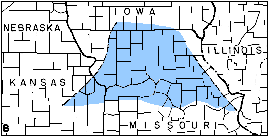
The distribution of dolomite and limestone in northeastern Kansas and northern Missouri and the belt of transition from limestone to dolomite is shown in figure 6. In northern Missouri the available information concerning the Kimmswick is from a limited number of wells studied by the writer and from reports by McQueen and Greene (1938). The dolomite phase lies toward the deeper part of the basin of deposition. It is apparent that the areas of dolomite and limestone deposition in Kansas are extensions of similar areas in northeastern Missouri.
Figure 6A--Sketch map showing distribution of calcareous and dolomitic phases of the Kimmswick limestone and intervening transition zone in northeastern Kansas and northern Missouri.
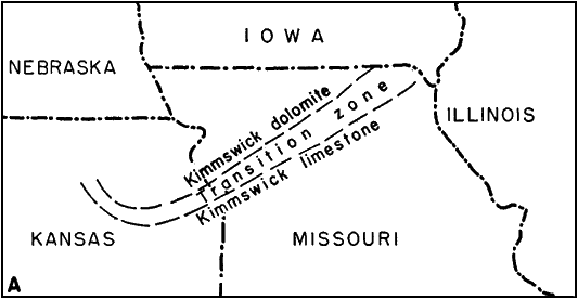
Figure 6B--Sketch showing by crosshatching the areas in northeastern Kansas and northern Missouri from which Maquoketa shale was removed by pre-Devonian erosion. Data in northeastern Missouri after Grohskopf, Hinchey, and Greene (1939, pl. 2).
The chert of the Kimmswick has some unique features, although there is considerable regional variation. Most of the samples of chert show irregularly distributed black flecks from the size of silt grains to dustlike particles. These flecks are composed mainly of pyrite but some may be phosphatic. Some of the chert contains silicified masses of broken foraminifera in which there are many microscopic circular black patches suggesting broken tubes. Although these markings are not unique, they are a prominent characteristic of parts of the Kimmswick.
The Kimmswick limestone in northeastern Kansas in areas where it is overlain by the Maquoketa shale increases in thickness toward the north. It is 95 feet thick in northern Douglas County, 107 feet thick in central Wabaunsee County, 180 feet thick in Doniphan County, and 248 feet thick in the Arab No. 1 Ogle well, in sec. 9, T. 1 N., R. 14 E., Nebraska. The Kimmswick is thin or absent where it was exposed to pre-Devonian erosion.
The stratigraphic relation of the Kimmswick limestone to the underlying Decorah shale is obscure. However, the lithologic relation of the Decorah and Kimmswick in some wells suggests, at least locally, that the rocks reported as Decorah in northeastern Kansas are basal clastic beds of the Kimmswick. The Kimmswick is definitely unconformable below the Maquoketa shale. It seems possible that the upper or noncherty zone is of Fernvale age. The possibility of an unconformity between this zone and the middle Kimmswick has already been mentioned.
The three divisions of the Kimmswick described by McQueen and Greene (1938, pp. 40-42) in northwestern Missouri are recognized in northeastern Kansas. These consist of an uppermost zone of dolomite with minor amounts of insoluble residues, a middle cherty zone, and a basal sparsely cherty zone.
The uppermost or noncherty zone was reported by McQueen and Greene to be of probable Trenton age. The rocks of this zone are mainly dolomitic, but locally include some limestone, as in the Smith et al. No. 1 Al Smith well, in sec. 28, T. 12 S., R. 19 E. The rocks of this zone are reported to contain small amounts of white and brown chert in Missouri, but in Kansas no chert was noted. The insoluble residues are characterized by semiopaque, vesicular quartz and drusy and fibrous quartz resulting from incomplete and imperfect replacements of shells of brachiopods. The amount of insoluble residues is ordinarily from 3 to 10 percent, but in a few samples it constitutes 15 to 25 percent. This zone is absent in some wells in parts of Johnson and adjoining counties where pre-Devonian erosion removed the upper part of the Kimmswick. The thickness of this zone increases somewhat irregularly from 5 to 10 feet in northern Johnson County and northern Douglas County to 20 to 40 feet farther north and varies inversely with the thickness of the underlying cherty zone in such a way as to suggest the presence of a disconformity between these zones. If the Prosser age of the cherty beds of the Kimmswick is accepted, this zone probably represents the Stewartville which is reported by Kay (1935, p. 295, fig. 211) to be disconformable above the Prosser. In the Arab No. 1 Ogle well, in sec. 9, T. 1 N., R. 14 E.; Nebraska, this noncherty quartzose zone is 37 feet thick and is overlain by 55 feet of cherty dolomite. The insoluble residues of this upper dolomite consist of 20 to 60 percent yellow-gray opaque chert mottled with patches of semiopaque vitreous chert containing spicules and same dark-gray coarsely dolocastic chert. This higher zone was not found in the nearest wells in Kansas, about 50 miles to the south. The insoluble residues from the noncherty dolomite zone at the top of the Kimmswick in Kansas closely resemble the residues described by Ireland (1936, p. 1101) in the Fernvale of Oklahoma, Residues from samples of the Fernvale in southwestern Illinois consisted almost entirely of partial replacements of shells by fibrous quartz that Ireland described as "acicular white fossil replacements."
The middle or cherty zone of McQueen and Greene is well developed in Kansas where it is divisible into three members: a very cherty member at the top, a sparsely cherty member in the middle, and a cherty member at the bottom of the zone. The chert in the uppermost member of this zone varies considerably in different parts of the area, but maintains a strong similarity. In Pottawatomie and Riley counties it is buff to brownish-gray and is composed of masses of finely broken formanifera poorly preserved in either semivitreous or opaque chert. The semiopaque chert of these counties is irregularly splotched with tripoli-like dust giving the chert a texture that may be described as curdled. The foraminiferal content decreases toward the east where the chert becomes grainy with occluded silt or shows a stippled pattern on the smooth fractures. The color changes from buff to light gray toward northwestern Missouri. The chert reflects the change from dolomite to sublithographic limestone in Johnson County, where, instead of being foraminiferal or silty, it is massive and either semiopaque or semitranslucent. Chert constitutes from 10 to 20 percent of the volume of the cuttings at the top of the upper member of the cherty zone and increases to 70 to 80 percent at the base, below which there is an abrupt decrease in the amount of chert. The break from high to low chert content is striking and presents a sharp datum horizon throughout much of the area. The upper part of the cherty zone is 20 feet thick in Shawnee County, Kansas, and 55 feet thick in the Arab No. 1 Ogle well, in sec. 9, T. 1 N., R. 14 E., Nebraska. The relation of the thickness of the uppermost member of the cherty zone above the datum horizon mentioned to the thickness of the overlying noncherty quartzose zone suggests an unconformity at the top of the cherty zone, and tends to confirm McQueen's conclusions that an unconformity exists above the cherty zone in northwestern Missouri. Toward the southeast the upper part of the cherty zone was removed by pre-Devonian erosion.
The middle member of the middle or cherty zone in Kansas is generally dolomitic, but it is calcareous in Riley and Pottawatomie counties and in Johnson and adjoining counties on the southeast. The chert rarely exceeds 5 percent of the sample and usually constitutes only a trace. It is almost invariably accompanied in the insoluble residues by small amounts of drusy crusts and crumbs of clear to semitranslucent quartz and fibrous quartz. These residues represent the imperfect and partial replacement of coarse fossils by quartz. Some of the semiopaque fibrous quartz recovered in the insoluble residues shows the imprint of brachiopods and is flecked with fine pyrite crystals. The thickness of this noncherty middle member varies widely because it becomes cherty and merges with the rest of the cherty zone in northwestern Missouri and because toward the west the lowest member of the cherty zone is less sharply defined. The middle member of the cherty zone has a thickness of 60 feet in Pottawatomie County, where it encroaches on or replaces a part of the underlying cherty beds. It has a thickness of 15 to 20 feet toward the east where it is encroached upon or becomes equivalent to part of the underlying chert member.
The lower cherty member of the middle zone of the Kimmswick limestone in northeastern Kansas is similar to the upper cherty member except that the chert shows a stippled or grainy pattern instead of the foraminiferal character. However, toward the east, where the chert in the uppermost member becomes grainy and silty, the lower member is finely microfossilferous. As in the upper cherty member, the color changes from buff to gray and white toward the east. The amount of chert is more variable than in the upper part of the zone. In some wells the amount of chert in the cuttings is nearly 100 percent but the average is much less. The amount of chert in the lower member of the zone gradually increases downward breaking off sharply at the base in some wells. This member becomes less cherty toward the west in Shawnee and Wabaunsee counties where only 5 to 20 percent of the rock is chert. Similar amounts of chert occur in Riley and Pottawatomie counties where the cherty zone is calcareous. In a few places some fine sand occurs in the lower member, of the cherty zone. Chert with black flecks of pyrite is particularly characteristic of the lower part of the cherty zone. The thickness of the lower member of the cherty zone is less than 10 feet in Pottawatomie County but increases to more than 50 feet in Doniphan County where the Kimmswick closely resembles that in northwestern Missouri.
The basal sparsely cherty zone of the Kimmswick limestone resembles the sparsely cherty parting of the middle zone. This zone overlies the Decorah shale in most wells; however, it is absent in some wells and the cherty or middle zone thus directly overlies the Decorah shale. This basal zone of the Kimmswick is composed of sucrose to crystalline dolomite or sublithographic limestone, depending on the area. The insoluble residues contain traces of grainy opaque chert, but are characterized by drusy and fibrous quartz of partially replaced fossils. The zone commonly has traces of disseminated, medium fine, rounded sand grains which are particularly abundant in places where shale beds of the Decorah are not recognized. The thickness of this member ranges from a feather-edge in the west, where the Decorah is thick, to 40 feet in Atchison county, where the Decorah is thin. The sandy parts of the formation may be partial equivalents of the Decorah.
Maquoketa Shale
The Maquoketa shale (of Richmond age) is the youngest Ordovician formation known to be represented in northeastern Kansas. The type locality of the Maquoketa shale is in Dubuque County, northeastern Iowa. The Maquoketa shale crops out in eastern Missouri, Illinois and elsewhere in the Mississippi valley. It is equivalent to the Sylvan shale of Oklahoma.
Ladd (1929) described the Maquoketa shale at outcrops in Iowa as consisting of 190 feet of green or blue shale "with a few feet of thin limestone layers at the top and an even thinner zone of indurated beds at the base." The formation thickens northwest from the type locality. It has been divided into four members: the Brainard shale member at the top with a variable thickness up to 100 feet; the Fort Atkinson member consisting of 40 feet of cherty dolomite and limestone; the Clermont member consisting of 10 to 40 feet of bluish plastic shale; and the Elgin member at the base composed of 70 feet of variable shaly limestone, calcareous clay, and dolomite. Rowley (1908) describes the Maquoketa at outcrops in Pike County, northeastern Missouri, as about 100 feet thick and consisting of light-blue shale, sandy in places; the softer shales are separated by hard beds that are argillaceous in some places and calcareous in others.
The Maquoketa shale in Kansas is variable in character. In some parts of the area, as in the Arab No. 1 Ogle well, in sec. 9, T. 1 N., R. 14 E., Nebraska, where the upper part of the formation has been eroded, the Maquoketa is composed almost entirely of shale. Elsewhere, however, it is roughly separable into an upper and a lower part, but each presents considerable lithologic variety. Throughout most of the area the upper zone is an impure dolomite, the insoluble residues of which consist of loose aggregates of dolocastic siltstone and fine sand. Some spongy dolocastic shale is also present. Part of the residual silt is densely cemented by semiopaque bluish to gray dolocastic chalcedonic chert. Some residues reveal the presence of spicular chert and loose coarse siliceous spines. Glauconite has been observed in the insoluble residues of the coarser parts of the silty dolomite. This silty and cherty dolomite may be roughly equivalent to the Fort Atkinson member of Iowa. The Brainard shale member is generally not present, though it may be represented locally in Atchison and Brown counties.
The lower part of the formation is much more argillaceous and consists for the most part of dolomitic slightly silty dark clay or clay shale. In Pottawatomie and Riley counties micaceous clay shale, mixed or interstratified with silty clay, forms the lower part of the Maquoketa shale. The insoluble residues of the lower part are dolocastic. Much of the insoluble residues is loosely spongy silty clay which originally formed a matrix for closely set fine crystals of dolomite. Black flakes of organic material which suggest broken fragments of graptolites are common in the lower or argillaceous zone. Pseudo-graptolite fragments occur locally in the upper part of the formation also, but they are uncommon in Kansas. The lower dolomitic and silty clay shale may be the approximate equivalent of the Elgin and Clermont members' of the Maquoketa in northeastern Iowa which were described by Calvin (1906).
The thickness of the Maquoketa shale in northeastern Kansas shows little variation except in those wells in which pre-Devonian or pre-Silurian erosion has reduced its original thickness. It is 75 feet thick in central Wabaunsee County, 75 feet thick in eastern Riley County, 82 feet thick in Pottawatomie County, and 64 feet thick in Shawnee County. The thickness has increased to 111 feet in northwestern Missouri in the Birkett et al. No. 1 McGee well in Andrew County. The formation continues to thicken slightly toward the northeast at outcrops in Iowa.
The Maquoketa shale lies unconformably on the Kimmswick limestone. The pre-Maquoketa surface must have been extremely flat, for although the Maquoketa shale was deposited upon the middle or cherty member of the Kimmswick toward the southeast and upon 92 feet of the upper Kimmswick member toward the northwest, it has in northeastern Kansas a singularly uniform thickness without pronounced local variations.
The Maquoketa shale is unconformable below the Silurian rocks in the Arab Ogle well. Hematitic "flaxseed" oolite in red shale forms the base of the Silurian in this well. The upper dolomitic zone of the Maquoketa is absent and the upper beds consist of red weathered shale. In the Isaacks No. 1 Magor well, in sec. 15, T. 5 N., R. 15 E., Nebraska, only about 20 feet of probable Maquoketa intervenes between the base of the Silurian and the Kimmswick. The well was drilled with rotary tools, however, and the thickness as determined from well cuttings may be incorrect. A thinning of the Maquoketa has also been noted in northwestern Missouri in the Jackson and Rust No. 1 Hayes well, in sec. 22, T. 66 N., R. 42 W.
The Maquoketa shale was originally deposited throughout northern Missouri and Kansas and probably across the Chautauqua arch in continuation with the Slyvan shale of Oklahoma. Large areas of Maquoketa shale together with older and younger rocks were stripped from southeastern Kansas and from northern Missouri, as shown by the unconformity at the base of the Devonian rocks (fig. 6). The Maquoketa was very generally eroded from the northern end of the Nemaha anticline at the end of Mississippian time when that area was raised and peneplaned. The Maquoketa may be expected beneath the Pennsylvanian rocks in a narrow belt encircling this truncated fold, but elsewhere Devonian and Silurian rocks intervene.
Prev Page--Stratigraphy--Cambrian || Next Page--Stratigraphy--Silurian
Kansas Geological Survey, Forest City Basin
Comments to webadmin@kgs.ku.edu
Web version July 2005. Original publication date Dec. 1943.
URL=http://www.kgs.ku.edu/Publications/Bulletins/51/03_strat2.html