![]()
Prev Page--Introduction || Next Page--Stratigraphy--Ordovician
Stratigraphy
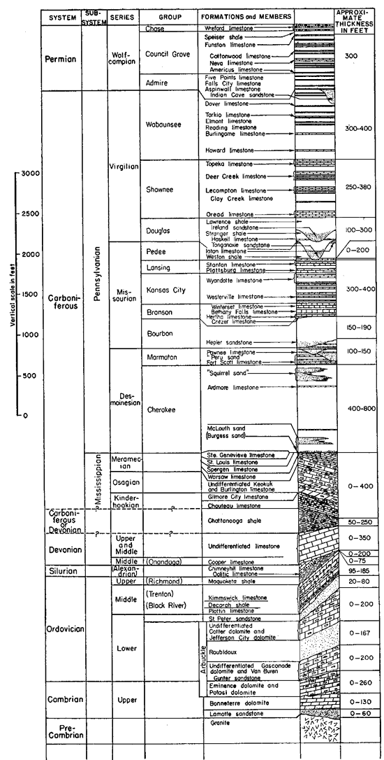
The sequence of rocks in the Forest City basin is shown in generalized form in the columnar section (fig 3). The structural features are such that nearly every one of the formations below the Pennsylvanian is absent in some part of northeastern Kansas and there is no locality in which all the formational units are now present although almost all were originally deposited throughout the area.
Figure 3--Columnary section of rocks in northeastern Kansas, showing sequence and variations in thickness of stratigraphic units mentioned in this report. The classification is in accordance with the usage of the State Geological Survey of Kansas. Only the more prominent formations and members of the Pennsylvanian and Permian are shown. The angular unconformities in the pre-Pennsylvanian rocks are greatly exaggerated. A larger version of this figure is available as an Acrobat PDF file (92 KB).
General Features and Relations of Rocks of Precambrian and Cambrian Age
Outcrops of rocks of Precambrian age nearest to northeastern Kansas are in southeastern Missouri, where they form the core of the St. Francis mountains. They consist chiefly of red and gray granite with subordinate amounts of schist and porphyry, and are unconformably overlain by Upper Cambrian sandstone. Similar rocks are found at the surface in parts of eastern and southern Oklahoma in the same relation to Upper Cambrian rocks. Red quartzite of Precambrian age is exposed in southeastern South Dakota and in small areas in adjoining states.
A great unconformity separates the Cambrian rocks from the Precambrian (crystalline) rocks. The Precambrian surface in the midcontinent region had a low relief when it was covered by Upper Cambrian sedimentary rocks. The Precambrian and younger rocks have been brought to their present position in southeastern Missouri by a number of separate structural movements, and their exposure in that area is the result of long periods of erosion separated by periods of structural movement and deformation. In Kansas the Precambrian rocks have been subjected to similar influences and were exposed in pre-Pennsylvanian time at places along the Nemaha anticline and on the Central Kansas uplift. They were later lowered to a position below sea level and covered by younger sediments and, although re-elevated, have not yet been re-exposed.
The Precambrian rocks of Kansas consist mainly of granite, gneiss, and schist, but Landes (1927, p. 823) and others have reported wells that penetrated also basic igneous rocks, quartz porphyry, and quartzite. Landes concluded that the Precambrian rocks of Kansas and adjoining states consist of a complex composed principally of granite or granite gneiss or schist; locally it may contain other igneous and metamorphic rocks. Most of the samples of Precambrian rocks now available from wells that penetrated the Precambrian of northeastern Kansas appear to represent red granite; red quartzite is reported by McQueen from Greenwood, Jackson County, Missouri, which adjoins Johnson County, Kansas.
The Precambrian rocks are hard and difficult to drill. The churn drill was used in most of the wells in northeastern Kansas. The cuttings of these wells are, therefore, generally fine and the relatively less resistant feldspars and accessory minerals are reduced to rock flour. For this reason, many of the washed samples consist of a disproportionate amount, or may consist entirely, of fine angular quartz grains and the granite is thus reported as sandstone in the logs of many of the early wells. Even where traces of feldspar, mica, and other minerals can be identified, it is impossible in many cases to determine whether the rock is granite or gneiss.
The Cambrian and Ordovician rocks in Missouri were grouped together for many years under the term Cambro-Ordovician. Similarly, in Oklahoma the Arbuckle limestone or "Siliceous lime" consisted of undifferentiated Cambrian and Ordovician rocks.
The Arbuckle limestone of Oklahoma was originally defined by Taff (1902) as including all the rocks from the top of the Reagan sandstone up to the base of the Simpson group. The corresponding interval in southeastern Missouri was long presumed to extend from the top of the Lamotte sandstone up to the base of the St. Peter sandstone or the base of the Everton where that formation is present. Ulrich (1911, pp. 624, 642, 666), however, identified the Honey Creek limestone of Oklahoma as of Cambrian age and later (1932, p. 742) excluded it from the Arbuckle. He also in 1932 identified the Honey Creek as essentially equivalent to the Davis formation of Missouri. In consequence, the underlying Bonneterre dolomite of Missouri is excluded as a correlative of the Arbuckle. Furthermore, the Derby and Doe Run dolomites, which conformably overlie the Davis and underlie a well-defined and widespread unconformity, should also be excluded from the Arbuckle.
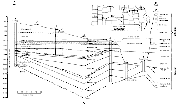
The term Arbuckle as redefined by Ulrich, although no longer so inclusive a term as in its original sense, is still a convenient term to indicate undifferentiated pre-St. Peter Ordovician and Cambrian rocks in Kansas. In Missouri (fig. 4) the equivalents of the Arbuckle include the Potosi, Eminence, and Proctor dolomites, the Van Buren formation, the Gasconade dolomite, the Roubidoux formation, and the Jefferson City, Cotter, and some younger dolomites not represented in Kansas.
Figure 4--Cross section in southern Missouri from west to east on line A-B (see also fig. 10) showing structural relations of the Roubidoux formation to pre-Roubidoux rocks, The cross section s based on well logs with the Roubidoux formation as the datum plane. Replotted from cross section by McQueen (1931, pl. 12). The cross section shows pre-Potosi deformation, peneplanation, and overlap of formations younger than the Potosi dolomite, Similar relations are shown at the base of the Van Buren formation. A larger version of this figure is available as an Acrobat PDF file (128 KB).
The following columnar section of St. Peter and older rocks of Ordovician and Cambrian age in Jackson County, Missouri, near the Kansas border, is reported from well cuttings by H. S. McQueen (Letter dated February 18, 1942). Some of the formations shown in figure 4 are missing by reason of unconformities. The thicknesses, however, are only approximate, for the determinations were made from a set of samples that had long gaps between some samples. This well is shown diagrammatically in cross section in figure 5.
Figure 5--Cross section from west to east on line C-D (see also fig.. 10) from Pottawatomie County, Kansas, to Jackson County, Missouri, showing structural relations of St. Peter sandstone to pre-St. Peter rocks. The chief unconformaties are at the base of the Lamotte, Potosi, Van Buren, Roubidoux, and St. Peter formations. Formational boundaries of well No. 1 by Wallace Lee and R.P. Keroher, State Geological Survey of Kansas; and well No. 4 by H.S. McQueen, Missouri Geological Survey. A larger version of this figure is available as an Acrobat PDF file (128 KB).
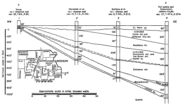
Table 1--Sequence and approximate thickness of St. Peter and older rocks of Ordovician and Cambrian age in a well near Greenwood, Jackson County, Missouri, sec. 27, T. 47 N., R. 31 W.
| Rocks of Ordovician age | Thickness, feet |
|
|---|---|---|
| St. Peter sandstone | 80 | |
| Cotter and Jefferson City dolomite | 210 | |
| Roubidoux formation | 135 | |
| Gasconade dolomite | 192 | |
| Rocks of Upper Cambrian age | ||
| Eminence dolomite | 263 | |
| Potosi dolomite | 50 | |
| Bonneterre dolomite | 130 | |
| Lamotte sandstone | 60 | |
| Rocks of Precambrian age | ||
Rocks of Cambrian Age
The Cambrian-Ordovician boundary in Missouri (McQueen, 1931) is placed between the Proctor dolomite and the Gunter sandstone member of the Van Buren formation (fig. 4). The Missouri formational names are used in the present report because they antedate the Oklahoma names and also because they have been extended from the outcrops in Missouri to the Kansas border by the Missouri Geological Survey by means of insoluble residue studies of well cuttings.
Lamotte Sandstone
The Lamotte sandstone of Upper Cambrian age overlies Precambrian granite in southeastern Missouri. In southern Oklahoma, the Reagan sandstone, also of Upper Cambrian age, has a similar relation to the Precambrian rocks. McQueen (1931, pl. 3) described the Lamotte sandstone as yellow to white sandstone with fine to coarse subangular and rounded grains. It is generally arkosic at the base and locally dolomitic in some zones. Sandstones that appear to be of the same age as the Lamotte and Reagan are found in most places in the subsurface of eastern Kansas. If the sandstone is arkosic, it is difficult to distinguish it from the underlying granite or gneiss, and the exact point of contact may be in doubt. A few samples of granite and Cambrian rocks from wells in northeastern Kansas are on file at the State Geological Survey, but most of the deep wells that penetrated the older rocks in this region were drilled before it was customary to preserve well cuttings.
The Lamotte sandstone has a maximum thickness of about 350 feet in southeastern Missouri. In southwestern Missouri it is about 150 feet thick and in northeastern Kansas it is thinner. In the Kasper No. 1 James well, in the NE NW sec. 9, T. 13 S., R. 25 E,, the Lamotte is 30 feet thick, and in the Duffens et al. No. 1 Stanley well, in the NW NE sec. 3, T. 14 S., R. 21 E., only 7 feet of Lamotte sand is present. In the Forrester et al. No. 1 Hummer well, in the NW SE sec. 14, T. 11 S., R. 16 E., where samples through an interval of 15 feet are missing, the Lamotte is at least 22 feet thick and may be 40 feet thick. It is less than 5 feet thick in the Turner No. 1 Umschied well, in sec. 32, T. 8 S., R. 9. E.
There is a great unconformity between the Lamotte sandstone and the underlying Precambrian rocks. The Lamotte sandstone is transitional into the overlying Bonneterre dolomite,
Bonneterre Dolomite
The Bonneterre dolomite crops out only in southeastern Missouri, but it is present in the subsurface throughout most of Missouri and in most of eastern Kansas. McQueen (1931, pl. 3) describes the Bonneterre as consisting of fine to coarsely crystalline dolomite and magnesian limestone with almost no chert. The dolomite is light-colored to brown with interbedded green and brown shales, with insoluble residues of dolocastic shale of a type not observed in younger Cambrian and Ordovician formations. Glauconite and sand are characteristic constituents.
The Bonneterre dolomite has a maximum thickness of 440 feet in southeastern Missouri, but is not much more than 200 feet thick in southwestern Missouri. In northeastern Kansas, the Bonneterre has a maximum known thickness of 91 feet in Douglas County and decreases slowly toward the northwest. In Pottawatomie and Riley counties there is 20 feet of noncherty argillaceous limestone which is believed to be of Bonneterre age between a thin section of Lamotte sandstone and the St. Peter sandstone. In the Arab No. 1 Ogle well in sec. 9, T. 1 N., R. 14 E., Nebraska, just across the state line from Kansas, the Bonneterre is absent and the St. Peter sandstone rests directly on the Precambrian.
The Bonneterre conformably overlies the Lamotte sandstone in southeastern Missouri. It is conformably overlain by the Davis formation, which in turn is overlain in conformable sequence by the Derby and Doe Run dolomites. Only the Davis formation extends into southwestern Missouri, as shown in figure 4, and all three are absent in eastern Kansas, so that the Bonneterre is unconformably overlain in most localities by the Eminence dolomite. The Bonneterre in northeastern Kansas becomes thinner toward the west (fig. 5). This thinning seems to be due to erosion which preceded the deposition of the Eminence dolomite.
Potosi Dolomite
The Potosi dolomite is exposed only in southeastern Missouri. McQueen (1931) describes it as brownish-gray to chocolate-colored dolomite with an abundance of dense chert in the insoluble residues. The Potosi was probably deposited in a broad structural and erosional basin centering in southeastern Missouri. The Potosi has a maximum known thickness of 480 feet and becomes thinner toward the margins of the basin.
The Potosi unconformably overlies the Doe Run, Derby, Davis, and Bonneterre formations, but is conformably overlain by the Eminence dolomite (fig. 4). From southeastern Missouri, the Potosi becomes thinner toward the west and northwest. If present at all in northeastern Kansas, it is represented only by a thin wedge near the Kansas border between the Bonneterre and the Eminence.
Eminence Dolomite
The Eminence dolomite of southeastern Missouri is described by McQueen (1931) as a crystalline light-colored dolomite in contrast with the light-brown to chocolate-colored dolomite of the Potosi. Gray and light-blue vitreous chert is abundant, and siliceous oolite is common in the Eminence. The insoluble residues of the Eminence are characterized by dolocastic cavities which are so abundant that they resemble a lacelike sponge. The Eminence dolomite is well developed in eastern Kansas, but in northeastern Kansas it contains much less chert than in the deeper parts of the basin of deposition in southern Missouri. The maximum thickness of the Eminence dolomite reported by McQueen in southeastern Missouri is 320 feet. It is about 200 feet thick at Carthage in southwestern Missouri. Keroher has determined its thickness as 175 feet in northeastern Kansas in the Duffens No. 1 Stanley well, in sec. 3, T. 14 S., R. 21 E. The formation is not present on the northwestern edge of the basin (fig. 5).
The Eminence formation is conformable upon the Potosi and conformable below the Proctor dolomite (fig. 4). Both of these formations are absent in northeastern Kansas, so the Eminence unconformably overlies the Bonneterre dolomite and is in turn unconformably overlain by undifferentiated Van Buren and Gasconade dolomites.
Proctor Dolomite
The Proctor dolomite is a noncherty dolomite conformably overlying the Eminence in south-central Missouri. If does not occur in northeastern Kansas.
Prev Page--Introduction || Next Page--Stratigraphy--Ordovician
Kansas Geological Survey, Forest City Basin
Comments to webadmin@kgs.ku.edu
Web version July 2005. Original publication date Dec. 1943.
URL=http://www.kgs.ku.edu/Publications/Bulletins/51/03_strat.html