Kansas Geological Survey, Bulletin 211, Part 1, originally published in 1976
Originally published in 1976 as Kansas Geological Survey Bulletin 211, Part 1. This is, in general, the original text as published. The information has not been updated.
A study of stream valley cross sections and longitudinal profiles indicates that the pre-Kansan drainage in the Upper Tuttle Creek Reservoir area was northward, from the Randolph Divide along a course now occupied by the Black Vermillion River, into an east-flowing pre-Kansan tributary of the hypothetical preglacial Grand River. The east-flowing tributary, now buried under 300 to 400 feet of Kansas Glacial Deposits, was part of a drainage system that included the east-flowing Little Blue and the south-flowing Big Blue Rivers.
During Kansan (Nickerson) time a lobe of the glacier blocked the eastward drainage of the Grand River and a proglacial lake formed in the tributary draining north from the Randolph Divide. Overflow from the lake was southward through a nickpoint in the divide. This reversal of drainage produced a 300 to 400 foot deep gorge across the Randolph Divide. Terraced bedrock of the gorge now buried under alluvium suggests two major erosional cycles. Additional evidence for more than one period of erosion is found downstream in the Lower Kansas River drainage below Manhattan where the Kansan, Illinoisan, and Wisconsin alluvial terraces have significant elevation differences. The nickpoint on the Randolph Divide, driven northward by headward erosion, currently appears to be in the vicinity of Blue Rapids.
In the early 1950's the author investigated the large sinuous bends of the pre-reservoir Big Blue River and the apparent lack of upstream narrowing of the valley over a distance of more than 50 miles between Manhattan and Marysville. A study of the anomalies in terms of tectonic, glacial, or a combination of these considerations was initiated at that time. The tectonic factors were evaluated and, except for joints which appear to control the sinuous curves, the structure and varying resistances of the stratigraphic units do not have significant effect on the drainage pattern. Thus the explanation for the lack of convergence of valley sides upstream appeared to be primarily the result of glaciation. However, at the time of the initial investigation the glacial factors could not be properly evaluated because of a lack of bore hole data, adequate map coverage, and the absence of a good plane of reference for measuring variations in the width of the valley. The publication by Frye and Walters (1950) on the Subsurface Reconnaissance of Glacial Deposits in Northeast Kansas, the investigation by the Army Corps of Engineers in the planning of Tuttle Creek Reservoir, the publication of a new series of topographic maps giving complete coverage of the area, and the release of valuable flood plain bore hole data by the State Highway Commission Geology Department made possible the current investigation.
The Big Blue River and its relationship to the hypothetical Grand River and Lower Kansas River Valleys (Heim and Howe, 1963) is summarized by Dreeszen and Burchett (1971) on a regional basis that is far greater than the scope of this paper. However, the local setting must fit into the regional pattern, and appears to do so without major modification.
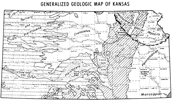
Geologically, Tuttle Creek Reservoir lies astride the Irving Syncline and Abilene Anticline (Chelikowsky, 1972) and is located along the boundary between Riley and Pottawatomie counties. This is also essentially the southwest limit of the Kansan (Nickerson) Glacier (Fig. 1). Bayne (1969) subdivided Kansan Glaciation into an early Nickerson Stade of major importance and a lesser medial Kansan Substage, the Cedar Bluff Stade. The Nickerson glaciation did not extend beyond the Little Blue River (Fig. 2), and the Cedar Bluff glaciation did not reach the area of Tuttle Creek Reservoir (Reed and Dreeszen, 1965). The joint plane control of the drainage pattern and the geologic structure of the region, including a reference to stream reversal because of glaciation, was published by Chelikowsky (1972).
Figure 1--General location of the Kansas Glacial Till. Tuttle Creek Reservoir lies immediately to the west along the boundary between Riley and Pottawatomie Counties.
Measurements of valley widths at the maximum reservoir elevation of 1136 feet above sea level were made the full length of the reservoir and beyond, into the Little Blue and Black Vermillion tributaries (Fig. 2). Minimum widths within every two miles were recorded in units of 500 feet as shown on the map. Also shown are points of maximum sea level elevations recorded at about two-mile intervals along the major stream divides. Cross-section sites were generally located where a marked change in the width of a valley occurred. They are shown by lettered lines, but are not necessarily as long as the line indicates.
Figure 2--Tuttle Creek Reservoir showing elevations of the principal divides in feet above sea level and variations in the width of the valley at the full reservoir elevation of 1136 feet. Valley widths are shown in 500-foot units. The lettered lines refer to cross sections shown in Figures 3 and 4.
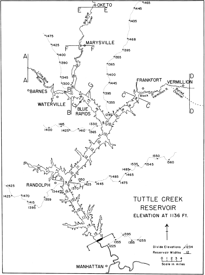
The data on valley widths are measurements at the 1136 foot level and show an upstream narrowing from 15 units above the dam to 9 units at Randolph. The difference of 6 units amounts to approximately 3168 feet of narrowing over a distance of 12 miles. North of Randolph the valley widens from 9 to 13 units (2112 feet) in about 9 miles. The valley then narrows from 13 to 10 units near the junction with the Black Vermillion (4 miles) and continues to narrow upstream along the Black Vermillion; but along the Big Blue upstream from the Black Vermillion junction, the valley increases in width from 10 to 13 units just before reaching Blue Rapids. Here it rapidly narrows to 5 units in a little over 2 miles. Thus, there are three major valley constrictions along the course of the Big Blue: (1) at Randolph, (2) below the junction with the Black Vermillion, and (3) at Blue Rapids.
The Randolph divide posed the greatest barrier to southward movement of the Kansas glacier, although to the east of the town of Randolph, in the area where elevations reach above 1500 feet, thin till deposits cover the divide and extend into the Kansas River Valley. Although there are no till deposits on the Randolph divide in the proximity of the reservoir, a glacio-fluvial deposit known as the Little Gobi Desert does occur. The best exposure of the sands of the Little Gobi Desert is located on the east side of Tuttle Creek Reservoir one mile south of section H-H (Fig. 2) covering an area of more than half of a square mile.
The bulk of the Kansas (Nickerson) glacial till seems to be confined between the Randolph divide and the divide between the Big Blue and Vermillion Rivers east of Frankfort. South of the town of Vermillion (Frye and Walters, 1950) the till is between 300 and 400 feet thick. The glacial ice (Nickerson) probably extended as far west as that portion of the Little Blue River between Blue Rapids and Waterville, because in this area glacio-fluvial terrace deposits occur (Lill, 1946). Farther upstream, in the area of section A-A, non-glacial (pre-Kansan) deposits are shown on the geologic map of Kansas (Jewett, 1964). The location of the buried channel south of the town of Vermillion is from the map of Bayne and Ward (1967).
Speculation concerning the cause of the three valley width constrictions led to the formulation of the glacial hypothesis of drainage reversal for that section of the Big Blue north of Randolph (Upper Tuttle Creek Reservoir). It was assumed that the constricted areas represent abrupt changes in stream gradients and that the one at Randolph was the nickpoint of drainage reversal. Cross-section data and longitudinal profile-structural data support the hypothesis.
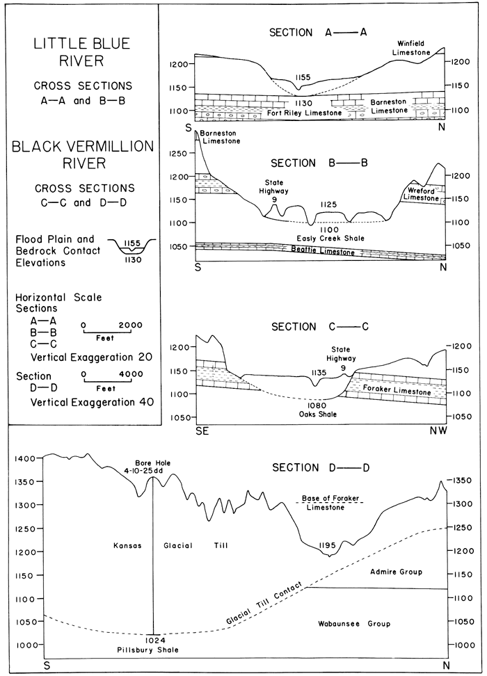
The cross sections (Figs. 3 and 4) do not differentiate flood-plain sediments from older deposits, but careful scrutiny will reveal some differences in terrace levels which make it possible to distinguish between the deposits and to differentiate between erosional and depositional age relationships.
The sections A-A and B-B across the Little Blue River and C-C and D-D across the Black Vermillion River (Fig. 3) show bedrock valley floor sea level elevations that are progressively lower from 1130 in A-A to 1024 feet in D-D. In section A-A the flood-plain elevation of 1155 is about 10 to 15 feet below an older terrace deposit, possibly Kansan to pre-Kansan in age. The flood plain is not well developed, and active erosion of the terrace seems to be in progress. In section B-B a broad flood plain at an altitude of 1125 feet spans two meanders of the Little Blue River. The terrace at the level of the State Highway K-9, section B-B (Fig. 3) is Kansas glacio-fluvial (Lill, 1946) and is approximately 20 to 25 feet higher than the flood plain. Here, the Little Blue River appears to be degrading and has cut into the underlying Easly Creek Shale. In section C-C, Black Vermillion River, the alluvium is about twice as thick as in the previous two sections, and an older terrace deposit is lacking. The stream appears to be aggrading. Section D-D shows the postulated buried tributary to the Grand River, the outlet of the Upper Tuttle Reservoir (north slope of the Randolph divide). It should be noted that none of the sections A-A, B-B, or C-C show buried bedrock terraces.
Figure 3--Little Blue River-Black Vermillion River cross sections showing the structure of the structure of the principal limestone formations and the specific bedrock unit that lies below the flood plain. All elevations are in feet above sea level. The numbers in each section refer to the surface of the flood plain and the underlying of bedrock contract.
The sections E-E through I-I (Fig. 4) are across the Big Blue River and represent pre-reservoir conditions. Note the progressively lower elevations of the bedrock valley floor from 1134 in E-E to 910 in 1-1. Also note that section H-H (Randolph) and I-I (damsite) show at least two bedrock terrace surfaces with the last terrace surface as much as 85 feet below the first terrace level. These two erosional cycles represented by the bedrock terraces are correlated with the terrace levels reported by Beek (1959) in the Lower Kansas River below Manhattan. Beek shows an early and a later Kansas Terrace, an Illinoisan Terrace, and multiple Wisconsin terraces. The early terrace is correlated with the early Kansan (Nickerson) and dates the first cycle of erosion, and the last bedrock terrace surface is correlated with the later Kansan (Cedar Bluff). Sections E-E (Oketo), F-F (Marysville), and G-G (Blue Rapids) do not show buried bedrock terraces and fall into the same category with A-A, B-B, and C-C in that respect. Apparently the area immediately north of the junction of the Black Vermillion and Big Blue Rivers was protected from the second cycle of erosion, possibly by the existence of a post-Nickerson lake that lingered on from the original proglacial lake.
Figure 4--Big Blue River cross sections. All elevations are in feet above sea level. The flood plain elevations for cross sections within the lake area are pre-reservoir values.
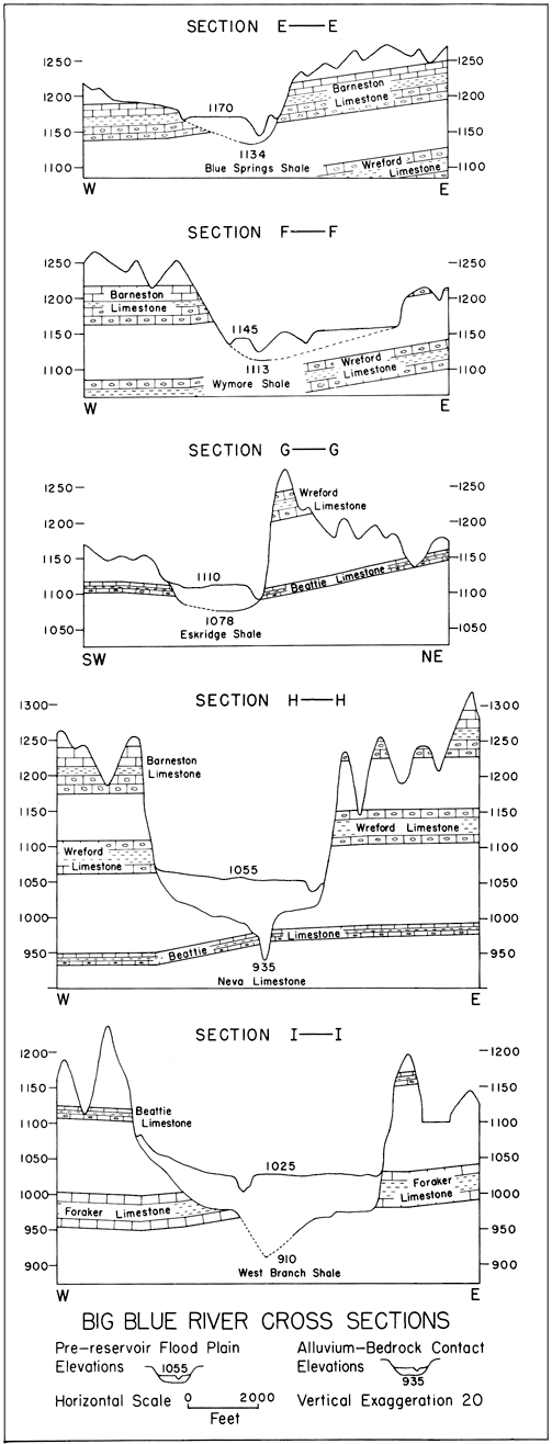
The H-H section at the Randolph divide shows the greatest amount of erosional relief in the reservoir area. It amounts to about 365 feet, extending from the site of the Little Gobi Desert at 1300 feet down to the 935 foot contact of alluvium with the Neva Limestone.
No cross section was made for the area of the junction of the Black Vermillion and Big Blue Rivers, but in the construction of the profile-structure sections (Fig. 5) a thickness of 45 feet of alluvium was used to determine the elevation of the bedrock contact. The 45 foot figure was obtained from Bayne's (1967) map. It was assumed that saturated thickness at this junction is essentially that of the alluvium since the water table is close to the surface.
Three longitudinal profile-structure sections were constructed from the cross-section data, and on each profile the same basic information was plotted: (1) the slope or gradient of the pre-reservoir flood plain, (2) the pre-Kansan and Kansan bedrock surface, (3) the post-Kansan erosion surface, and (4) the structure of the more resistant stratigraphic units (Fig. 5).
Figure 5--Longitudinal profile-structure sections based on the cross sections based on the cross sections of Figures 3 and 4. All elevations are in feet above sea level. Each section shows the relative variations in slope between the present or pre-reservoir floodplain, the pre-Kansan or Kansan bedrock surface, and the post-Kansan erosion surface. The synclinal structure of the Randolph Divide is the Irvine Syncline. The anticline is the Abilene.
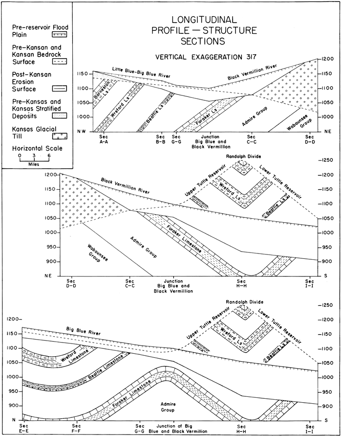
The top profile section (Fig. 5) was constructed along the course of the Little Blue-Big Blue and Black Vermillion Rivers. The northwest trending portion of the section cuts across the northwest flank of the southwest plunging Abilene Anticline, while the northeast trending portion of the section cuts across the southeast flank of the anticline. This accounts for the discrepancy in the dips in the section. The dashed line represents the slope of the pre-Kansan bedrock surface. Its position in the section was based upon the bedrock-pleistocene contact of cross sections A-A, B-B, C-C, and D-D. The increase in the eastward slope of the dashed line under the Glacial Till to the 1024 foot contact level is probably due to glacial scour of the bedrock surface. Note that on the basis of this postulated surface, the Little Blue-Big Blue stream drained eastward directly into the Grand River watershed along a course now occupied by the Black Vermillion River, and that the stream flowing northward off the Randolph divide in the area that is now the Upper Tuttle Creek Reservoir (see middle profile of Fig. 5) was a tributary to it. The pre-Kansan surface, as shown, was the surface over which the Nickerson Glacier spread. When the Nickerson Glacier advanced up the Little Blue-Big Blue stream beyond the point of juncture with the Upper Reservoir tributary, the condition for a reversal in drainage at the Randolph divide was established. It should be-noted that a large marginal or proglacial lake was not necessary, as long as meltwater kept the lake at a level higher than the nickpoint of drainage reversal. It is postulated that as the glacier waned, the pluvial period waxed to provide an adequate discharge for the cutting of a gorge across the Randolph Divide. When the downcutting reached the level of 1150 feet (Fig. 5), the glacial front bad probably receded beyond the junction point of the Little Blue-Big Blue Rivers. It was probably at this time that the glacio-fluvial terrace deposits of Lill (1946) were formed in the area between Waterville and Blue Rapids. Continued downcutting across the Randolph Divide to about the 1125 foot level (Beattie Limestone) probably occurred near the close of the Nickerson pluvial period. It seems probable that a post-Nickerson glacial lake existed in the area of the Abilene Anticline where the arched Beattie Limestone bad been breached. (See the middle and lower profiles of Fig. 5.) Considerably later in time, during the Cedar Bluff pluvial period, this area was again flooded, and erosion in the Randolph gorge was rejuvenated to the degree that an 80 to 90 foot inner gorge was cut below the level that bad been developed during the Nickerson pluvial period.
The erosion during the Cedar Bluff pluvial period drained the post-Nickerson lake and caused the nickpoint in the Beattie Limestone through which the lake was drained to migrate upstream to the vicinity of Blue Rapids. The difference in altitude of about 35 feet between the bedrock (solid line) and the pre-Kansan bedrock surface (dashed line) of the top profile (Fig. 5) is the amount of erosion that occurred. When the nickpoint through the Beattie Limestone reached Blue Rapids the stream gradient increased. This is reflected in the increased slope of the present-day flood plain and explains why the Little Blue River west of Blue Rapids has cut through the alluvium and into the Easly Creek Shale. On the Black Vermillion River, however, the condition of a large available load carried down a steep glacial till slope by a relatively small volume of water produced a progression of downstream aggradation. In concluding the discussion of the top profile of Fig. 5, attention is called to the relatively low gradient of 2.5 feet per mile for the Little Blue-Big Blue stream, indicating a relatively mature drainage system.
The middle profile of Fig. 5 extends from cross section D-D in the area of the buried Grand River watershed, west to Frankfort and southwest along the Black Vermillion to the junction with the Big Blue River and then generally southward along the upper and lower reservoir to the damsite. In this profile, the pre-Kansan bedrock drainage is shown as a hypothetically restored surface (dashed line) over the Randolph divide to show the division of drainage--north of the divide draining into the buried Grand River and south of the divide draining into the Lower Kansas River. The pre-Kansan and Kansan surface at 1250 to 1300 feet on the Randolph divide is based upon the elevation of the glacio-fluvial sands of the Little Gobi Desert. Note the abrupt increase in the slope of the post-Kansan erosion surface to the south of the junction of the Big Blue and Black Vermillion Rivers. This is the area (sections H-H and I-I) in which the Cedar Bluff pluvial period of erosion cut an inner gorge 80 to 90 feet below the level produced by the Nickerson erosion. Also note the relatively smooth surface of the pre-reservoir Big Blue flood plain as compared with the underlying variations in the slope of the post-Kansan erosional surface. The Black Vermillion flood plain surface has a gradient of about 4 feet per mile; the pre-reservoir Big Blue River flood plain surface a gradient of 2.6 feet per mile.
The bottom profile section (Fig. 5) is essentially a north-south section along the Big Blue River and the entire length of the reservoir. It portrays the Irving Syncline (Randolph divide) and the Abilene Anticline (between Blue Rapids, section G-G and the junction of the Black Vermillion and Big Blue Rivers). The syncline at the Randolph divide brought the resistant Barneston Limestone down to a lower level than less resistant formations to the north and south, causing it to be differentially eroded to form the highest divide in the area. The role of the Beattie Limestone as a temporary base level for a post-Nickerson glacial lake in the area of the Abilene Anticline was described in a previous section. The three points of major change in the gradient of the post-Kansan erosion surface (also reflected in a much subdued manner in the gradient of the present flood plain) are located at section (H-H) Randolph, the junction of the Big Blue and Black Vermillion Rivers, and section (G-G) Blue Rapids. They mark respectively the (1) nickpoint of drainage reversal on the Randolph divide, (2) the nickpoint in the draining of the post-Nickerson lake, and (3) the Beattie Limestone nickpoint at Blue Rapids. These three locations correspond to the three valley constrictions discussed earlier. Note that the Big Blue River flood plain from section E-E to the junction of the Big Blue and Black Vermillion Rivers has a gradient of 2.3 feet per mile compared with the flood plain gradient in the reservoir area of 2.6 feet per mile.
A number of features leave little doubt about the drainage reversal in the Upper Tuttle Creek Reservoir because of the effect of Kansas Glaciation: (1) the general narrowing and widening of the valley sides that are associated with the three major valley constrictions, (2) the occurrence of glacio-fluvial sands and gravels (Little Gobi Desert) on the Randolph divide, and the Kame Terraces along the lower Little Blue River, (3) the configuration of the lower reservoir cross sections showing buried rock terraces compared with those of the upper reservoir that do not, and (4) the existence of a buried Grand River Valley with ready access and outlet eastward.
Bore hole information on alluvium-bedrock contact elevations for bridge footings, as well as rock structure profile data along major highways of the area, supplied by Lowell W. Fowler of the State Highway Commission Geology Department are gratefully acknowledged. Completion of the project without these aids would have been impossible. Water well log data and general information relative to the regional glacial history of the area were supplied by Dr. H. V. Beck, Professor of Hydrogeology and Glaciology at Kansas State University. Bore hole information and a geologic cross section along the axis of Tuttle Creek Dam as well as information on the alluvium thicknesses in the Frankfort area were furnished by the Army Corps of Engineers. The general geologic map of Kansas, the distribution of glacio-fluvial, glacial till, and Kansan or older deposits were taken from published maps of the Kansas Geological Survey.
| Section A-A Four and one half miles north of Barnes |
North-South across the Little Blue River, 200 feet west and parallel to state highway K15E. The bedrock contact elevation of 1130 feet, Fort Riley Limestone, is based on state highway bore holes for the K15E bridge footings. |
| Section B-B Two miles west of Waterville |
North-South across the Little Blue River, 400 feet west of the Fawn Creek bridge on state highway K9. The bedrock contact elevation at the Fawn Creek bridge is 1108 feet and is based on state highway bore holes. Extrapolation of the sloping bedrock contact to the center of the Little Blue food plain lowers the contact to 1100 feet, Easly Creek Shale. |
| Section C-C One and one half miles southwest of Frankfort |
N65W-S65E across the Black Vermillion River through a point 500 feet southwest of the Robidoux Creek bridge on state highway K9. The bedrock contact elevation at the Robidoux Creek bridge is 1087 feet and is based on state highway bore holes. Extrapolation of the sloping bedrock contact and interpolated values from Bayne's (1967) Cenozoic Deposit Map showing water saturation thicknesses would lower the contact to about 1080 feet, Oaks Shale. |
| Section D-D One mile east of Vermillion |
North-South across the Black Vermillion River and along the boundary of Marshall and Nemaha counties. The section is essentially the B-B section of Frye and Walters (1950). The bedrock contact elevation of 1024 feet is based upon bore holes 4-10-25 dd of Frye and Walters. The stratigraphic level has been estimated as Pillsbury Shale. |
| Section E-E at Oketo |
East-West across the Big Blue River, 400 feet south and parallel to state highway K233. The bedrock contact elevation of 1134 feet, Blue Springs Shale, is based on state highway bore holes for the K233 bridge footings. |
| Section F-F at Marysville |
East-West across the Big Blue River, 400 feet north and parallel to federal highway US36. The bedrock contact elevation of 1113 feet, Wymore Shale, is based on state highway bore holes for the US36 bridge footings. |
| Section G-G at Blue Rapids |
Northeast-Southwest across the Big Blue River, 800 feet northwest and parallel to federal highway US77. The bedrock contact elevation of 1078 feet, Eskridge Shale, is based on state highway bore holes for the US77 bridge footings. |
| Section H-H One and one half miles northeast of Randolph |
East-West across Tuttle Creek Reservoir, 200 feet north and parallel to state highway K16. The bedrock contact elevation of 935 feet, Neva Limestone, is based upon bore holes for the K16 bridge footings. |
| Section I-I at the damsite |
East-West across Tuttle Creek Reservoir along the axis of the dam. The bedrock contact elevation of 910 feet, West Branch Shale, is based on Army Corps of Engineers bore holes. The 910 foot elevation is an extrapolation but is consistent with data obtained from a water well located in the SW, SE, SE of section 4, TIOS, R8E. In this well a thickness of 115 feet of alluvium was encountered (data supplied by Dr. H. V. Beck, hydrogeologist at Kansas State University). |
Bayne, C. K., 1969, Evidence of multiple stades in the Lower Pleistocene of northeastern Kansas: Kansas Acad. Sci., Trans., v. 71, no. 3, p. 340-349.
Bayne, C. K., and Ward, J., 1967, Saturated thickness and specific yield of Cenozoic deposits in Kansas: Kansas Geol. Survey, Map Series M-5, 1 sheet, scale 1:500,000
Bayne, C. K., Davis, S. N., Howe, W. B., and O'Connor, H. G., 1971, Regional pleistocene stratigraphy; in, Pleistocene Stratigraphy of Missouri River Valley along the Kansas-Missouri Border, Guidebook Twentieth Annual Meeting of the Midwest Friends of the Pleistocene: Kansas Geol. Survey, Special Distribution Pub. 53, 32 p.
Beck, Henry V., 1959, Geology and ground-water resources of Kansas River valley between Wamego and Topeka vicinity: Kansas Geol. Survey, Bull. 135, 88 p. [available online]
Chelikowsky, J. R., 1972, Structural Geology of the Manhattan, Kansas Area: Kansas Geol. Survey, Bull. 204, part 4, p. 1-13.
Dreeszen, V. H., and Burchett, R. R., 1971, Buried valleys in the lower part of the Missouri River basin; in, Pleistocene Stratigraphy of Missouri River Valley along the Kansas-Missouri Border, Guidebook Twentieth Annual Meeting of the Midwest Friends of the Pleistocene: Kansas Geol. Survey, Special Distribution Publication 53, 32 p.
Frye, J. C., and Walters, K. L., 1950, Subsurface reconnaissance of glacial deposits in northeastern Kansas: Kansas Geol. Survey Bull. 86, part 6, p. 141-158. [available online]
Heim, G. E., and Howe, W. B., 1963, Pleistocene drainage and depositional history in northwestern Missouri: Kansas Acad. Sci., Trans., v. 66, no. 3, p. 378-391.
Jewett, J. M., 1964, State Geological Map of Kansas: prepared in cooperation with the staff of the Kansas Geol. Survey and the U.S. Geological Survey.
Lill, G. G., 1946, A Glacio-fluvial terrace in Marshall and Washington counties, Kansas: Unpub. M.S. thesis, Kansas State University, p. 1-84.
Reed, E. C., and Dreeszen, V. H., 1965, Revision of the Classification of the Pleistocene Deposits of Nebraska: Nebraska Geol. Survey, Bull. 23, 65 p.
Kansas Geological Survey, Geology
Placed on web Sept. 11, 2008; originally published in April 1976.
Comments to webadmin@kgs.ku.edu
The URL for this page is http://www.kgs.ku.edu/Publications/Bulletins/211_1/index.html