Kansas Geological Survey, Bulletin 198, originally published in 1969
Next page--Facies, Conclusions, References
Originally published in 1969 as Kansas Geological Survey Bulletin 198. This is, in general, the original text as published. The information has not been updated.
The Wyandotte Limestone is divided into seven lithologically and paleontologically distinct facies:
The basic factors controlling these facies were geometry and hydrography of the basin of deposition. A platform on the Lane Shale controlled initial carbonate facies development. This was subsequently modified by changes in water circulation and turbulence, the more immediate controlling factors of carbonate facies. Nature of the substrate, salinity variation, water energy, and amount of water circulation were the chief limiting factors in distribution and abundance of the Wyandotte biota.
Calcareous phylloid algae of the genera Archaeolithophyllum and Anchicodium played an important role in intertidal to shallow subtidal bank development. Archaeolithophyllum was abundant in sediments deposited in more turbulent water that was perhaps slightly shallower than the environment where Anchicodium thrived. The latter genus served as a baffle, allowing fine carbonate mud to settle out, while in both genera mud was trapped and bound beneath the blades. This produced the banks which provided a well lighted, shallow-water habitat for further prolific algal growth.
A number of recent investigations have shown that phylloid algal carbonate mud banks were common features in the shallow, epicontinental seas that covered the North American continent during the Pennsylvanian and Permian Periods. [Note: "Phylloid" is a term proposed by Pray and Wray (1963) to describe leaflike algae, including the red coralline genus Archaeolithophyllum and the related green codiacean(?) genera Ivanovia, Anchicodium, and Eugonophyllum.] Banks from the Paradox basin have been described by Choquette and Traut (1963), Elias (1963 ), and Pray and Wray (1963 ), and those from Kansas by Wilson (1957), Harbaugh (1959, 1960), and McCrone (1963). The calcareous phylloid algae prominent in the construction of these carbonate mud banks have been identified by Johnson (1946, 1956, 1961), Maslov (1956), Konishi and Wray (1961), Konishi (1961), and Wray (1964).
Previous interpretations of the nature of phylloid algal-carbonate banks were based on lithofacies and biofacies analyses, bank geometry, stratigraphic position, and algal-sediment associations.
The banks probably were initiated by existing water-current patterns within the basin. Regular, vertical lithologic changes in thickened parts of the algal limestones suggest that special environmental conditions, such as shallow water and increased light, led to increased proliferation of phylloid algae. These algae, and possibly bryozoans, served as baffles to the water currents and stabilized sediment, allowing accumulation of lime mud and bioclastic material. Later, more turbulent water conditions resulted in capping the banks with calcarenite. Lateral facies relations in Midcontinent sediments show that banks tend to occur near the shoreward limit of limestone deposition. Contemporaneous terrigenous sands and silts were deposited both on the shoreward side and on the seaward, deeper water side of the carbonate banks.
Previous interpretations point the way toward more definitive investigations. A paleoenvironmental investigation utilizing information and principles gained from Recent organism-sediment studies makes it possible to interpret with greater certainty some of the physical, chemical, and biological factors of the environment, such as bottom topography, water turbulence, depth, salinity, circulation, and floral and faunal assemblages. Such a study also will aid in determining ecologic significance of the different forms of phylloid algae and in evaluating their role in bank building.
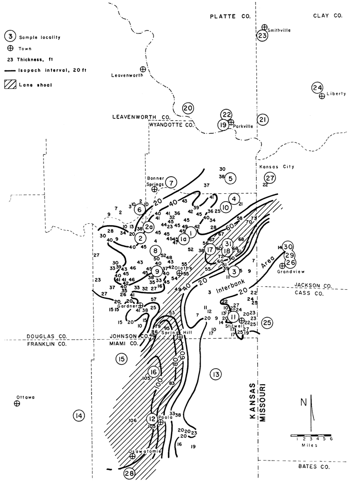
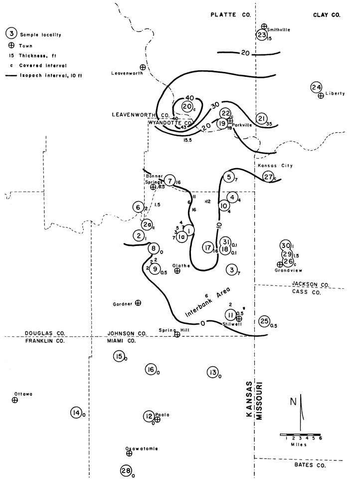
This study focuses on a complex of phylloid algal-carbonate mud banks in the late Pennsylvanian Wyandotte Limestone of Johnson County, Kansas, and the surrounding counties of eastern Kansas and western Missouri (Fig. 1). The bank complex (Fig. 2) occurs in an area about 25 by 65 miles in which the formation ranges from 2 to 103 feet in thickness (Fig. 3). Stratigraphy of the Wyandotte formation in this area has been described by Newell (1935), Jewett and Newell (1935), and Searight and Howe (1961), and also is recorded in several unpublished reports on file at the Kansas and Missouri State Geological Surveys.
Figure 1--Index map of study area showing sample localities and locations of cross sections (shown on Plate 1).
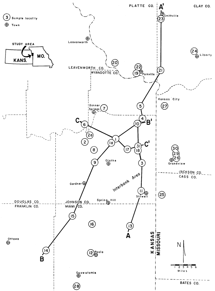
Figure 2--Carbonate bank development in limestone members of the Wyandotte Limestone. Banks tend to form over top of previous banks. Interbank area in southeastern Johnson County was a persistent feature throughout deposition of Wyandotte.
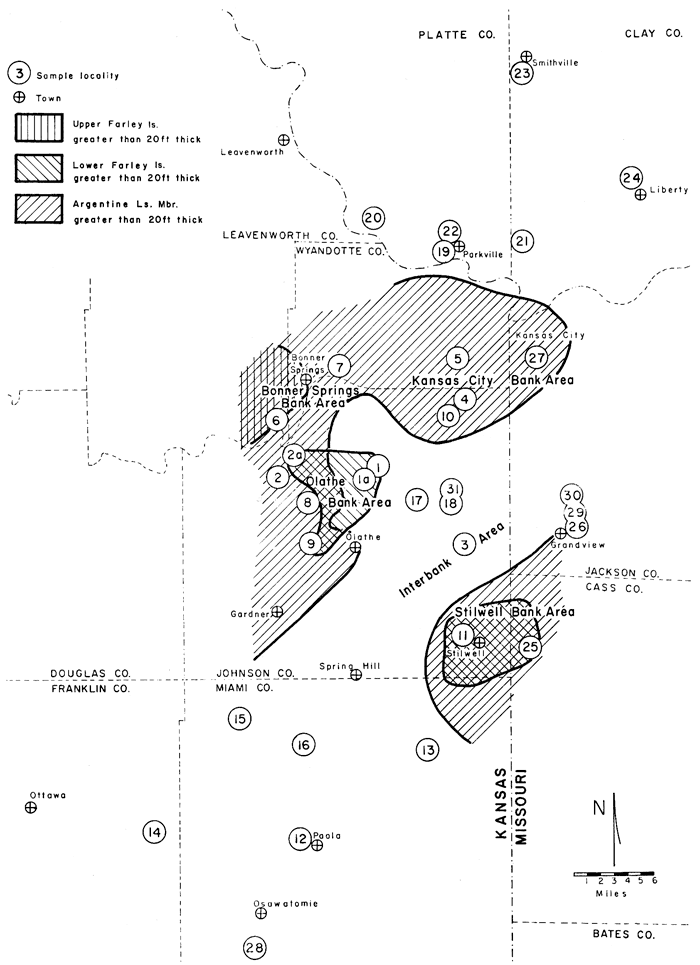
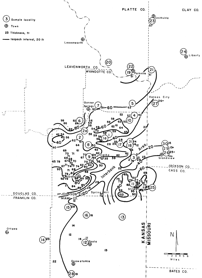
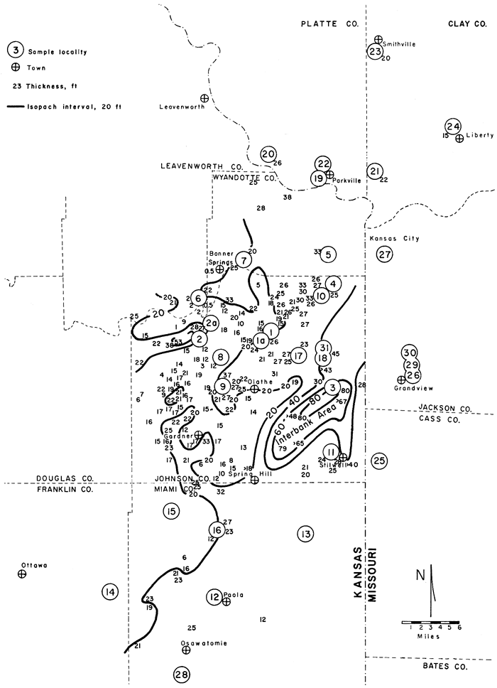
Figure 3--Isopach map of Wyandotte Limestone. Successive bank development has resulted in thickening of Wyandotte on either side of interbank area. Data for Johnson County from maps prepared for publication by H. G. O'Connor, State Geological Survey of Kansas. Outcrop and subsurface information on file at Kansas Geological Survey; other data from present study, Newell (1935), and Jewett and Newell (1935).
The Wyandotte consists of a lithologic suite that is common in the late Paleozoic of the Midcontinent but which has received little paleoenvironmental study. A diagnostic biota, oolites, and abundant primary structures, including cross-stratification, mud cracks, intraclasts, and burrow mottling, distinguish this facies complex. Fresh exposures necessary for this study were found readily in quarries and new road cuts in the area.
I wish to thank Professors Léo F. Laporte, Thomas A. Mutch, and R. K. Matthews, all of Brown University, for encouragement and valuable criticisms throughout research and writing of the doctoral dissertation. Gratitude is expressed also to the following for reviews and criticisms and information at various stages in the preparation of this manuscript: Howard G. O'Connor, Philip H. Heckel, and Doris E. Zeller, all of the State Geological Survey of Kansas, William J. Metzger, of the State University College at Fredonia, N.Y., and other persons at the State Geological Surveys of Kansas and Missouri. Special thanks are due Howard G. O'Connor for helpful discussions and permission to use data from maps in preparation at the State Geological Survey of Kansas.
I gratefully acknowledge financial assistance for field, laboratory, and manuscript-preparation expenses from a National Science Foundation Cooperative Summer Fellowship, the Research Fund of the American Association of Petroleum Geologists, and The Society of the Sigma Xi (RESA Research Fund).
Table 1--Stratigraphic position of Wyandotte Limestone within Pennsylvanian Midcontinent rock succession.
| Pennsylvanian System | ||||||||
| Upper Pennsylvanian Series | ||||||||
| Missourian Stage | ||||||||
| Lansing Group | ||||||||
| Kansas City Group | ||||||||
| Zarah Subgroup | ||||||||
| Bonner Springs Shale | ||||||||
| Wyandotte Limestone | Interval Studied |
|||||||
| Farley Limestone Member | ||||||||
| Upper Limestone Unit | ||||||||
| Middle Shale Unit | ||||||||
| Lower Limestone Unit | ||||||||
| Island Creek Shale Member | ||||||||
| Argentine Limestone Member | ||||||||
| Quindaro Shale Member | ||||||||
| Frisbie Limestone Member | ||||||||
| Lane Shale | ||||||||
The Zarah Subgroup is about 130 feet thick in the Kansas City area where the limestone members of the Wyandotte are prominent. The limestone members thin northward across northwestern Missouri and northeastern Kansas (Burchett, 1959). They pinch out southward in Anderson County, Kansas (Newell, 1935), and westward in the subsurface of Franklin County, Kansas (Parkhurst, 1959). Where the limestones are thinner the Zarah Subgroup is thinner; where they are absent the Lane Shale and the Bonner Springs Shale cannot be differentiated.
The Lane is an arenaceous to argillaceous gray shale that contains a few thin lenses of quartzose sandstone and coal (Newell, 1935; Jewett and Newell, 1935). It is more sandy to the southwest where it is thickest. Coal occurs only in northwestern Missouri where the formation is thin (Searight and Howe, 1961). A few layers rich in marine fossils, mainly crinoids, occur in the Kansas City area.
The thickest part of the Lane extends from western Miami County northeastward across Johnson County (Fig. 4). This thickened portion of the Lane is paralleled on the southeast by an elongate area of thin Lane that coincides with the interbank area (Fig. 2). Subsequent Wyandotte facies development and distribution are related to these thickness irregularities in the Lane.
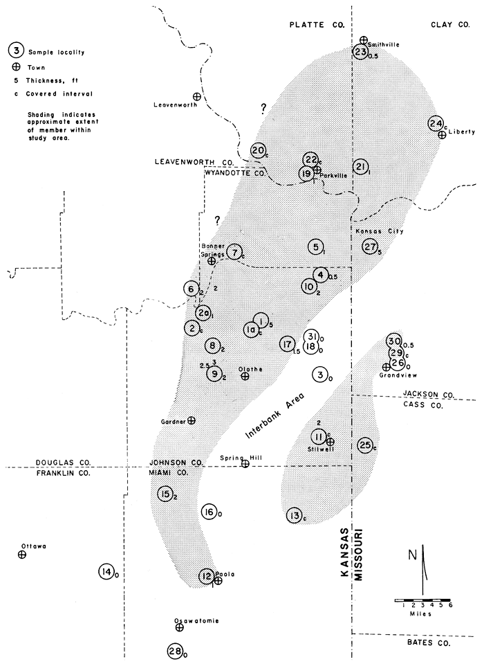
Figure 4--Isopach map of Lane Shale. Thickened part shaded and referred to in text as Lane shoal. Area northwest of shoal is Lane deltaic platform. Note abrupt thinning of shoal southeastward into interbank area. Data sources same as Figure 3.
The Bonner Springs Shale is a gray to buff shale, sandy shale, and sandstone (Newell, 1935; Jewett and Newell, 1935; Searight and Howe, 1961). The sandstone is commonly cross-stratified and occupies channels cut into underlying shale and locally into the top of the Wyandotte. The Bonner Springs is thickest in the interbank area where the Lane Shale and Wyandotte Limestone are thinnest (Fig. 5).
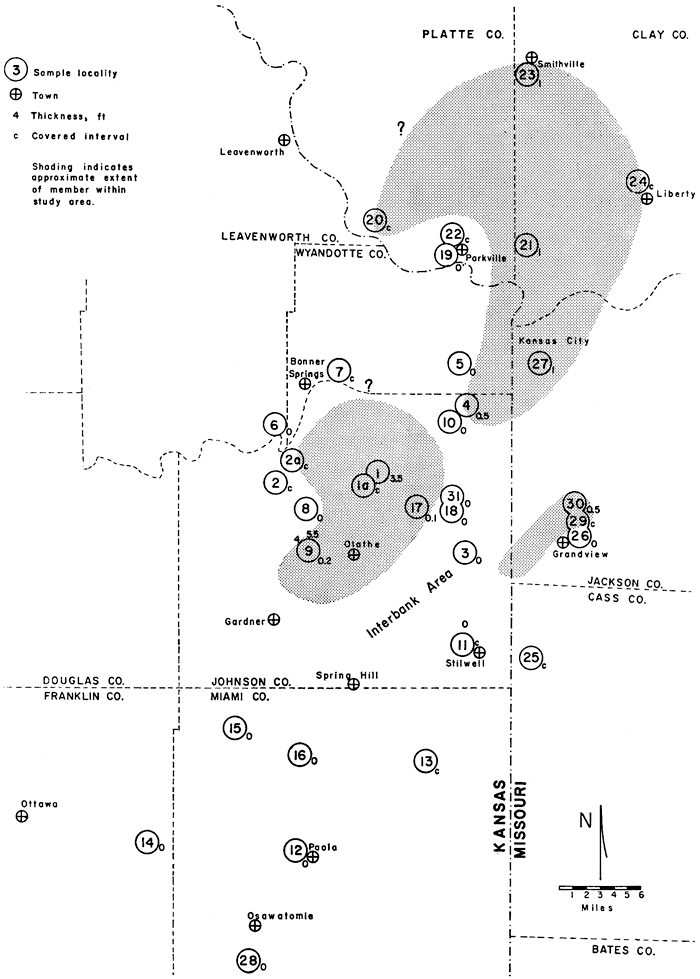
Figure 5--Isopach map of Bonner Springs Shale. Note greater accumulation in interbank area. Data sources same as Figure 3.
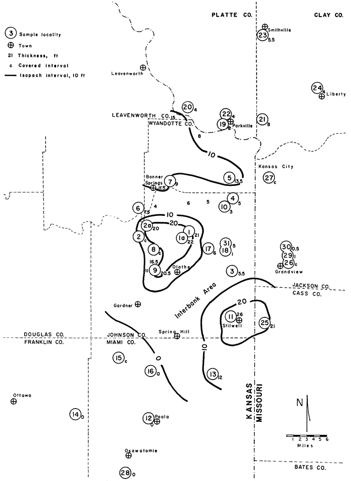
The Frisbie Limestone (Fig. 6) is the lowest member of the Wyandotte at most localities within the study area. It typically stands out above the Lane Shale as one or two massive beds totaling 5 feet or less in thickness (Fig. 9, B). This Member is not present in the interbank area or at the southern margin of the study area.
Figure 6--Thickness and distribution of Frisbie Limestone Member. Note absence of Frisbie in interbank area. Data from this study only.
The Quindaro Shale (Fig. 7) is 3.5 feet or less in thickness and has a limited distribution in this area, although it is identified in areas farther north where the lower part is black fissile shale (Burchett, 1959). The Quindaro is absent in parts of Wyandotte County, in the interbank area, and south of Olathe.
Figure 7--Thickness and distribution of Quindaro Shale Member. In interbank area Quindaro is not distinguished because Frisbie Limestone is absent. Data from this study only.
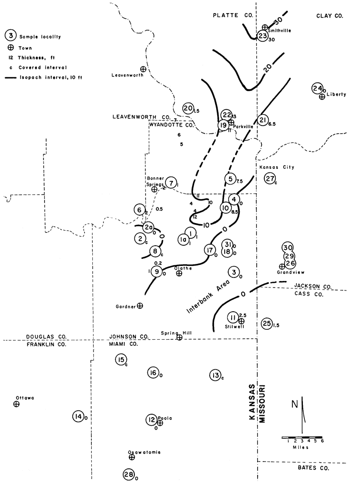
The Argentine (Fig. 8) is the main limestone of the Wyandotte and shows great variation in thickness within the study area. Bank development in the Argentine attains about 20 feet in the Kansas City and Olathe areas (Fig 9, B) and as much as 50 feet at Stilwell, Kansas. In contrast, this Member thins abruptly to 7 feet in the interbank area.
Figure 8--Isopach map of Argentine Limestone Member. Note thickened areas at Kansas City and Olathe-Bonner Springs separated from thickened area at Stilwell by thinner interbank area. Data from present study, Newell (1935), and Jewett and Newell (1935).
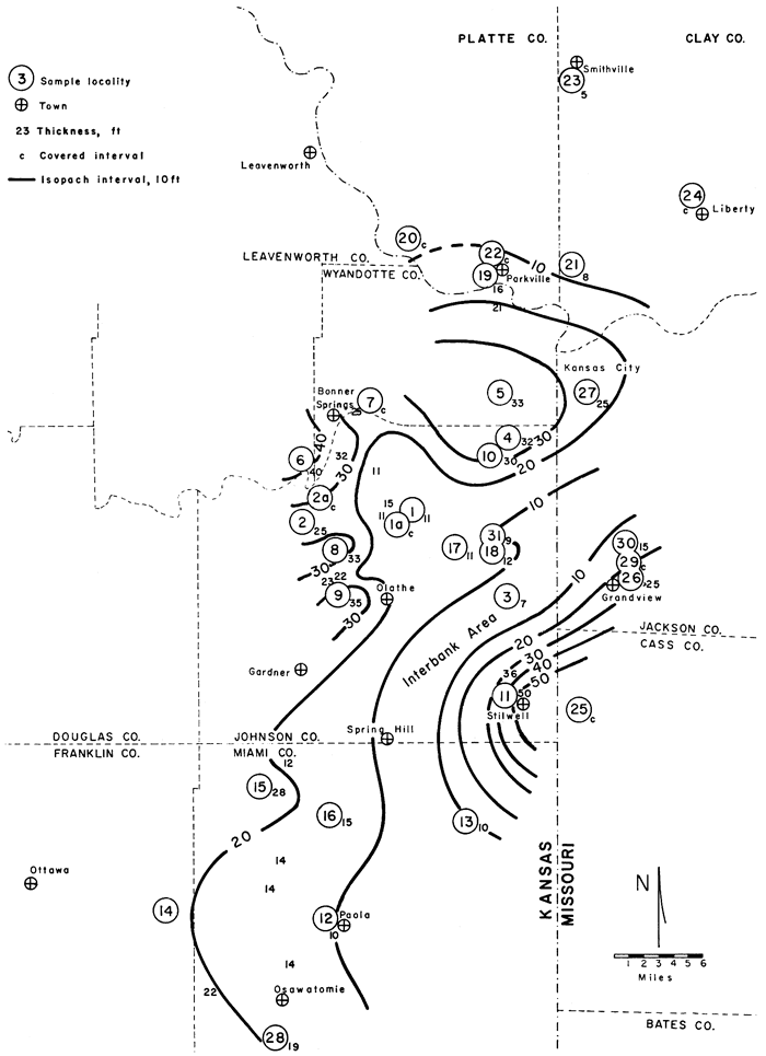
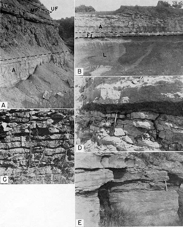
Figure 9--Field views of members of the Wyandotte Limestone. A, Argentine Limestone (A); Island Creek Shale (IC), here 18 feet thick; lower Farley Limestone (LF); middle Farley shale (MF); and upper Farley limestone (UF) in nonbank area. Locality 19. B, Lane Shale (L); massive Frisbie Limestone (Fr), 2 feet thick; Quindaro Shale, 0.2 foot thick and not visible; Argentine Limestone (A), 35 feet exposed in Olathe bank area. Locality 9. C, Wavy-bedded Argentine Limestone in which thin, dark shale partings have weathered back from the outcrop. Locality 28. D, Thin, fusulinid-rich Island Creek Shale (at hammer head) underlain by Argentine Limestone and overlain by lower Farley limestone in Stilwell bank area. Locality 11. E, Cross-stratified oolite facies of lower Farley. Locality 21.
A lobe of Island Creek Shale (Fig. 9, A) extends southward from northern Wyandotte County between areas of the underlying thickened Argentine (Fig. 10). This shale thickens slightly in the interbank area and thins above all thick parts of the Argentine (Fig. 9, D).
Figure 10--Isopach map of Island Creek Shale Member. Note lobe of underlying Argentine extending southward from Wyandotte County between Kansas City and Olathe-Bonner Springs bank areas. Data source same as Figure 8.
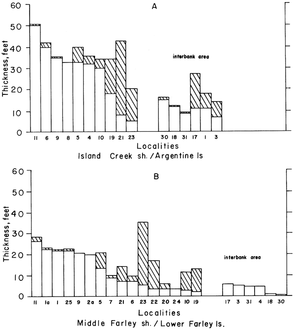
Thickness of the Island Creek Shale complements the thickness of the underlying Argentine Limestone, in that the shale is thickest where the limestone is thin except in the interbank area (Fig. 11, A). Thus, Argentine topography probably controlled deposition of the Island Creek to some extent. Incomplete thickness compensation may be due to several factors: (1) greater differential compaction of shales, (2) partial subsidence of thick carbonate areas before shale deposition, and (3) incomplete filling of depressions by shale, particularly in the interbank area.
Figure 11--Thickness of two Wyandotte shales compared with underlying limestones. A, Thickness of Island Creek Shale Member (diagonally ruled) tends to complement thickness of underlying Argentine Limestone except in interbank localities. B, Thickness of middle Farley shale (diagonally ruled) also tends to complement thickness of underlying lower Farley limestone except in interbank localities. Because upper Farley limestone is absent in interbank localities, shale immediately above lower Farley limestone is mapped as next higher shale (Bonner Springs), although it may be equivalent to middle Farley shale.
Lower limestone unit--Two areas where this limestone unit is thick occur directly above the thickened Argentine at Stilwell and Olathe (Fig. 12). In other areas the lower Farley is thin.
Figure 12--Isopach map of lower part of Farley Limestone Member. Unit thickens above Argentine bank development in Stilwell and Olathe areas. Data source same as Figure 8.
Middle shale unit--The middle Farley (Fig. 9, A) is a less clearly defined shale lobe that extends southward from Missouri (Fig. 13). Like the Island Creek Shale Member, the middle Farley shale also tends to complement the thickness of the underlying limestone unit (Fig. 11, B). Although Figure 13 shows 0 thickness for the middle Farley shale in the interbank area, the lower 7 to 8 feet of the Bonner Springs Shale in this area is thought to be the lateral equivalent of the middle Farley shale.
Figure 13--Isopach map of shale in middle of Farley Limestone Member. Lobe extends southward from Platte County on cast side of lower Farley bank area at Olathe. Middle Farley shale not differentiated in interbank area, but 7 or 8 feet of basal Bonner Springs formation there may be equivalent. Data source same as Figure 8.
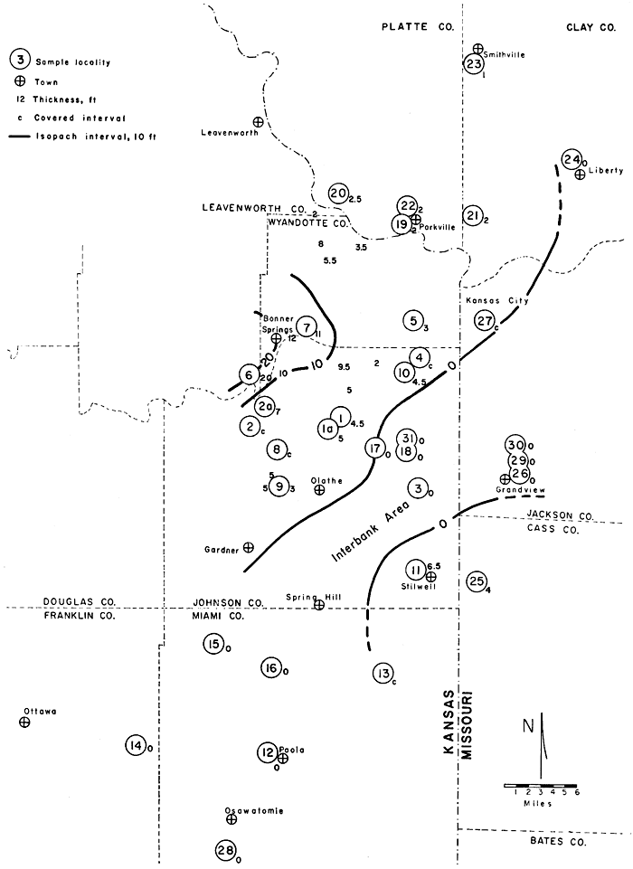
Upper limestone unit--This uppermost limestone unit of the Wyandotte (Fig. 9, A) is relatively thin (Fig. 14), except in the Bonner Springs area, where it is 20 feet thick. Absence of this limestone unit in the interbank area may be due to erosion because channel sandstones in the Bonner Springs Shale have been observed to cut down into the lower Farley limestone at Locality 31 in the interbank area as well as just east of Locality 11 in the Stilwell bank area.
Figure 14--Isopach map of upper part of Farley Limestone Member. Unit thick only around Bonner Springs and may have been eroded in interbank area. Data source same as Figure 8.
North of the interbank area the Frisbie Limestone Member typically is separated from the next higher limestone (Argentine Member) by the thin Quindaro Shale Member (Fig. 6 and 7) and is thus relatively easy to map. In this area the Frisbie is lithologically distinct from most of the Argentine Limestone Member. Recognition of the Frisbie becomes difficult to the south where the Quindaro Shale is absent and lithologic distinction from the Argentine is less marked. The Frisbie probably is absent in the interbank area where the Quindaro Shale is not distinguishable, and the basal layers of the Wyandotte resemble the Argentine (see Pl. 1).
The sequence of banks at Stilwell is separated from other algal banks to the north and west by the interbank area. Lack of outcrop and subsurface control makes it difficult to trace members across the interbank area, where they undergo rapid thinning and lithologic change. However, vertical succession and facies relationships of the sequence at Stilwell correlate well with the members of the Wyandotte Limestone at Olathe. This suggests that perhaps similar lithologies developed at the same time on both sides of the interbank area in which a different and thinner lithologic sequence was deposited.
The lower 7 or 8 feet of Bonner Springs Shale in the interbank area, where the upper Farley limestone is missing, is thought to correlate with the middle Farley shale to the north (Cross section A-A', Pl. 1). At Locality 31 a channel sandstone in the Bonner Springs cuts down through about 7 feet of gray shale that overlies the lower Farley limestone. This dark-gray shale closely resembles the middle Farley shale at Locality 10 a few miles to the north and is distinct from the light-gray to buff, sandy shales of the lower Bonner Springs in this area. The dark-gray shale at Locality 31 is overlain by a 6-inch layer of limestone-pebble conglomerate which might represent the erosional product of the upper Farley. This shale, therefore, is considered to be correlative with the middle Farley shale.
Approximate locations are shown in Figure 1. Lithologic type of selected samples is given in Table 4, and stratigraphic position of samples is shown on Plate 1.
| 1. | S line of SE SE SW sec. 25, T 12 S, R 23 E, Johnson County, Kansas. Road cut on south side of new county road. Complete Wyandotte section. |
| 1a. | E NE sec. 1, T 13 S, R 23 E, Johnson County, Kansas. Railroad cut 1 mile southeast of Craig. Upper part of Island Creek Shale Member and Farley Limestone Member. |
| 2. | NW NW NW sec. 1, T 13 S, R 22 E, Johnson County, Kansas. Quarry in northwest bluff of Camp Creek. Argentine Limestone Member, Island Creek Shale Member, and lower Farley limestone. |
| 2a. | SW NE sec. 25, T 12 S, R 22 E, Johnson County, Kansas. Both sides of east-west road cut (K-10). Complete Wyandotte section. |
| 3. | West end of line between sec. 30 and sec. 31, T 13 S, R 25 E, Johnson County, Kansas. Road cut (K-150) 30,0 yards west of intersection of old U.S. Highway 69. Complete Wyandotte section. |
| 4. | NE NE NW sec. 4, T 12 S, R 25 E, Johnson County, Kansas. Road cut along 18th Street Expressway. Complete Wyandotte except for upper part of Farley Limestone Member. |
| 5. | Composite section from SW NW NE and E SE NE sec. 29, T 11 S, R 25 E, Wyandotte County, Kansas. Former is abandoned quarry and latter is road cut on 18th Street Expressway. Complete Wyandotte section. |
| 6. | SW NE SW sec. 14, T 12 S, R 22 E, Leavenworth County, Kansas. Loring Quarry. Acetate peels of core furnished by S. M. Ball, State Geological Survey of Kansas. Complete Wyandotte Section. |
| 7. | NE SE NE sec. 28, T 11 S, R 23 E, Wyandotte County, Kansas. Road cut along north side of Camp Naish entrance road. Upper part of Argentine Limestone Member, Island Creek Shale Member, and Farley Limestone Member. |
| 8. | SE SE sec. 7, T 13 S, R 23 E, Johnson County, Kansas. South side of east-west road up bluff of Cedar Creek. Complete Wyandotte section. |
| 9. | NE NE sec. 32, T 13 S, R 23 E, Johnson County, Kansas. Along north side of New Olathe Lake spillway, 2.2 miles west of Olathe. Complete Wyandotte section. |
| 10. | SE SW SE sec. 12, T 12 S, R 24 E, Johnson County, Kansas. Road cut and creek bed at intersection of U.S. Highway 50 and Turkey Creek Expressway. Complete Wyandotte section. |
| 11. | SW SE sec. 3 1, T14 S, R 25 E, Johnson County, Kansas. Quarry 0.3 mile west of old U.S. Highway 69. Acetate peels of core furnished by S. M. Ball, State Geological Survey of Kansas. Complete Wyandotte section. |
| 12. | NE SE SE sec. 18, T 17 S, R 23 E, Miami County, Kansas. West side of road cut. Complete Wyandotte section. |
| 13. | NE NW sec. 14, T 16 S, R 24 E, Miami County, Kansas. Abandoned quarry. Complete Wyandotte except for upper Farley limestone. |
| 14. | SW SW SW sec. 9, T 17 S, R 21 E, Franklin County, Kansas. Road cut. Complete Wyandotte section. |
| 15. | SW sec. 33, T 15 S, R 22 E, Miami County, Kansas. Road cut on south bluff of Rock Creek. Frisbie and Argentine limestones exposed. |
| 16. | SE NW SW sec. 8, T 16 S, R 23 E, Miami County, Kansas. Abandoned quarry. Complete Wyandotte section. |
| 17. | SW SW SW sec. 10, T 13 S, R 24 E, Johnson County, Kansas. Stream bed. Complete Wyandotte section. |
| 18. | NE NE NE sec. 13, T 13 S, R 24 E, Johnson County, Kansas. South side of road cut. Complete Wyandotte section. |
| 19. | SE NE sec. 34, T 51 N, R 34 W, Platte County, Missouri. Abandoned quarry 0.5 mile west of Parkville. Complete Wyandotte section. |
| 20. | SE NW SE sec. 14, T 51 N, R 35 W, Platte County, Missouri. Road cut 0.3 mile north of Waldron. Farley Limestone Member. |
| 21. | Composite section from sec. 33, 34, 27, 22, T 51 N, R 33 W, Platte and Clay counties, Missouri. Road cuts along U.S. Highways 169 and 71. Complete Wyandotte section. |
| 22. | NW NE NW sec. 26, T 51 N, R 24 E, Platte County, Missouri. Road cut on south side of route 45. Farley Limestone Member. |
| 23. | SE SE SE sec. 22, T 53 N, R 33 W, Clay County, Missouri. Road cut along U.S. Highway 169. Complete Wyandotte section. |
| 24. | NW NE sec. 1, T 51 N, R 32 W, Clay County, Missouri. Road cut in north-bound lane of U.S. Highway 69 near intersection of U.S. Highway 71. Farley Limestone Member. |
| 25. | SW SW SW sec. 28, T 15 S, R 33 W, Cass County, Missouri. Railroad cut under bridge. Upper Argentine Limestone, Island Creek Shale, and Farley Limestone mem- bers. |
| 26. | W NW NW sec. 13, T 47 N, R 33 W, Jackson County, Missouri. Road cut along U.S. Highway 71. Argentine Limestone Member. |
| 27. | SW sec. 8, T 49 N, R 33 W, Jackson County, Missouri. Road cut along Maine Street and intersection of 27th Street. Frisbie Limestone, Quindaro Shale, and Argentine Limestone members. |
| 28. | SW sec. 22, T 18 S, R 22 E, Miami County, Kansas. Road cut on U.S. Highway 169, 1 mile southwest of intersection of K-7. Complete Wyandotte section. |
| 29. | W sec. 12, T 47 N, R 33 W, Jackson County, Missouri. Road cut along U.S. Highway 71 under Blue Ridge Extension overpass. Upper Argentine and Island Creek Shale members and lower Farley limestone. |
| 30. | E sec. 2, T 47 N, R 33 W, Jackson County, Missouri. Road cut along 110th Street exit from northbound lane of U.S. Highway 71. Complete Wyandotte except for upper Farley limestone. |
| 31. | SE sec. 7, T 13 S, R 25 E, Johnson County, Kansas. Road cut along Interstate Highway 435. Complete Wyandotte except for upper Farley limestone. |
About 40 outcrops of the Wyandotte Limestone were examined and 33 exposures were measured, described in detail, and sampled (Fig. 1; Pl. 1). Where possible, the formations adjacent to the Wyandotte were described and measured. Outcrop correlations were checked in the field and were supplemented by subsurface data on file at the State Geological Survey of Kansas.
Limestones were sampled at various intervals, depending upon frequency of lithologic change. The samples were taken a few inches apart where rock types are thin and at approximately 5-foot intervals in thicker, more homogeneous units, particularly within the algal-bank facies. Numerous large specimens were collected for better definition of fossil-rock relationships and primary structures and were slabbed to about a 4" x 6" surface. Shale units in the Wyandotte were sampled at about 5-foot intervals. The top of the underlying Lane Shale and the bottom of the overlying Bonner Springs Shale were sampled for comparison with the Wyandotte shales.
Limestone specimens were slabbed, polished, etched with dilute HCl, and acetate peels were prepared. Selected samples were thin-sectioned. Several vertical and horizontal cuts were made in certain specimens to determine more exactly the orientation of algal blades and primary structures. Thin sections were stained with alizarin red-S for definition of dolomite. Negative peel-prints of all peels and negative prints of thin sections were made for visual comparison of lithology and fossil content. Samples were not point-counted because meaningful lithologic differences were clearly established by visual estimate. Limestones were described using the terminology of Folk (1959) (see Table 4, p. 37). Shale samples were boiled and the clay fraction decanted to obtain the fossil residue.
Generic identification of fossils was made only through use of the paleontologic literature and thus are subject to revision by specialists. General categories such as "productids" and "crinoids" are used because more refined distinction within such groups is not possible in thin section. Relative abundance of the biota in each facies was estimated from polished slabs, thin sections, and photographs, and is summarized in Table 2.
Table 2--Biota of each facies in the Wyandotte Limestone. R = rare; C = common, A = abundant.
| Organism | Facies | ||||||||
|---|---|---|---|---|---|---|---|---|---|
| Terrigenous | Stromatolite- sponge |
Algal-bank | Archaeolith- ophyllum cap |
Calcarenite | Oolite | Shely mud | |||
| Phyllold algae | |||||||||
| Archaeolithophyllum | |||||||||
| missouriense | C | R-C | A | A | R | ||||
| lamellosum | A | ||||||||
| Anchicodium | C | A | |||||||
| Other | R | ||||||||
| Epimastopora | R | ||||||||
| Stromatolitic algae | |||||||||
| crusts | A | ||||||||
| Osagia | R | C-A | R | C | |||||
| Foraminifers | |||||||||
| Calcitornellid | C | R | R | ||||||
| Tetrataxid | C | R | |||||||
| Triticites | R-A | R-C | |||||||
| Calcisponges | C | R | |||||||
| Lophophyllid corals | R | R | R | ||||||
| Bryozoans | |||||||||
| fenestrate | C | C | C | C-A | R | C-A | |||
| ramose | C | C | C | C | R | C | |||
| encrusting | C | C | |||||||
| Brachiopods | |||||||||
| Productids | C | C | C-A | C | R | C | |||
| Composita | C | C | C-A | C | C | R | C | ||
| Punctospirifer | C | C | C | R | R | ||||
| Neospirifer | C | R | R | ||||||
| Hustedia | C | C | C | ||||||
| Enteletes | R-C | ||||||||
| Ambocoelia | R | ||||||||
| Mollusks | |||||||||
| Gastropods | C | C | C | C | C | R | C | ||
| Pelecypods | R | C-A | C | R-C | |||||
| Cephalopods | R | R | |||||||
| Arthropods | |||||||||
| Trilobites | R | R | R | R | R | ||||
| Ostracodes | R | R | R | R | R | ||||
| Echinoderms | |||||||||
| Crinoid ossicles | A | A | A | A | C | C | |||
| Echinoid spines | R | R | R | R | R | ||||
| ?Burrowing organisms | C-A | C | C | C | C | C | |||
Next page--Facies, Conclusions, References
Kansas Geological Survey, Algal-Bank Complex in Wyandotte Limestone
Placed on web March 30, 2009; originally published in Nov. 1969.
Comments to webadmin@kgs.ku.edu
The URL for this page is http://www.kgs.ku.edu/Publications/Bulletins/198/index.html