Kansas Geological Survey, Bulletin 14, originally published in 1928
Prev page--Start of Report
The only deposit of volcanic ash known in Comanche County is in the northern part about 1 mile north of the town of Wilmore. Here about 6 feet of ash crops out along the side of a hill in a pasture. What is probably the same deposit is exposed about 200 feet eastward on the west side of a small valley. One to 2 feet of soil overburden covers the deposit, while the lower contact is not exposed. The ash is extremely cross-bedded. It is greyish white in color and contains a few medium-sized lumps. The following textural analysis shows it to be of medium fineness:
| Over 20 mesh |
20 to 100 mesh |
100 to 200 mesh |
200 to 300 mesh |
Under 300 mesh |
Index | Rank |
|---|---|---|---|---|---|---|
| 1% | 27% | 39% | 19% | 14% | 133 | 27 |
This deposit has not yet been opened up. It is not of a great size, but because of the short haul to the railroad at Wilmore it holds promise of eventually being developed.
Two deposits of volcanic ash are reported from Decatur County. One of these is on the Lem Gillette farm southwest of Oberlin, in the southwest quarter of sec. 8, T. 4 S., R. 29 W. This ash is very definitely of Tertiary age. It crops out in several places along a northward-sloping draw and its tributaries and is in every instance lying under a "mortar bed." The ash is light bluish gray in color and very compact. Because of the superior hardness of the overburden the latter slightly overhangs the outcropping ash. About 4 feet of ash is exposed. In spite of its compact character it was readily broken down and proved to have an unusually high percentage capable of passing through the 200- and 300-mesh screens. The analysis follows:
| Over 20 mesh |
20 to 100 mesh |
100 to 200 mesh |
200 to 300 mesh |
Under 300 mesh |
Index | Rank |
|---|---|---|---|---|---|---|
| 0.6% | 13% | 23% | 35% | 28% | 205 | 7 |
However, it is doubtful if this ash could ever be considered a commercial proposition, due to the presence of the overlying rock.
A similar deposit is reported to occur in section 12 of the next township to the west on the farm of Hjalmer Alstron. This was not visited by the writer.
There are at least two deposits of volcanic ash known to occur in Ellsworth County. One of these is located 2 to 3 miles east of Kanopolis, adjoining the Union Pacific right of way. This was not visited by the writer. The other deposit is located on the Hudson place, about 2 miles east and 7 miles south of Kanopolis. The ash crops out at the top of a high bluff on the southeast side of a northeastward-flowing stream. The outcrop is 100 feet long with a maximum thickness of 13 feet. This prominent exposure of dazzling white ash is easily visible from points some distance westward and northward. However, it is believed that in spite of the large outcrop the tonnage is not great, for ash does not appear across the ridge a short distance eastward. The overburden varies from nothing to 2 feet and consists of soil with a few pebbles. The upper 3 feet of ash contains a number of clay partings, but the next 4 feet is of good grade. The lower portion of the ash bed was covered by slumped material and could not be tested. The deposit overlies the Dakota sandstone. Because of its white color and unconsolidated condition it is undoubtedly of Pleistocene age.
The sample collected was light gray and very free from lumps. It proved to be of good grade texturally, for over half passed through the 200-mesh screen, and 13 per cent was finer than 300-mesh. The screen analysis follows:
| Over 20 mesh |
20 to 100 mesh |
100 to 200 mesh |
200 to 300 mesh |
Under 300 mesh |
Index | Rank |
|---|---|---|---|---|---|---|
| 0.1% | 7% | 41% | 39% | 13% | 171 | 13 |
Due to its distance from the railroad and probable small size, a profitable exploitation of this ash is questionable. However, the deposit is under lease and the attempt may be made to market the material.
The only known deposit in Gove County is located about 10 miles southwest of Quinter in the northeast quarter of the southwest quarter of sec. 21, T. 13 S., R. 26 W. It occurs on the east side of a southward-flowing tributary of Hackberry creek. The ash forms a glistening white bluff for a short distance, overlying the Smoky Hill chalk formation. The maximum thickness exposed is 14 feet with an overburden of soil and pebbles varying in thickness from 1 to 5 feet. The deposit is claimed to increase in depth back into the hill to the eastward. The bottom four feet of the exposed ash is gray in color and feels clayey. About midway between the top and bottom contact are a number of discoidal concretions.
The ash above the clayey lower portion is grayish white in color and fairly free from lumps. The screen analysis of this material follows:
| Over 20 mesh |
20 to 100 mesh |
100 to 200 mesh |
200 to 300 mesh |
Under 300 mesh |
Index | Rank |
|---|---|---|---|---|---|---|
| 0.5% | 2% | 26% | 40% | 32% | 233 | 6 |
The ash is unusually fine, with 72 per cent passing through the 200-mesh screen. Although by no means of the same quality, the lowermost 4 feet of ash is still of better textural grade than many other deposits. Its analysis follows:
| Over 20 mesh |
20 to 100 mesh |
100 to 200 mesh |
200 to 300 mesh |
Under 300 mesh |
Index |
|---|---|---|---|---|---|
| 0.1% | 3% | 34% | 53% | 10% | 180 |
It would be quite possible to mine and market this lowermost 4 feet along with the other material.
It has been estimated that this deposit contains 60,000 tons of volcanic ash. The maximum thickness is reported to be 16 feet, but this dimension tapers to the north and south. About fifteen years ago this property was opened up and seven cars were shipped. It is now inactive, however, and will doubtless remain so until other Kansas deposits closer to transportation facilities are exhausted.
Only one deposit is known in Graham County. This is situated in the western part of the County 1 1/2 miles north of the west edge of the town of Morland. It is owned by M. L. Mitchell, of Tulsa, Okla. The ash crops out on the north side of a large draw and on the western side of a tributary draw. Volcanic ash thrown out by a gopher was also found on the east side of the tributary draw. The size of the deposit is not known, but it is probably not very great. The outcrop is 40 feet wide and the maximum height 9 feet. Both the depth into the hill and the lateral extent beyond the gopher hole across the tributary draw are unknown. The ash grades into loess at the sides and on the top. A thin veneer of gravel covers the deposit.
The ash itself is of exceptionally fine quality. It is grayish white in color and contains no lumps. The analysis follows:
| Over 20 mesh |
20 to 100 mesh |
100 to 200 mesh |
200 to 300 mesh |
Under 300 mesh |
Index | Rank |
|---|---|---|---|---|---|---|
| 0.4% | 2% | 12% | 36% | 50% | 283 | 2 |
This is next to the finest of the ash deposits examined, with 50 per cent passing through the 300-mesh screen. Because of its quality and the short haul necessary to the railroad at Morland this deposit is well worth prospecting to determine if its size is sufficient to warrant exploitation.
There are at least four deposits of volcanic ash in Grant County, but only two of these were visited by the writer. They are all located in the southeast corner of the county in T. 30 S., R. 35 W. The nearest town is Satanta, which lies a few miles east in Haskell County. Only one of these deposits has been opened commercially. This is known variously as the Western Spar Products Company and the Dodge City Spar Company mine in the northwest quarter of section 24. This mine was formerly connected with the Santa Fe railroad by a narrow-gauge spur running north from what is known as Spar Siding. The tracks have been recently pulled up. The deposit lies on the north side of a large valley. It averages 9 feet thick with an overburden of 1 to 4 feet. The latter consists of loess and sand with occasional lime pebbles. Some of the ash may have been water-lain, but most of it is in wind-blown dunes as is the sand overburden. The ash is of exceptional quality. It is gray and free from lumps. The screen analysis follows:
| Over 20 mesh |
20 to 100 mesh |
100 to 200 mesh |
200 to 300 mesh |
Under 300 mesh |
Index | Rank |
|---|---|---|---|---|---|---|
| 0.2% | 5% | 18% | 25% | 52% | 276 | 3 |
Although not at present in operation, this deposit has produced several thousand tons, while the remaining ash has been estimated at about 15,000 tons. The workings consist of a large pit covering several acres. It is reported that the company had a mill in Dodge City, which was condemned on account of the dust produced.
Another deposit occurs three-tenths of a mile east. It is opened up by a shallow pit about 15 feet wide and 20 feet long. The overburden is 4 feet. This may be the deposit owned by the Pumicite Company, and reported to contain 60,000 tons of ash. To the northwest, in the northwest quarter of section 17, is a deposit owned by C. D. Hickok, of Ulysses, Kari. The owner's description follows: "I do not know how large in area or depth this deposit is, but I estimate that it covers about 80 acres and that it may have a depth of from 8 to 14 feet." In the northwest corner of the township, in the north half of the southwest quarter of section 6, is a deposit of unknown size. It is owned by Charles P. Metcalf, of Lawrence, Kan. Discovery was made by means of ash thrown out of a badger hole. Neither of the last two deposits was visited by the writer.
Plate II--A, Volcanic ash in Western Spar Products mine, southeastern Grant County.
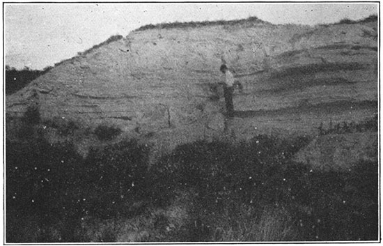
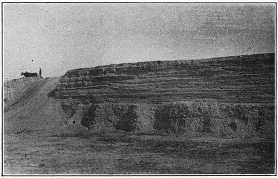
Plate II--B, Volcanic ash and overburden, Cudahy mine, Meade County.
N. W. Bass (1926) has described the following occurrences of "Volcanic ash in southern Hamilton County: "A bed 1 1/2 feet thick .occurs near the east quarter corner of sec. 20, T. 26 S., R. 41 W. It is at least 1 1/2 feet thick in the southwest quarter of the southwest quarter, sec. 22, and 2 1/2 feet thick near the center of sec. 13, T. 26 S., R. 41 W., where it is extensively exposed. Other exposures occur in the southeast quarter of the southeast quarter of sec. 1, T. 26 S., R. 42 W.; southwest quarter of sec. 28; the southeast quarter of sec. 14, T. 26 S., R. 41 W., and the northeast quarter of sec. 29, T. 26 S., R. 40 W." The largest one of these, the one occurring in sec. 13, T. 26 S., R. 41 W., was visited by the writer. It consists of a massive ledge of compact white volcanic ash. The exposure on the side of the draw is about 70 feet long and about 2 1/2 feet thick. The ash runs back into the hill under overburden consisting of soil and quartz pebbles. Soil likewise underlies the volcanic ash bed for a distance of about 2 feet where appears the top of the Dakota sandstone.
Because of its white color and associations this ash is probably of Pleistocene age. However, it differs from most of the other Pleistocene ash deposits in that the material is very compact and breaks off into slabby layers. The conclusion is that it was deposited in water. A shallow lake at one time existed here, into which ash both fell from the air and was blown from the surrounding land. The water settling made a much more compact deposit than is usually the case.
Because of its lumpy character the samples collected from Hamilton County had to be crushed before screening. The material proved to be the coarsest studied, giving an index number of 61. Only 9 per cent went through the 200-mesh screen and only 2 per cent through the 300-mesh screen. The complete analysis follows:
| Over 20 mesh |
20 to 100 mesh |
100 to 200 mesh |
200 to 300 mesh |
Under 300 mesh |
Index | Rank |
|---|---|---|---|---|---|---|
| 13% | 39% | 39% | 7% | 2% | 61 | 37 |
Due to the compact condition of the ash, the small size of the deposit and its inaccessibility in regard to railroad transportation neither this deposit or any others so far found in Hamilton County can be considered as having commercial possibilities.
There are two known deposits of volcanic ash in this county. Both occur about 2 miles east of Anthony. The larger one is owned by the Pumicite Company. It is located a short distance south of state highway No. 44 and north of the Kiowa-Hartner branch of the Missouri Pacific railroad, with which a short spur connects. The deposit is basin-shaped with the maximum thickness 6 feet. The overburden is 2 to 3 feet thick and consists of red soil with a scattering of pebbles. The bottom of the deposit is marked by a zone of concretions. The ash is yellow in color and lumpy. Impurities present are iron, clay, and calcium carbonate. All three of these substances may act as binders, producing the lumpy condition. The sample collected by the writer gave an extremely poor screen analysis, with only 2 per cent passing through the 300-mesh screen. The analysis follows:
| Over 20 mesh |
20 to 100 mesh |
100 to 200 mesh |
200 to 300 mesh |
Under 300 mesh |
Index | Rank |
|---|---|---|---|---|---|---|
| 3.5% | 42% | 41% | 12% | 2% | 73 | 36 |
The material caught on the 100-mesh screen consisted of many small aggregates which when broken down by proper milling would increase the percentages of finer ash. This was the poorest commercial ash analyzed by the writer, but he has been informed that since his visit to the deposit a better grade of material has been uncovered.
This deposit was opened up in 1926 and produced a small tonnage during that year. The overburden is scooped to one side and the ash picked up by two wheeler scrapers pulled by tractors. Additional equipment includes a suction fan mounted on a wagon and operated by a Ford engine which sucks up the dry ash. This has not proven very successful. The wheeler scrapers are pulled to the near-by mill and the ash dumped into a bin. A traveling link chain picks up the ash from the bottom of the converging sides of the bin and delivers it to another chain which carries it to the top of the mill. The reputed capacity of the mill is two tons an hour. In the summer of 1927 twelve men were employed on the property. The ash is dried by passing it through a rotating cylindrical dryer. This machine burns oil, and is inclined at such an angle that the ash works down from the upper to the lower end as it is being dried. When the mill was visited by the writer the ash from the drier was elevated to the top of the mill and blown out over a series of bins by a draft of air. The coarsest material fell first and was rejected. Following the reject bin there were three bins which collected successively finer material. The contents of these bins were marketed as different grades. Some of the ash was sacked in 40-pound paper bags, and the remainder went into 100-pound burlap bags with paper liners. Because of the spur it is possible to load directly from the mill into the car. One car holds from 1,500 to 3,000 of the 40-pound bags. The air separation was not completely successful so it has been abandoned and mechanical screens are now used instead.
The second deposit is very much smaller and lies a few feet east of the Pumicite Company property on both sides of the highway. It has not yet been opened up commercially. Both of these deposits are of Pleistocene age.
Plate III--A, Strip pit in volcanic ash near Anthony, Kan.
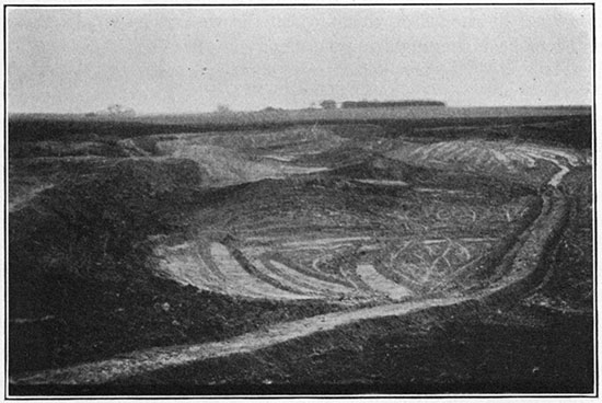
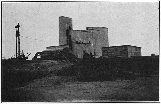
Plate III--B, Mill of Pumicite Company, Anthony, Kan.
Only one deposit has been reported from this county and that was not visited by the writer. It is owned by F. E. Murphy, of Sublette, and is located in the southeast quarter of sec. 19, T. 30 S., R. 34 W. This is in the southwest corner of the county, and it is but a short distance westward to the Western Spar Products Company mine in southeastern Grant County. The Murphy deposit was discovered by means of volcanic ash thrown out by a gopher. It has never been thoroughly prospected.
The Pumicite Company has record of about thirty deposits of volcanic ash in Jewell County. Although none of these are as yet developed the total tonnage probably lies between three and four million. The deposits. visited by the writer were located 3 miles north and from 1 1/2 to 3 1/2 miles west of the town of Burr Oak. They will be described from east to west. On the north side of the section line road, 3 miles north and a little over a mile west of Burr Oak, a large deposit crops out in a cornfield. From the patches of white visible here and there it is obvious that the deposit must cover a good many acres. In one place the plow has thrown out several pure chunks of grayish white ash. A textural analysis of this material follows:
| Over 20 mesh |
20 to 100 mesh |
100 to 200 mesh |
200 to 300 mesh |
Under 300 mesh |
Index | Rank |
|---|---|---|---|---|---|---|
| 0.08% | 16% | 37% | 35% | 12% | 155 | 18 |
The thickness of the deposit at this point is unknown, but it must be at least 5 feet. The overburden consists of soil which ranges in thickness from nothing upward. The major slope is southward. Volcanic ash crops out for a considerable distance along this slope, weaving in and out of the tributary draws. It is reported that this deposit is owned by the Cudahy company.
Proceeding to the westward ash crops out in the road two-tenths and four-tenths of a mile from the deposit just described. Here it is from 5 to 6 feet thick with loess and soil overburden. Beneath the deposit crops out the Smoky Hill chalk. The volcanic ash outcrops lie on opposite sides of a small southward draining stream valley. The western one was sampled. Although white in color and free from lumps it was not as good quality texturally as the very incomplete sample taken from the cornfield deposit to the east. The analysis follows:
| Over 20 mesh |
20 to 100 mesh |
100 to 200 mesh |
200 to 300 mesh |
Under 300 mesh |
Index | Rank |
|---|---|---|---|---|---|---|
| 0.18% | 29% | 38% | 27% | 6% | 116 | 29 |
About a mile farther westward and north of the road on the Soliday place, is a deposit about 12 feet thick. The ash is exposed in a vertical face on the west side of a small valley. At the top is a considerable thickness of clay and soil. Next comes 4 feet of brown ash followed by 7 1/2 feet of white ash. The bottom contact was obscured by slumped material. The white ash was very prettily cross-bedded. A sample was taken of the brown ash to determine if it likewise had commercial value. Although lumpy and containing a small amount of calcium carbonate this material proved to be unusually fine. The analysis follows:
| Over 20 mesh |
20 to 100 mesh |
100 to 200 mesh |
200 to 300 mesh |
Under 300 mesh |
Index | Rank |
|---|---|---|---|---|---|---|
| 0.45% | 25% | 27% | 24% | 24% | 171 | 13 |
None of the Jewell County deposits were operating or had been operated at the time of the writer's visit. However, it was reported that, most of the deposits were either owned, by Cudahy or under lease by the Pumicite Company and that active development would start within a short time. Because of the huge tonnage in this vicinity and the good quality of the ash these deposits are well worth opening up. The nearest railroad is at Burr Oak, about 4 miles distant.
Mr. H. T. Martin has reported the presence of deposits of volcanic ash in northeastern Lane County. These were not visited by the writer.
A deposit in the southwest corner of this county has been reported by the owner, Ernest A. Hanzlicek, of Wilson, Kan. It is situated in sec. 27, T. 13 S., R. 10 W. He states that the thickness varies from 3 to 12 feet, and the areal extent is unknown. The sample sent into this office was gray in color with a few lumps containing calcium carbonate cement. The textural analysis shows it to be of medium quality. The analysis follows:
| Over 20 mesh |
20 to 100 mesh |
100 to 200 mesh |
200 to 300 mesh |
Under 300 mesh |
Index | Rank |
|---|---|---|---|---|---|---|
| 0.6% | 15% | 41% | 29% | 14% | 155 | 18 |
One deposit of volcanic ash is known to occur in Logan County. This is situated in T. 14 S., R. 33 W., about 1 1/2 miles north of the Smoky Hill river and 2 miles east of bridge. This neighborhood is very thinly settled and the nearest railroad is about 20 miles to the north. The deposit crops out in a bank on the east side of a draw which carries a minor tributary of the Smoky Hill. The outcrop can be traced for about 250 feet. The ash is from 5 to 6 feet thick and the overburden varies from 1 to 4 feet. The latter consists of loess topped by a pebble zone. Immediately beneath the bottom contact of the deposit occur buff-colored beds of the Smoky Hill chalk formation. Within the ash are a large number of concretions, which under the microscope are seen to consist of ash and feldspar mosaic with calcite cement, The feldspar crystals are about the same size as the glass particles, but are granular, whereas the latter tend to an elongate form. About midway between the top and the bottom of the outcrop there occurs a 6-inch zone of relatively coarse ash. For a few inches above this zone the ash is stained a buff color.
The bulk of the ash is gray and fairly free from lumps. The textural analysis shows it to be of medium grade, with 45 per cent passing through the 200-mesh screen, but only 5 per cent passing through the 300-mesh. The complete analysis follows:
| Over 20 mesh |
20 to 100 mesh |
100 to 200 mesh |
200 to 300 mesh |
Under 300 mesh |
Index | Rank |
|---|---|---|---|---|---|---|
| 2.5% | 16% | 37% | 40% | 5% | 137 | 25 |
This deposit has never been commercially developed, and owing to its inaccessibility it is doubtful if it will be exploited for some time. Another deposit has been reported in this locality south of the Smoky Hill river, but it could not be found.
A number of deposits are found in north-central McPherson County, but most of them are very small. Probably the largest one is located on the farm of C. P. Larson, in the northwest quarter of sec. 20, T. 18 S., R. 3 W. The Union Pacific railroad running between McPherson and Lindsborg passes within a few feet of the deposit, but the nearest spur is at Johnstown, a little over a mile north. The deposit occurs on the west side of a northward-sloping draw. It extends across the divide between two tributary draws, but has been eroded away from the bottom. The owner has found ash by drill over 5 or 6 acres, with an average thickness of 6 feet and a maximum thickness of 9 feet. He calculates that he has 8,000 tons per acre. The overburden varies from 6 inches to 9 feet, and even. greater under the hill to the west. It consists of soil and contains no gravel.
The ash proved to be of a fair quality. It is a light gray color with no lumps. The screen analysis follows:
| Over 20 mesh |
20 to 100 mesh |
100 to 200 mesh |
200 to 300 mesh |
Under 300 mesh |
Index | Rank |
|---|---|---|---|---|---|---|
| 0.1% | 30% | 1% | 52% | 17% | 173 | 12 |
A small pit marks the place where one carload (about 55 tons) of ash was removed and shipped two years ago. Due to the proximity of this deposit to the railroad and industrial centers its development should be a profitable venture. However, at the present time unfavorable freight rates prevent the starting of operations.
A small deposit is reported to occur 1 mile north and 3 miles east of the C. P. Larson property, on Kentucky creek. This locality was not visited. South of the Larson farm on the north side of section 29, in the same township, volcanic ash crops out in the road just west of the Meridian highway (federal highway No. 81). The railroad lies across the divide to the west, and the farm of Fred Vogel, into which the deposit runs, adjoins the road to the south. About 3 feet of ash is exposed in the road. The overburden consists of soil with lime concretions, while the ash is compact and slabby. It may have been deposited in water like the ash of Hamilton County. A sample was taken and tested which ran slightly better than that secured from the large deposit to the north. The analysis follows:
| Over 20 mesh |
20 to 100 mesh |
100 to 200 mesh |
200 to 300 mesh |
Under 300 mesh |
Index | Rank |
|---|---|---|---|---|---|---|
| 0.8% | 11% | 31% | 33% | 24% | 193 | 9 |
The size of this deposit is entirely unknown. Due to its location and the quality of the ash it at least should merit prospecting.
Another deposit was found farther west on the farm of Gus Larson. This is located in the southwest corner of sec. 15, T. 18 S., R. 4 W. In this vicinity the ash crops out in a stream bed and in a near-by road cut and cornfield. The areal extent is unknown, but the tonnage cannot be great because the thickness is not over 3 feet. The stream-bed outcrop was very interesting because it showed ash associated with the McPherson formation, a Pleistocene river deposit. Immediately above sands of the McPherson formation occurred 10 inches of yellow and brown ash, of which the bottom part appeared to have been water-laid. Then came 2 feet of white windblown ash followed by 3 inches of impure water-laid ash and 1 foot or more of soil. This occurrence proves that the white ash is above and younger than part, at least, of the McPherson formation. The presence of water-laid ash above the wind-blown ash may indicate that the eruption took place before the deposition of the McPherson formation was entirely complete.
The ash from this vicinity was of a lower grade than that from the other deposits of McPherson County. However, it is in no sense of the word, a coarse ash, but one of average fineness. The analysis follows:
| Over 20 mesh |
20 to 100 mesh |
100 to 200 mesh |
200 to 300 mesh |
Under 300 mesh |
Index | Rank |
|---|---|---|---|---|---|---|
| 0.2% | 23% | 31% | 27% | 19% | 161 | 16 |
Considerable calcium carbonate makes the ash lumpy and a slight amount of iron discolors it yellow. This deposit does not hold much promise for development in the near future, because of its relatively small size and distance from the railroad.
Meade County contains an abundance of volcanic ash occurring in at least twelve separate deposits. The largest of these is in the northern part of the county, 7 1/2 miles west of Fowler. Several deposits are found west and south of Meade, in the central part of the county, while a single deposit is located close to the town of Fowler.
The large deposit west of Fowler is owned by the Cudahy Packing Company and is an important source of Old Dutch Cleanser. The company has erected a mill on the property, which is connected by a spur of the Rock Island railroad extending from Fowler. The deposit is on the south side of a large draw. It contains a tonnage variously estimated between one million and one and one-half million tons. It merges upward into a sand and soil overburden which is around 15 feet in thickness. The average thickness of the ash bed is 16 feet with a maximum of 20 feet. A few concretions are found in a zone at the bottom of the deposit.
The ash is grayish white and contains a few lumps which usually break down readily into fine ash. In texture the material is of medium quality. The screen analysis follows:
| Over 20 mesh |
20 to 100 mesh |
100 to 200 mesh |
200 to 300 mesh |
Under 300 mesh |
Index | Rank |
|---|---|---|---|---|---|---|
| 0.1% | 18% | 42% | 27% | 13% | 148 | 20 |
Under the microscope the ash is seen to consist of about 90 per cent natural glass fragments and about 10 per cent feldspar crystals. These latter are very fresh. The deposit is of Pleistocene age.
At this mine the ash is shoveled by hand from the quarry floor into wagons which carry it to the mill and dump it into a hopper. From there it is carried into an inclined oil-burning rotary kiln where the moisture is driven out. This amounts to about 20 per cent of the total. Next the ash passes through a revolving screen of about five mesh and then through an air separator into a paper-lined freight car. The oversize picked out by the revolving screen and the overweight material secured from the air separator constitute waste and are rejected. The ash is shipped to Chicago, where 2 per cent soap compound is added and the material marketed. This plant has only been in operation for about two years, but the deposit has been worked for over thirteen years. The maximum capacity is 10 tons per hour or 20 to 25 cars per week. The annual production is around thirty thousand tons a year. About twenty-five men are employed. At the present rate of production the deposit will last for a long time, for only 60 acres have so far been stripped, and the deposit is reputed to cover 400 acres. One mile south the same company owns other deposits with an estimated tonnage of about 100,000 tons. The Pumicite Company owns a deposit 1/4 mile north which contains a smaller amount of ash.
A deposit owned by the Pumicite Company and Robert Ingram, of Fowler, lies 1 mile east and 1/4 mile north of that town. Also to the north and west there are reported to be one or two other deposits which are leased by Mr. Ingram. The deposit visited by the writer covers a small area, but is thick. It underlies the Rock Island railroad track and federal highway No. 54 at and adjacent to their crossing. Eighteen feet of ash with 3 to 8 feet of overburden are exposed. The maximum thickness of ash is claimed to be 20 feet. It merges into the overburden, which consists of soil or loess covered by sand.
The ash is very similar in its properties and texture to that mined by Cudahy. Like the other deposits in Meade County, it is Pleistocene in age and quite unconsolidated. Screen analysis follows:
| Over 20 mesh |
20 to 100 mesh |
100 to 200 mesh |
200 to 300 mesh |
Under 300 mesh |
Index | Rank |
|---|---|---|---|---|---|---|
| 0.1% | 24% | 41% | 20% | 15% | 141 | 23 |
The very small percentage caught on the 20-mesh screen consisted of small ash aggregates and quartz grains and pebbles which evidently worked down from the overburden.
The deposit has been opened up in a small way. In 1926 about 700 tons were mined and hauled to Fowler for shipment, and shipments were also made in the two preceding years. It was supposed to have contained about 12,000 tons originally. There are two pits for wagon hauling, one on either side of the railroad track adjacent to the right of way.
Plate IV--Twenty-foot ash bed near Fowler, Meade County.
About 1 1/2 miles west of the town of Meade and south of the highway is a deposit leased by the National Silica Manufacturing Company and owned by the Puck Soap Company, of Des Moines, Iowa. Estimates of the tonnage vary greatly. Unlike the Cudahy property, this deposit lies on a southward-facing slope. It consists of 17 feet of ash with 10 feet of overburden consisting of brown sandy clay with a few pebbles. The ash is similar in appearance to that found in the other deposits of Meade County, but it ranks a little higher texturally. The screen analysis is given below:
| Over 20 mesh |
20 to 100 mesh |
100 to 200 mesh |
200 to 300 mesh |
Under 300 mesh |
Index | Rank |
|---|---|---|---|---|---|---|
| 1% | 22% | 34% | 22% | 21% | 162 | 15 |
The company owns its own spur, which parallels the railroad track a short distance north of the deposit. A mill containing a dryer with . a screen classifier was burned three years ago. Since that date shipments have been made of crude ash only and these have been small and sporadic.
There are a number of other deposits in the vicinity of Meade, but none of them were visited by the writer. The Pumicite Company has bought property adjoining the National Silica Manufacturing Company lease. The latter company has an option on property to the west. About 4 and 5 miles south of Meade are the McSherry and the Myers properties. These have never been opened up, but are thought to be medium-sized deposits, and with an increased demand for volcanic ash will probably be developed.
A number of bulletins on mineral resources of the United States Geological Survey mention the occurrence of volcanic ash in Morton County. However, the writer could find no trace of any deposit in this county, and officials of the Santa Fe railroad reported no shipments of volcanic ash. Probably a typographical error was made and the county should have read Norton.
The easternmost deposit of volcanic ash known to occur in Kansas is found in T. 4 S., R. 11 E., Nemaha County. It is found on the J. W. Shell farm, 1 1/2 miles east of Vermillion and but a few feet east of the Marshall County line, and a few feet south of state highway No. 9. The owner has dug a very small pit in his cornfield into the ash. The deposit is from 1 to 1 1/2 feet thick with an overburden of 1 foot and more. The ash is yellowish white in color and appears to be clayey and impure. This is to be expected because ash traveling such a great distance must have been considerably reworked with a consequent mixing in of foreign materials. However, it is free from lumps and of fair textural quality. It would have to be fairly fine to have been carried by the wind for this great distance. The analysis follows:
| Over 20 mesh |
20 to 100 mesh |
100 to 200 mesh |
200 to 300 mesh |
Under 300 mesh |
Index | Rank |
|---|---|---|---|---|---|---|
| 1.5% | 33% | 25% | 24% | 17% | 141 | 23 |
A short distance northwest, in a road cut on the south side of highway No.9 and very close to the Marshall County line, occurs another outcrop of volcanic ash which may be a part of the same deposit. The material was brown in color and lumpy. Both deposits are found on the east facing flank of a tributary valley. The small tonnage of ash found in this locality precludes the possibility of any large-scale production.
A small deposit of volcanic ash occurs in the northwest corner of Ness City. It lies just north of a curving wagon road on the point between a small stream and its tributary. The ash is exposed in a cave. The thickness is about 2 feet and the lateral extent unknown, but it is probably slight. The overburden consists of soil and pebbles and is from 3 to 4 feet in thickness. Due to the fact that this deposit was not opened up a good sample could not be secured. The ash collected was brownish gray in color and very lumpy. An acid test showed the presence of calcium carbonate. The screen analysis proved it to be very poor ash with a rank of 3l. The analysis follows:
| Over 20 mesh |
20 to 100 mesh |
100 to 200 mesh |
200 to 300 mesh |
Under 300 mesh |
Index | Rank |
|---|---|---|---|---|---|---|
| 22% | 23% | 20% | 24% | 11% | 112 | 31 |
Because of its probable small size this deposit cannot be considered of economic importance.
Norton County has been a producer of volcanic ash for a good many years. So far production has been confined to deposits in the vicinity of Calvert, lying a few miles east of the town of Norton. Other deposits are known not only in this vicinity but also south and west of Norton, especially in the vicinity of Dellvale. Over twenty deposits in all have been found. Unlike most of the Kansas ash, which is white or gray in color, the Norton ash is light bluish gray and more compact than is the usual white ash. It is often found under the so-called "mortar beds" of the Ogalalla formation, from which it is assumed that this type of ash is earlier in age and should be classed as Tertiary.
The deposit operated at present is located a short distance southeast of the town of Calvert. At the time of the writer's visit there were three adjoining quarries in the ash, but only the easternmost one was being worked. The westernmost quarry is owned by the J. B. Ford Company, of Wyandotte, Mich. Although now abandoned, this property has produced a very large tonnage. It is reported that concretions 10 to 12 feet across were found while mining this ash. The two eastern quarries are owned by J. A. Miller, of Norton, and have been leased to various operating companies. Many thousands of tons have been removed from these quarries also. It is estimated that the total original tonnage was well over one million tons. The deposit is located on the south flank of Prairie Dog creek valley. The present working face contains from 10 to 11 feet of ash, and the overburden varies from 3 to 10 feet, but will probably increase as the excavation is carried farther southward into the hill. It appeared to be yellow sand, but when examined under the microscope it proved to consist of a number of quartz sand grains and a multitude of ash particles of varying sizes. These latter were kaolinized and otherwise altered. Probably this overburden is largely a reworked ash deposit to which considerable windblown sand has been added.
The ash itself differs from the usual Pleistocene ash in that it is not cross-bedded. All the bands are horizontal and some of the ash is quite compact. Due to these facts it is concluded that at least a portion of this Tertiary ash was water deposited. In the first 5 or 6 feet of the ash were a number of cylindrical concretions locally referred to as "bones." It is reported that some real animal bones were found in this deposit about 6 feet from the top. When examined under the microscope the ash appears to consist of about 10 per cent crystalline material and about 90 per cent rock-glass fragments. The crystalline content was mostly feldspar which was sufficiently kaolinized to impart a yellowish green color to the mass. Although free from lumps the Calvert ash ranks rather low from a textural standpoint, for only 7 per cent passed through the 300-mesh screen. The complete analysis follows:
| Over 20 mesh |
20 to 100 mesh |
100 to 200 mesh |
200 to 300 mesh |
Under 300 mesh |
Index | Rank |
|---|---|---|---|---|---|---|
| 0.4% | 27% | 44% | 22% | 7% | 116 | 29 |
A study of a thin section made of one of the concretions shows that there is considerable triturated cone material in the ash. Perhaps this will account for the lesser degree of fineness exhibited.
The middle quarry was being stripped on two levels. Ash secured from the upper level was hoppered into a rotating screen where the oversize was caught and removed by an endless belt, while the ash itself passed through into a wagon standing beneath. At the easternmost quarry the same device was used, but as development here was proceeding on one level only the screen was set up on the quarry floor. From the quarry the ash is carried by wagons to Calvert, where loading is accomplished by means of an incline with a hopper at the top. A short spur connects the loader with the Rock Island railroad. A few years ago a mill was erected in Calvert with a revolving tube dryer. However, this was never operated with great success, and all of the ash recently mined has been sold crude. The present production is around eight or ten cars per month, but this amount could be considerably increased should a sufficient demand develop.
Another deposit is reported to be located on the farm of Oscar Mattan, 3 miles east and 1 mile south of the town of Norton. This was not visited by the writer. Ten and eight-tenths miles south of Norton is a third deposit. Outcrops of this ash can easily be discerned on both sides of highway No. 21, on the banks of a southeastward-flowing stream. The thickness varies between 5 and 7 feet, while the overburden ranges from nothing up to 10 feet and over, and consists of impure ash, loess and pebbles. The ash is of Tertiary age. It is finely banded and blue in color. Some of the bands are very wavy, giving a bird's-eye maple appearance. This may be due to deposition in a disturbed body of water which produced ripple marks. Near the bottom the material is very compact. Although much lumpier than at Calvert, the textural quality of this ash is very similar. The analysis follows:
| Over 20 mesh |
20 to 100 mesh |
100 to 200 mesh |
200 to 300 mesh |
Under 300 mesh |
Index | Rank |
|---|---|---|---|---|---|---|
| 1.8% | 29% | 38% | 21% | 10% | 120 | 28 |
The probable small size of this deposit and its distance from the railroad will undoubtedly prevent its development for some time.
Other deposits are known in western Norton County in the vicinity of Dellvale. One of these is located on the property of Julius Vanneter, 2 1/4 miles west of Dellvale and 3/4 mile south of the Rock Island railroad. This deposit is reported to be 7 feet thick, covering 5 acres and containing 20,000 tons of material. The ash is exposed in a bank on the east side of a main draw which slopes northward. It is not of extreme fineness, but it is free from lumps. The analysis follows:
| Over 20 mesh |
20 to 100 mesh |
100 to 200 mesh |
200 to 300 mesh |
Under 300 mesh |
Index | Rank |
|---|---|---|---|---|---|---|
| 0.4% | 24% | 39% | 26% | 11% | 135 | 26 |
A similar deposit is reported to occur on the farm to the west. Also about 2 miles southwest of Dellvale, on the Dave Brunson place, the Cudahy company has a lease on a deposit which is reported to contain 50,000 tons. There will undoubtedly be active development of these Dellvale ash deposits in the next few years.
There are known to be still other deposits in western Norton County. On the north side of the Norton-Oberlin highway, about 6 miles east of Norcatur, a little over 3 feet of volcanic ash crops out in a creek bank (N. W. Bass, field notes). This ash is also of Tertiary age, as it underlies a 2-foot "mortar bed."
There is at least one deposit of volcanic ash in this county. It is located southwest of Speed about 1/2 mile north of the Rooks County line, on the Beckley farm. The tonnage has been estimated at one-half million. Ash crops out in two large southward draining draws some distance apart. It is obvious that the deposit covers many acres. Furthermore it is reported to extend beneath the surface across the road to the east. The thickness of the deposit is not known, but it must be at least 7 feet, for that much is exposed. The overburden varies from 1 foot upward and consists of soil and pebbles. The ash is grayish white and banded, but when completely dried it becomes white and free from lumps. It is also of unusual quality from a textural standpoint, for 60 per cent passed through the 200-mesh screen. The analysis follows:
| Over 20 mesh |
20 to 100 mesh |
100 to 200 mesh |
200 to 300 mesh |
Under 300 mesh |
Index | Rank |
|---|---|---|---|---|---|---|
| 0.1% | 14% | 26% | 33% | 27% | 200 | 8 |
It is reported that this property is under lease by the Pumicite company. Although some distance from transportation, the large size and the textural quality of the deposit may warrant its exploitation in the near future.
Bulletins of the United States Bureau of Mines refer to shipments of ash from Woodruff, in the northern part of Phillips County, very close to the Nebraska line. This part of the county was not visited, and no other data on this locality have been found. It is possible that the ash is actually mined across the Nebraska line, in Harlan County, where there are known to be other large deposits of this material.
A sample of volcanic ash collected from the southwest corner of sec. 23, T. 27 S., R. 11 W., Pratt County, Kansas, was sent to the writer by Mr. L. W. Kesler, geologist for the Sinclair Oil and Gas Company. The material was light in color, but so unusually compact that a microscopic examination was necessary to determine definitely that it did consist of ash. The high degree of consolidation was due to the unusual amount of clay which is intimately intermixed. In fact each glass particle is almost completely covered be very fine clay particles. In all probability the volcanic ash was deposited in water at the same time as the clay. It is doubtful if this deposit has commercial possibilities, for before it could be marketed it would have to be ground and the unusual quantity of clay present would lessen the abrasive qualities. In addition it was Mr. Kesler's impression that the deposit was of very small extent and consequently might not be of commercial value even if pure.
Several deposits of volcanic ash occur in Rawlins County, but the only ones known to be of commercial importance lie in the west central part, in the vicinity of Beardsley. One of these is on the Lyman place directly south of Beardsley and about 1/2 mile south of the air-line highway. The deposit is situated on the south side of a deep draw and.is reached by a winding road which curves some distance to the west after leaving the highway. The maximum thickness is 14 feet, while laterally the ash grades into loess. The overburden consists of soil and gravel and ranges in thickness from nothing up to several feet. The ash is white in color and free from lumps. Unlike the deposits of Norton County and south central Rawlins County, this ash is of Pleistocene age. It lies about 15 feet above the "mortar beds." The ash proved to be very fine, with almost 80 per cent passing through the 200-mesh screen. The analysis follows:
| Over 20 mesh |
20 to 100 mesh |
100 to 200 mesh |
200 to 300 mesh |
Under 300 mesh |
Index | Rank |
|---|---|---|---|---|---|---|
| 0.3% | 4% | 17% | 40% | 39% | 253 | 4 |
The deposit has been opened by a strip pit 110 feet long, about 50 feet wide, and with a maximum depth of about 14 feet. A small tonnage had been removed, but the deposit was not being operated during July, 1927.
Another commercial ash deposit is found about 2 miles southeast of Beardsley on the Charley Mays place. This deposit has recently been purchased by the Pumicite company. Only about 7 feet of ash was exposed when visited by the writer, but it is claimed that the total thickness is 30 feet. The overburden varies from 6 to 15 feet. The first few feet above the commercial ash contains a mixture of sand and ash. Above this lies loess, soil and gravel. The deposit is of Pleistocene age and the ash is light gray in color and free from lumps. The sample taken from this deposit was the finest of any analyzed. Only 14 per cent failed to pass through the 200-mesh screen, and considerably over half went through the last screen. The complete analysis follows:
| Over 20 mesh |
20 to 100 mesh |
100 to 200 mesh |
200 to 300 mesh |
Under 300 mesh |
Index | Rank |
|---|---|---|---|---|---|---|
| 0.15% | 3% | 11% | 28% | 58% | 299 | 1 |
The deposit has been opened up by a strip pit about 200 by 75 feet in area. Unfortunately the pit was so dug that it occupies a draw and collects the drainage from a considerable territory. A large tonnage has been removed. Because of the fineness of the ash and the nearness to transportation it is believed both of the deposits near Beardsley are well worth operating. Furthermore, because of the presence of a large amount of very fine ash, the material could be screened and the finest ash marketed separately. It should be possible to secure a sufficiently higher price for this grade to more than pay the milling cost.
There are at least two occurrences of Tertiary ash in Rawlins County. These are found southwest of Atwood. One is on the property of George McDougal, in sec. 4, T. 4 S., R. 34 W. Ash is exposed in a bluff just east of the road on the bank of a creek. This material was gray to brown in color and very compact. Between 4 and 5 feet of it crops out for a lateral distance of about 80 feet. Fifty feet of white clay separates the ash from overlying mortar beds. When crushed and screened the ash proved to be of medium quality. The analysis follows:
| Over 20 mesh |
20 to 100 mesh |
100 to 200 mesh |
200 to 300 mesh |
Under 300 mesh |
Index | Rank |
|---|---|---|---|---|---|---|
| 0.2% | 25% | 28% | 34% | 13% | 148 | 20 |
However, because of the thickness and the character of the overburden, it is not believed that this deposit has commercial possibilities.
Near by, in section 33, T. 3 S., R. 34 W., on the Charles R. Bird farm, is a similar deposit of Tertiary ash. This material is light blue in color and extremely compact. It is essentially a rock. The ash particles are cemented by calcium carbonate which completely fills the pore spaces throughout the entire mass. When viewed under the microscope the ash is seen to consist of the usual angular rock-glass particles plus a few fragments of feldspar and occasionally some other mineral particles. Beneath and merging into the ash is material of an olive-green color which is locally referred to as "natural lime plaster." Upon drying the color turned to a light yellow. This material has been used as a plaster in dwellings in the vicinity by the mere addition of water. When examined under the microscope it is seen to consist of altered and partially devitrified ash (bentonite?) plus a small amount of calcium carbonate. Why it should behave as a plaster is not known, unless the clay minerals resulting from the alteration of the original material combine chemically with water to form a coherent mass.
Two deposits of volcanic ash occur in Rooks County. One is situated in the eastern part south of Woodston and the other is near Webster. The former deposit lies in the northeast quarter of sec. 7, T. 8 S., R. 16 W., about 6 3/4 miles south of Woodston. The property is owned by W. L. Shepard. The deposit crops out on both sides of a very shallow valley running through the farm, and is reported to underlie about 20 acres. The depth was tested but once, and then 15 feet of ash was found. The overburden consists of soil and pebbles and varies from 1 1/2 to 6 feet in thickness. In one place slabs of white, hard sandstone appeared to overlie the ash. The ash itself is cross-bedded and fairly well consolidated. The age of this material is in doubt. Its color is the same as that of the Pleistocene ash, but its consolidation and associations would make it appear Tertiary.
The deposit was sampled only from the outcrop, so it may not be typical of the whole. The ash was gray and lumpy and unusually coarse, with only 16 per cent passing through the 200-mesh screen. The complete analysis follows:
| Over 20 mesh |
20 to 100 mesh |
100 to 200 mesh |
200 to 300 mesh |
Under 300 mesh |
Index | Rank |
|---|---|---|---|---|---|---|
| 0.0% | 44% | 40% | 8% | 8% | 88 | 35 |
The owner has stripped off the overburden for a short distance, but has not yet attempted to market the material. The haul from the railroad is considerable, and probably it could not be made to pay while present prices prevail. The deposit does, however, merit a more thorough examination to determine its size.
The deposit in the vicinity of Webster was not visited by the writer. Inquiries were made of Mr. V. Bruton, cashier of the Rooks County State Bank at Woodston, and the following answer was received: "There is a bed of volcanic ash on a hilltop about 1 1/2 miles southeast of Webster, Kan. This bed covers probably about 2 acres of land, and seems to have unlimited depth. The party owning this land, so far as we know, is Mr. Frank Walker, Webster, Kan." No samples were examined from this deposit, so its quality is unknown. Inasmuch as it is about 9 miles to the nearest railroad, it will be some time before this deposit has commercial possibilities.
One deposit of volcanic ash is known to occur in this county. It has been described by Rubey and Bass in their bulletin on the geology of Russell County (Rubey Bass, 1925). They state: "On the west side of a small valley near the southwest corner of section 19, T. 14 S., R. 13 W., a lenticular bed of volcanic ash more than 5 feet thick is exposed for over 350 feet horizontally in the upper part of the gravel bed near Smoky Hill river. The ash is white to cream colored, and is very thin-bedded. It lies with sharp contact on a bed of chalk pebbles, but its upper limit is obscured. The grains of the ash are extremely small and very angular. Under the microscope they are seen to possess the vitro clastic and cellular texture and the isotropic properties characteristic of volcanic ash." The authors further state that the material is Pleistocene in age.
The sample collected by the writer from this same deposit was gray in color and lumpy. The screen analysis follows:
| Over 20 mesh |
20 to 100 mesh |
100 to 200 mesh |
200 to 300 mesh |
Under 300 mesh |
Index | Rank |
|---|---|---|---|---|---|---|
| 15% | 14% | 30% | 25% | 16% | 144 | 22 |
The deposit has never been opened up for commercial development.
In east Seward County, 4 miles southwest of the town of Kismet and adjoining the Rock Island railroad, is a deposit owned by Thomas C. Perry known as the Sunflower Mineral Mine. When visited by the writer in the summer of 1927 this property was not in operation, but it was responsible for considerable production during the year 1926. The deposit lies immediately to the northwest of the railroad right of way and is connected by a short spur. It crops out on the east side of a low hill with a maximum exposed thickness of about 7 1/2 feet. The overburden consists of a very light chocolatecolored lumpy material which when examined under the microscope was found to consist of iron-stained ash with a few quartz grains. A number of bone concretions are present within the white ash. The textural rating is rather low, as only 7 per cent passed through the 300-mesh screen. The analysis follows:
| Over 20 mesh |
20 to 100 mesh |
100 to 200 mesh |
200 to 300 mesh |
Under 300 mesh |
Index | Rank |
|---|---|---|---|---|---|---|
| 1% | 30% | 40% | 22% | 7% | 105 | 32 |
The deposit is opened up by a strip pit in the side of the hill. The undeveloped ash extends for an unknown distance back into the hill. The total amount has been estimated at 2,000 to 3,000 tons.
There are at least four deposits of volcanic ash in Sheridan County, two in the vicinity of Hoxie and two lying north of Tasco, in the east central part of the county. Both of the Hoxie deposits are owned by the Pumicite Company. One of these is situated 2 miles south of town on the east side of the road. The deposit lies on the northeast side of a small valley. It is at least 7 feet thick with an overburden of 1 to 3 feet consisting of loess with pebble capping. The ash is grayish white and contains a few lumps and bone concretions. The screen analysis follows:
| Over 20 mesh |
20 to 100 mesh |
100 to 200 mesh |
200 to 300 mesh |
Under 300 mesh |
Index | Rank |
|---|---|---|---|---|---|---|
| 2.5% | 39% | 34% | 18% | 7% | 98 | 34 |
When visited in the summer of 1927 this deposit was being stripped in preparation for exploitation.
The second Pumicite Company deposit is on the Milton Cooper farm, 2 miles east and 1 mile north of Hoxie. The ash lies on the east side of a main draw south of a tributary draw. The ash outcrops on the valley side and continues east under the hill with increasing overburden to an unknown distance. The overburden consists of loess, pebbles and soil. The thickness of the deposit is unknown. The sample from which the following screen analysis was made was taken from the surface of the exposed ash:
| Over 20 mesh |
20 to 100 mesh |
100 to 200 mesh |
200 to 300 mesh |
Under 300 mesh |
Index | Rank |
|---|---|---|---|---|---|---|
| 0.4% | 15% | 42% | 29% | 14% | 156 | 17 |
If the sample taken is at all indicative of the deposit as a whole this is a much finer ash than that south of Hoxie. The deposit was being drilled by the Pumicite Company preparatory to mining.
One mile east and 3/4 mile north of Tasca station, on the Union Pacific railroad, is a deposit owned by J. C. Blackburn, of Tasco. The deposit is about 4 feet thick with a 2-foot overburden. It is reported to underlie 5 acres. The deposit occurs at the top of a divide between a southward-flowing stream and its tributary. The ash is a pale yellowish white with almost no lumps. It is much finer than either of the Hoxie deposits, with 25 per cent passing through the 300-mesh screen. The analysis follows:
| Over 20 mesh |
20 to 100 mesh |
100 to 200 mesh |
200 to 300 mesh |
Under 300 mesh |
Index | Rank |
|---|---|---|---|---|---|---|
| 0.3% | 12% | 34% | 29% | 25% | 192 | 10 |
No production was reported from this deposit in 1926, but shipments were being made at the rate of about one car a week in 1927. The ash is loaded in wagons at the mine and carried to Tasco station, where it is loaded into box cars. From 30 to 55 tons are put in a car. the average being about 45. About 23 cars in all have been taken from this deposit.
West of the Blackburn property and about 1/2 mile north of Tasco is an outcrop of volcanic ash in a bluff on the east side of a southward-flowing stream on the farm of R. S. Ewer. This ash is gray in color and lumpy. A small amount of calcium carbonate is present, cementing the particles together. Clay is also intimately intermixed with the ash. The screen analysis follows:
| Over 20 mesh |
20 to 100 mesh |
100 to 200 mesh |
200 to 300 mesh |
Under 300 mesh |
Index | Rank |
|---|---|---|---|---|---|---|
| 1.4% | 15% | 14% | 28% | 42% | 238 | 5 |
According to the analysis this ash is unusually fine, but its value may be somewhat diminished because of the impurities (clay and calcium carbonate) present. The deposit has never been commercially developed.
The presence of volcanic ash on the south bank of the Smoky Hill river in southeastern Sherman County has been reported by Mr. H. T. Martin. This deposit was not found by the writer.
One deposit of volcanic ash is known in Smith County. This is located 2 miles west of the town of Kensington just east of the Phillips County line and south of federal highway No. 36. The owner is Bert N. Barron. Ash crops out for a short distance along a steep bank on the south side of West Cedar creek. According to the owner the deposit is lens-shaped with a maximum thickness of 22 feet. He states that he has tested the deposit south from the outcrop for a distance of 60 feet. The lateral extent along the creek bank is about 200 feet. The overburden consists of loess and soil with a depth of 1 foot and upwards. The ash is light gray in color and free of lumps. Only 5 per cent passed through the 300-mesh screen, which is unusual for a deposit at such a distance from the probable source. The complete analysis follows:
| Over 20 mesh |
20 to 100 mesh |
100 to 200 mesh |
200 to 300 mesh |
Under 300 mesh |
Index | Rank |
|---|---|---|---|---|---|---|
| 0.3% | 30% | 45% | 20% | 5% | 105 | 32 |
No attempt has been made as yet to market this ash. The tracks of the Rock Island railroad are within a half mile. Should exploratory work prove the deposit to have considerable tonnage it could probably be worked successfully.
A report was made to the State Geological Survey of a deposit of volcanic ash located in southeastern Stafford County by J. G. Tubbs, of Turon, Kan., the owner. The property lies 1 mile north of the Pratt County line and 3 miles west of the Reno County line, in sec. 28, T. 25 S., R. 11 W. The sample submitted was slightly yellowish gray in color, but free from lumps. It proved to be of very good textural quality. The analysis follows:
| Over 20 mesh |
20 to 100 mesh |
100 to 200 mesh |
200 to 300 mesh |
Under 300 mesh |
Index | Rank |
|---|---|---|---|---|---|---|
| 0.1% | 8% | 28% | 48% | 16% | 188 | 11 |
Mr. Mentor Etnyre, of Goodland, Kan., has reported the presence of two deposits of volcanic ash in northwestern Wallace County. One of these is located in the southeastern corner of T. 11 S., R. 42 W., and the other is in the southwestern part of T. 12 S., R. 41 W. Neither of these was visited by the writer.
Because of the extreme inconsistency of thickness of the average volcanic ash deposit it is essential that every deposit be thoroughly prospected before making an estimate of the tonnage. A surface measurement of the area covered, coupled with the thickness secured from one drill hole, will produce an estimate but little better than a guess. The prospecting method employed by the Pumicite Company, of St. Louis, results in a reasonably accurate estimate, and its use is recommended. The area thought to be underlain by ash is laid off in 50-foot squares and the corners are drilled by means of extension hand augers. This method, although tedious, gives the exact areal dimensions of the deposit, the thickness of the overburden over all parts of the ash bed, and the average thickness and quality of the ash itself. From these data the tonnage of overburden and ash can readily be figured.
Open-cut mining or "stripping" is the only method used in mining volcanic ash. Due to the high cost of operation and the low market value of the product underground methods are not feasible. In stripping two operations are necessary. First the overburden of soil or gravel must be removed. This is usually done by scrapers. The removed material is at first dumped on barren ground, but it may later be discarded into worked-out and abandoned pits. The ash itself is removed in the same manner or by shoveling directly from the pit floor into wagons. In a few instances the material is loaded from the wagon into the car without any intermediate steps. At most localities, however, the presence of hard lumps or concretions necessitates a crude screening on the pit floor. The ash is carried by wagon or scraper to a large mesh screen or grizzly usually located at the top of an incline. Here the material is dumped and the undersize is caught in a wagon beneath. If the ash is to be milled this step is omitted and the material is dumped into a hopper at the mill.
Plate V--Bin at Pumicite Company mill, Anthony, Kan.
Milling consists of two steps, drying and screening. The ash is carried by endless chain or elevator from the hopper to the upper end of an inclined revolving cylindrical dryer. The flame passes up the cylinder from the lower end. As the tube revolves the ash gradually works downward, drying as it does so, until it passes out the lower end. Then it is re-elevated to the top of the plant and put through a series of screens. The number of these depends upon the number of grades desired. As a final step the ash may be subjected to a blast of air which will separate the ash from the heavy impurities present. At the plant at Anthony (see Harper County) the attempt was made to classify the entire product by air, but it was not entirely successful, so it was abandoned and screens installed instead. The milled ash may be shipped loose in paper-lined box cars (as is the crude ash), or it may be sacked in 40-pound paper or 100-pound burlap bags.
Kansas has led the United States in the production of volcanic ash since 1916. The production in 1926 was 48,869 tons, valued at $152,190. This is over 90 per cent of the country's total production. Eight companies reported production during 1926, but only two companies sold prepared ash and the total output was small. These were the Volcanic Ash Company of America (now the Pumicite Company) and the Clark Pumicite Company. The latter company was not operating its mill during the summer of 1927, but the Pumicite Company was.
The average price per ton received for crude ash in 1926 was $3, while the prepared material brought $8. Prices on crude seem to have dropped during the year, for the usual price being paid the independent producer in 1927 was $2 per ton f.o.b. On the other hand, prepared ash was bringing $14 per ton delivered. When carefully screened the-very finest ash commands a fancy price, but the market for this material is small.
| Table of Production Volcanic ash produced in the United States and in Kansas from 1915 to 1926, in short tons |
||
|---|---|---|
| Year | United States | Kansas |
| 1915 | 27,708 | * |
| 1921 | 37,108 | 34,172 |
| 1916 | 33,320 | 23,804 |
| 1922 | 45,262 | * |
| 1917 | 35,293 | * |
| 1923 | 56,575 | 51,907 |
| 1918 | 28,637 | * |
| 1924 | 43,651 | 39,489 |
| 1919 | 34,051 | * |
| 1925 | 40,380 | 35,385 |
| 1920 | 41,838 | * |
| 1926 | 53,887 | 48,869 |
| * Not listed by U. S. Geological Survey | ||
| List of Producers | |
|---|---|
| Company and address | Location of mine |
| J. C. Blackburn Tasco, Kan. |
‡Tasco, Sheridan County. |
| Clark Pumice Co. Norton, Kan. |
†‡Calvert, Norton County. |
| Cudahy Packing Co. 111 W. Monroe St., Chicago, Ill. |
†‡Fowler, Meade County. |
| Davidson Pumice Co. Norton, Kan. |
†Calvert, Norton County. |
| Robt. Ingram Fowler, Kan. |
†Fowler, Meade County. |
| National Silica Mfg. Co. Meade, Kan. |
†‡Meade, Kan. |
| Thomas C. Perry Fowler, Kan. |
†Kismet, Seward County. |
| Pumicite Co.§ St. Louis, Mo. |
†‡Anthony, Harper County, and tHoxie, Sheridan County. |
| Western Spar Products Co. Dodge City, Kan. |
†Southeastern Grant County. |
| § Formerly the Volcanic Ash Company of America. † Listed as a producer in 1926 by the United States Bureau of Mines. ‡ Operating during summer of 1927. |
|
An abrasive is a, substance capable of grinding, polishing or cleansing surf aces. Volcanic ash is too fine and incoherent to be used in grinding, but its very fineness prevents it from producing visible scratches on metallic surfaces. Consequently it is ideal as a polishing and cleansing agent. Its efficiency is multiplied many fold by the extremely angular character of the individual particles. Each minute glass fragment contains a number of very sharp points which are all available for scraping off dirt, grease, and metallic stains.
Unadulterated ash can be used with very good results in cleaning and polishing all types of wood, glass and metallic surfaces, porcelain, sinks, kitchenware, etc. However, the scouring compounds on the market usually contain soap powder or bone ash beside. Old Dutch Cleanser is a cleaning compound marketed by the Cudahy company and containing 98 per cent ash. A number of manufacturers dilute the ash with sand and other cheap but much less efficient substances. Very fine ash is used in toothpastes and powders and as a high-grade silver polish. Further uses are in making mechanics' paste soaps, abrasive hand soaps, sweeping compounds, and rubber erasers.
Because of its low heat conductivity and high porosity volcanic ash can be efficiently utilized in heat-and-cold insulation. It may be used in packing water and steam pipes, lagging boilers, and elsewhere where it is desirable to conserve heat or cold. Volcanic ash is also used as a filler in paints and other commodities, and in filtering oils for purposes of purification and clarification. An unusual use is for putting "linen" finish on celluloid collars. It has also been used in dynamite.
Two types of cement are made with volcanic ash, puzzolan and trass or tufa cements. The former type was used by the Romans some eighteen centuries ago and a great number of their structures are still standing. It consists of two parts (by volume) of volcanic ash and one part of slaked lime. These ingredients are mixed and ground to a fine mixture which possesses hydraulic properties, or ability to set when mixed with water. It is especially valuable in seaworks, and some of those constructed by the Romans are in use to-day.
The Italian ash (called puzzuolana) is secured from volcanic deposits at Pozzuoli, a small town near Naples, which gives the cement its name. It is also obtained in southeastern France and the Azores. Material from the latter locality is shipped to Portugal, where it is used very satisfactorily in important buildings, harbor works, etc. A similar ash, called tosca, is shipped from the Canary Islands to Spain. Santorin, a volcanic ash occurring on the island of Santorini, in the Grecian archipelago, was extensively used for making hydraulic cement in the construction of the Suez Canal and is now exported in large quantity for similar purposes. A relatively small amount of puzzolan cement is manufactured in the United States annually, with blast-furnace slag instead of volcanic ash.
Puzzolan cement has two drawbacks: It has less resistance to wear and it sets much more slowly than does Portland cement. To overcome these objections the modern practice in Italy is to mix Portland cement with pozzuolana, and a concrete is secured which is especially valuable for sea works. But this produces what is termed trass or tufa cement, which is the next type to be considered.
According to Eckel (1905, p. 578) "Trass is a pale yellowish to grayish rock, rough to the feel, composed of an earthy or compact pumiceous dust mixed with fragments of pumice, trachyte, carbonized wood, etc. It is, so far as origin is concerned, an ancient volcanic mud. Trass occurs along the Rhine in Rhenish Prussia, from Koln on the north to Coblenz on the south." It has been used very extensively abroad as an ingredient of cement. Tufa (a better term is tuff) is volcanic ash which may or may not be mixed with coarser volcanic ejectmenta and fragments of foreign material. It has been used in concrete in Nebraska and California and the Pumicite Company, of St. Louis, is now engaged in exploiting its use for general paving and construction purposes.
The preparation of trass or tufa cement is simple. The volcanic material is finely ground (if necessary) and mixed with Portland cement in varying proportions. The Pumicite Company recommends a mixture of 10 per cent ash and 90 per cent cement, but in California and Nebraska 50 per cent mixtures have been used with satisfactory results, and experiments show that even higher proportions of ash are possible. Due to its incoherent character, the volcanic ash of the Great Plains would not have to be ground, and the major expense in the preparation of this type of cement would thus be eliminated.
The largest use so far made of tufa cement in the United States was in the construction of the Los Angeles aqueduct. Three deposits of volcanic tuff were located along the line of construction, and grinding plants were built at each location. The powdered tuff was mixed with cement on a 50-50 basis and the resulting compound was employed in making a large amount of the concrete used in this 250-mile aqueduct. The saving was approximately $1 a barrel. High freight rates which made the cement unusually expensive were responsible for a part of the saving, but on the other hand the grinding expense added to the cost of the tuff.
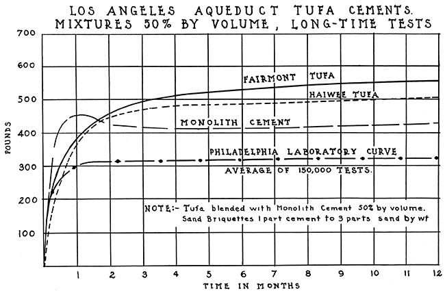
The use made of tufa cement in constructing the Los Angeles aqueduct has been described in "Construction of the Los Angeles Aqueduct, Final Report," by the board of public service commissioners of the city of Los Angeles, 1916. A description of tests made of tufa concrete are included in a paper by the assistant chief engineer, J. P. Lippincott, published in the "Transactions of the American Society of Civil Engineers," vol. 76, p. 520; 1913. Figs. 2 and 3 are copied from this paper. They show the strength of tufa cement at various ages compared with the strength of monolith, a portland cement, over a similar period. Fig. 2 shows that the tufa cements are slower than the standard cement in getting their strength, but they usually attain equal strength in from 6 to 10 days and from then on are stronger (fig. 3). In fact, through the entire period of testing (two years) the tufa cement showed a continued growth in strength. Standard cement, on the other hand, shows a loss in strength between one and four months, and then a slow recovery. It was further observed by the engineers that the tufa concrete had greater flexibility than the straight cement concrete.
Figure 2.
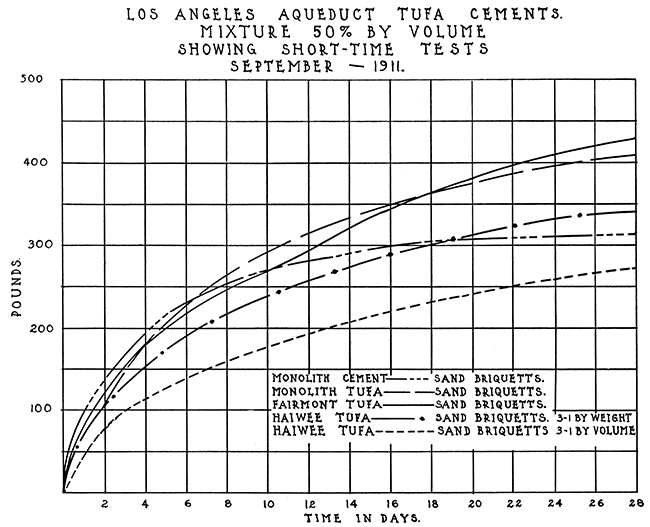
Figure 3.
Another interesting result of the tests made during the construction of the aqueduct is quoted from page 106 of the final report:
"One of the peculiarities of the tufa cement is that larger amounts of tufa than 50 per cent can be added without seriously interfering with its ultimate strength. Careful tests, made both by the laboratories of the city and by government laboratories, show that the tufa combines chemically as well as mechanically with hydraulic cement. A test run of 80 per cent tufa and 20 per cent hydraulic cement gave a strength of 20 pounds in three days, 75 pounds in seven days, 155 pounds in three months; and 300 pounds in six months. For the purpose of testing these leaner mixes in actual construction, a mill run of 100 barrels was made at Haiwee of 75 per cent tufa and 25 per cent hydraulic cement, and put in 100 feet of the lining of the open aqueduct north of the Haiwee reservoir to compare with the 50 per cent blends that were adopted as standard. Little difference could be distinguished. between the two concretes in the work itself. This indicates that a lean cement of this nature, which would be impervious to water, could be successfully used in the lining of open irrigation canals."
The conclusions in regard to tufa concrete are quoted from page 109:
"In conclusion it may be stated that tufa, when finely ground with cement, and used in concrete, combines both chemically and mechanically; blends of 50 per cent, when mixed with sand, give greater tensile strengths, after 10 days, than straight cement mixed with the same proportion of sand; the leaner the mixture, the greater the relative superiority of the tufa cement; in compression, the tufa cement concrete is about 20 per cent less strong in richer mixtures of 1-2-4, and as strong in leaner mixtures of 1-3-6; tufa cements in tension show a continued growth in strength with age up to five years, and in this respect are superior to straight cements, which usually show declining strengths. Tufa concretes must be handled with greater care with reference to both cold and drying, and forms should be left in place about one-third longer. In massive work this feature is negligible. From the fact that the tufa cement is more finely ground, and, in part combines mechanically with other aggregates, carrying the gradation of fineness one step further, it makes a denser and more impervious concrete."
The tufa used in California resembles the German trass, used in the manufacture of trass cements. The report states that the tests, made on the aqueduct are entirely in harmony with those made by the German government on trass cements. However, the tests made by the Los Angeles engineers are open to the objection that they do not cover a long-enough period of time. This objection is in part answered by the service given by the aqueduct in the fifteen years in which it has been in use. Volcanic ash has also been successfully used in the construction of a dam across the Niobrara river at Valentine, Neb.
The California tuff has a silica content of from 68 to 71 per cent. It differs in no essential from the volcanic ash of Kansas except that it is a consolidated rock instead of a powder. This difference is all to the advantage of the Kansas material, for grinding is unnecessary.
The future for the volcanic ash industry in Kansas is promising. There is no reason why extensive use should not be made of ash in cement. Six and one-half million barrels of Portland cement were produced in this state in 1925. Had this cement contained 10 per cent ash there would have been a demand for 122,200 additional tons of volcanic ash during that year. This amount is over three times the 1925 production. Missouri and Iowa together produce twice as much cement as Kansas, and as those states are without commercial ash deposits of their own they would afford additional market for the Kansas material.
The average price charged by the cement producer in Kansas in 1925 was $1.66 per barrel. This is equivalent to $8.83 per short ton. Volcanic ash can be supplied in quantity at a price much lower than that. Consequently its utilization in cement would cheapen the cost of the product without lowering its industrial value.
The present method of marketing ash for use in concrete is to sell it to the contractor, who mixes it with cement on the job. This is an expensive and inefficient procedure. A far better method would be to sell the ash directly to the cement manufacturer, who could mix the materials in his plant and market the product himself. He could not label it Portland cement, because of the restricting definition of that term, but his product would be in no way inferior to Portland cement. Another name could easily be coined.
By no means all of the demand for ash and pumice for abrasive and miscellaneous uses is met by domestic production. One hundred and thirty thousand dollars' worth of pumice was imported from Sicily in 1926. Much of it is ground and is no different from the Kansas ash. But the high freight rates between this state and the Atlantic coast make competition with the Sicilian product difficult on the eastern seaboard. With a sufficiently high tariff it would be possible for domestic ash and pumice (California) to displace foreign pumice except for the finest quality lump used in exacting lithographic work and in finishing copper, silver and other metals before plating. F. J. Katz has calculated that this amount does not exceed 100 tons annually (Mineral Resourees of U. S. for 1918, Pt. II, p, 1184. U. S. Geol. Surv.).
A light-weight structural material of high heat-insulating value has been prepared in France from pulverized pumice with silicates as binders (Jour. Ind. Eng. Chem., vol. 13, 2, p. 171; Feb., 1921. Reported by Ladoo, 1925). This has been used in building furnaces for glass works from which a minimum of heat escapes. Similar use could be made of volcanic ash.
An artificial pumice has been made in Germany from ground sandstone and clay. Due to the low cost of volcanic ash in the United States it is not believed that the domestic manufacture of artificial pumice or its importation from abroad is commercially possible.
Bass, N.W., 1926, Geologic investigations in western Kansas, with special reference to oil and gas possibilities: Kansas Geol. Survey, Bull. no. 11, 96 p.
Barbour, Erwin H., 1916, Nebraska Pumicite: Nebraska Geol. Survey, vol. 4, pt. 27, pp. 357-401.
Buttram, Frank, 1914, Volcanic Dust in Oklahoma: Okla. Geol. Survey Bull. 13, pp. 1-39.
Cragin, F. W., 1896, Pearlette Ash: Colorado College Studies, vol. 6, p. 54
Darton, N. H., 1920, Description of the Syracuse and Lakin quadrangles: U. S. Geol. Survey, Geol. Atlas Series, no. 212 [available online]
Eckel, Edwin C., 1905, Cements, Limes, and Plasters: their materials, manufacture, and properties: John Wiley and Sons, New York, 217 p.
Haworth, E., 1897, Physical properties of the Tertiary: Geol. Survey of Kansas, vol. 2, pp. 251-284
Ladoo, Raymond B., 1925, Pumice and Pumicite, in, Non-Metallic Minerals: McGraw-Hill Book Company, New York City, pp. 455-464
Lee, Willis T., 1912, Extinct Volcanoes of Northeast New Mexico: American Forestry, vol. 18, 357-365.
Merrill, George P., 1885 On Deposits of Volcanic Dust and Sand in Southwestern Nebraska: Nat. Museum Proceedings, vol. 8, page 99
Rubey, W.W., and Bass, N.W., 1925, The geology of Russell County, Kansas, with special reference to oil and gas resources: Kansas Geol. Survey, Bull. 10, pt. 1, pp. 1-86 [available online]
Salisbury, R. D., 1896, Volcanic Ash in Southwest Nebraska: Science, vol. 4, p. 816-817
Todd, J. E., 1897, Science, vol. 5, pp. 61, 62
Udden, J. A., 1893, On a Natural Formation of Pellets: Am. Geol., vol. 11, p. 268-271
Woolsey, L. H., 1905, Volcanic Ash Near Durango, Colorado, in, Contributions to economic geology, 1905: U. S. Geol. Survey, Bull. 285, pp. 476-479
Kansas Geological Survey, Volcanic Ash Resources of Kansas
Placed on web July 7, 2015; originally published in April 15, 1928.
Comments to webadmin@kgs.ku.edu
The URL for this page is http://www.kgs.ku.edu/Publications/Bulletins/14/02_counties.html