Kansas Geological Survey, Bulletin 134, Part 5, originally published in 1959
Next Page--Mulky Coal and References
Originally published in 1959 as Kansas Geological Survey Bulletin 134, Part 5. This is, in general, the original text as published. The information has not been updated.
The Mulky coal is the uppermost coal in the Cherokee Group of rocks (Pennsylvanian). It occurs in Bourbon and Crawford counties, Kansas, where it has been mined, either by stripping or by drifting into the hillsides, only along the edge of the Fort Scott Limestone escarpment. Where mined, the Mulky coal is 7 to 22 inches thick, but averages only 12 inches. Mulky coal is classified as bituminous coal of high volatile A to B rank. Ash content is 10 to 25 percent, volatile matter 30 to 36 percent, moisture less than 2 percent, sulfur 3 to 6 percent, and heating value (moisture free basis) 10,000 to 13,000 Btu. Of the 3,582,630 tons of Mulky coal estimated and computed to have been mined, Bourbon County produced 2,415,360 tons and Crawford County 1,167,270 tons. Measured coal reserves 12 to 22 inches thick are estimated to underlie an area of 21,159 acres, all but 366 acres of which is in Bourbon County, and to total 47,020,450 tons. Indicated reserves underlie 53,679 acres, all in Bourbon County, and total 126,416,550 tons. Recoverable measured Mulky coal is estimated at 35,265,388 tons.
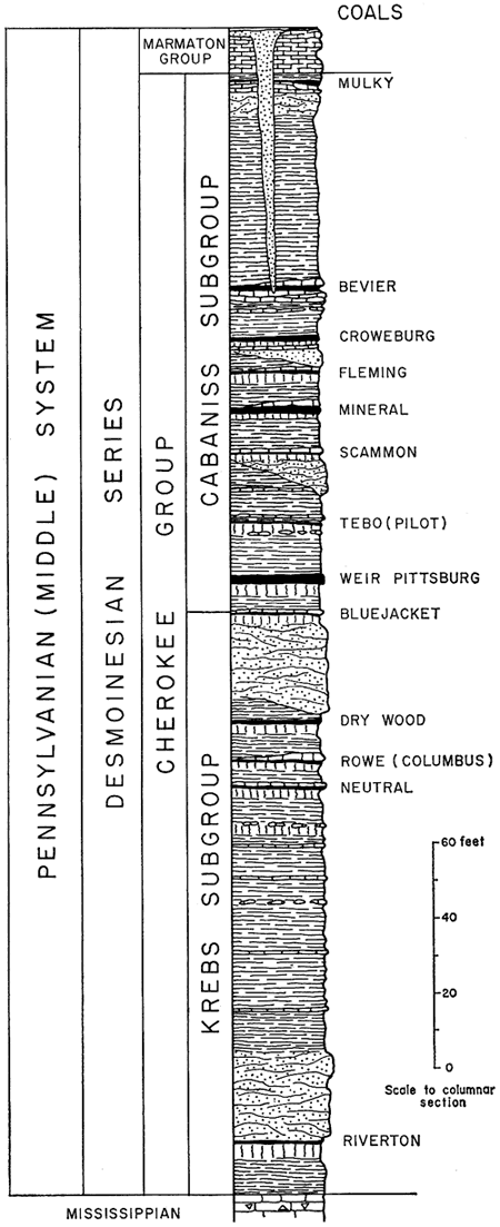
Most of the coal seams of economic importance in Kansas are in the Cherokee Group, which in southeastern Kansas comprises the lower strata of Middle Pennsylvanian age (Fig. 1). Of the 11,618,608 tons of coal mined in Kansas between 1950 and 1957, about 75 percent (8,688,283 tons) was derived from the Cherokee in Bourbon, Crawford, Cherokee, and Labette countiess. In former years Cherokee coals were mined also at Atchison in Atchison County and at Lansing and Leavenworth in Leavenworth County. At least twelve coal seams, most of which at one time or another were mined, are known in the Cherokee Group, eight in the Cabaniss Subgroup (upper part of the Cherokee Group) and four in the underlying Krebs Subgroup (Fig. 2). This report is concerned only with the Mulky coal, which is the uppermost coal in the Cherokee Group.
Figure 1--Map of southeastern Kansas showing outcrop area of Cherokee Group.
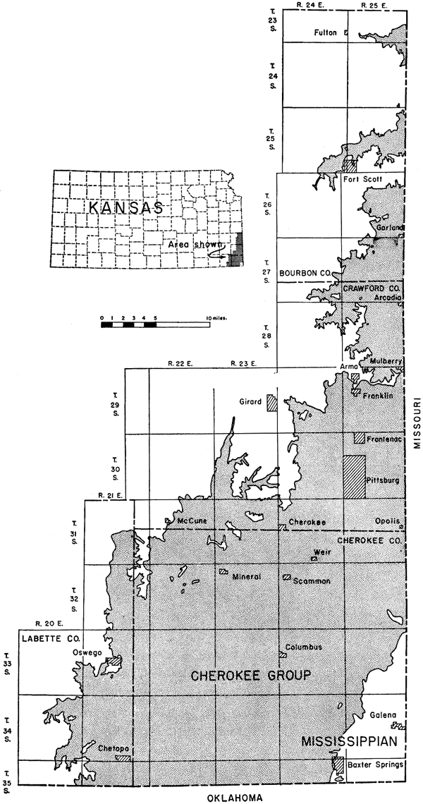
Figure 2--Generalized section of Cherokee Group in Kansas (after Howe, 1956).
Purpose of study--This report is the eighth in a series on Kansas coal started by the State Geological Survey of Kansas in 1942. The report describes the coal resources of the Mulky Formation in the uppermost part of the Cherokee Group of rocks.
The other inventory coal reports thus far published include the coals of the Douglas Group (Bowsher and Jewett, 1943), the Kansas City Group (Schoewe, 1951), the Cretaceous (Dakota) lignites (Schoewe, 1952), the Marmaton Group (Schoewe, 1955), and the coal reserves in Kansas (Abernathy, Jewett, and Schoewe, 1947). In addition, Abernathy (1944) reported on mined areas of the Weir-Pittsburg coal and on the strip-mined areas in the Southeastern Kansas coal field (Abernathy, 1946). Other publications dealing with coal include a "Special Report on Coal" by Haworth and Crane (1898) and a report by Young and Allen (1925), also reports on the post-Cherokee coals (Whitla, 1940), the coals of the southeastern Kansas coal fields (Pierce and Courtier, 1937a), coal research in Kansas (Schoewe, 1951a), the petrography of southeastern Kansas coals (Hambleton, 1953), and the petrology of the Nodaway underclay (McMillan, 1956).
Previous work--The Mulky coal was one of the first if not the first coal mined in southeastern Kansas. According to Brown (1896, p. 15), the coal was mined for use at the United States military post established at Fort Scott in 1842. During the Civil War period, government transport wagons loaded at Fort Leavenworth in Leavenworth County with commissary supplies for the Fort Scott post returned to Leavenworth loaded with Mulky coal. In 1854 and before, the Fort Scott Town Company in promoting their townsite advertised to advantage the presence of coal and proclaimed, "the country around Fort Scott abounds in coal of the very best quality. It crops out from nearly every hill and underlies the townsite. It is in general use in town for fuel" (Malin, 1950, p. 87). From that time to the present, the Mulky coal has been mined continuously. Mudge, first State Geologist of Kansas, as early as 1864 observed coal cropping out in the banks of Marais des Cygnes and Little Osage Rivers in Bourbon County and in various places farther southwest into Indian Territory (Mudge, 1866, p. 9, 20). He thought that the coal he observed was the coal currently classified as the Mulberry seam in the Marmaton Group (Schoewe, 1955), but it is to be noted that although some of it was Mulberry coal, some of it undoubtedly was the Mulky and lower coals in the Cherokee. Swallow (1866, p. 25, 56), second State Geologist of Kansas, and Hawn (1866, p. 110) noted coal in Bourbon County and correlated it with the Mulberry coal of Linn County. Present knowledge of the distribution of the Mulky coal in northern Bourbon County suggests that Swallow's and Hawn's correlations of this coal with the Mulberry coal in parts of Linn County and northern Bourbon County are in error.
As geologist for the Kansas State Board of Agriculture, Mudge wrote (1878, p. 86) that three principal coal seams were being worked in Kansas--the Osage, Cherokee, and Fort Scott seams. Regarding the Fort Scott (Mulky) coal, he stated that it appears at and near the surface in various places in Bourbon and Linn counties, but is irregular, appearing and disappearing erratically. The coal was said to be less than 2 feet thick except in a few places. It coked well, and good gas coal was obtainable from it, producing 8,000 to 9,000 cubic feet of gas per ton. Coal was shipped from various stations along the line of the Missouri River, Fort Scott & Gulf Railroad between 1872 and 1877. It is reasonably certain that the 3,620 tons of coal shipped from Fort Scott was Mulky coal, but it is uncertain whether all coal shipped from the stations south of Fort Scott was Mulky coal. Probably some of it came from seams lower in the Cherokee. Miscorrelations of the Mulky coal with other coals persisted as late as 1940. In 1929, Moore (p. 4) incorrectly named the Mulky coal the Lexington coal, which he stated was mined locally in the vicinity of Fort Scott. The Lexington coal is in the Labette Shale, which overlies the Fort Scott Limestone, whereas the Mulky coal is below the base of the Excello Formation, in the upper part of the Cherokee Group, next below the Fort Scott. Moore's description of the rocks associated with the coal is correct, however, as is his classification of the Fort Scott Limestone.
Similarly, Whitla (1940, p. 29) correlated some of the Mulky coal mined northeast of Hammond in northern Bourbon County with the Summit coal of the Marmaton Group. The Summit coal is in the Little Osage Shale member between the two limestone members of the Fort Scott Limestone. Stratigraphically the Summit coal is no more than 12 feet above the Mulky or Fort Scott coal. From Whitla's description of the coal-containing rock and Schoewe's (1955, p. 57) field investigation of coals in northern Bourbon County, it is clear that Whitla's mined "Summit coal" is definitely Mulky coal. Although the Summit coal is reported to have been mined, the writer has nowhere seen any thick enough to mine nor any places where it was mined. Saunders (1873, p. 388; 1896, p. 31) reported a fine vein of coal about 30 inches thick that cropped out in northern Bourbon County and farther northeast and southwest. This vein, called the Osage vein and also the Fort Scott coal, appeared in commerce under two names--black and red. The red is now recognized as the Fort Scott or Mulky coal, whereas the black, which yielded considerable gas, is probably the Mulberry coal. Hay (1887, unnumbered figure facing p. 205; 1887a, p. 60) recognized the Fort Scott coal, although not by name, in a report on natural gas in eastern Kansas. He included a cross-section of strata exposed between Fort Scott, Kansas, and Nevada, Missouri. This section shows the Fort Scott Limestone [Higginsville Limestone member], an unnamed shale [Little Osage Shale member], the Fort Scott "Cement" [Limestone] [Blackjack Creek Limestone member], and a shale [Excello Shale] containing an unnamed coal seam [Mulky coal].
Several years later, in a report on the stratigraphy and coal deposits of the Fort Scott area, Hay (1893, p. 113, 132) called attention to the Fort Scott (Mulky) coal, which was also called Mound coal because of its outcroppings near the top of the promontories and mounds that overlook the lower levels of the land toward Dry Wood Creek and as far south as northeastern Crawford County near Fort Scott. In addition, Hay (1893, p. 132) presented the following stratigraphic section, which he stated is a typical section in the city of Fort Scott (Table 1).
Table 1--Section measured by Robert Hay at Fort Scott, Bourbon County, Kansas, in 1891.
| 1. Fragment of the hard, rough layer, limestone, 2 to 10 feet (this is the Pawnee limestone, which further west runs up to 60 feet thick) | [Higginsville Limestone member, Fort Scott Limestone] |
| 2. Black laminated slate (almost coal), 5 feet | [Little Osage Shale member, Fort Scott Limestone] |
| 3. Yellowish and greenish clay shale, 4 feet | |
| 4. The hydraulic limestone (cement rock), 4 feet | [Blackjack Creek Limestone member, Fort Scott Limestone] |
| 5. Clay with nodules, 6 inches to 1 foot | [Excello Shale] |
| 6. Laminated coal shale, 2 feet | |
| 7. Coal, 18 inches to 2 feet | [Mulky] |
| 8. Laminated yellow shale, 20 feet | |
| (Names in brackets are those in current use by the State Geological Survey of Kansas.) | |
Except that the uppermost limestone is called the Pawnee limestone, a unit that crops out farther west and which is at least 50 feet stratigraphically above the uppermost limestone unit (Higginsville Limestone member of Fort Scott Limestone), the section is correct. In commenting on some of the beds Hay writes that, "The 'cement' rock, No. 4, is very persistent, and is characteristic of the district topography. It thickens in places to six or seven feet. No. 7 is the Fort Scott coal. It is probably the coal worked just east of Girard in Crawford County; . . ." Except for noting the presence of the Fort Scott or Mulky coal and giving general information as to its thickness, production, and the mining methods employed, the early reports, published mainly by the Kansas State Board of Agriculture, include little of scientific value relative to the Mulky coal. In 1895, detailed stratigraphic studies of Kansas rocks were begun by the University Geological Survey.
The first preliminary report on the coals of the Cherokee Group was included in Haworth's report on the coal fields of Kansas. In referring to the Mulky coal, Haworth (1895a, p. 301) wrote, "Farther north in the vicinity of Fort Scott coal is found within 8 or 10 feet of the Cherokee shales. The veins average about 13 inches in thickness, but in places it is a little more. It is so close to the 'cement' rock that usually the latter has to be removed to obtain the coal." The coal was exposed in the banks of the numerous creeks and in the many ravines for miles around Fort Scott. According to Haworth, the coal had been mined in "hundreds of places by the 'stripping' process, the coal having been followed back into the bank 10, 20, 30 or more feet." The coal was known in the markets as the Fort Scott "red" coal. In his report Haworth discusses the physical and chemical properties of Kansas coals and summarizes Blake's (1889, p. 45) and Bailey's (1889, p. 48) chemical analyses of Kansas coals. In a table taken from A. C. Gallagher (1894, p. 179), showing the number of pounds of coal equal to one cord of standard oak wood, Haworth lists 2,670 pounds for the Fort Scott coal. Much of the same information is repeated (Haworth, 1898) in his first report on the mineral resources of Kansas and in his more elaborate report (Haworth and Crane, 1898) published in the same year by the University Geological Survey.
The report by Young and Allen (1925) brings much of the information presented by Haworth and Crane up to date as of that year. The most detailed report on the coals of southeastern Kansas (Pierce and Courtier, 1937a) does not include Bourbon County, but the strata associated with the Mulky coal are described for Crawford, Cherokee, and Labette counties. The Fort Scott coal is discussed (p. 78), and two tables on chemical analyses of the coal are included. The report contains an excellent geologic map of the southeastern Kansas coal field (Plate 1) showing in addition the location of the various coal strip pits and the traces of some of the Cherokee coals. Previous to the publication of their coal report, Pierce and Courtier (1937, p. 17) briefly discussed the general stratigraphy of the Cherokee.
A paper by Jewett and Schoewe (1942, p. 77) refers to the coal fields of Kansas, briefly discussing the history of the coal fields of the southeastern part of the state, the products, and coal reserves. The "Summit coal" in northeastern Bourbon County, referred to on page 84 of that report, is now identified as Mulky coal. Abernathy's map (1946) showed coal strip mines in southeastern Kansas as of January 1, 1946, including the name and location of every Mulky coal strip mine known at that time. The accompanying report briefly describes the strata associated with the Mulky coal and includes data pertaining to the coal itself. In a later report (Abernathy, Jewett, and Schoewe, 1947), the proved (measured and indicated) and potential or inferred reserves of Mulky coal are estimated. The most recent comprehensive paper describing the Mulky coal and associated strata (Howe, 1956) is concerned primarily with description of strata of the Cherokee Group and contains numerous stratigraphic sections describing and showing graphically the Mulky coal. This is also the first report to use the new classification of Desmoinesian (Pennsylvanian) rocks, although a preliminary announcement appeared 3 years earlier (Searight and others, 1953).
The first published analyses of Kansas coal (Saunders, 1873) include analyses of the Mulky coal showing volatile matter 33.35 percent, fixed carbon 54.10 percent, and ash 12.05 percent. Blake (1889, p. 45) discussed the evaporative power of Kansas coals; Bailey (1889, p. 47) also reported the composition of Kansas coals, but Bailey's analyses differ somewhat from Saunders' in that Bailey's show the volatile matter greater by 8.41 percent, the fixed carbon less by 6.55 percent, and the ash content less by 4.3 percent. Both sets of analyses were quoted by writers of later reports dealing with Kansas coal.
In addition to papers describing the stratigraphy of rock associated with the Mulky coal by Swallow (1866), Hay (1887), Haworth and Kirk (1894), Bennett (1896), Adams (1896), and Haworth (1898) should be mentioned the work of Adams, Girty, and White (1903), who give an outline of the detailed stratigraphy of Kansas rocks, including preliminary faunal lists. Also, Jewett (1941, 1945) discusses the stratigraphy and classification of the Marmaton Group, and Howe (1956) presents the most recent and thorough description of the Cherokee Group and includes numerous stratigraphic sections. In addition, Abernathy (1936) reviewed the Cherokee shale of southeastern Kansas and proposed a classification of lithologic units based on the cyclical sedimentation. He later published a summary of this work (Abernathy, 1937, 1938). Abernathy is the first to attempt to classify the Cherokee as a group divisible into fifteen formations or cyclothems. Other reports of a general nature are those of Moore (1936, 1940), Landes (1937), and Moore and others (1944, 1951).
Field and laboratory investigations--Field work that forms the basis of this report was started in July 1955 and was completed in 1958. Effort was made to trace and locate all Mulky coal throughout Bourbon and Crawford counties. The stratigraphic position, occurrence, physical nature, and thickness of the coal and adjacent rocks, and the nature and thickness of overburden were studied in the field. All active and abandoned mines were located on maps. Data concerning production, mines, mining methods, and history of mining were obtained for old settlers and miners living in the mining district and from publications. Air photographs were used in obtaining the location, size or area, and pattern of the larger strip-pit mines. Coal samples were collected and were analyzed in the geochemistry laboratories of the State Geological Survey under the supervision of Russell Runnels.
Acknowledgments--Mr. Allen Diller assisted in the field during the field seasons of 1955 and 1956, Mr. Thomas Thompson in 1957, and Mr. Leonard Howard in 1958. Their many varied services are appreciated. Much help relative to the location and history of the old abandoned mines was obtained from local residents of Bourbon and Crawford counties. Thanks are also due to the Fort Scott Chamber of Commerce and members of the Fort Scott Kiwanis Club for providing city maps of Fort Scott and supplying names of persons well acquainted with the mining of the Mulky coal in the early days at Fort Scott and vicinity.
The Cherokee Groups of rocks crops out in an area of about 1,000 square miles in southeastern Kansas, including parts of Labette, Cherokee, Crawford, and Bourbon counties (Fig. 1). Physiographically, the area of outcrop of Cherokee rocks constitutes the Cherokee Lowland (Schoewe, 1949, p. 276) developed upon the weak shales and sandstones of the Cherokee Group, which at the outcrop in Kansas ranges in thickness from 200 to 500 feet, averaging about 450 feet. Topographically the area is a low-lying, erosional plain whose surface slopes to the west at an average grade of about 10 feet per mile (Abernathy, 1946, p. 129); the total relief is about 250 feet. The surface is gently undulating except for a few sand stone-capped erosional remnants, of which the broad, flat-topped, mesa-like Timbered Hills constitute the largest. The Timbered Hills rise 80 feet above the level of th surrounding country about 7 to 8 miles north of Baxter Springs in Cherokee County. The valleys are wide, shallow, and flat. Neosho, Spring, and Marmaton Rivers and Dry Wood Creek and their tributaries drain the Cherokee Lowland. Pittsburg and Columbus are within the lowland, whereas Fort Scott, Oswego, and Baxter Springs are at its border.
Smaller towns located in the unit include Cherokee, Weir City, Mineral, Sherman, Hallowell, Chetopa, Girard, Frontenac, Arma, Mulberry, and Arcadia. The Cherokee Lowland is traversed north-south by U. S. Highways 59 and 69 and east-west by U.S. Highways 54 and 160. State Highways 31, 39, 57, 96, 102, 103, 104, and 126 cross the area in east-west direction, whereas State Highways 7 and 26 traverse the lowland north-south. The Cherokee Lowland is also served by six railroads: Missouri Pacific; Missouri-Kansas-Texas; St. Louis-San Francisco; Kansas City Southern; Kansas, Oklahoma and Gulf; and Atchison, Topeka, and Santa Fe.
The Cherokee Group, averaging approximately 450 feet thick, is middle Pennsylvanian in age and comprises the oldest Pennsylvanian rocks in southeastern Kansas. It overlies the lead- and zinc-bearing limestone, of Mississippian age, and is overlain by the Marmaton Group of rocks, which contains the Mulberry coal (Schoewe, 1955). In 1953 at a conference held at Nevada, Missouri, representatives from the State Geological Surveys of Kansas, Missouri, Oklahoma, Nebraska, and Iowa agreed on a division of the Cherokee shales into two groups, Krebs and Cabaniss, and eighteen formations (Searight and others, 1953). Subsequently, October 17, 1955 (Howe, 1956, p. 8, 21) the State Geological Survey of Kansas re-adopted the discarded group term Cherokee and relegated the Krebs and Cabaniss Groups to the rank of subgroups. The Cherokee Group is now subdivided by the State Geological Survey of Kansas into eighteen formations, twelve of which are in the upper (Cabaniss)) subgroup and six in the lower (Krebs) subgroup (Table 2). [Note: The State Geological Survey of Kansas is still studying the classification as there is some uncertainty as to where to draw the line between the Krebs and Cabaniss. The previously accepted classification is therefore followed in discussing the stratigraphy involving the Mulky coal.]
Table 2--Classification of the Cherokee Group in Kansas as of October 17, 1958. Some further modification of the classification of the Cherokee Group is being considered by the State Geological Survey of Kansas. The rank of Cabaniss and Krebs may be changed to formations and that of the listed formations to members. Whether the top of the Seville Limestone will be retained as the boundary between the Krebs and Cabaniss has currently not been decided.
| System | Series | Group | Subgroup | Formation |
|---|---|---|---|---|
| Pennsylvanian (Middle) |
Desmoinesian | Cherokee | Cabaniss | Excello Mulky Lagonda Bevier Verdigris Croweburg Fleming Robinson Branch Mineral Scammon Tebo Weir |
| Krebs | Seville Bluejacket Dry Wood Rowe Warner Riverton |
Each formation, except in a few special cases, is composed of lithologic units extending from the top of a specified coal bed to the top of the next higher coal bed. Lithologic units constituting the formation consist of dark shale, dark irregular limestone, gray shale, limestone, sandstone, underclay, and coal. The Cherokee Group is economically important for its coal. At least fourteen coals are known in the group, twelve of which have been or are now being mined (Fig. 2). The Mulky coal of this report is the uppermost coal in the Cherokee Group and occurs stratigraphically in the Mulky Formation near the top of the Cabaniss Subgroup. For the purpose of this report only the Excello and Mulky Formations of the Cherokee Group and the Fort Scott Limestone formation and the Englevale Sandstone member of the Labette Shale of the overlying Marmaton Group require discussion.
The key to mapping and locating the Mulky coal is the Fort Scott Limestone formation, Marmaton Group, and more especially its lower unit, the Blackjack Creek Limestone member.
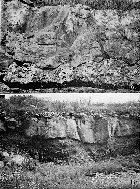
Blackjack Creek Limestone member--The Blackjack Creek Limestone member is a massive limestone generally 3.5 to 17.5 feet thick, although at the outcrop at the spillway of Rock Creek Lake, in the NW sec. 2, T. 26 S., R. 24 E., Bourbon County, the limestone pinches from a thickness of 42 inches to almost nothing in a horizontal distance of no more than 100 feet (Pl. 2A). At several places the Blackjack Creek is missing, as at the strip pit in the NE corner sec. 27, T. 26 S., R. 25 E., where a channel sandstone rests directly on the Excello Shale (Pl. 4A). The Blackjack Creek consists of a single bed or two or three beds. When fresh the rock is ash white to gray but on weathering assumes a yellowish-brown to rusty appearance. It is granular to crystalline, pseudo-brecciated, and dense to lithographic. In the area where the Mulky coal has been mined, the Blackjack Creek is known to dip in various directions at angles measurable in degrees rather than feet per mile, and it is also faulted at places, as in the abandoned strip pit in the SEI/4 sec. 12, T. 27 S., R. 24 E., Bourbon County (Pl. 2B). Fossils, chiefly large crinoid stems, brachiopods, bryozoans, trilobite pygidia, fusulinids, cup or horn corals, and colonial corals, are common in the rock. The colonial coral Chaetetes is common as single isolated masses, some of which are several feet in diameter, and as reef-like structures of which the largest one seen measures 130 feet horizontally and 18 inches vertically (Pl. 3A). The contact of the Blackjack Creek Limestone with the underlying Excello Shale is at places very irregular (Pl. 3B).
Plate 2--A, Pinching out of Blackjack Creek Limestone at spillway of Rock Creek Lake, NE NW sec. 2, T. 26 S., R. 24 E., Bourbon County, Kansas. Blackjack Creek Limestone, first limestone below spillway top, is 42 inches thick at right of exposure and almost nothing at left side shown in this view. B, Normal fault, throw 4.5 feet, in Blackjack Creek Limestone; upthrow side to left; north highwall, strip pit, SW sec. 12, T. 27 S., R. 2,4 E., Bourbon County, Kansas.
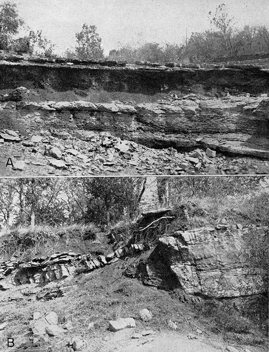
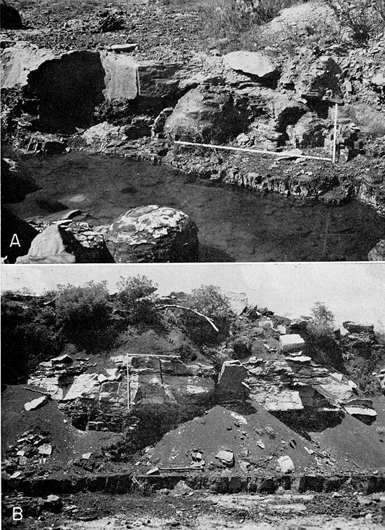
Plate 3--A, Blackjack Creek Limestone, showing massive bedding and part of a Chaetetes coral reef 130 feet long. Thickest part of reef shown is 18 inches. Highwall, strip pit, NE cor NW sec. 8, T. 27 S., R. 25 E., Bourbon County. B, Irregular contact of Blackjack Creek Limestone on Excello Shale, uppermost member of Cherokee Group. Highwall, strip pit, SW sec. 8, T. 35 N., R. 33 W., Missouri, about 0.8 mile east of Kansas-Missouri line and 0.8 mile south of U. S. Highway 54.
The Blackjack Creek Limestone is known locally as the "cement rock" and has been quarried since 1868 for the manufacture of natural cement. The Fort Scott Hydraulic Cement Company, operated by Mr. E. O. Thomas and his two sons, Earl and F. H., is the oldest cement plant in continuous operation in the state, having had its start in 1887, and it is the only plant in Kansas making natural cement. The suitability of the Blackjack Creek for the making of natural cement was recognized in 1867, when Mr. A. H. Bourne sent a sample of the rock to Professor Louis Agassiz of Harvard University for analysis. Agassiz's comment was, "a very superior quality of hydraulic cement" (Haworth, 1898, p. 66).
Little Osage Shale member--Of lesser importance than the Blackjack Creek Limestone member in tracing the Mulky coal are the Little Osage Shale and Higginsville Limestone members overlying the Blackjack Creek Limestone. The Little Osage Shale is 4 to 12 feet thick and contains in its lower part the Summit coal, which is 3 to 6 inches thick. This coal has been confused with the Mulky coal, from which it is separated by no more than 12 feet. Although the Summit coal is reported to have been mined, no evidence was seen in the field in Kansas, and at no observed outcrop was the coal thick enough to be mined. The shale overlying the coal is dark gray to black and fissile to blocky, and contains numerous small subspherical phosphatic nodules. A dense limestone, the Houx, less than 12 inches thick, occurs above the black shale and a few inches to 2 feet below the Higginsville Limestone member. Beneath the Summit coal is a light-gray to dark-gray shale.
Higginsville Limestone member--Above the Little Osage Shale is the Higginsville Limestone, the upper member of the Fort Scott Limestone formation. The rock is mostly thin bedded and is light gray and fossiliferous. Large coral colonies of Chaetetes as well as large crinoids stems and numerous small to medium fusulinids are the common fossils found in the limestone. The average thickness of this member is 15 feet. The Higginsville Limestone is important only in tracing the escarpment of the Fort Scott Limestone and thus indicating the nearby presence of the Blackjack Creek Limestone.
Plate 4--A, Englevale Sandstone, Labette Shale formation, replacing Blackjack Creek Limestone. Englevale Sandstone, a river channel deposit, rests on about 1 foot of Excello Shale. Note large spherical concretion in Excello Shale at left end of folding rule, which is resting on Mulky coal. Large Excello concretion in foreground. North end of strip pit, NE cor. sec. 27, T. 26 S., R. 25 E., Bourbon County, Kansas. Compare with B. B, Normal sequence of strata, Blackjack Creek Limestone, Excello Shale, and Mulky coal. Garrett Brothers strip pit, SE sec. 4, T. 27 S., R. 25 E., Bourbon County, Kansas.
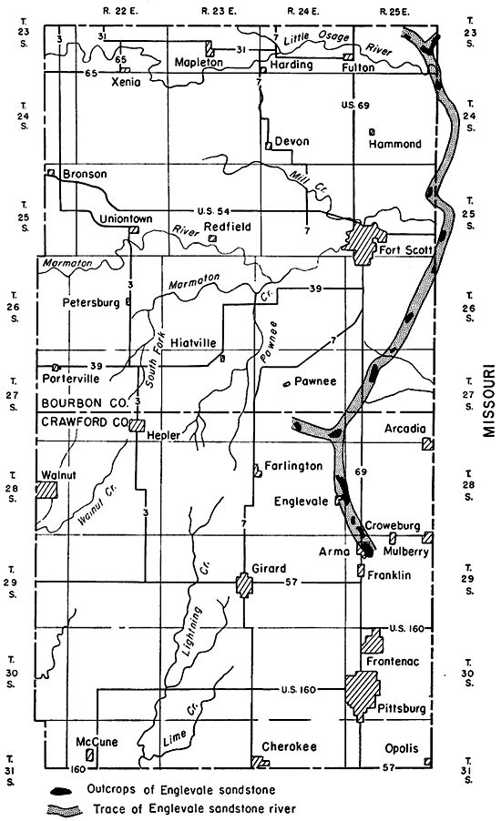
Although not included in the Cherokee Group, the Englevale Sandstone needs description because of its relation to the Mulky coal and to the computation of Mulky coal reserves. Pierce and Courtier (1935, p. 1061; 1937a, p. 45), while mapping the geology and coal resources of the southeastern Kansas coal field in Crawford, Cherokee, and Labette counties, discovered and mapped a sandstone for which they proposed the name of Englevale channel sandstone. [Note: The Englevale channel is being subjected to a special study for a master's thesis, Department of Geology, Kansas University, by Leonard Howard, research assistant to Schoewe for the 1958 field season.] The sandstone crops out in discontinuous patches from Arma northwestward for a distance of about 9 miles towards Cato in northeastern Crawford County. The average width of the sandstone belt as mapped by Pierce and Courtier is 0.4 mile. Because the channel in which the sandstone was deposited trenches the Fort Scott Limestone at places, the Englevale is obviously younger than the Fort Scott Limestone, and they thought it probably equivalent to lower Labette Shale (Marmaton). In 1955, while mapping coal in the uppermost part of the Cherokee Group (Mulky or Fort Scott coal) in Bourbon and Crawford counties, Schoewe discovered and mapped a similar channel sandstone extending from the northeast corner of Bourbon County southwestward for a distance of approximately 25 miles to the northernmost Englevale deposit mapped by Pierce and Courtier in Crawford County near the Bourbon-Crawford County line (Fig. 3). The Bourbon County channel sandstone is definitely to be correlated with the Crawford County sandstone deposit.
Figure 3--Map of Bourbon and Crawford counties, Kansas, showing course of Englevale river channel.
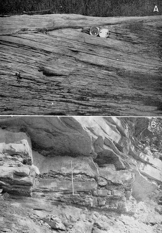
The Englevale Sandstone is soft, friable, light- to dark-brown to reddish-brown speckled rock, which weathers to a distinctly reddish to brownish soil. The sandstone is very micaceous and ranges from fine to coarse. Almost everywhere the rock is distinctly cross-bedded (Pl. 5A). The prevailing direction of the cross-bedding is south except at the outcrops 2 miles west of Cato in Crawford County, where the dip is northwestward. A notable characteristic of the Englevale is the association of numerous pieces of petrified wood, a feature which aids greatly in distinguishing this unit from the "Squirrel" sandstone stratigraphically close below in the upper part of the Lagonda Shale. Much of the petrified wood consists of tan to light-brown, hard, slender, elongate, heavy fragments 1/8 to 5 inches thick and as much as 12 inches long. It contains considerable secondary growth of small but megascopic well-developed quartz crystals lining what apparently were linear cracks where the wood had split. In addition to the petrified wood, impressions of such plants as calamites, lepidodendrons, and ferns were observed at several outcrops. The Englevale Sandstone is distinctly stratified, individual beds ranging from 1 to 18 inches in thickness. At places, as in the NE sec. 36 and the SE corner sec. 25, T. 27 S., R. 24 E., somewhat more than 4 miles north of Englevale, the sandstone forms massive overhanging cliffs (Pl. 5B). The uppermost sandstone at this exposure is at least 9 feet thick and has the general appearance of a single unit, but weathered surfaces reveal that the unit is composed entirely of layers about 1/2 inch thick, some of which are more resistant than others, giving the unit a ribbed effect.
Plate 5--A, Englevale Sandstone showing prevailing southerly dip of cross-bedding, SE sec. 1, T. 26 S., R. 25 E., Bourbon County, Kansas. B, Outcrop of Englevale channel sandstone; conglomeratic zone 4 feet thick forms base resting on Lagonda Shale. Detail of conglomerate shown in Plate 6A. West-facing bluff on West Fork of Dry Wood Creek, SE sec. 25, T. 27 S., R. 25 E., Crawford County, Kansas.
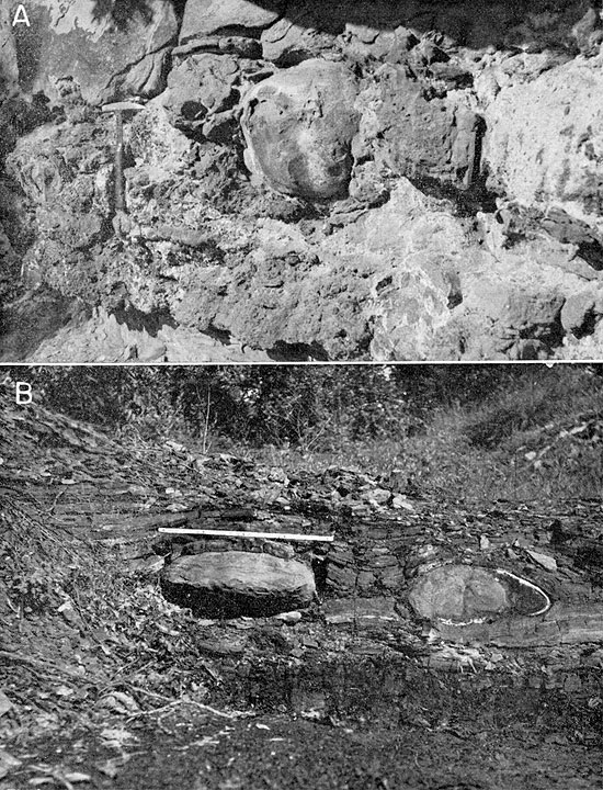
Conglomerate containing fragments of older strata, and seemingly not observed by Pierce and Courtier (1937, p. 46), forms the basal part of the Englevale at several places in Crawford and Bourbon counties, notable in the NE sec. 36, T. 27 S., R. 24 E., Crawford County, which in reality would serve better as type section for the Englevale Sandstone than the outcrop in the vicinity of Englevale. The conglomeratic zone at the first locality constitutes the lowermost 4 feet of the Englevale. It consists of three conglomerate beds and two interfingering sandstone layers all of which vary in thickness in short distances. As the conglomerate thickens, the discontinuous interfingering sandstone layers thin, and all three conglomeratic layers merge into one as much as 22 inches thick (Pl. 6A), only to split again into conglomerate and sandstone layers. Most of the conglomeratic material is coarse and is a poorly sorted mixture of pebbles of Fort Scott Limestone, especially fragments of Chaetetes coral as much as 18 inches in diameter, concretions from the Excello Shale 12 to 18 inches in diameter, black fissile shale as much as 3 inches thick and 2 to 3 feet long, coal streaks as much as 1 inch thick and a few inches to several feet long, crinoid stems as much as 1 inch in diameter, phosphatic nodules, limonitic nodules, and petrified wood. Chaetetes fragments occur in the interfingering sandstone. The contact of the conglomeratic zone with the underlying well-bedded sandy shale of the Lagonda is irregular.
Plate 6--A, Detail of conglomerate in basal part of Englevale channel sandstone. Note large Excello Shale concretions to right of hammer. Locality same as Plate 5B. B, Typical limestone concretions in Excello Shale; folding rule exposed, 2 feet. Concretions contain pyrite, which oxidizes white as seen on concretion to right. Mulky coal, 7 inches thick, about 6 inches beneath concretions. Pit in NE cor. sec. 34, T. 27 S., R. 24 E., Crawford County, Kansas.
The thickness of the Englevale varies from place to place; maximum thickness observed is 60 feet. The Englevale channel is known to trench all of the following formations: Fort Scott, Excello, Mulky, Lagonda, and Bevier. No Englevale Sandstone was seen below the uppermost bed of the Verdigris Limestone. Especially good exposures where the profile of the Englevale trench cutting the Fort Scott Limestone may be observed or traced are:
NE sec. 23, T. 26 S., R. 25 E., west highwall, pit
NE cor. sec. 27, T. 26 S., R. 25 E., pit
SE sec. 33, T. 26 S., R. 25 E., north highwall, pit
SW sec. 9, T. 27 S., R. 25 E., west highwall, pit
SE sec. 25, T. 27 S., R. 24 E., east bluff, West Fork of Dry Wood Creek
All but the last are in Bourbon County.
The direction of flow of the stream that deposited the Englevale Sandstone is interpreted to have been in general southward. This belief is supported by the fact that all cross-bedding except that 2 miles west of Cato in Crawford County dips in general southward, by the orientation of the petrified wood fragments found in the sandstone, by the decrease in sand grain size from north to south, and by the pattern of the river system. It is believed that for at least part of the time in its history, the river west of Cato in Crawford County flowed northwestward, as indicated by the cross-bedding of the sandstone in that direction. Whether the stream initially flowed southward in Crawford County towards Arma and later was captured by headward erosion of a pirate stream farther west or whether the original stream flowed southward in Bourbon County and then west in Crawford County and its westward extension was later tapped by a stream working by headward erosion from the south or general vicinity of Arma is not yet established. It seems reasonably certain, however, that stream piracy was involved in the history of the Englevale stream in Crawford County. A map showing the general course of the stream that deposited the Englevale Sandstone in Bourbon and Crawford counties, Kansas, is presented in Figure 3.
From field observations, the Englevale Sandstone in Bourbon and Crawford counties, Kansas, is definitely known to be younger than Fort Scott Limestone and older than middle Labette Shale.
The Excello Formation is the uppermost formation of the Cherokee Group and of the Cabaniss Subgroup as now classified. The Excello underlies directly the Blackjack Creek Limestone member of the Marmaton Group or in places the Englevale Sandstone member of the Labette Shale, a channel sandstone of still younger age. The formation is black fissile to blocky shale characterized by abundant small subspherical phosphatic concretions, some of which have coprolitic nuclei (Howe, 1956, p. 89). Near the base of the formation, large subspherical limestone concretions, some as much as 2 feet in diameter (Pl. 6B), are common. They are composed of hard, dense, blackish limestone, have pyritic rinds, and contain an ammonite tentatively assigned to Eoasianites cf. E. globulosus (Meek and Worthen). According to Howe (1956, p. 88), fossils in the Excello Shale include conodonts and Orbiculoidea missouriensis. Silicified tree stumps have been found in the base of the Excello Shale (Pierce and Courtier, 1937a, p. 78) at several places. In an abandoned strip pit in the NE sec. 10, T. 29 S., R. 25 E., south of Mulberry in Crawford County several such tree stumps, 30 inches in height and 20 to 24 inches in diameter, were lying scattered about on the floor of the pit. The thickness of the Excello Shale ranges from 10 to 68 inches. The minimum thickness of 10 inches was measured in the NE sec. 23, T. 26 S., R. 25 E., at a place where the Blackjack Creek and overlying rocks have been removed by erosion and have been replaced by a channel sandstone.
The Mulky Formation, which underlies the Excello, consists in descending order of the Mulky coal seam, an underclay, the Breezy Hill Limestone and, in northern Oklahoma, the Kinnison Shale. Exposures or outcrops of the Mulky Formation in the Mulky coal mining area of Bourbon County and northern Crawford County are limited to the Mulky coal seam. The underclay and the Breezy Hill Limestone member are not seen in the strip pit mines but only in a few places where the topography is relatively rough, as in the Breezy Hill area 2 to 3 miles east of Arma in Crawford County. Consequently, for mapping the Mulky coal the seldom seen underclay and Breezy Hill Limestone are not important. According to Howe (1956, p. 87), the gray underclay is commonly silty, particularly in its upper part, and plastic to limonitic in its lower part. Fossil root impressions and other plant material are common in this unit, which ranges in thickness from a feather edge to 11 feet. The maximum thickness observed by Howe was in the SW SW sec. 16, T. 31 S., R. 23 E., Cherokee County. At most places, however, the underclay is not more than 4 feet thick and at many places is less than 2 feet thick.
Breezy Hill Limestone member--The Breezy Hill Limestone underlies the Mulky coal underclay. Although seldom seen in the area where the Mulky coal has been mined, the limestone needs to be noted because of its nearness to the Mulky coal. The limestone is whitish to light gray, silty, and crumbly. Its thickness averages 20 inches, but is known to range from a feather edge to 8 feet. The rock is irregularly bedded and nodular, being made up of angular to rounded fragments of dense gray limestone in a matrix of light-gray, friable, sandy, impure limestone; it weathers to a coarse rubble (Howe, 1956, p. 85). Locally in Cherokee and Labette counties the Breezy Hill Limestone is composed almost entirely of fusulinid tests imbedded in a matrix of calcareous sand and silt (Howe, 1956, p. 85). This phase was not observed in the area where the Mulky coal has been mined.
According to Pierce and Courtier (1937a, p. 33), on the west side of Breezy Hill about 2 miles southwest of Mulberry in Crawford County the Breezy Hill Limestone consists of 1 to 2 feet of impure limestone, whereas in the eastern part of the same hill the limestone attains a maximum thickness of 8 feet and is similar in appearance to the Blackjack Creek Limestone of the Fort Scott Limestone formation.
Next Page--Mulky Coal and References
Kansas Geological Survey, Geology
Placed on web April 21, 2009; originally published in June 1959.
Comments to webadmin@kgs.ku.edu
The URL for this page is http://www.kgs.ku.edu/Publications/Bulletins/134_5/index.html