![]()
Prev Page--Table of Contents || Next Page--Stratigraphy
Introduction
Purpose
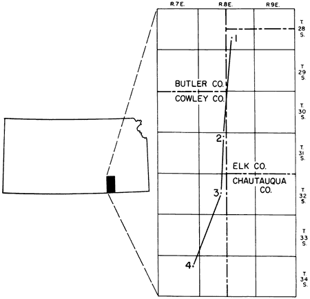
This investigation is an attempt to reconstruct the environment of deposition of the Grenola Limestone. A detailed study of the beds is necessary to accomplish this end; consequently, the study was restricted to the type area of the Grenola formation in Elk and Cowley Counties, Kansas (Fig. 1). The analysis required is essentially threefold, involving techniques of stratigraphy, sedimentation, and paleontology.
Fig. 1--Index map showing locations of measured sections. Locality 1, cen. NE sec. 27, T. 28 S., R. 8 E., on Ferrley Ranch, 100 yards east of ranch house, along banks of Elk River. Locality 2, SW sec. 4, T. 31 S., R. 8 E., cuts along Santa Fe Railroad and in small stream near the railroad, just west of Murphy oil pool. Locality 3, W2 sec. 21, T. 32 S., R. 8 E., cut along Kansas Highway 38, 12 miles north and 2 miles west of Cedarvale. Locality 4, NE SW and SE NW sec. 12, T. 34 S., R. 7 E., cuts along Missouri Pacific Railroad, 300 yards south of U.S. Highway 166, 6.7 miles west of Cedarvale.
Stratigraphic Position of Grenola Limestone
The Grenola Limestone, consisting of five members (Fig. 2), crops out across Kansas in a south-southwest direction from eastern Nebraska into northern Oklahoma. The Grenola is a part of the Council Grove Group, Wolfcampian Series, of the Permian System. The formation is bounded below by the Roca Shale and above by the Eskridge Shale. These two shales are soft, contain only thin, nonresistant limestone strata, and are usually poorly exposed, but good marker beds occur above and below them. Below the Roca Shale, in southern Kansas, is the thick limestone ledge of the Red Eagle Limestone, which has been described in detail by O'Connor and Jewett (1952). Above the Eskridge Shale, the thin white fusulinid-bearing Cottonwood Limestone member of the Beattie Limestone crops out. The Cottonwood is easily recognized by the position next beneath Florena Shale, the prolific fauna of which is marked especially by abundant robust specimens of Chonetes granulifer. The position of the Grenola in the Council Grove Group is indicated in Table 1.
Fig. 2--Correlation of Grenola Limestone and its members in Cowley and Elk counties, Kansas. Localities 1 to 4, from right to left.
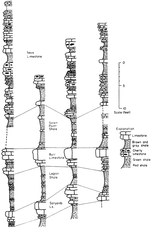
Table 1--Formations in the Council Grove Group, Lower Permian
| Chase Group | |
| Council Grove Group | |
| Speiser Shale | |
| Funston Limestone | |
| Blue Rapids Shale | |
| Crouse Limestone | |
| Easly Creek Shale | |
| Bader Limestone | |
| Stearns Shale | |
| Beattie Limestone | |
| Eskridge Shale | |
| GRENOLA LIMESTONE | |
| Roca Shale | |
| Red Eagle Limestone | |
| Johnson Shale | |
| Foraker Limestone | |
| Admire Group | |
Previous Study
The Grenola Limestone was not recognized as such during the early days of reconnaissance geology in Kansas. The first published reference to the Permian rocks of Kansas was by Swallow and Hawn (1858). Later, Swallow (1866), while working for the Kansas Geological Survey, published a report in which his "bed 84" was described as the "dry bone" limestone. This bed is now part of the Neva member. Swallow placed the Pennsylvanian-Permian boundary at the base of this bed. Hay (1893) included the present Grenola in what he called the Permo-Carboniferous, as he regarded the rocks from the Americus Limestone to the Fort Riley Limestone as transition beds between the Carboniferous and the Permian. The Neva member was thus involved in what has been termed the Pennsylvanian-Permian boundary dispute during the earliest days of Kansas geology.
Prosser (1895) included what is now the Grenola in his Wabaunsee Formation, which extended from what is now the Silver Lake Shale in the Sacfox Subgroup of the Waubaunsee Group to the base of the Cottonwood Limestone, in the present Beattie Limestone. This single stratigraphic unit of Prosser's classification now includes 34 recognized formations in Kansas and many more members. In the same year, Prosser (1895a) named the Neva Limestone, occurring 11 to 31 feet below the base of his Manhattan (==Cottonwood) Limestone. The placement of the present Grenola was not affected when Haworth (1896) moved the base of the Wabaunsee Formation upward to the base of the Burlingame Limestone. The reconnaissance nature of this early work may be realized by noting the statement by Haworth (1896):
"Throughout the whole of the Waubaunsee formation only one limestone is of any special interest, the heavy coarse looking system [Neva] lying about 30 feet below the Cottonwood Falls rock . . ."
In the same volume, Kirk (1896) applied the name Dunlap Limestone to the two strata occurring 20 to 25 feet below the "Cottonwood Falls rock." These limestone beds are separated by about 20 feet of blue shale. Condra and Busby (1933) did not regard this name as valid for the rocks they called the Grenola Formation, because Dunlap Limestone, as used by Kirk, seemingly included the upper part of the Red Eagle Limestone. Consequently, the name Dunlap Limestone was dropped.
In a revised classification of the upper Paleozoic of Kansas, Prosser (1902) included the present Grenola in the Missourian Series of the Upper Carboniferous and assigned it to the Wabaunsee Stage, the boundary between Wabaunsee and Council Grove deposits being placed at the base of the Cottonwood Limestone. Within this stage, he set up the Elmdale Formation, 130 feet thick, which extended from the top of the Americus Limestone to the base of the Neva Limestone. It may be seen that classification gradually became more refined as the recognition of beds became certain.
Bass (1929) included the Neva Limestone as a member of the Elmdale Formation, which by this time had been restricted in thickness to about 80 feet. Bass placed the lower boundary of the Permian at the base of the Cottonwood Limestone.
Condra and Busby (1933), studying Lower Permian strata in Nebraska, Kansas, and Oklahoma, gave the name Grenola Formation to the rocks previously termed Neva Limestone. The name Neva Limestone was restricted to the upper limestone member, and the names Salem Point Shale, Burr Limestone, Legion Shale, and Sallyards Limestone were given to the lower four limestone and shale members. This assignment is now in current use, although for several years after Condra and Busby's definitive paper the Kansas Geological Survey did not recognize the lower limestone and shale members (Sallyards Limestone and Legion Shale) but included them in the upper part of the Roca Shale.
Moore and Moss (1934) placed the Pennsylvanian-Permian boundary at the lower limit of the Indian Cave Sandstone member of the Towle Shale (Admire Group), thereby classifying the Grenola in the Lower Permian.
Techniques
Field Techniques
A lithologic sample of each limestone bed of the Grenola Limestone was collected at each locality where studies were made. Only one sample was taken where several 2- to 3-inch strata of limestone were indistinguishable in the field. The fauna of each bed was collected as completely as possible. The shale beds were sampled by digging a shallow trench and collecting the freshly exposed shale. Shales less than a foot thick were sampled as units, but thicker shale beds were sampled between color changes. Generally, shale partings less than 1 inch thick were not sampled. The top of each limestone sample was marked with drafting tape. Thicker strata of limestone, such as the upper massive bed of the Burr Limestone, were sampled at the top and bottom of the stratum.
All measurements of exposed rock were made with a steel tape and hand level. Covered intervals were measured with a hand level.
Laboratory Techniques
A portion of each shale sample was broken down and deflocculated; clay particles were decanted, and after the residue was dried slowly over a steam radiator it was examined for microfossils. Shales that disintegrated in water were not treated further, but indurated shales were soaked in water, boiled 15 or 20 minutes, and then the clay was decanted. A special procedure was used for the most indurated shales. They were soaked in kerosene for 10 to 20 minutes, the kerosene was poured off and water added, and the mixture allowed to stand overnight; most samples were reduced to a soft mud in that length of time. Some very calcareous shales would not break down by the kerosene method, and these were either mechanically crushed and re-treated with kerosene or classed as limestones. For convenience in examination, the washed shales were sieved into three sizes.
Some shales were treated by placing several small chips of fresh shale in a watch glass, covering them with water, and then adding 2 or 3 drops of hydrochloric acid. The degree of effervescence was noted, and when all carbonate material had been dissolved, the sample was washed and decanted several times to remove the clay fraction. Then the sample was dried and the coarse fraction examined for mineralogical composition.
The top of each limestone sample was marked with a grease pencil instead of the drafting tape used in the field. A slab, approximately 1.0 cm thick and perpendicular to the bedding, was cut from each limestone sample, and then one side of the slab was ground smooth with 500-grit carborundum powder. The smooth side then was etched 1 to 2 minutes in 5 percent hydrochloric acid. It was found that etching for longer periods of time created too much relief on the surface, so that carbonate material was partly hidden by high-standing noncarbonates. The sample was then gently dipped in a pan of water to remove the acid, and dried. Etching with weak acetic acid was tested, but this acid did not provide clear differentiation between matrix and organic particles.
Care was necessary in order that the etched surface was not rubbed in any way after preparation, for rubbing crumbles the delicate argillaceous or siliceous material that stands in relief.
Cellulose-acetate peels were made from some of the limestone slabs. Comparison of peels and slabs under a binocular microscope revealed that direct observation of etched surfaces was preferable. Peels in this study had two main shortcomings: (1) they did not show color contrasts, and (2) noncarbonate material could not be distinguished clearly from carbonate material. Limestone slabs do not show the microstructure of organic particles and are difficult to photograph. Both methods must be used for a complete study.
If etched surfaces showed osagite-like structures, a portion of the sample was broken up and dissolved in hydrochloric acid. In addition, thin sections were prepared of selected beds that contained algal-like structures.
Prev Page--Table of Contents || Next Page--Stratigraphy
Kansas Geological Survey, Geology
Placed on web June 4, 2007; originally published June 1958.
Comments to webadmin@kgs.ku.edu
The URL for this page is http://www.kgs.ku.edu/Publications/Bulletins/130_3/02_intro.html