Kansas Geological Survey, Bulletin 127, part 5, originally published in 1957
Prepared by the United States Geological Survey and the State Geological Survey of Kansas, with the cooperation of the Division of Sanitation of the Kansas State Board of Health and the Division of Water Resources of the Kansas State Board of Agriculture
Originally published in 1957 as Kansas Geological Survey Bulletin 127, part 5. This is, in general, the original text as published. The information has not been updated.
This report describes aquifer tests made in March 1954 and February and March 1955 to determine the coefficients of transmissibility and storage of the Ordovician rocks at Pittsburg, Kansas. The report includes most of the data obtained during the tests and the analysis of the data. The general regional decline of water level in the Ordovician rocks in the Tri-State district is discussed.
The Ordovician rocks are the most important water-bearing beds in the Pittsburg area. They are composed of dolomite, shale, sandy dolomite, and fine-grained sandstone. The rocks do not crop out in the Pittsburg area but crop out many miles to the east in Missouri. The main water-bearing beds lie at a depth of 600 to 1,050 feet at Pittsburg.
The average values of the coefficients of transmissibility and storage computed from the aquifer tests were 250,000 gallons per day (gpd) per foot and 4.6 X 10⁻⁴, respectively. The value of the coefficient of transmissibility is high compared to values obtained in other places where similar tests of the aquifer have been made.
To a considerable extent the decline of water level at Pittsburg probably has been due to pumping from mines in the overlying Mississippian rocks, as well as to pumping from the Ordovician rocks themselves.
A huge quantity of water is stored in the Ordovician rocks, which will continue to yield millions of gallons of water per day.
Pittsburg is in Crawford County in the southeastern part of Kansas. In 1930, Pittsburg had a population of 18,145; in 1940, 17,571; in 1950, 19,341; and in 1955, 20,992. The annual pumpage by the city has increased from 624.2 million gallons in 1949 to 736.4 million gallons in 1954. The city of Pittsburg was the only large user of ground water within the city in 1955.
Early in 1954 the city of Pittsburg considered substantially increasing the rate of pumping, but data were not available to determine what would happen to water levels in the area. As a part of the statewide investigation in cooperation with the State Geological Survey of Kansas, the Division of Sanitation of the Kansas State Board of Health, and the Division of Water Resources of the Kansas State Board of Agriculture, the U. S. Geological Survey made several aquifer (pumping) tests to determine the hydraulic properties of the water-bearing rocks in this area.
Theoretically, if the hydraulic properties of water-bearing formations are known or can be satisfactorily determined, the effects of increased pumping can be predicted. In March 1954 a short aquifer test was made in the Pittsburg well field. In February 1955 a well 14 inches in diameter (Pittsburg well 7) was completed and was used as a pumping well and as an observation well during several tests. A recovery test was made on this well after the test pump was shut down. After removal of the pump the well was used as an observation well to determine the degree of interference caused by pumping of other wells. These tests were made in order to check the coefficients of transmissibility and storage obtained in March 1954.
The tests were made possible through the cooperation and assistance of the officials of the city of Pittsburg, especially Lee Haworth, City Manager; O. R. Green, Water Superintendent; and D. A. MacCuaig, Assistant Water Superintendent. Excellent cooperation was given by the well- and water-plant operators of the City Water Department, as considerable rescheduling of operations was necessary so that the tests could be made under the best control possible.
A. L. Hornbaker of the State Geological Survey field office in Pittsburg assisted during the tests. The manuscript for this report has been reviewed by several members of the Federal and State Geological Surveys; by R. V. Smrha, Chief Engineer, and George S. Knapp, Engineer of the Division of Water Resources of the Kansas State Board of Agriculture; and D. F..Metzler, Director, and W. O. Hilton, Geologist, of the Division of Sanitation of the Kansas State Board of Health.
The towns in southeastern Kansas that pump water from the Ordovician rocks and the average daily pumpage of water during 1950 are given in Table 1. The rate of pumping was slightly greater in 1956 than in 1950.
Table 1--Average daily pumpage from Ordovician rocks by towns in southeastern Kansas, 1950. Data from Kansas State Board of Health.
| Town | Average daily pumpage, gallons |
|---|---|
| Arcadia | 60,000 |
| Arma | 40,000 |
| Baxter Springs | 350,000 |
| Cherokee | 80,000 |
| Columbus | 350,000 |
| Frontenac | 130,000 |
| Galena | 400,000 |
| Girard | 300,000 |
| McCune | 50,000 |
| West Mineral | 40,000 |
| Mulberry | 50,000 |
| Pittsburg | 1,700,000 |
| Scammon | 30,000 |
| Weir | 80,000 |
| Total | 3,660,000 |
The city of Pittsburg has provided the following information concerning its pumpage of ground water (Table 2).
Table 2--Pumpage by city of Pittsburg, 1949-54, in millions of gallons.
| Year | Annual pumpage | Average daily pumpage |
|---|---|---|
| 1949 | 624.2 | 1.7 |
| 1950 | 620.5 | 1.7 |
| 1951 | 615.8 | 1.7 |
| 1952 | 654.5 | 1.8 |
| 1953 | 674.9 | 1.9 |
| 1954 | 736.4 | 2.0 |
As indicated in Table 2, the increase in pumpage in Pittsburg was slight during that 5 years. The city water superintendent reported that the average pumpage since the water system was installed in 1882 has been about 1.4 mgd.
In nearby Ottawa County, Oklahoma, large amounts of water are pumped to keep the lead and zinc mines dry enough to work. Reed, Schoff, and Branson (1955, p. 85) estimated the total of such pumpage and of spring discharge from the Boone formation (Mississippian age) at about 28 million gallons per day.
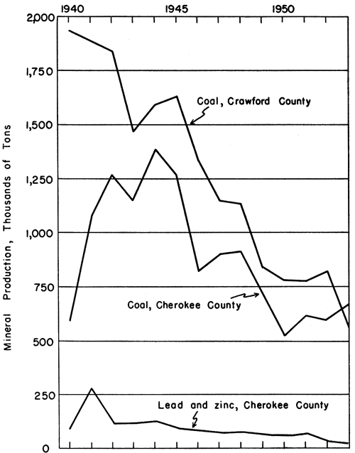
Figure 1 shows the production of coal, lead, and zinc in Cherokee and Crawford Counties in southeastern Kansas. Because a large quantity of ground water was pumped as a part of these mining operations, for washing coal and for mine drainage, this graph shows indirectly that the rate of water use has decreased during the last few years.
Figure 1--Coal, lead, and zinc production in Crawford and Cherokee Counties, Kansas.
Pittsburg is on the outcrop of the Cherokee shale, of Pennsylvanian age. The Pennsylvanian rocks overlie rocks of Mississippian age; the contact lies at a depth of 240 feet in Pittsburg well 7. The rocks of Mississippian age penetrated by this well consist mostly of cherty dolomite, limestone, and some shale. Below the Mississippian rocks, at a depth of 600 feet, lie rocks of Ordovician age, consisting mainly of cherty dolomite, some sandy dolomite, shale, and sandstone. The log of the rocks penetrated in drilling well 7 is given in Table 3. The Ordovician formations include, in descending order, the Cotter dolomite, Jefferson City dolomite, Roubidoux dolomite, Gasconade dolomite, and Van Buren formation. The first three constitute the main water-bearing zone, and the Roubidoux dolomite is regarded as the best water-bearing formation of the three.
Table 3--Log of Pittsburg well 7, at the SE corner sec. 19, T. 30 S., R. 25 E., Crawford County: drilled by E. J. Vaught Drilling Company, 1955. Samples studied by W. G. Hodson.
| Thickness, feet |
Depth, feet |
|||
|---|---|---|---|---|
| Pennsylvanian System | ||||
| Soil and fill | 5 | 5 | ||
| Clay, yellow | 20 | 25 | ||
| Shale, gray, trace of coal | 15 | 40 | ||
| Shale, gray, trace of coal, pyrite | 10 | 50 | ||
| Shale, gray, trace of coal | 50 | 100 | ||
| Shale, gray | 10 | 110 | ||
| Shale, gray, trace of coal | 10 | 120 | ||
| Shale, gray | 15 | 135 | ||
| Shale, gray, trace of coal | 5 | 140 | ||
| Shale, gray | 45 | 185 | ||
| Shale, gray, pyrite | 5 | 190 | ||
| Shale, gray | 50 | 240 | ||
| Mississippian System | ||||
| Shale, gray, cherty | 10 | 250 | ||
| Limestone, gray, gray shale, and chert | 20 | 270 | ||
| Limestone, gray | 10 | 280 | ||
| Limestone, gray, cherty | 10 | 290 | ||
| Limestone, gray, containing pyrite and glauconite | 80 | 370 | ||
| Limestone, gray, cherty | 5 | 375 | ||
| Dolomite, gray, cherty | 25 | 400 | ||
| Dolomite, gray, containing pyrite and glauconite | 25 | 425 | ||
| Dolomite, gray, cherty | 5 | 430 | ||
| Limestone, gray, and gray dolomite, cherty | 10 | 440 | ||
| Limestone, gray, and gray dolomite | 10 | 450 | ||
| Limestone | 10 | 460 | ||
| Limestone, cherty | 85 | 545 | ||
| Limestone, gray | 10 | 555 | ||
| Shale, gray, calcareous | 20 | 575 | ||
| Limestone, gray | 15 | 590 | ||
| Limestone, gray, containing pyrite and limonite | 10 | 600 | ||
| Ordovician System | ||||
| Cotter and Jefferson City dolomites, undifferentiated | ||||
| Dolomite, gray, containing limonite | 15 | 615 | ||
| Dolomite, gray, cherty | 20 | 635 | ||
| Dolomite, gray; limonite | 35 | 670 | ||
| Dolomite, gray, cherty | 135 | 805 | ||
| Dolomite, gray | 25 | 830 | ||
| Dolomite, gray, cherty | 85 | 915 | ||
| Dolomite, gray | 10 | 925 | ||
| Dolomite, gray, sandy | 10 | 935 | ||
| Dolomite, gray | 30 | 965 | ||
| Dolomite, gray, cherty | 10 | 975 | ||
| Roubidoux dolomite | ||||
| Dolomite, gray, sandy | 10 | 985 | ||
| Sand, medium, white | 15 | 1,000 | ||
| Shale, dark gray | 5 | 1,005 | ||
| Dolomite, gray | 30 | 1,035 | ||
| Dolomite, gray, sandy | 10 | 1,045 | ||
| Dolomite, gray, sandy, cherty | 5 | 1,050 | ||
| Gasconade dolomite and Van Buren formation, undifferentiated | ||||
| Dolomite, gray | 25 | 1,075 | ||
| Dolomite, gray, cherty | 158 | 1,233 | ||
| Total depth | 1,233 | |||
Abernathy (1941, p. 232) comments on the Cotter and Jefferson City dolomites as follows:
At one time in the geologic past, this rock lay at or near the surface and was extensively dissolved. This produced a very porous, leached zone at or near the surface of the dolomite beds. The porous rock has since been covered by hundreds of feet of other strata and the solution formed cavities are now filled with water. . . . Several hundred deep wells have penetrated the water-bearing zones of the Cotter dolomite and Jefferson City dolomite beds in eastern Kansas and northern Oklahoma, and every such well finds an abundance of water in it.
The Roubidoux dolomite comprises interbedded dolomite, sandy dolomite, and partly cemented sandstone. It is the principal water-bearing formation in most of southern Missouri, extreme southeastern Kansas, and northeastern Oklahoma.
The thickness of the Roubidoux dolomite penetrated in well 7 is 75 feet. Abernathy (1943, p. 88) reported a thickness of 155 feet in the Jayhawk Ordnance Plant well at Galena, Kansas. Reed, Schoff, and Branson (1955, p. 41) reported that in Ottawa County, Oklahoma, the thickness of the Roubidoux dolomite ranges from 105 to 180 feet and averages 160 feet.
The combined thickness of the Cotter dolomite and Jefferson City dolomite in well 7 is 375 feet. Reed, Schoff, and Branson (1955, p. 42-44) reported that in Ottawa County, Oklahoma, the average thickness of the Cotter dolomite is 165 feet and of the Jefferson City dolomite is 295 feet, a total of 460 feet. Hence, the Ordovician rocks seem to be thinner in the Pittsburg area than they are farther south.
The Gasconade dolomite and Van Buren formation, which lie below the Roubidoux dolomite, are penetrated by the Pittsburg wells but are not believed to be a source of much water.
The Ordovician rocks in the Pittsburg area dip westward about 18 to 20 feet to the mile. The nearest outcrop of the Roubidoux dolomite is about 90 miles to the east. The water in the Ordovician rocks originates in precipitation that falls on and enters the outcrops in Missouri. The water migrates slowly down the dip of the rocks and becomes confined in the porous zones by relatively impervious layers above and below, although a hydraulic interconnection probably exists throughout the Ordovician rocks in such a way that the system acts in general as a complex hydraulic unit; therefore, any specific zone may receive recharge downdip from its outcrop.
In Pittsburg wells 1, 2, and 3 only the Pennsylvanian rocks are cased off, and the water may be derived from both the Mississippian and Ordovician rocks. In well 7 all except the lower 16 feet of the Mississippian rocks is also cased off. The casing length is respectively 250 feet, 325 feet, 293 feet, and 584 feet in wells 1, 2, 3, and 7. Water can enter the wells from all water-bearing zones below the casing, but the amount of water being contributed to the wells by individual zones is not known.
The water in the Ordovician rocks in the Pittsburg area is confined by relatively impermeable rocks, and the water levels in wells rise above the top of the water-bearing materials. Thus, artesian conditions prevail in the Ordovician rocks, the hydrostatic pressure in the confined part of the aquifer being caused by the higher level of water in the intake area. This artesian aquifer is saturated at all times, even while water is being pumped from the wells.
Eight aquifer tests were run at Pittsburg in March 1954 and in February and March 1955. Aquifer tests consisted of pumping a well and measuring the amount and rate of change in water level in observation wells or recording the recovery of the water level after pumping stopped. Water levels were measured during these tests by means of an electric tape. Discharge measurements were read from a master meter in the filter plant.
Owing to the necessity of maintaining pumping schedules for supplying Pittsburg with water, none of the tests could be continued as long as desired. The tests in February and March 1955 were made under better control conditions than those in 1954. Well 7 was completed in February 1955, and during the acceptance pumping test by the driller, water levels were measured in the pumped well. After this test was completed, the pump was shut off and recovery of the water level was measured in the pumped well.
Later, the test pump on well 7 was removed and an automatic water-stage recorder was installed in the well. Wells 1, 2, and 3 were each pumped for a given period, and a continuous record of drawdown or recovery in well 7 was obtained with the recorder. Figure 2 shows the location of the wells used in the tests. Table 4 gives the rate of pumping, the distance of the observation well from the pumped well, and whether the aquifer test was based on drawdown or recovery measurements. Tables 5 through 12 list pertinent parts of the test data.
Figure 2--Map of Pittsburg well field showing location of wells used in aquifer tests.
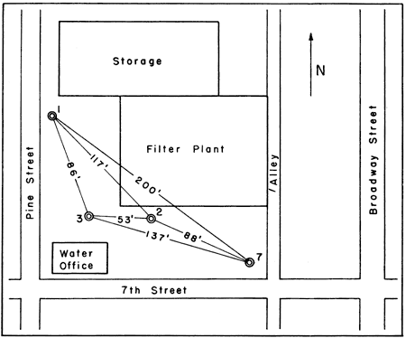
Table 4--Aquifer tests made at Pittsburg, Kansas.
| Aquifer test no. |
Date | Pumped well turned on or off |
Observation well |
Distance of observation well from pumped well (r), ft. |
Rate of pumping, gpm |
|---|---|---|---|---|---|
| 1 | 3-20-1954 | 2 off | 1 | 117 | 800 |
| 2 | 3-20-1954 | 1 on | 3 | 86 | 700 |
| 3 | 2-15-1955 | 7 on | 7 | 860 | |
| 4 | 3-2-1955 | 3 off | 7 | 137 | 460 |
| 5 | 3-2-1955 | 1 on | 7 | 200 | 750 |
| 6 | 3-2-1955 | 1 off | 7 | 200 | 750 |
| 7 | 3-3-1955 | 3 on | 7 | 137 | 460 |
| 8 | 3-3-1955 | 2 off | 7 | 88 | 750 |
Table 5--Recovery of water level in well 1 during aquifer test 1 using well 2 on March 20, 1954.
| Time since pumping stopped (t') in well 2, in minutes |
Recovery (s) in well 1, in feet |
Time since pumping stopped (t') in well 2, in minutes |
Recovery (s) in well 1, in feet |
|---|---|---|---|
| 4 | 0.84 | 15 | 1.10 |
| 5 | 0.87 | 20 | 1.14 |
| 6 | 0.91 | 25 | 1.24 |
| 7 | 0.93 | 30 | 1.31 |
| 8 | 0.96 | 35 | 1.35 |
| 9 | 0.98 | 40 | 1.41 |
| 10 | 1.01 | 50 | 1.48 |
| 11 | 1.03 | 60 | 1.55 |
| 12 | 1.04 |
Table 6--Drawdown of water level in well 3 during aquifer test 2 using well 1 on March 20, 1954.
| Time since pumping started (t) in well 1, in minutes |
Drawdown (s) in well 3, in feet |
Time since pumping stopped (t) in well 1, in minutes |
Drawdown (s) in well 3, in feet |
|---|---|---|---|
| 5.5 | 1.23 | 20 | 1.55 |
| 7.5 | 1.29 | 22 | 1.58 |
| 10 | 1.36 | 24 | 1.62 |
| 12 | 1.39 | 29 | 1.66 |
| 14 | 1.43 | 39 | 1.76 |
| 16 | 1.48 | 49 | 1.82 |
| 18 | 1.51 |
Table 7--Depth to water in pumped well 7 during aquifer test 3 on February 15, 1955.
| Time since pumping stopped (t') in well 7, in minutes |
Depth to water (dw) in pumped well 7, in feet |
Time since pumping stopped (t') in well 7, in minutes |
Depth to water (dw) in pumped well 7, in feet |
|---|---|---|---|
| Static water level | 246.00 | 25 | 247.26 |
| 2 | 248.35 | 35 | 247.17 |
| 3 | 248.21 | 47 | 247.02 |
| 4 | 248.10 | 63 | 246.95 |
| 5 | 247.98 | 88 | 246.85 |
| 7 | 247.80 | 113 | 246.80 |
| 10 | 247.62 | 175 | 246.60 |
| 15 | 247.50 |
Table 8--Recovery of water level in well 7 during aquifer test 4 using well 3 on March 2, 1955.
| Time since pumping stopped (t') in well 3, in minutes |
Recovery (s) in well 7, in feet |
Time since pumping stopped (t') in well 3, in minutes |
Recovery (s) in well 7, in feet |
|---|---|---|---|
| 4 | 0.72 | 25 | 0.99 |
| 5 | 0.75 | 30 | 1.01 |
| 6 | 0.77 | 35 | 1.03 |
| 7 | 0.78 | 40 | 1.06 |
| 8 | 0.79 | 45 | 1.08 |
| 9 | 0.81 | 50 | 1.10 |
| 10 | 0.83 | 55 | 1.11 |
| 12 | 0.86 | 60 | 1.12 |
| 14 | 0.89 | 75 | 1.17 |
| 16 | 0.91 | 85 | 1.19 |
| 18 | 0.93 | 90 | 1.20 |
| 22 | 0.96 | 100 | 1.22 |
Table 9--Drawdown of water level in well 7 during aquifer test 5 using well 1 on March 2, 1955.
| Time since pumping started (t) in well 1, in minutes |
Drawdown (s) in well 7, in feet |
Time since pumping stopped (t) in well 1, in minutes |
Drawdown (s) in well 7, in feet |
|---|---|---|---|
| 1 | 0.77 | 25 | 1.72 |
| 1.25 | 0.80 | 30 | 1.78 |
| 1.50 | 0.84 | 35 | 1.83 |
| 1.75 | 0.88 | 40 | 1.88 |
| 2 | 0.91 | 45 | 1.92 |
| 2.25 | 0.94 | 50 | 1.95 |
| 2.50 | 0.97 | 55 | 1.99 |
| 2.75 | 1.00 | 60 | 2.02 |
| 3 | 1.02 | 65 | 2.05 |
| 3.25 | 1.04 | 70 | 2.08 |
| 3.50 | 1.07 | 75 | 2.11 |
| 3.75 | 1.09 | 80 | 2.14 |
| 4 | 1.11 | 90 | 2.17 |
| 4.50 | 1.14 | 100 | 2.20 |
| 5 | 1.18 | 110 | 2.24 |
| 5.50 | 1.21 | 120 | 2.26 |
| 6 | 1.24 | 130 | 2.29 |
| 6.50 | 1.27 | 140 | 2.32 |
| 7 | 1.29 | 150 | 2.35 |
| 7.50 | 1.32 | 160 | 2.37 |
| 8 | 1.34 | 170 | 2.39 |
| 9 | 1.38 | 180 | 2.41 |
| 10 | 1.41 | 190 | 2.43 |
| 11 | 1.44 | 200 | 2.45 |
| 12 | 1.47 | 220 | 2.49 |
| 13 | 1.50 | 240 | 2.51 |
| 15 | 1.54 | 270 | 2.54 |
| 17 | 1.59 | 300 | 2.56 |
| 20 | 1.65 |
Table 10--Recovery of water level in well 7 during aquifer test 6 using well 1 on March 2, 1955.
| Time since pumping stopped (t') in well 1, in minutes |
Recovery (s) in well 7, in feet |
Time since pumping stopped (t') in well 1, in minutes |
Recovery (s) in well 7, in feet |
|---|---|---|---|
| 4 | 1.32 | 21 | 1.66 |
| 5 | 1.35 | 23 | 1.69 |
| 6 | 1.38 | 25 | 1.72 |
| 7 | 1.40 | 27 | 1.74 |
| 8 | 1.43 | 30 | 1.77 |
| 9 | 1.45 | 36 | 1.82 |
| 10 | 1.47 | 40 | 1.85 |
| 11 | 1.49 | 45 | 1.88 |
| 13 | 1.53 | 50 | 1.92 |
| 15 | 1.56 | 55 | 1.95 |
| 17 | 1.60 | 60 | 1.98 |
| 19 | 1.63 |
Table 11--Drawdown of water level in well 7 during aquifer test 7 using well 3 on March 3, 1955.
| Time since pumping started (t) in well 3, in minutes |
Drawdown (s) in well 7, in feet |
Time since pumping stopped (t) in well 3, in minutes |
Drawdown (s) in well 7, in feet |
|---|---|---|---|
| 3 | 0.60 | 18 | 0.89 |
| 4 | 0.64 | 20 | 0.91 |
| 5 | 0.67 | 22 | 0.93 |
| 6 | 0.70 | 25 | 0.95 |
| 7 | 0.72 | 30 | 0.99 |
| 8 | 0.75 | 35 | 1.01 |
| 9 | 0.77 | 40 | 1.03 |
| 10 | 0.79 | 45 | 1.04 |
| 11 | 0.81 | 50 | 1.07 |
| 12 | 0.82 | 60 | 1.10 |
| 13 | 0.83 | 70 | 1.12 |
| 14 | 0.84 | 85 | 1.16 |
| 16 | 0.87 | 100 | 1.18 |
Table 12--Recovery of water level in well 7 during aquifer test 8 using well 2 on March 3, 1955.
| Time since pumping stopped (t') in well 2, in minutes |
Recovery (s) in well 7, in feet |
Time since pumping stopped (t') in well 2, in minutes |
Recovery (s) in well 7, in feet |
|---|---|---|---|
| 4 | 1.31 | 31 | 1.86 |
| 5 | 1.35 | 35 | 1.90 |
| 6 | 1.38 | 40 | 1.95 |
| 7 | 1.42 | 45 | 1.97 |
| 8 | 1.46 | 50 | 2.01 |
| 9 | 1.49 | 58 | 2.05 |
| 10 | 1.52 | 60 | 2.06 |
| 11 | 1.55 | 65 | 2.09 |
| 12 | 1.57 | 70 | 2.12 |
| 13 | 1.59 | 75 | 2.15 |
| 14 | 1.61 | 80 | 2.16 |
| 15 | 1.64 | 90 | 2.20 |
| 17 | 1.68 | 100 | 2.25 |
| 19 | 1.71 | 120 | 2.30 |
| 21 | 1.74 | 135 | 2.36 |
| 24 | 1.77 | 150 | 2.39 |
| 27 | 1.81 | 165 | 2.42 |
When a pump begins to discharge water, the water level is lowered, a hydraulic gradient is established toward the well from all radial directions, and the piezometric surface is lowered around the well. The horizontal area under which the piezometric level declines is called the area of influence. The cone of depression underlies the area of influence, and its deepest point is at the well. As long as pumping continues in excess of recharge, the cone of depression will deepen and expand. When pumping stops, the water level in a well will recover at a rate similar to the rate of decline. The amount and rate of decline of the water level during pumping, or of recovery of the water level after pumping stops, depend on the hydraulic properties of the aquifer. These properties are related to the ability of the aquifer to transmit water and to the amount of water released from or taken into storage in the aquifer when the head is changed. The hydraulic properties of particular interest are termed the coefficient of transmissibility (T) and the coefficient of storage (S).
The coefficient of transmissibility may be defined as the number of gallons of water that will move in one day through a vertical strip of the aquifer one mile wide, having a height equal to the full saturated thickness of the aquifer, under a hydraulic gradient of one foot per mile. The coefficient of storage of an aquifer is defined as the volume of water it releases from or takes into storage per unit surface area of the aquifer per unit change in the component of head normal to that surface.
To determine the coefficients of transmissibility and storage, the data from the aquifer tests were analyzed in accordance with the Theis nonequilibrium formula and the Cooper-Jacob modified nonequilibrium formula.
Theis (1935) developed the following nonequilibrium formula through analogy between the flow of ground water and the flow of heat by conduction:
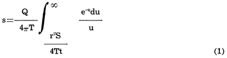
where u=r2S/4Tt. Equation (1) is the fundamental nondimensional form derived by Theis. If the several factors are expressed in units commonly used by the U. S. Geological Survey, the equation then assumes the following form:
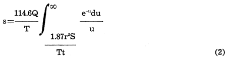
where u=1.87r2S/Tt; s is the drawdown or recovery, in feet, at any point within the cone of depression; Q is the discharge of the pumped well, in gallons per minutes; T is the coefficient of transmissibility, in gallons per day per foot; S is the coefficient of storage; r is the distance of the observation point from the pumped well, in feet; and t is the time since pumping started or stopped, in days. The Theis formula is based on theoretical conditions that rarely, if ever, exist in nature, but by use of judgment in obtaining and interpreting the data, reasonably valid results are obtainable. Thus, even though the water-bearing formations in the Pittsburg area are not homogeneous, as assumed in the derivation of the formula, it seems probable that enough hydraulic interconnection exists throughout the aquifer to allow the determination of average values of the coefficients of transmissibility and storage. The agreement in values obtained from the several tests suggests that reasonably reliable T and S values can be obtained from tests made in the Ordovician rocks in the Pittsburg area.
The exponential integral, in equation (2) may be replaced by the term W (u), which is read "well function of u", and the equation rewritten as
s = (114.6Q / T)W(u) (equation 3)
The value of W (u) is given by the series
W(u) = { -0.5772 - logeu + u - (u2 / 2·2!) + (u3 / 3·3!) . . .} (equation 4)
Values of W(u) for selected values of u are given by Wenzel (1942) and Ferris (1951).
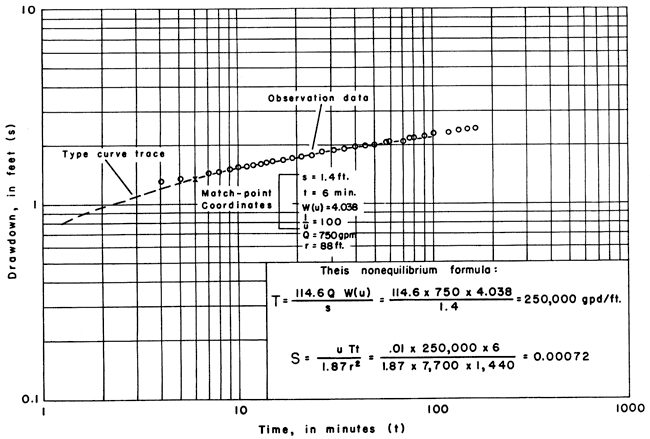
If s is measured in one or preferably more than one observation well for several values of t, and if the discharge (Q) of the pumped well is known, T and S can be determined. Theis devised a graphical method to obtain a simple solution of his equation. If values of W(u) are plotted against 1/u on logarithmic paper, a type curve is obtained, a segment of which is shown in Figure 3. Values of drawdown (s) observed during the test are plotted against corresponding values of elapsed pumping time on logarithmic paper of the same scale as the type curve. The drawdown scale relates to the W(u) scale, and the time scale to the 1/u scale. Time values are often conveniently plotted in minutes, and the time-drawdown curve is plotted on translucent paper for superposition on the graph of the type curve. The observed curve can be fitted to the type curve in only one place when the coordinate axes of the two curves are kept parallel. With both curves at the best match position, a point anywhere on the graph is selected and its two pairs of coordinates noted. Substitution of the values for s and W(u) in equation (3) permits solving for T. Substitution of the values of t, 1/u, and T in the relation for u permits solving for S. Figure 3 illustrates the determination of coefficients of transmissibility and storage from the data obtained in aquifer test 8.
Figure 3--Graph for determining coefficients of transmissibility and storage from aquifer test 8 using Pittsburg wells 2 and 7.
Cooper and Jacob (1946) pointed out that when u in the Theis nonequilibrium formula becomes small (less than 0.01) the sum of the terms in W(u) beyond logeu becomes insignificant. Evidently u decreases as the time, t, increases, and thus for large values of t equation (4) may be satisfactorily approximated as W(u)=-0.5772-logeu. Substitution of this modified form of W (u) in equation (3) yields the expression
s = (114.6Q / T)(-0.5772 = logeu) (equation 5)
Equation (5) can be solved graphically in the following manner. Values of drawdown or recovery, measured in an observation well, are plotted as ordinates on the arithmetic scale and values of time as abscissas on the logarithmic scale of semilog paper. The semilog plot will yield a straight line in the region where u is smaller than 0.01. The slope of the straight line is used to calculate the coefficient of transmissibility. This same method can be used to determine T from drawdown or recovery measurements made in a pumped well, but the results are not always as reliable as they are when the data are obtained from observation wells.
Equation (5) reduces by mathematical treatment to the following form:
T = 264Q [log10(t2 / t1)] / (s2 - s1) (equation 6)
where s2 and s1 are drawdowns observed in an observation well at times t2 and t1 respectively. The Cooper-Jacob modified nonequilibrium formula is a more convenient method of obtaining a solution, provided u is less than 0.01.
For convenience, t1 and t2 may be chosen one log cycle apart, whereby the expression log10 t2/t1 equals 1, and thus equation (6) reduces to
T = 264Q / (s2 - s1) (equation 7)
Generally s2 - s1 is written as Δs where Δs is the difference in drawdown per log cycle, in feet.
The extrapolation of the straight line to the point of zero drawdown permits the calculation of the storage coefficient by the following formula
S = 0.3Tt0 / r2 (equation 8)
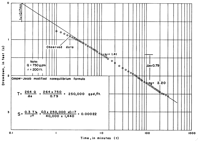
where S, T, and r have the meaning and units previously defined, and t0 is the time at zero drawdown, in days. Figure 4 gives the set of time-drawdown data from test 5 analyzed by this method.
Figure 4--Graph for determining coefficients of transmissibility and storage from aquifer test 5 using Pittsburg wells 1 and 7.
Both the nonequilibrium and modified nonequilibrium methods have advantages and disadvantages. Theoretically, the earliest data should be valid when the nonequilibrium formula is used, but in the Pittsburg tests the data for the first few minutes of drawdown and recovery were not valid. When the pump was turned off, the column of water (about 250 feet) flowed back down the well, and for a few minutes this surge of water affected the rate of recovery. The water level in the well rose to a peak and then declined before assuming the normal recovery trend.
When pumping began in a well, a reciprocal phenomenon occurred. Immediately after the pump was started it worked against less than total head until the pump column and discharge line became full. Thus, initially the well discharged at a rate greater than the stated rate, and the decline was excessive. After a few minutes of pumping, the normal drawdown trend developed, and the data became valid. Figure 3 indicates that the drawdown during the first few minutes was too large and later became asymptotic to the type curve. In the test, most of the drawdown occurred during the period before the data were valid. Thus the usable segment of the curve is so flat that it is difficult to match to the type curve.
When the modified nonequilibrium formula was used, the errors noticed above were not significant, because the early data, in the region where u is larger than 0.01, were not valid anyway. The advantage of the semilog method is that the valid data plot as a straight line. Thus, the chance for error in the determination of T was much less than by the type-curve method.
Determination of the storage coefficient by use of the modified nonequilibrium method may involve appreciable error. The zero-drawdown intercept is poorly defined if the angle of interception is small. In these tests they occur where the values of t are very small, and minor deviations in extrapolating the straight line will result in large percentage differences in computed values of the coefficient of storage.
Some other sources of error were present during the course of these tests. For example, the wells are all close together, and possible small errors in r between the bottoms of the wells could cause variations in S; the yields of the wells may not have been measured accurately; although the test periods were short, some error may have been caused by barometric changes; the amounts of uncased hole in the wells are slightly different and could have caused some differences in the computation of T and S.
The possible presence of aquifer boundaries was considered. Evidence suggests that in the Pittsburg area a change of permeability of the Ordovician rocks, from a high value to a lower value, may effectively limit the expansion of the cone of depression. The shortness of the tests, however, did not permit any evaluation of the effective position of the possible boundaries. Much longer tests would have been desirable, but wells could not be operated continuously for long periods without disrupting municipal requirements. A summary of the results obtained from the aquifer tests is given in Table 13.
Table 13--Coefficients of transmissibility and storage obtained by eight aquifer tests at Pittsburg, Kansas.
| Aquifer test no. |
Coefficient of transmissibility, gpd/ft |
Coefficient of storage |
|---|---|---|
| 1 | 260,000 | 2.7 x 10⁻³ |
| 2 | 240,000 | 1.1 x 10⁻³ |
| 3 | 250,000 | |
| 4 | 250,000 | 2.2 x 10⁻⁴ |
| 5 | 250,000 | 2.2 x 10⁻⁴ |
| 6 | 260,000 | 1.6 x 10⁻⁴ |
| 7 | 260,000 | 5.4 x 10⁻⁴ |
| 8 | 250,000 | 7.2 x 10⁻⁴ |
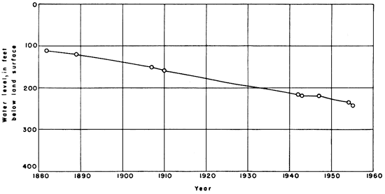
In the Pittsburg well field, the water level in 1882, when the first well was drilled, was reported to be 110 feet below the land surface. In March 1954 the water level in well 3 was 237 feet below the land surface. The changes in water level in the Pittsburg well field from 1882 to 1955 are shown on Figure 5. Only a few recorded measurements are available, but Figure 5 indicates a fairly steady rate of decline of water level in the Pittsburg well field from 1882 to 1955.
Figure 5--Decline of water level in Pittsburg well field from 1882 to 1954.
The decline in water level probably reflects not only the pumping of wells developed in the Ordovician rocks of the Tri-State district, but also the withdrawal of water from the overlying Mississippian rocks. Abernathy (1941, p. 234) reported on an extensive pumping test made by the Eagle-Picher Mining and Smelting Company at its Garrett lease in sec. 36, T. 34 S., R. 25 E., Cherokee County, Kansas, where the aquifer involved was the Reeds Spring formation (Mississippian). During a 67-day period, 482 million gallons of water was pumped from a shaft 5 by 9 feet in cross section and 465 feet deep. The water in the shaft was lowered from a level of 180 feet below the land surface on August 9, 1938, to 324.8 feet on March 7, 1939.
Reed, Schoff, and Branson (1955, p. 90) commented as follows on the decline of artesian pressure in the Ordovician rocks in Ottawa County, Oklahoma:
Most of the wells that originally flowed at the surface are reported to have ceased flowing "when the mines opened", probably in the period 1916 to the early 1920's when the production of lead and zinc ores increased rapidly. The mining operations could not have directly affected the artesian head of the water in the rocks of the Canadian series because the ore is found in rocks separated from them at most places by the essentially impervious Chattanooga shale. The hydrologic connection, if any, is very poor. The effect of increasing production of lead and zinc was a considerable increase in water use. The milling operations required large amounts of water, and, although most of it was obtained from surface ponds, many deep wells were drilled to supplement the ponds. At the same time, the cities and towns of the mining areas doubled and even trebled in population, most of the municipal wells were drilled, and municipal pumpage increased sharply. As the original artesian head was not much more than 30 feet above the land surface and the decline already was in progress, the increased draft caused the piezometric surface to fall below the land surface and the wells stopped flowing.
The aquifers in the Ordovician rocks are interconnected, and seemingly the Mississippian rocks and Ordovician rocks also are interconnected hydraulically in the Tri-State district; otherwise it would be difficult to explain the great decline in water level that has occurred. Although Reed, Schoff, and Branson regarded the Boone formation of Mississippian age as a separate aquifer in Ottawa County, Oklahoma, they suggested (1955, p. 136) that at some places there should be interconnection with the Ordovician rocks below it: "Where the Chattanooga shale is missing and possibly no impervious layer exists under the mines, the acidic waters may work their way down into the water-bearing strata of the Canadian series." According to Wallace Lee of the Kansas Geological Survey (personal communication), no Chattanooga shale was penetrated in Pittsburg well 7. Thus, it seems reasonable that pumping from the Mississippian and Ordovician rocks in parts of the Tri-State district has had some effect on water levels in all the water-bearing rocks of the area.
The Pittsburg water superintendent estimated that the use of water between 1882 and 1955 averaged 1.4 mgd. Available records indicate that the water level declined about 124 feet in the Pittsburg well field during this period of 73 years.
Values of 250,000 gpd/ft for the coefficient of transmissibility and 4.6 X 10⁻⁴ for the coefficient of storage were substituted in the Theis nonequilibrium formula to compute the decline in water level that should have resulted from pumping by the city of Pittsburg over the 73-year period if the aquifer were of infinite extent. It was assumed that all water pumped came from one well of 12-inch diameter at a constant rate of 1.4 mgd for 73 years and that all water pumped came from storage. The drawdown, under these assumed conditions, should have been 13.4 feet. The drawdown in the well field during this period exceeded the amount calculated in response to pumping by Pittsburg by slightly more than 100 feet. It is concluded that other discharge and the relatively small areal extent of the very permeable part of the aquifer have caused most of the decline in water level in the Pittsburg well field.
The available data on municipal wells near Pittsburg indicate that the transmissibility of the aquifer at Pittsburg is greater than at any other known place utilizing the same aquifer. Jacobson and Reed (1944, unpublished memorandum) made controlled aquifer tests using wells owned by the B. F. Goodrich Company at Miami, Oklahoma, about 35 miles south of Pittsburg, and obtained a value for T of about 40,000 gpd/ft. Abernathy (1943) reported that a 10-inch well at the Jayhawk Ordnance Plant 20 miles south of Pittsburg yielded 698 gpm and had a specific capacity of 3.2 gpm/ft of drawdown. The specific capacity obtained in Pittsburg well 1, which is of comparable size, was 75 gpm/ft of drawdown, and the T obtained at Pittsburg has been shown to be about 250,000 gpd/ft.
These data indicate that in nearby areas well performance and hence aquifer permeability are not so good as at Pittsburg. It seems quite possible, therefore, that the very permeable part of the aquifer may be terminated near Pittsburg by transition to zones of much less permeability. If this is true, then the boundary effects that are involved should be considered in developing water supplies from this aquifer. The boundary effects were not evident in the foregoing short aquifer tests; obviously, much longer tests would have been desirable. A lower transmissibility of the aquifer in other parts of the Tri-State district, however, will only partly explain the difference between observed and calculated water-level decline.
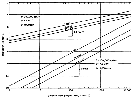
The drawdown produced by a well discharging at a rate of 1,000 gpm for aquifers having a coefficient of transmissibility of 250,000 and 100,000 gpd/ft respectively and a coefficient of storage of 4.6 x 10⁻⁴ is given in Figure 6. If the coefficient of transmissibility were only 100,000 at Pittsburg, the resulting drawdown after 50 years would be less than 12 feet at a distance of 2 miles.
Figure 6--Graph showing relation between drawdown, time, and distance for two aquifers having coefficients of transmissibility of 250,000 and 100,000 gpd/ft respectively and coefficient of storage of 4.6 x 10⁻⁴.
The many millions of gallons of water produced in the past from the Ordovician rocks and the rocks above them throughout the Tri-State district for municipal use and for mine dewatering and operation must be considered in analyzing water-level decline. It seems probable that the Mississippian and Ordovician rocks are hydraulically connected in some places in the Tri-State district. The amount of pumping from the Ordovician rocks in the Tri-State district, although great, has not been sufficient to account completely for the observed great decline in water level in these rocks. The pumping of very great quantities of water to drain mines throughout the Tri-State district has resulted in a broad regional decline in water level in the Mississippian rocks, and a related water-level decline in the underlying Ordovician rocks seems likely. A hydraulic connection between the Mississippian and Ordovician rocks helps to explain the decline in water level in the Pittsburg well field. When mines are shut down, pumping of water from them is stopped, and they gradually fill with water. The decline in mining operations and a corresponding decline in the use of water may result eventually in some recovery of water levels in the Tri-State district.
If the rate of water use by the city of Pittsburg continues to increase the water level will continue to decline slightly unless there is decreased pumping of water from mines.
Abernathy, G. E. (1941) Ground-water resources of Mississippian and older rocks in Bourbon, Crawford, Cherokee, and Labette Counties, southeastern Kansas: Kansas Geol. Survey, Bull. 38, pt. 8, p. 221-236, fig. 1. [available online]
Abernathy, G. E. (1943) Deep water well at the Jayhawk Ordnance Works in Cherokee County, Kansas: Kansas Geol. Survey, Bull. 47, pt. 3, p. 77-112, fig. 1-3, pl. 1. [available online]
Cooper, H. H., Jr., and Jacob, C. E. (1946) A generalized graphical method for evaluating formation constants and summarizing well-field history: Am. Geophys. Union Trans., v. 27, p. 526-534, fig. 1-5.
Ferris, J. G. (1951) Ground Water, Chapter 7; in, Hydrology, C. O. Wisler and E. F. Brater: New York, John Wiley & Sons, Inc., p. 198-273, fig. 62-98.
Jacob, C. E. (1946) Drawdown test to determine effective radius of artesian well: Am. Soc. Civil Engineers Proc., v. 72, no. 5, p. 629-646.
Reed, E. W., and Schoff, S. L. (1952) Aquifers in Ottawa County, Oklahoma: Oklahoma Acad. Sci., v. 33, p. 194-195.
Reed, E. W., Schoff, S. L., and Branson, C. C. (1955) Ground-water resources of Ottawa County, Oklahoma: Oklahoma Geol. Survey, Bull. 72, p. 1-203, fig. 1-14, pl. 1.
Theis, C. V. (1935) The relation between the lowering of the piezometric surface and the rate and duration of discharge of a well using groundwater storage: Am. Geophys. Union Trans., pt. 2, p. 519-524.
Wenzel, L. K. (1942) Methods for determining permeability of water-bearing materials: U. S. Geol. Survey, Water-Supply Paper 887, p. 1-192, fig. 1-17, pl. 1-6. [available online]
Kansas Geological Survey, The Hydraulic Properties of the Ordovician Rocks at Pittsburg, Kansas
Placed on web Jan. 19, 2009; originally published in December 1957.
Comments to webadmin@kgs.ku.edu
The URL for this page is http://www.kgs.ku.edu/Publications/Bulletins/127_5/index.html