Kansas Geological Survey, Bulletin 119, Part 5, originally published in 1956
Originally published in 1956 as Kansas Geological Survey Bulletin 119, Part 5. This is, in general, the original text as published. The information has not been updated. An Acrobat PDF version (2 MB) is also available.
A few minutes before 6 a.m. on January 6, 1956, south-central Kansas experienced the strongest earthquake to occur in the state since 1929. It was reported felt in south-central Kansas and northcentral Oklahoma; from Dodge City, Kansas, approximately 200 km (125 miles) east to Garden Plain, Kansas, and from Great Bend, Kansas, approximately 230 km (145 miles) south to Longdale, Oklahoma. The maximum effect was felt in the area delimited by Pratt and Coldwater, Kansas, and Alva, Oklahoma.
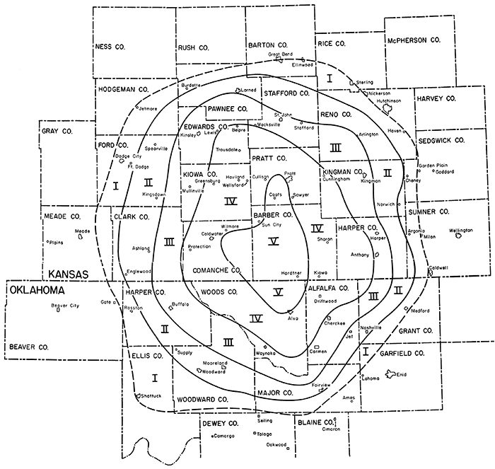
During this investigation the effects of the earthquake were determined and isoseismal lines were drawn (Fig. 1). The area was visited during the period of January 23 to 25, at which time residents in approximately 50 towns were questioned. The greatest amount of time was spent in the zones of intensity III to V (Modified Mercalli Intensity Scale of 1931). The early hour of occurrence hampered the investigation' somewhat, for it was difficult, especially in the zones of lower intensity, to find persons who were awake and who had felt the shock. Sheriff's offices and newspaper offices were visited, for they generally had been notified by anyone who felt the shock. Hospitals proved to be another good source of information.
Figure 1--Isoseismal map of south-central Kansas and northwestern Oklahoma, showing area affected by earthquake of January B, 1956. Roman numerals indicate intensity according to Modified Mercalli Intensity Scale. Dashed line indicates approximate limit of perceptibility.
At the end of January several areas adjacent to the limit of perceptibility, for which sufficient information had not been obtained, were investigated by mail, and at the end of February additional inquiries were sent to 15 towns in Oklahoma in order to define the southern limit of perceptibility.
The cooperation of all who were questioned is very much appreciated. It is the desire of the author to acknowledge in particular the aid of city and county officials and of newspaper publishers.
The last earthquake felt in this area prior to that of January 6 was the earthquake of April 9, 1952, which had its epicenter about 8 km southwest of Oklahoma City. The intensity at Medicine Lodge was V. A summary of earthquakes that have occurred in Kansas or have been felt in Kansas lists 38 earthquakes between 1867 and 1953 (Merriam, 1956). Listed below are epicenters of those that have been felt in some part of the area affected by this earthquake.
The only earthquake of this group to have had its epicenter within the limits of perceptibility of the earthquake of January 6 is the one of November 26, 1929, which had its epicenter at Ashland.
The earthquake was felt over an area of approximately 47,700 square km, the maximum effect being confined to a zone of approximately 3,600 square km.
The area in which the earthquake was felt is elliptical, and slightly elongate north-south. The elongation is most pronounced in the epicentral zone of intensity V, this zone being contained between latitude 35° 45' and 38° 30' N and longitude 97° 30' and 100° 15' W.
The geologic and tectonic history of the area is included in a report by Merriam (1955). The epicentral tract is coincident with the Pratt anticline. Basement rocks are intersected in Barber County at a depth of approximately 1,400 meters, however, so relationship between this open shallow structure and earth movement at a depth of 32 km is not readily apparent.
The position of the epicenter as reported by the U. S. Coast and Geodetic Survey as the result of interpretation of data from 13 stations was given as latitude 37° 15' N and longitude 98° 45' W. Field study placed the epicentral area in Barber County, Kansas, at approximately latitude 37° 15' north and longitude 98° 45' west.
The hypo central time was given as 11h 57m 59s, Greenwich Civil time (6h 57m 59s a.m, Cent. Std. Time). It was registered at the Seismological Station of the Department of Geology at the University of Kansas at 1h 58m 47s Greenwich Civil Time. The station is approximately 385 km from the epicenter.
Shocks of the Barber County earthquake of January 6, 1956, were recorded at Lawrence as follows:
| Time of arrival (Greenwich Civil Time) | |||||
|---|---|---|---|---|---|
| Z | E-W | N-S | |||
| eP | 11:58:48 | eP | 11:58:47 | iP | 11:58:57 |
| iP | 11:58:57 | iP | 11:58:57 | iS | 11:59:26 |
| iL | 11:59:40 | iS | 11:59:27 | iL | 11:59:35 |
| iL | 11:59:35 | ||||
| (Interpretation by United States Coast and Geodetic Survey, Washington, D.C.) | |||||
Field studies suggested a maximum intensity of V on the Modified Mercalli Intensity Scale of 1931. Characteristic effects of earthquake activity in intensity zones I-V as defined by this scale are listed below (Wood and Neumann, 1931).
Lack of data because of sparsity of population prevented accurate definition of a point or points of maximum intensity, although the information available suggested maximum intensity near the northern and southern ends of the epicentral zone.
The depth of focus has been computed using Gutenberg's formula (Gutenberg and Richter, 1942, p. 174)

where r is the radius to the limit of the perceptibility, I0 is the maximum intensity, and h is the depth of focus. For this earthquake r is about 120 km and I0 is 5. The depth of focus is estimated to be at about 32 km.
The earthquake occurred without warning foreshocks and was not followed by aftershocks.
Field investigation showed that the area in which the effect was most strongly felt included for the most part a sparsely populated region centering in Barber County, Kansas, and extending into Comanche and Pratt Counties, Kansas, and Woods County, Oklahoma. The strongest effect of the earthquake was reported at Coats (Barber County), Kansas. In small towns south of Coats it was impossible to obtain enough information to determine a point of maximum intensity. Reports of strong activity also came from Pratt, Medicine Lodge, Wilmore, Coldwater, Hardtner, and Kiowa, Kansas, and Alva, Oklahoma.
Estimates of the duration of the earthquake were given by few persons, and they showed considerable variation. Several persons did, however, independently estimate a duration of about 9 seconds.
Throughout the central area a noise accompanying the earthquake was reported by most people. It was variously described as a roar, a jet crashing the sound barrier, an explosion, a fast freight, a heavy truck passing, or thunder. It was reported by some as accompanying and by others as preceding the vibrations. These noises are generated by the rapid vibration of the ground and are of a frequency that may be below the threshold of hearing of some individuals but not of others. For this reason it is not unlikely that different persons responded differently to the vibrations.
Other reactions to the earthquake also differed from place to place within a single isoseismal zone and from individual to individual in a single locality. This is to be expected. Wood and Neumann (1931) explain the reasons for a difference in reaction in quoting the preface to the original draft of the Modified Intensity Scale of 1931:
To evaluate intensity critically account must be taken of duration of shaking; nature of ground underneath locality and whether surface is level, gently sloping or steep; whether observers were outdoors, or indoors, in what kind of structure, on what floor, whether quiet or active, and if active how occupied; also whether the motion is rapid or slow, simple or complex, and whether it begins gradually or abruptly.
Specific observations are recorded here only for localities near the epicenter, as observations elsewhere in the area in which the earthquake was felt conform for the most part to those listed in the Modified Mercalli Intensity Scale of 1931, on which the plotting of isoseismal lines was based.
The maximum damage reported was at Lyman's hardware store in Coats. The store is located in a block of masonry buildings oriented north-south, individual stores being separated by east-west walls, Many of the buildings are not occupied. Pre-existing cracks in the east-west walls on both sides of the store showed new movement and some extension. Quart paint cans stacked on top of one another were thrown to the floor. In the basement of one home new cracks were found after the earthquake, but it was not definitely established that they resulted from it. Wall plaques and pictures were moved, and one tennis racket was thrown from a wall. One person reported the feeling that the north wall of his home was falling in. Dishes rattled violently, and several persons mentioned motion like that of a car or truck striking the house.
The first reports of the earthquake came from the Pratt Daily Tribune. Most of the people in the town were awakened, and police and newspaper telephone lines were jammed. A guest on the eighth floor of the Hotel Roberts reported that his bed had bounced across the floor. Another guest on the sixth floor reported that his bed had moved about one foot from the wall. His floor lamp shook violently. Throughout the city, windows and dishes were reported rattling. It was termed by many the strongest ever experienced in this area.
Early reports from Medicine Lodge mentioned cracking in the old courthouse, but these proved to be misinterpretations of a facetious statement made by an employee. The courthouse was already badly cracked, and no new cracks were to be found. One resident reported the movement of a kitchen stove. The rattling of windows and dishes was commonly reported.
Several isolated families about 20 miles west of Medicine Lodge were questioned. They stated that houses were badly shaken, and there was one report of plaster being heard falling between the inside and outside walls, but no damage reported.
Minor cracking of walls in a new motel was attributed to the earthquake. Most people were awakened. The county hospital (masonry) was shaken throughout, and it was feared that the boiler had exploded. The two-story brick building occupied by the telephone exchange was badly shaken, and considerable commotion resulted from the vibration of the connections. Unstable objects moved. A baby buggy was reported rolling across a floor, shovels leaning against walls were knocked down, and one birdcage door was shaken open. About 6 miles east of Coldwater, in Wilmore, old cracks in the school building were reopened, and small amounts of plaster were found on the floor beneath them.
A filling-station operator at Hardtner reported a distinct motion to the cement slab floor on which he was standing and a cracking or popping noise in the plate glass windows, which were seen vibrating. Other residents reported being awakened by a shaking of the building and a rattling of dishes and windows.
At Kiowa the earthquake was reported felt by those standing on the ground floor of a restaurant. At the same time dishes were rattled. One resident of a second-floor apartment reported being awakened with the fear that there had been an explosion across the street. Even after the length of time required to walk to the window, some motion of the building was still felt. Not all residents were awakened. Doors were reported flying open.
Vibrations were relatively strong in Alva, and some unstable objects were moved. One resident reported a book being thrown off a nightstand, and another reported a bottle on a shelf being overturned. Shaking was particularly strong on upper floors of buildings, especially at the hospital. At the telephone exchange several small pieces of plaster were shaken from the wall, but the wall was in such poor condition that it is doubtful that this was indicative of any strong motion. The early report of the disruption of communications as a result of overturning of equipment grew out of a statement to the effect that the switchboard was jammed with calls.
The earthquake of January 6, 1956, attained a maximum intensity of V in Barber County, Kansas. It was felt over an area of a radius of approximately 120 km. The depth of focus, calculated at 32 km, seems to be too deep to warrant the postulation of a relationship between the earthquake and the Pratt anticline on which the epicentral tract is superimposed. No damage, other than minor cracking of walls, was observed.
Gutenberg, B., and Richter, C, F. (1942) Earthquake magnitude, intensity, energy, and acceleration; Seismol. Soc. America Bull., v, 32, p. 163-191.
Merriam, D. F. (1955) Structural development of the Hugoton embayment; Proc. 4th Symposium Subsurface Geol., Oklahoma Univ., p. 81-97.
Merriam, D. F. (1956) History of earthquakes in Kansas; Seismol. Soc. America Bull., vol. 46, p, 87-96.
Wood, H. O., and Neumann, Frank (1931) Modified Mercalli Intensity Scale of 1931; Seismol. Soc. America Bull., v, 21, p. 277-283.
Kansas Geological Survey, The Barber County Earthquake of January 6, 1956
Placed on web Oct. 21, 2014; originally published in August 1956.
Comments to webadmin@kgs.ku.edu
The URL for this page is http://www.kgs.ku.edu/Publications/Bulletins/119_5/index.html