Kansas Geological Survey, Bulletin 114, Part 7, originally published in 1955
Originally published in 1955 as Kansas Geological Survey Bulletin 114, Part 7.
Pertinent physical properties of 453 samples of crude oil from eastern Kansas are given. The samples tested were obtained from fields being produced by both primary and secondary recovery methods.
Physical properties measured were: A.P.I. gravity, absolute viscosity at three temperatures, and oil-water interfacial tension. All the tests are reported in tabular form and curves showing the correlation between A.P.I. gravity and viscosity are given.
For more than three quarters of a century oil has been produced from the relatively shallow sands of eastern Kansas. After production of oil by primary methods ceased to be profitable, many eastern Kansas fields were abandoned. In some, however, productivity has been increased by repressuring with air or gas. In addition, water flooding has restored and sustained production long after primary production would have become uneconomical. During recent years the trend has been steadily toward production of an increasing quantity of oil by water flooding. The importance of these operations is indicated by the more than eleven million barrels of oil produced annually in Kansas by this method. Most of the water flooding is being done in the eastern part of the State.
The rate of development for secondary recovery operations in the past has been influenced by numerous factors both domestic and foreign. Fluctuation in the price paid for oil influences the rate of production, which in turn controls the rate of development of new secondary recovery projects. Demand for oil would increase should foreign relations worsen and a shooting war become a reality. The importing of foreign oil into the United States influences the domestic market. All of these factors have exerted influence in the past and will continue to influence the petroleum industry in the future. Many fields that were abandoned in the past after depletion by primary production may, in the future, be economic secondary recovery projects.
The purpose of this investigation was to gather information concerning present active production, which could be used to encourage further secondary recovery development. This information may also indicate that some abandoned fields can be successfully flooded. Also, if presently producing fields have to be abandoned, the information will be helpful in future secondary recovery development.
Secondary recovery operations have brought a new importance to certain technical data that formerly were not obtained. These data include physical properties of crude oil. Once a pool is abandoned it is extremely difficult and expensive to determine the physical properties of the crude oil formerly produced; also data for many active producing areas are not available. In order to obtain an adequate background of factual data on these old pools, which constitute potential secondary recovery operations, the State Geological Survey has started the gathering of data on existing pools. This report gives the results of the first part of this study.
It is planned that further sampling and laboratory work will expand the scope of this information in conjunction with studies of subsurface stratigraphy and investigations of the petrography of the reservoir rocks. The ultimate goal is to assemble information that will make it possible at some time in the future to estimate more accurately in advance the response of various crude oils to flooding production technique or to any other technique that may be developed.
General information on oil and gas developments in eastern Kansas has been published by the Survey (Jewett, 1954) and an annual review of petroleum development is also published by the Geological Survey. The annual report (Ver Wiebe and others, 1954) summarized developments during 1953 and Plate 1 of that report was the source of pool locations for Figure 1 of this report. The annual development reports published by the Geological Survey now contain a special summary of secondary recovery operations, particularly in eastern Kansas.
The samples were gathered during the months of June, July, and August of 1950, 1951, 1952, and 1953 from the eastern Kansas area. The locations of the wells from which samples were taken are shown in Figure 1 and are listed in Table 1. A fresh sample was obtained wherever possible, but a few of the samples had to be taken from stock tanks. It is realized that results are not completely comparable, owing to weathering, but the data obtained are sufficiently similar to retain the correct relative position among the samples. Most of the oil has little or no gas in solution when produced.
Figure 1--Map of eastern Kansas showing oil pools and sample locations.
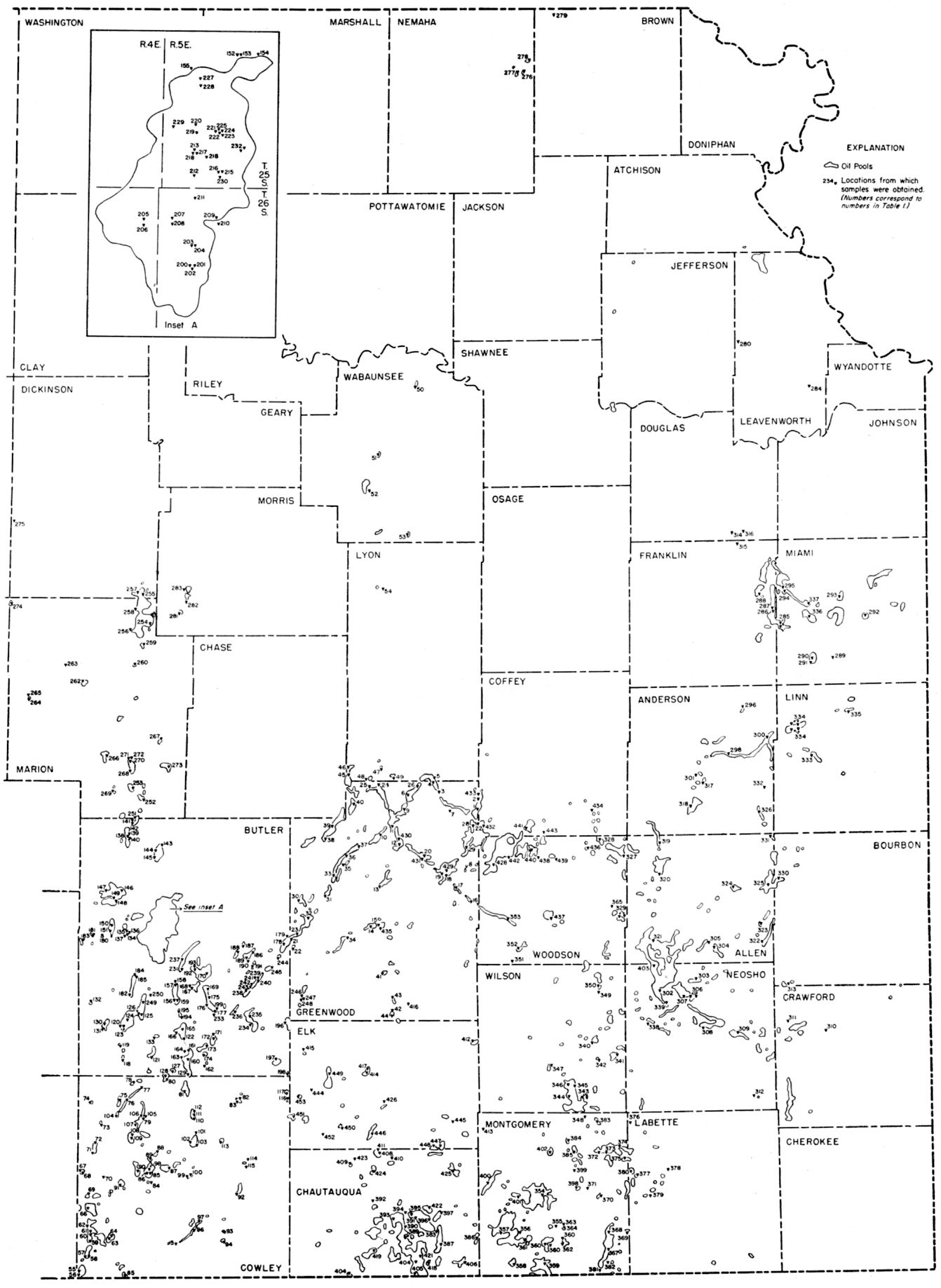
Table 1--Physical properties of eastern Kansas crude oils.
| Sample no. |
Location | Depth, feet |
Formation | Gravity, A.P.I. Corrected @ 60°F |
Viscosity, centipoises | Interfacial tension, dynes/cm @ 60°F |
||
|---|---|---|---|---|---|---|---|---|
| 70°F. | 100°F. | 120°F. | ||||||
| 1 | SE 27-22-13E | 1,900 | "Mississippi lime" | 39.2 | 4.976 | 3.349 | 2.612 | 29.14 |
| 2 | SE 15-22-13E | 1,850 | "Burgess" | 37.7 | 5.243 | 3.412 | 2.640 | 23.29 |
| 3 | SW 10-22-12E | 1,824 | "Bartlesville" | 40.1 | 4.715 | 3.182 | 2.317 | 26.08 |
| 4 | NW 4-22-12E | 1,870 | "Bartlesville" | 38.3 | 5.766 | 3.749 | 2.881 | 17.90 |
| 5 | 33-21-12E | 1,800 | "Bartlesville" | 38.0 | 4.647 | 3.160 | 2.446 | 25.80 |
| 6 | NW 14-22-11E | 1,926 | "Bartlesville" | 38.4 | 4.014 | 2.757 | 2.176 | 26.44 |
| 7 | NW 25-22-12E | 1,750 | "Bartlesville" | 40.0 | 4.048 | 2.823 | 2.249 | 27.30 |
| 8 | NE 17-24-13E | 1,614 | "Mississippi lime" | 37.4 | 4.934 | 3.371 | 2.638 | 30.02 |
| 9 | 27-22-11E | 1,965 | "Bartlesville" | 41.4 | 3.964 | 2.804 | 2.259 | 30.53 |
| 10 | SE 13-23-10E | 2,500 | "Bartlesville" | 40.4 | 4.541 | 3.050 | 2.463 | 30.31 |
| 11 | 8-23-11E | "Bartlesville" | 41.1 | 5.465 | 2.658 | 2.141 | 26.89 | |
| 12 | NE 28-23-11E | 1,930 | "Bartlesville" | 41.5 | 4.909 | 3.240 | 2.512 | 23.94 |
| 13 | NE 36-24-10E | 1,900 | "Bartlesville" | 39.4 | 4.884 | 3.116 | 2.496 | 26.72 |
| 14 | SW 35-25-10E | 1,980 | "Mississippi lime" | 34.8 | 7.014 | 4.527 | 3.545 | 27.59 |
| 15 | 36-25-10E | 2,000 | "Mississippi lime" | 34.3 | 7.008 | 4.468 | 3.517 | 29.13 |
| 16 | 9-25-13E | 1,520 | "Bartlesville" | 35.0 | 7.069 | 4.523 | 3.541 | 26.33 |
| 17 | NW 31-24-13E | 1,786 | "Mississippi lime" | 36.6 | 6.079 | 4.069 | 3.158 | 31.84 |
| 18 | 23-24-12E | 1,727 | "Mississippi lime" | 38.7 | 4.391 | 3.061 | 2.466 | 29.12 |
| 19 | NE 22-24-12E | 1,650 | "Bartlesville" | 41.8 | 3.789 | 2.706 | 2.151 | 34.25 |
| 20 | NE 6-24-12E | 1,800 | "Bartlesville" | 41.4 | 3.729 | 2.641 | 2.125 | 34.40 |
| 21 | SW 10-26-8E | 2,501 | "Bartlesville" | 38.5 | 5.362 | 3.541 | 2.860 | 30.03 |
| 22 | 22-26-8E | 2,500 | "Mississippi lime" | 30.9 | 17.31 | 9.694 | 6.620 | 34.33 |
| 23 | SW 2-26-8E | 2,403 | "Bartlesville" | 37.2 | 6.241 | 3.986 | 2.994 | 30.86 |
| 24 | SW 1-22-10E | 2,300 | "Bartlesville" | 39.3 | 6.227 | 3.257 | 2.447 | 29.81 |
| 25 | SE 3-22-10E | 2,340 | "Bartlesville" | 41.3 | 3.580 | 2.515 | 2.061 | 30.55 |
| 26 | SE 1-22-11E | 1,830 | "Bartlesville" | 39.6 | 4.339 | 2.953 | 2.395 | 31.59 |
| 27 | SE 3-23-13E | 1,835 | "Mississippi lime" | 39.6 | 4.265 | 2.933 | 2.396 | 31.70 |
| 28 | NE 9-23-13E | 1,630 | "Bartlesville" | 37.3 | 6.137 | 4.027 | 3.194 | 34.23 |
| 29 | SE 29-23-13E | 1,735 | "Mississippi lime" | 39.7 | 4.313 | 3.035 | 2.516 | 33.17 |
| 30 | NE 11-25-8E | 2,352 | "Bartlesville" | 39.6 | 4.284 | 2.953 | 2.409 | 34.80 |
| 31 | SE 4-25-9E | 2,375 | "Bartlesville" | 40.7 | 3.989 | 2.773 | 2.282 | 35.59 |
| 32 | NW 30-25-9E | 2,450 | "Bartlesville" | 40.3 | 4.289 | 2.993 | 2.506 | 35.13 |
| 33 | NW 23-24-9E | 2,200 | "Bartlesville" | 41.0 | 3.951 | 2.731 | 2.251 | 30.88 |
| 34 | N2 7-26-10E | 2,100 | "Mississippi lime" | 33.6 | 8.892 | 5.552 | 4.241 | 31.40 |
| 35 | SE 12-24-9E | 2,250 | "Bartlesville" | 39.2 | 4.852 | 3.326 | 2.663 | 32.67 |
| 36 | NW 6-24-10E | 2,300 | "Bartlesville" | 40.2 | 4.160 | 2.914 | 2.378 | 11.50 |
| 37 | SW 28-23-10E | 2,350 | "Bartlesville" | 40.5 | 3.996 | 2.802 | 2.275 | 29.38 |
| 38 | NE 21-23-9E | 2,600 | "Bartlesville" | 42.1 | 3.534 | 2.479 | 2.025 | 28.47 |
| 39 | NE 10-23-9E | 2,350 | "Bartlesville" | 41.5 | 4.904 | 2.856 | 2.199 | 33.46 |
| 40 | SW 20-22-10E | 2,350 | "Bartlesville" | 40.9 | 3.781 | 2.653 | 2.179 | 30.35 |
| 41 | NW 7-27-11E | 1,910 | "Mississippi lime" | 30.3 | 19.259 | 10.720 | 7.776 | 36.27 |
| 42 | NE 8-28-11E | 785 | Topeka | 30.8 | 21.859 | 11.074 | 8.380 | 32.94 |
| 43 | NE 32-27-11E | 1,949 | "Mississippi lime" | 26.6 | 56.810 | 24.520 | 16.090 | 34.36 |
| 44 | NE 17-28-11E | 1,227 | Kansas City | 35.7 | 7.423 | 4.677 | 3.690 | 30.93 |
| 45 | SW 30-21-10E | 2,200 | "Bartlesville" | 40.7 | 3.986 | 2.785 | 2.244 | 30.74 |
| 46 | SW 19-21-10E | 2,200 | "Bartlesville" | 38.9 | 4.964 | 3.360 | 2.695 | 30.35 |
| 47 | SE 24-21-10E | 2,600 | Viola | 23.9 | 131.000 | 58.000 | 33.000 | 28.69 |
| 48 | SW 34-21-10E | 2,100 | Miss. "chat" | 34.3 | 9.853 | 6.102 | 4.579 | 24.16 |
| 49 | SE 32-21-11E | 1,970 | "Bartlesville" | 37.1 | 6.129 | 3.982 | 3.132 | 24.48 |
| 50 | NE 11-11-11E | 2,904 | Viola | 23.8 | 230.000 | 85.000 | 48.000 | 39.59 |
| 51 | NE 2-13-10E | 2,935 | Viola | 24.4 | 132.000 | 71.000 | 50.000 | 40.00 |
| 52 | NW 3-14-10E | Viola | 26.8 | 70.000 | 35.000 | 24.000 | 37.80 | |
| 53 | 10-15-11E | 3,230 | Simpson | 21.6 | 1905.000 | 685.000 | 392.000 | 38.43 |
| 54 | NE 25-16-10E | 2,950 | "Hunton" | 28.3 | 81.000 | 44.000 | 34.000 | 33.28 |
| 55 | SW 7-35-3E | 3,475 | "Bartlesville" | 39.5 | 3.883 | 2.677 | 2.190 | 27.02 |
| 56 | NW 18-35-3E | 3,760 | Simpson | 41.6 | 3.030 | 2.158 | 1.767 | 29.73 |
| 57 | NW 32-34-3E | 3,421 | "Mississippi lime" | 33.9 | 13.393 | 7.796 | 5.795 | 34.16 |
| 58 | NW 32-34-3E | 3,398 | "Bartlesville" | 35.1 | 13.740 | 7.937 | 5.865 | 34.36 |
| 59 | SE 17-34-3E | 3,360 | "Bartlesville" | 38.8 | 11.370 | 6.785 | 5.023 | 32.97 |
| 60 | SE 8-34-3E | 2,588 | "Layton" | 37.3 | 6.220 | 4.047 | 3.216 | 25.38 |
| 61 | SE 8-34-3E | 3,314 | "Bartlesville" | 37.1 | 5.867 | 3.874 | 3.033 | 31.10 |
| 62 | NW 5-34-3E | 3,334 | "Chat" | 40.6 | 4.264 | 2.895 | 2.330 | 25.84 |
| 63 | NW 13-34-3E | 3,371 | "Burgess" | 39.1 | 5.598 | 3.661 | 2.927 | 32.98 |
| 64 | NW 13-34-3E | 2,842 | Kansas City | 38.4 | 5.366 | 3.554 | 2.812 | 33.81 |
| 65 | SE 17-35-4E | 3,248 | "Bartlesville" | 40.2 | 4.574 | 3.057 | 2.451 | 29.43 |
| 66 | SE 20-33-3E | 3,200 | "Bartlesville" | 41.4 | 3.460 | 2.459 | 2.031 | 31.44 |
| 67 | NW 19-32-3E | 3,501 | Arbuckle | 36.5 | 5.990 | 3.909 | 3.105 | 33.93 |
| 68 | SE 19-32-3E | 2,760 | "Bartlesville" | 38.0 | 4.228 | 2.872 | 2.317 | 26.16 |
| 69 | NE 8-33-3E | 3,500 | Arbuckle | 40.8 | 2.976 | 2.117 | 1.741 | 29.26 |
| 70 | NW 26-32-3E | 2,690 | Kansas City | 39.7 | 4.080 | 2.802 | 2.265 | 32.40 |
| 71 | NW 4-32-3E | 3,200 | Arbuckle | 37.4 | 4.941 | 3.288 | 2.627 | 28.22 |
| 72 | SE 28-31-3E | 2,090 | "Stalnaker" | 38.4 | 4.868 | 3.247 | 2.582 | 32.61 |
| 73 | SE 10-31-3E | 3,100 | Arbuckle | 36.8 | 5.507 | 3.657 | 2.907 | 36.34 |
| 74 | NE 29-30-3E | 1,808 | "Hoover" | 36.3 | 6.288 | 4.080 | 3.183 | 35.96 |
| 75 | SE 19-30-4E | 2,850 | "Bartlesville" | 37.8 | 4.512 | 3.089 | 2.480 | 35.74 |
| 76 | SE 20-30-4E | 2,825 | "Bartlesville" | 39.4 | 3.596 | 2.549 | 2.069 | 36.58 |
| 77 | SW 11-30-4E | 2,800 | "Bartlesville" | 38.0 | 4.258 | 2.940 | 2.381 | 31.83 |
| 78 | NE 9-30-4E | 3,306 | Arbuckle | 25.9 | 26.870 | 13.540 | 9.322 | 28.62 |
| 79 | SE 2-31-4E | 2,950 | "Bartlesville" | 39.8 | 3.927 | 2.711 | 2.197 | 35.53 |
| 80 | NW 4-30-5E | 2,600 | "Bartlesville" | 41.2 | 3.702 | 2.581 | 2.104 | 35.40 |
| 81 | NW 13-30-5E | 2,835 | "Bartlesville" | 40.4 | 4.490 | 3.047 | 2.471 | 34.43 |
| 82 | SW 21-30-7E | 2,840 | "Mississippi lime" | 39.9 | 3.976 | 2.731 | 2.230 | 33.80 |
| 83 | NE 29-30-7E | 2,890 | "Chat" | 40.1 | 4.060 | 2.783 | 2.264 | 31.84 |
| 84 | NE 36-32-4E | 1,800 | "Hoover" | 38.2 | 5.318 | 3.548 | 2.850 | 31.14 |
| 85 | SE 24-32-4E | 1,742 | "U. Hoover" | 40.8 | 3.926 | 2.746 | 2.230 | 34.96 |
| 86 | SW 24-32-4E | 3,000 | "Bartlesville" | 40.3 | 4.010 | 2.781 | 2.247 | 33.43 |
| 87 | SE 16-32-5E | 3,090 | "Bartlesville" | 43.0 | 3.050 | 2.173 | 1.839 | 33.61 |
| 88 | NE 6-32-5E | 2,300 | "Layton" | 40.2 | 4.366 | 2.980 | 2.415 | 33.32 |
| 89 | NE 12-32-4E | 2,570 | Kansas City | 36.7 | 7.095 | 4.557 | 3.626 | 34.66 |
| 90 | NE 22-32-4E | 2,300 | "Layton" | 39.4 | 5.225 | 3.465 | 2.801 | 36.18 |
| 91 | SE 31-32-4E | 3,140 | "Bartlesville" | 41.5 | 3.481 | 2.419 | 1.999 | 30.88 |
| 92 | NE 8-33-7E | 2,655 | Mississippian | 36.0 | 8.006 | 4.941 | 3.879 | 33.15 |
| 93 | NE 12-34-6E | 3,100 | "Mississippi lime" | 37.6 | 6.350 | 4.092 | 3.220 | 33.76 |
| 94 | SE 13-34-6E | 39.5 | 4.984 | 3.325 | 2.672 | 33.30 | ||
| 95 | NE 22-34-5E | 2,980 | "Bartlesville" | 37.1 | 8.007 | 5.005 | 3.852 | 33.59 |
| 96 | SE 6-34-6E | 2,945 | "Bartlesville" | 36.7 | 9.530 | 5.904 | 4.483 | 33.29 |
| 97 | SE 32-33-6E | 2,950 | "Bartlesville" | 37.0 | 9.218 | 5.669 | 4.442 | 32.45 |
| 98 | SE 24-32-4E | 1,458 | "L. Peacock" | 40.2 | 4.494 | 2.978 | 2.411 | 32.09 |
| 99 | NE 25-32-5E | 3,000 | "Mississippi lime" | 37.5 | 6.858 | 4.439 | 3.486 | 35.05 |
| 100 | NW 30-32-6E | 2,232 | "Layton" | 38.1 | 5.449 | 3.622 | 2.850 | 36.84 |
| 101 | NW 20-31-6E | 2,970 | "Bartlesville" | 38.6 | 5.381 | 3.577 | 2.842 | 33.98 |
| 102 | SW 30-31-6E | 2,990 | "Bartlesville" | 40.1 | 4.449 | 3.016 | 2.426 | 29.06 |
| 103 | NW 32-31-6E | 2,300 | "Peru" | 40.0 | 4.850 | 3.349 | 2.636 | 33.14 |
| 104 | NW 6-31-4E | 2,840 | "Bartlesville" | 37.6 | 4.488 | 3.051 | 2.439 | 30.66 |
| 105 | SE 2-31-4E | 3,000 | "Bartlesville" | 38.5 | 4.006 | 2.799 | 2.273 | 32.27 |
| 106 | NW 2-31-4E | 3,000 | "Bartlesville" | 39.8 | 4.099 | 2.814 | 2.269 | 33.36 |
| 107 | SW 10-31-4E | 3,000 | "Bartlesville" | 40.5 | 3.853 | 2.666 | 1.416 | 31.84 |
| 108 | SE 21-31-4E | 3,350 | Arbuckle | 37.8 | 4.464 | 2.992 | 2.402 | 28.93 |
| 109 | SE 21-31-4E | 2,300 | "Peru" | 39.3 | 5.297 | 3.525 | 2.793 | 32.12 |
| 110 | SE 6-31-6E | (2,821) 2,849 |
"Bartlesville" | 37.7 | 6.541 | 4.179 | 3.296 | 31.67 |
| 111 | NE 6-31-6E | (2,846) 2,883 |
"Bartlesville" | 34.9 | 9.180 | 5.668 | 4.329 | 34.11 |
| 112 | SE 31-30-6E | (2,840) 2,894 |
"Bartlesville" | 39.0 | 4.927 | 3.324 | 2.653 | 31.40 |
| 113 | NE 25-31-6E | 2,170 | "Layton" | 33.7 | 12.430 | 6.815 | 5.105 | 33.92 |
| 114 | NE 10-32-7E | 2,127 | "Layton" | 35.7 | 7.574 | 4.757 | 3.709 | 34.10 |
| 115 | SW 15-32-7E | 2,850 | "Bartlesville" | 35.6 | 5.287 | 3.482 | 2.787 | 33.30 |
| 116 | SW 21-30-8E | 2,220 | Kansas City | 35.2 | 8.364 | 5.163 | 3.828 | 35.34 |
| 117 | SW 16-30-8E | 2,225 | Kansas City | 35.6 | 8.516 | 5.263 | 3.858 | 35.65 |
| 118 | NW 20-29-4E | 1,900 | Lansing | 39.1 | 4.738 | 3.082 | 2.499 | 30.14 |
| 119 | SE 6-29-4E | 2,530 | Arbuckle | 30.0 | 20.970 | 11.252 | 7.959 | 32.17 |
| 120 | SE 19-28-4E | 2,496 | Arbuckle | 32.4 | 8.450 | 5.166 | 3.842 | 31.42 |
| 121 | SE 13-29-4E | 2,790 | "Bartlesville" | 37.3 | 5.339 | 3.538 | 2.824 | 33.43 |
| 122 | SW 36-28-5E | 2,796 | "Bartlesville" | 41.4 | 3.634 | 2.533 | 2.069 | 30.50 |
| 123 | SW 20-28-4E | 1,700 | Lansing | 33.6 | 10.095 | 6.082 | 4.507 | 33.13 |
| 124 | SE 17-28-4E | 2,450 | Arbuckle | 33.3 | 7.886 | 4.783 | 3.781 | 32.59 |
| 125 | SW 11-28-4E | 2,600 | Simpson | 32.7 | 8.545 | 5.253 | 3.252 | 31.61 |
| 126 | SE 10-28-4E | 2,000 | Kansas City | 33.3 | 8.138 | 5.072 | 3.900 | 32.17 |
| 127 | NW 34-29-5E | 2,810 | "Bartlesville" | 38.1 | 5.521 | 3.547 | 2.817 | 31.07 |
| 128 | SW 33-29-5E | 2,800 | "Bartlesville" | 39.3 | 4.410 | 2.992 | 2.396 | 33.67 |
| 129 | SE 36-29-5E | 2,800 | "Bartlesville" | 40.9 | 3.878 | 2.701 | 2.256 | 29.66 |
| 130 | NW 23-28-3E | 3,000 | Simpson | 32.6 | 10.663 | 6.372 | 4.801 | 34.01 |
| 131 | NE 27-28-3E | 3,025 | Simpson | 31.0 | 13.258 | 7.751 | 5.906 | 33.06 |
| 132 | SE 32-27-3E | 3,100 | Simpson | 33.5 | 10.702 | 5.829 | 4.295 | 35.76 |
| 133 | SW 31-28-5E | 2,794 | "U. Bartlesville" | 36.4 | 7.116 | 4.541 | 3.492 | 35.55 |
| 134 | SE 5-26-4E | 2,200 | Kansas City | 32.8 | 14.386 | 8.042 | 5.834 | 34.33 |
| 135 | SE 5-26-4E | 2,250 | Viola | 39.2 | 3.764 | 2.627 | 2.134 | 31.86 |
| 136 | SE 5-26-4E | 2,450 | Simpson | 39.0 | 3.740 | 2.646 | 2.139 | 32.90 |
| 137 | SE 5-26-4E | 2,270 | Mississippian | 43.3 | 2.687 | 1.945 | 1.637 | 31.69 |
| 138 | SE 17-23-4E | 2,410 | Viola | 35.1 | 6.647 | 4.245 | 3.361 | 32.58 |
| 139 | SE 17-23-4E | 2,175 | Kansas City | 34.2 | 14.079 | 7.772 | 5.755 | 33.18 |
| 140 | SE 17-23-4E | 2,350 | "Hunton" | 33.9 | 7.408 | 4.687 | 3.613 | 31.92 |
| 141 | NW 4-23-4E | 2,100 | Kansas City | 29.9 | 25.328 | 12.650 | 9.060 | 32.45 |
| 142 | NW 4-23-4E | 2,400 | "Hunton" | 35.7 | 5.227 | 3.485 | 2.768 | 29.62 |
| 143 | NW 29-23-5E: | 2,475 | Miss. "chat" | 40.7 | 3.272 | 2.317 | 1.895 | 33.14 |
| 144 | NW 31-23-5E | 2,475 | Miss. "chat" | 41.4 | 3.210 | 2.280 | 1.863 | 34.71 |
| 145 | NW 6-24-5E | 2,475 | Miss. "chat" | 42.0 | 2.921 | 2.104 | 1.749 | 31.48 |
| 146 | SE 31-24-4E | 2,710 | "Potwin chat" | 44.0 | 2.464 | 1.804 | 1.510 | 31.76 |
| 147 | SW 35-24-3E | 2,725 | "Mississippi lime" | 42.0 | 2.849 | 2.043 | 1.676 | 32.50 |
| 148 | NE 12-25-3E | 2,700 | "Mississippi lime" | 42.2 | 2.836 | 2.099 | 1.714 | 31.24 |
| 149 | SW 1-25-3E | 2,700 | "Mississippi lime" | 43.3 | 2.790 | 2.030 | 1.675 | 33.83 |
| 150 | NW 36-25-3E | 2,713 | Miss. "chat" | 44.0 | 2.666 | 1.945 | 1.605 | 31.76 |
| 151 | NW 1-26-3E | 2,690 | Miss. "chat" | 43.4 | 2.901 | 2.086 | 1.716 | 26.40 |
| 152 | NW 3-25-5E | 2,544 | Arbuckle | 31.2 | 12.911 | 7.471 | 5.523 | 33.55 |
| 153 | NW 3-25-5E | 2,445 | Viola | 34.7 | 6.776 | 4.305 | 3.327 | 29.06 |
| 154 | NW 2-25-5E | 2,238 | "Peru" | 38.6 | 4.567 | 3.138 | 2.438 | 32.16 |
| 155 | SW 5-25-5E | 722 | Admire | 34.9 | 6.825 | 4.345 | 3.404 | 28.58 |
| 156 | SE 34-27-5E | 3,125 | Arbuckle | 33.3 | 10.283 | 6.226 | 4.723 | 31.39 |
| 157 | NE 22-27-5E | 2,771 | "Bartlesville" | 32.9 | 15.121 | 6.788 | 4.913 | 27.53 |
| 158 | SE 15-27-5E | 2,776 | "Bartlesville" | 40.4 | 4.505 | 3.082 | 2.465 | 33.78 |
| 159 | SW 35-27-5E | 2,770 | "Bartlesville" | 39.8 | 4.686 | 3.172 | 2.530 | 31.46 |
| 160 | NE 24-29-5E | 2,800 | "Bartlesville" | 39.6 | 4.731 | 3.129 | 2.496 | 32.39 |
| 161 | SW 7-29-6E | 2,835 | "Mississippi lime" | 39.0 | 5.122 | 3.385 | 2.696 | 33.48 |
| 162 | NE 28-29-6E | 2,803 | "Mississippi lime" | 35.3 | 9.284 | 5.569 | 4.224 | 35.36 |
| 163 | SE 14-29-5E | 2,800 | "Bartlesville" | 35.5 | 8.645 | 5.502 | 4.213 | 36.74 |
| 164 | SW 12-29-5E | 2,800 | "Bartlesville" | 37.8 | 5.631 | 3.635 | 2.868 | 30.76 |
| 165 | NE 26-28-5E | 2,800 | "Bartlesville" | 41.7 | 4.941 | 3.290 | 2.595 | 28.49 |
| 166 | SE 27-28-5E | 2,800 | "Bartlesville" | 41.9 | 5.032 | 3.348 | 2.657 | 30.70 |
| 167 | SW 19-27-6E | 2,150 | Kansas City | 34.3 | 11.098 | 6.465 | 4.850 | 33.03 |
| 168 | SW 19-27-6E | 2,750 | "Bartlesville" | 38.7 | 6.437 | 4.169 | 3.227 | 29.65 |
| 169 | SW 22-27-6E | 3,050 | Viola | 35.4 | 5.892 | 3.806 | 2.986 | 32.42 |
| 170 | NE 9-27-6E | 3,150 | Viola | 34.3 | 6.804 | 4.355 | 3.388 | 31.40 |
| 171 | NE 34-28-6E | 2,138 | Kansas City | 35.3 | 9.003 | 5.591 | 4.332 | 33.94 |
| 172 | SE 34-28-6E | 2,825 | Mississippian | 40.0 | 4.367 | 2.972 | 2.396 | 31.90 |
| 173 | SE 4-29-6E | 2,800 | "Bartlesville" | 40.7 | 3.859 | 2.693 | 2.170 | 33.86 |
| 174 | NW 16-29-6E | 2,500 | "Peru" | 35.3 | 12.513 | 7.079 | 5.331 | 36.77 |
| 175 | NW 34-27-6E | 3,075 | Viola | 34.8 | 6.036 | 3.886 | 3.066 | 30.53 |
| 176 | NE 4-28-6E | 3,083 | Viola | 35.8 | 5.538 | 3.633 | 2.891 | 31.56 |
| 177 | NW 11-28-6E | 3,037 | Simpson | 36.3 | 5.641 | 3.661 | 2.909 | 31.26 |
| 178 | NW 16-26-8E | 2,525 | "Bartlesville" | 37.8 | 6.323 | 4.139 | 3.272 | 36.17 |
| 179 | NE 9-26-8E | 2,480 | "Cattleman" | 39.6 | 4.904 | 3.282 | 2.665 | 32.39 |
| 180 | SE 3-26-3E | 2,706 | Miss. "chat" | 42.9 | 2.578 | 1.873 | 1.573 | 31.61 |
| 181 | SW 4-23-3E | 2,771 | Miss. "chat" | 44.5 | 2.855 | 2.047 | 1.686 | 30.16 |
| 182 | SW 28-27-4E | 2,000 | Kansas City | 36.1 | 6.731 | 4.297 | 3.319 | 29.46 |
| 183 | SE 7-26-3E | 2,866 | Miss. "chat" | 43.0 | 3.054 | 2.161 | 1.786 | 32.29 |
| 184 | SW 10-27-4E | 2,035 | Kansas City | 32.8 | 14.184 | 8.063 | 5.978 | 34.94 |
| 185 | SW 10-27-4E | 2,455 | Arbuckle | 40.1 | 4.176 | 2.842 | 2.308 | 31.21 |
| 186 | SW 23-26-7E | 2,800 | "Mississippi lime" | 32.6 | 10.314 | 6.111 | 4.664 | 33.66 |
| 187 | SE 16-26-7E | 2,781 | "Mississippi lime" | 33.8 | 9.191 | 5.630 | 4.282 | 35.36 |
| 188 | SE 20-26-7E | 2,208 | Kansas City | 35.8 | 7.471 | 4.667 | 3.659 | 33.18 |
| 189 | SW 27-26-7E | 2,700 | "Mississippi lime" | 33.1 | 10.385 | 6.245 | 4.687 | 33.94 |
| 190 | SW 27-23-7E | 2,175 | Kansas City | 33.5 | 10.227 | 6.117 | 4.635 | 34.94 |
| 191 | NW 2-27-7E | 2,655 | "Bartlesville" | 41.4 | 3.821 | 2.658 | 2.175 | 34.03 |
| 192 | SE 6-27-6E | 3,100 | Viola | 34.2 | 9.511 | 5.719 | 4.296 | 29.58 |
| 193 | NE 6-27-6E | 2,750 | "Bartlesville" | 34.7 | 9.062 | 5.632 | 4.264 | 33.22 |
| 194 | NE 14-28-5E | 2,700 | "Bartlesville" | 39.0 | 5.061 | 3.261 | 2.609 | 31.77 |
| 195 | NW 11-28-5E | 2,700 | "Bartlesville" | 38.6 | 4.982 | 3.309 | 2.659 | 31.25 |
| 196 | NW 21-28-8E | 2,725 | "Mississippi lime" | 37.2 | 4.714 | 3.163 | 2.530 | 28.45 |
| 197 | NE 19-29-8E | 2,784 | "Mississippi lime" | 40.0 | 3.514 | 2.459 | 2.021 | 30.54 |
| 198 | SE 33-29-8E | 2,250 | Kansas City | 37.9 | 5.456 | 3.619 | 2.857 | 25.48 |
| 199 | NW 11-28-6E | 2,750 | "Mississippi lime" | 34.7 | 7.868 | 4.905 | 3.714 | 32.76 |
| 200 | 20-26-5E | 2,533 | Arbuckle | 33.8 | 7.830 | 4.951 | 3.763 | 34.77 |
| 201 | 20-26-5E | 2,548 | Simpson | 33.5 | 7.729 | 4.932 | 3.747 | 28.72 |
| 202 | 20-26-5E | 2,620 | Viola | 34.3 | 7.568 | 4.800 | 3.668 | 33.27 |
| 203 | 17-26-5E | 2,455 | Arbuckle | 35.1 | 6.858 | 4.416 | 3.383 | 32.70 |
| 204 | 17-26-5E | 1,694 | Lansing | 35.1 | 6.835 | 4.411 | 3.377 | 33.51 |
| 205 | 12-26-4E | 2,400 | Arbuckle | 33.9 | 7.830 | 4.993 | 3.780 | 32.06 |
| 206 | 12-26-4E | 1,703 | Lansing | 35.8 | 6.722 | 4.319 | 3.321 | 33.54 |
| 207 | 7-26-5E | 2,432 | Arbuckle | 34.9 | 6.995 | 4.499 | 3.492 | 30.64 |
| 208 | 7-26-5E | 1,711 | Lansing | 36.6 | 5.614 | 3.823 | 3.021 | 33.09 |
| 209 | 9-26-5E | 2,427 | Arbuckle | 34.3 | 7.289 | 4.760 | 3.655 | 32.14 |
| 210 | 9-26-5E | 2,580 | Simpson | 37.1 | 5.096 | 3.508 | 2.756 | 32.56 |
| 211 | 5-26-5E | 2,455 | Arbuckle | 34.3 | 7.129 | 4.718 | 3.640 | 30.95 |
| 212 | 32-25-5E | 636 | Admire | 36.5 | 5.804 | 3.955 | 3.127 | 28.74 |
| 213 | 29-25-5E | 2,450 | Simpson | 38.0 | 4.484 | 3.139 | 2.487 | 32.12 |
| 215 | 33-25-5E | 2,437 | Arbuckle | 36.8 | 6.707 | 4.330 | 3.371 | 23.61 |
| 216 | 33-25-5E | 632 | Admire | 37.6 | 5.318 | 3.546 | 2.782 | 29.80 |
| 217 | 29-25-5E | 638 | Admire | 37.5 | 5.476 | 3.605 | 2.774 | 26.18 |
| 218 | 29-25-5E | 2,493 | Arbuckle | 36.7 | 5.544 | 3.659 | 2.901 | 23.92 |
| 219 | 20-25-5E | 578 | Admire | 36.5 | 6.507 | 4.185 | 3.298 | 31.37 |
| 220 | 20-25-5E | 703 | Admire | 37.2 | 5.609 | 3.707 | 2.945 | 33.94 |
| 221 | 21-25-5E | 2,407 | Arbuckle | 34.9 | 6.969 | 4.483 | 3.469 | 12.64 |
| 222 | 21-25-5E | 552 | Admire | 36.3 | 6.998 | 4.489 | 3.464 | 26.51 |
| 223 | 21-25-5E | 665 | Admire | 35.6 | 7.072 | 4.483 | 3.348 | 33.24 |
| 224 | 21-25-5E | 1,537 | Douglas | 37.0 | 5.791 | 3.807 | 2.992 | 27.34 |
| 225 | 21-25-5E | 1,480 | Douglas | 37.1 | 5.538 | 3.643 | 2.886 | 25.94 |
| 227 | 8-25-5E | 2,458 | Viola | 37.4 | 4.942 | 3.301 | 2.640 | 33.34 |
| 228 | 8-25-5E | 2,449 | Arbuckle | 38.3 | 4.421 | 2.996 | 2.428 | 28.91 |
| 229 | 19-25-5E | 2,561 | "Mississippi lime" | 44.5 | 2.441 | 1.757 | 1.467 | 27.65 |
| 230 | 33-25-5E | 2,002 | Kansas City | 33.6 | 9.721 | 5.891 | 4.511 | 30.13 |
| 231 | 2-27-5E | 2,700 | "Bartlesville" | 37.6 | 5.908 | 3.847 | 3.036 | 32.51 |
| 232 | 27-25-5E | 2,250 | Marmaton | 37.8 | 4.842 | 3.223 | 2.575 | 31.57 |
| 233 | NW 11-28-6E | Arbuckle | 36.0 | 5.664 | 3.695 | 2.891 | 29.04 | |
| 234 | SE 22-28-7E | 2,350 | "Peru" | 35.9 | 10.092 | 6.126 | 4.688 | 33.08 |
| 235 | NE 15-28-7E | 2,700 | "Mississippi lime" | 36.1 | 7.175 | 4.545 | 3.539 | 32.70 |
| 236 | NW 8-28-7E | 2,700 | "Bartlesville" | 38.2 | 5.670 | 3.559 | 2.775 | 26.80 |
| 237 | SE 26-26-5E | 2,756 | "Bartlesville" | 38.4 | 5.680 | 3.763 | 2.978 | 33.00 |
| 238 | NW 27-27-7E | 2,750 | "Bartlesville" | 40.9 | 4.645 | 2.911 | 2.340 | 32.04 |
| 239 | NW 13-27-7E | 2,690 | "Cattleman" | 36.4 | 7.514 | 4.754 | 3.748 | 32.78 |
| 240 | NW 13-27-7E | 2,100 | Kansas City | 37.4 | 5.103 | 3.385 | 2.693 | 30.92 |
| 241 | NE 14-27-7E | 2,725 | "Bartlesville" | 39.9 | 4.500 | 3.055 | 2.465 | 26.11 |
| 242 | NW 23-27-7E | 3,100 | Arbuckle | 30.8 | 16.868 | 9.230 | 6.654 | 29.23 |
| 243 | NW 23-27-7E | 2,750 | "Bartlesville" | 41.9 | 3.866 | 2.673 | 2.166 | 30.72 |
| 244 | SW 29-26-8E | 2,750 | "Bartlesville" | 36.6 | 8.106 | 5.142 | 3.976 | 33.09 |
| 245 | Lot 27 6-27-8E | 2,750 | "Bartlesville" | 37.2 | 5.884 | 3.838 | 2.996 | 32.43 |
| 246 | NW 36-27-8E | 2,700 | Arbuckle | 30.7 | 23.665 | 12.258 | 8.552 | 33.75 |
| 247 | NW 36-27-8E | 2,450 | Mississippian | 37.8 | 4.879 | 3.266 | 2.639 | 29.64 |
| 248 | NW 36-27-8E | 1,825 | "Peru" | 35.7 | 6.368 | 4.109 | 3.213 | 32.28 |
| 249 | SE 35-27-4E | 2,050 | Kansas City | 37.3 | 6.003 | 3.927 | 3.102 | 30.14 |
| 250 | SE 25-27-4E | 2,565 | Arbuckle | 32.7 | 8.264 | 5.090 | 3.908 | 27.69 |
| 251 | SE 33-22-4E | 2,125 | Kansas City | 32.9 | 18.109 | 9.763 | 7.083 | 33.37 |
| 252 | SW 14-22-4E | 2,545 | Viola | 33.5 | 9.333 | 5.850 | 4.259 | 31.06 |
| 253 | SW 4-22-4E | 2,460 | "Hunton" | 33.9 | 8.563 | 5.313 | 4.042 | 29.28 |
| 254 | NE 26-17-4E | 2,350 | "Mississippi lime" | 36.5 | 8.994 | 5.756 | 4.460 | 34.28 |
| 255 | NE 34-16-4E | 2,350 | Miss. "chat" | 35.7 | 11.269 | 7.134 | 5.495 | 34.85 |
| 256 | NE 32-17-4E | 2,400 | Miss. "chat" | 36.5 | 8.700 | 5.558 | 4.336 | 31.95 |
| 257 | NE 33-16-4E | 2,350 | Miss. "chat" | 31.6 | 20.044 | 11.324 | 8.180 | 32.52 |
| 258 | SW 9-17-4E | 2,350 | Miss. "chat" | 35.5 | 10.632 | 6.587 | 5.016 | 35.55 |
| 259 | NW 10-18-4E | 2,375 | Miss. "chat" | 36.8 | 8.416 | 5.385 | 4.182 | 32.02 |
| 260 | SW 28-18-4E | 2,375 | Miss. "chat" | 41.7 | 4.432 | 3.078 | 2.534 | 31.17 |
| 261 | SE 6-19-4E | 2,375 | Miss. "chat" | 31.9 | 13.182 | 7.791 | 5.904 | 33.67 |
| 262 | SE 12-19-2E | 2,850 | Viola | 32.5 | 30.398 | 16.033 | 11.419 | 35.60 |
| 263 | NW 34-18-2E | Viola | 31.5 | 34.918 | 18.506 | 12.765 | 37.35 | |
| 264 | SW 27-19-1E | 2,830 | Viola | 18.7 | 235.000 | 82.000 | 50.000 | 46.58 |
| 265 | SW 27-19-1E | 2,930 | Simpson | 29.7 | 68.000 | 30.000 | 26.000 | 35.78 |
| 266 | SW 11-21-3E | 2,800 | "Hunton" | 38.1 | 44.922 | 17.197 | 11.423 | 26.27 |
| 267 | NE 31-20-5E | 2,550 | Misener | 37.5 | 4.990 | 3.366 | 2.697 | 29.78 |
| 268 | NE 29-21-4E | 2,400 | Viola | 33.0 | 10.458 | 6.270 | 4.696 | 31.96 |
| 269 | NW 12-22-3E | 2,474 | "Mississippi lime" | 36.3 | 7.553 | 4.676 | 3.644 | 30.83 |
| 270 | SE 17-21-4E | 2,050 | Kansas City | 32.5 | 21.882 | 11.357 | 8.075 | 31.20 |
| 271 | SE 17-21-4E | 2,380 | "Hunton" | 33.1 | 10.143 | 6.170 | 4.658 | 22.46 |
| 272 | SE 17-21-4E | 2,400 | Viola | 32.4 | 9.798 | 5.959 | 4.486 | 34.64 |
| 273 | SW 21-21-5E | 2,302 | Viola | 31.7 | 10.949 | 6.564 | 4.916 | 32.61 |
| 274 | SW 6-17-1E | 2,689 | Miss. "chat" | 33.5 | 11.685 | 6.984 | 5.202 | 34.94 |
| 275 | NW 31-14-1E | 2,500 | "Burgess" | 32.5 | 16.417 | 9.324 | 6.830 | 21.63 |
| 276 | NW 26-2-14E | 2,874 | "Hunton" | 22.8 | 648.000 | 260.000 | 142.000 | 38.24 |
| 277 | NW 27-2-14E | 3,560 | Viola | 28.3 | 58.000 | 30.000 | 27.000 | 36.86 |
| 278 | NW 13-2-14E | 2,826 | "Hunton" | 25.1 | 178.000 | 88.000 | 42.000 | 36.87 |
| 279 | SW 3-1-15E | 2,580 | "Hunton" | 26.0 | 142.000 | 52.000 | 37.000 | 37.35 |
| 280 | 3-10-20E | 1,450 | McLouth | 23.4 | 124.000 | 72.000 | 42.000 | 37.37 |
| 281 | NE 15-17-5E | 2,265 | Miss. "chat" | 33.8 | 21.383 | 10.660 | 7.720 | 32.89 |
| 282 | NE 2-17-5E | 2,200 | Miss. "chat" | 29.5 | 27.000 | 17.000 | 12.000 | 35.92 |
| 283 | 26-16-5E | 2,200 | Miss. "chat" | 31.0 | 21.000 | 15.000 | 10.000 | 34.13 |
| 284 | SW 10-11-22E | "Peru" | 30.0 | 22.71 | 12.60 | 8.94 | 37.82 | |
| 285 | SE 26-17-21E NE 35-17-21E |
"Peru" | 32.4 | 14.97 | 8.11 | 6.02 | 19.98 | |
| 286 | 15-17-21E | "Peru" | 32.1 | 15.11 | 8.55 | 6.63 | 33.44 | |
| 287 | NW 15-17-21E | "Squirrel" | 32.2 | 14.89 | 8.84 | 6.61 | 34.06 | |
| 288 | SW 32-16-21E | "Squirrel" | 31.6 | 17.66 | 10.01 | 7.13 | 33.27 | |
| 289 | NW 29-18-23E | "Peru" | 28.2 | 37.150 | 19.430 | 14.100 | 31.76 | |
| 290 | NE 27-18-22E | "Peru" | 28.0 | 40.37 | 20.94 | 14.96 | 32.59 | |
| 291 | SW 26-18-22E | "Peru" | 27.9 | 50.3 | 37.0 | 29.2 | 32.38 | |
| 292 | 19-17-24E | "Peru" | 33.4 | 10.79 | 6.68 | 5.04 | 28.99 | |
| 293 | NW 4-17-23E | "Peru" | 33.6 | 9.51 | 5.96 | 4.42 | 31.94 | |
| 294 | NW 36-16-21E | "Squirrel" | 29.3 | 27.9 | 14.6 | 10.6 | 22.41 | |
| 295 | NW 36-16-21E | "Squirrel" | 33.2 | 12.50 | 7.34 | 5.74 | 38.61 | |
| 296 | 2-20-20E | "Squirrel" | 28.0 | 23.46 | 12.54 | 8.72 | 33.58 | |
| 297 | "Squirrel" | 35.1 | 8.97 | 5.87 | 4.28 | 26.35 | ||
| 298 | N2 16-21-20E | "Squirrel" | 34.8 | 8.33 | 5.64 | 4.25 | 29.26 | |
| 300 | 33-20-21E | "Squirrel" | 36.1 | 6.70 | 4.41 | 3.51 | 33.05 | |
| 301 | 34-21-19E | "Squirrel" | 28.2 | 8.35 | 5.25 | 4.17 | 37.54 | |
| 302 | 27-27-18E | "Bartlesville" | 30.5 | 17.46 | 10.16 | 6.84 | 37.20 | |
| 303 | 15-27-19E | "Bartlesville" | 27.9 | 46.0 | 36.2 | 22.5 | 35.86 | |
| 304 | 19-26-20E | "Bartlesville" | 29.8 | 26.59 | 14.30 | 9.64 | 33.27 | |
| 305 | 13-26-19E | "Bartlesville" | 31.4 | 14.73 | 8.72 | 6.17 | 33.27 | |
| 306 | (33-34)-27-19E | "Bartlesville" | 32.3 | 13.62 | 8.21 | 6.00 | 34.51 | |
| 307 | 32-27-19E | "Bartlesville" | 31.6 | 14.99 | 8.39 | 6.27 | 37.82 | |
| 308 | 26-28-19E | "Bartlesville" | 29.9 | 21.92 | 12.09 | 8.93 | 32.55 | |
| 309 | 35-28-20E | "Bartlesville" | 30.5 | 17.20 | 8.36 | 6.97 | 36.89 | |
| 310 | NE 31-28-23E | "Bartlesville" | 28.6 | 26.48 | 14.13 | 9.88 | 34.51 | |
| 311 | W2 28-28-22E | "Bartlesville" | 27.3 | 39.43 | 20.16 | 13.86 | 33.83 | |
| 312 | SE 19-30-21E | "Bartlesville" | 29.4 | 21.80 | 12.07 | 8.90 | 36.99 | |
| 313 | S2 19-27-22E | "Bartlesville" | 26.3 | 63.5 | 43.0 | 41.5 | 41.72 | |
| 314 | 9-15-20E | "Squirrel" | 25.5 | 43.05 | ||||
| 315 | 22-15-20E | "Squirrel" | 24.8 | 74.0 | 35.0 | 20.0 | 40.99 | |
| 316 | 11-15-20E | "Squirrel" | 24.0 | 105.0 | 71.0 | 52.0 | 44.10 | |
| 317 | 2-22-19E | "Squirrel" | 36.2 | 7.49 | 4.65 | 3.77 | 32.26 | |
| 318 | 28-22-19E | "Squirrel" | 33.7 | 10.97 | 6.96 | 5.16 | 26.09 | |
| 319 | N2 27-23-18E | "Squirrel" | 31.6 | 19.03 | 10.69 | 7.97 | 34.51 | |
| 320 | NW 22-24-18E | "Bartlesville" | 18.9 | 216.0 | 152.0 | 66.0 | 35.35 | |
| 321 | 16-26-18E | "Bartlesville" | 30.1 | 19.69 | 10.80 | 7.92 | 36.06 | |
| 322 | SW 16-26-21E | "Bartlesville" | 32.2 | 13.56 | 7.93 | 5.93 | 36.54 | |
| 323 | SE 32-25-21E | "Bartlesville" | 29.6 | 21.54 | 11.68 | 8.44 | 34.31 | |
| 324 | SW 34-24-20E | "Bartlesville" | 21.8 | 118.0 | 58.0 | 38.0 | 45.04 | |
| 325 | NE 33-24-21E | "Bartlesville" | 27.5 | 33.59 | 17.14 | 11.76 | 32.79 | |
| 326 | 32-22-21E | "Bartlesville" | 28.1 | 33.73 | 17.53 | 11.93 | 34.09 | |
| 327 | 3-24-17E | Mississippian | 33.1 | 10.65 | 6.43 | 4.85 | 28.65 | |
| 328 | 24-23-16E | "Squirrel" | 38.51 | |||||
| 329 | 28, 27-25-17E | "Squirrel" | 27.5 | 24.0 | 14.0 | 12.0 | 35.69 | |
| 330 | 26-24-21E | "Bartlesville" | 31.0 | 16.84 | 9.52 | 6.94 | 22.98 | |
| 331 | 22-23-21E | "Bartlesville" | 25.9 | 65.5 | 37.5 | 31.0 | 42.22 | |
| 332 | 9-22-21E | "Bartlesville" | 30.2 | 21.88 | 12.07 | 8.75 | 31.20 | |
| 333 | 14-21-22E | "Squirrel" | 32.6 | 15.22 | 8.77 | 6.52 | 21.64 | |
| 334 | 30, 29, 20, 19-20-22E | "Squirrel" | 29.1 | 26.10 | 12.88 | 9.63 | 35.65 | |
| 335 | 10-20-23E | "Peru" | 22.7 | 126 | 54 | 34 | 32.97 | |
| 336 | NW 22-17-22E | "Peru" | 30.4 | 20.09 | 11.36 | 7.94 | 36.68 | |
| 337 | SW 10-17-22E | "Squirrel" | 29.1 | 30.0 | 25.0 | 21.5 | 34.31 | |
| 338 | 20-28-18E | 800 | "Bartlesville" | 33.1 | 12.61 | 7.30 | 5.54 | 23.57 |
| 339 | 2-28-18E | 800 | "Bartlesville" | 29.5 | 17.58 | 7.49 | 21.34 | |
| 340 | 2-29-16E | 900 | "Bartlesville" | 25.3 | 63.51 | 29.18 | 19.83 | 33.50 |
| 341 | 16-29-17E | 950 | "Bartlesville" | 27.9 | 19.84 | 10.95 | 8.06 | 26.38 |
| 342 | 24-29-16E | 950 | "Bartlesville" | 27.4 | 55.82 | 25.36 | 17.20 | 31.60 |
| 343 | 21, 22-30-16E | 800 | "Bartlesville" | 30.4 | 6.96 | 4.45 | 3.60 | 28.59 |
| 344 | 28-30-16E | 800 | "Bartlesville" | 39.0 | 4.90 | 3.32 | 2.72 | 33.54 |
| 345 | 8-30-16E | 800 | "Bartlesville" | 36.3 | 8.76 | 5.29 | 4.37 | 27.60 |
| 346 | 7-30-16E | 890-950 | "Bartlesville" | 38.7 | 5.12 | 3.48 | 2.83 | 35.60 |
| 347 | 27-29-15E | 1,050 | "Burgess" | 32.44 | ||||
| 348 | 3-31-16E | 950 | "Bartlesville" | 36.4 | 7.21 | 4.61 | 3.65 | 27.43 |
| 349 | 25-27-16E | 900 | "Bartlesville" | 31.5 | 11.23 | 6.83 | 5.41 | 32.90 |
| 350 | 24-27-16E | 1,000 | "Bartlesville" | 30.6 | 24.15 | 12.83 | 9.73 | 26.51 |
| 351 | 34-26-14E | 950 | "Bartlesville" | 29.3 | 35.29 | 17.87 | 13.27 | 33.37 |
| 352 | 23-26-14E | 1,200 | "Bartlesville" | 22.2 | 89 | 64 | 36 | 40.46 |
| 353 | 28-25-14E | 1,450 | "Bartlesville" | 40.8 | 3.87 | 2.69 | 2.38 | 24.99 |
| 354 | 9-33-15E | 1,150 | "Bartlesville" | 37.2 | 5.90 | 3.97 | 3.11 | 24.38 |
| 355 | 2-34-15E | 1,200 | "Bartlesville" | 29.7 | 30.86 | 16.14 | 11.62 | 30.31 |
| 356 | 11-34-14E | 650 | "Wayside" | 31.7 | 21.54 | 12.11 | 8.90 | 35.24 |
| 357 | 8-34-14E | 650 | "Wayside" | 31.0 | 26.3 | 18.0 | 15.5 | |
| 358 | 3-35-14E | 1,280 | "Bartlesville" | 35.7 | 21.08 | 5.18 | 4.01 | 23.74 |
| 359 | 4-35-15E | 1,160 | "Bartlesville" | 30.3 | 16.98 | 9.06 | 6.79 | 29.87 |
| 360 | 21, 22, 13-34-15E | 380-500 | "Wayside" | 31.4 | 19.86 | 11.21 | 8.50 | 29.65 |
| 361 | 13-34-14E | 630 | "Wayside" | 29.8 | 27.87 | 14.42 | 11.05 | 26.13 |
| 362 | 24-34-15E | 630 | "Wayside" | 33.6 | 105.85 | 39.32 | 11.46 | 36.55 |
| 363 | 1-34-15E | 1,550 | Arbuckle | 24.5 | 112.0 | 50.0 | 33.0 | 32.38 |
| 364 | 1-34-15E | 840 | 33.3 | 17.68 | 9.95 | 7.28 | 35.42 | |
| 365 | 17-25-17E | 1,200 | 24.2 | 79.89 | 32.71 | 20.84 | 27.52 | |
| 366 | 36-35-20E | 850 | 23.76 | |||||
| 367 | 30-34-17E | 850 | "Bartlesville" | 31.2 | 21.63 | 11.72 | 8.53 | 34.03 |
| 368 | 7-34-17E | 350 | "Peru" | 31.4 | 21.05 | 11.78 | 8.42 | 29.98 |
| 369 | 10-34-17E | 325 | "Peru" | 27.1 | 59.0 | 34.0 | 25.0 | 25.93 |
| 370 | 12-33-16E | 1,370 | Arbuckle | 26.9 | 43.59 | 22.16 | 15.06 | 33.81 |
| 371 | 3-33-16E | 900 | Hays | 24.9 | 70.0 | 50.0 | 35.0 | 42.91 |
| 372 | 1-32-16E | 900 | "Bartlesville" | 33.5 | 11.43 | 6.93 | 5.41 | 30.91 |
| 373 | 6-32-17E | 590 | "Peru" | 29.5 | 30.68 | 16.16 | 11.94 | 32.11 |
| 374 | 33-31-17E | 33.1 | 12.540 | 7.18 | 5.52 | 34.06 | ||
| 375 | 10-32-17E | 725 | "Bartlesville" | 31.3 | 18.66 | 10.20 | 7.57 | 25.55 |
| 376 | 11-31-17E | 675 | "Bartlesville" | 26.7 | 48.80 | 23.17 | 15.94 | 37.06 |
| 377 | 25-32-17E | 680 | "U. Bartlesville" | 22.5 | 120.0 | 67.0 | 42 | 31.31 |
| 378 | 23-32-18E | 700 | "Bartlesville" | 29.4 | 27.78 | 14.23 | 10.06 | 29.24 |
| 379 | 8-33-18E | 600 | "Bartlesville" | 31.5 | 18.68 | 10.60 | 7.42 | 29.42 |
| 380 | 23-32-17E | 1,100 | "Bartlesville" | 31.3 | 16.21 | 9.10 | 6.82 | 31.37 |
| 381 | 12-35-16E | 280 | "Peru" | 31.7 | 19.46 | 10.87 | 8.64 | 32.33 |
| 382 | 6-35-17E | 580 | "Squirrel" | 30.8 | 20.23 | 11.13 | 8.14 | 16.66 |
| 383 | 12-31-16E | 900 | "Bartlesville" | 36.6 | 6.59 | 4.26 | 3.43 | 26.66 |
| 384 | 30-31-16E | 500 | "Wayside" | 33.9 | 11.74 | 6.96 | 5.34 | 44.39 |
| 385 | 5-32-16E | 1,000 | "Bartlesville" | 32.4 | 15.06 | 8.52 | 6.48 | 28.08 |
| 386 | 15-34-13E | 760 | "Wayside" | 32.6 | 14.65 | 8.51 | 6.43 | 29.05 |
| 387 | 22-34-12E | 1,000 | "Peru" | 35.2 | 9.03 | 5.92 | 4.49 | 29.54 |
| 388 | 19-34-12E | 1,000 | "Peru" | 33.7 | 11.88 | 7.11 | 5.42 | 33.71 |
| 389 | 15-34-11E | 1,175 | "Peru" | 35.9 | 8.70 | 5.59 | 4.42 | 37.58 |
| 390 | 3-34-11E | 1,000 | "Peru" | 34.0 | 15.0 | 12.0 | 10.5 | 34.49 |
| 391 | 36-33-11E | 1,300 | "Peru" | 36.8 | 7.87 | 4.85 | 3.90 | 23.28 |
| 392 | 14-33-10E | 1,225 | "Peru" | 34.4 | 11.53 | 7.95 | 5.42 | 36.72 |
| 393 | 32-33-11E | 1,220 | "Peru" | 31.1 | 20.16 | 11.08 | 8.27 | 34.36 |
| 394 | 27-33-11E | 1,200 | "Peru" | 33.5 | 12.71 | 7.55 | 5.97 | 33.03 |
| 395 | 26-33-11E | 1,180 | "Peru" | 34.2 | 11.96 | 6.89 | 5.26 | 33.69 |
| 396 | 32-33-12E | 1,000 | "Peru" | 33.6 | 10.74 | 6.56 | 5.12 | 30.98 |
| 397 | 27-33-12E | 1,000 | "Peru" | 35.1 | 9.71 | 6.31 | 4.68 | 37.43 |
| 398 | 5-33-16E | 1,340 | Arbuckle | 23.4 | 158.0 | 80.0 | 42.0 | 33.48 |
| 399 | 20-32-16E | 475-495 | Pink limestone 100 ft. above Oswego |
32.0 | 20.06 | 11.17 | 8.43 | 33.72 |
| 400 | 36-32-13E | 900-1,000 | "Peru" | 30.7 | 24.24 | 12.98 | 9.48 | 34.63 |
| 401 | 11-33-14E | 1,200 | "Bartlesville" | 29.8 | 33.77 | 18.24 | 12.90 | 32.12 |
| 402 | 3 -32 -15E | 1,000 | "Bartlesville" | 37.5 | 5.52 | 3.64 | 2.95 | 26.94 |
| 403 | 4-27-18E | 713-729 | "Bartlesville" | 28.8 | 27.40 | 14.36 | 9.78 | 34.70 |
| 404 | 1-35-11E | 1,000 | "Peru" | 33.8 | 11.54 | 6.81 | 5.33 | 34.14 |
| 405 | 13-35-11E | 1,000 | "Peru" | 35.4 | 8.58 | 5.33 | 4.39 | 29.08 |
| 406 | 5-35-13E | 700 | "Red sand" | 35.4 | 9.95 | 6.26 | 4.89 | 32.82 |
| 407 | 18-35-10E | 1,600 | "Peru" | 35.81 | ||||
| 408 | 1-32-10E | 1,500-1,600 | Arbuckle | 37.8 | 7.15 | 4.42 | 3.54 | 31.95 |
| 409 | 18-32-10E | 2,300 | Arbuckle | 33.43 | ||||
| 410 | 8-32-11E | 2,200 | 35.1 | 6.84 | 4.24 | 3.37 | 20.30 | |
| 411 | 1-32-10E | 2,300 | Arbuckle | 32.4 | 13.67 | 7.34 | 5.53 | 30.75 |
| 412 | 4-29-13E | 600-650 | "Wayside" | 32.0 | 16.33 | 9.19 | 6.81 | 28.47 |
| 413 | 14-31-13E | 1,645 | Kansas City | 34.6 | 9.16 | 5.66 | 4.42 | 33.00 |
| 414 | 34-29-10E | 1,327 | Kansas City | 35.9 | 6.65 | 4.29 | 3.61 | 31.87 |
| 415 | 12-29-8E | 2,000 | Kansas City | 37.8 | 5.26 | 3.22 | 2.59 | 29.03 |
| 416 | 2-28-11E | 1,197 | Kansas City | 24.7 | 9.82 | 5.78 | 4.57 | 28.72 |
| 417 | 34-29-10E | 1,987 | Mississippian | 34.3 | 14.48 | 6.38 | 5.06 | 22.68 |
| 418 | 5-35-12E | 1,150 | "Peru" | 33.6 | 13.14 | 7.62 | 5.78 | 22.64 |
| 419 | 26-34-10E | 1,400 | "Peru" | 37.8 | 6.03 | 4.03 | 3.20 | 28.67 |
| 420 | 4-36-12E | 34.6 | 10.59 | 6.45 | 5.03 | 33.03 | ||
| 421 | 31-34-12E | 1,100 | "Peru" | 36.2 | 10.37 | 6.23 | 4.90 | 33.47 |
| 422 | 20-33-12E | 935 | "Peru" | 37.5 | 11.46 | 7.27 | 5.86 | 31.85 |
| 423 | 8-32-IOE | 1,700 | "Chat" | 37.7 | 12.76 | 7.59 | 5.80 | 30.14 |
| 424 | 23-32-10E | 1,900 | Mississippian | 32.4 | 11.98 | 6.94 | 5.30 | 34.36 |
| 426 | 30-30-11E | 1,300-1,400 | Kansas City | 33.1 | 10.99 | 6.20 | 4.74 | 35.05 |
| 428 | 7-24-14E | 1,725 | Mississippian | 37.2 | 5.56 | 3.62 | 2.89 | 38.27 |
| 429 | 14-24-12E | 1,600 | "Bartlesville" | 38.3 | 4.09 | 2.83 | 2.38 | 31.45 |
| 430 | 21-23-11E | 1,900 | "Bartlesville" | 40.2 | 3.84 | 2.65 | 2.18 | 23.89 |
| 431 | 6-24-12E | 1,750 | "Bartlesville" | 40.0 | 3.90 | 2.72 | 2.22 | 26.67 |
| 432 | 11-23-13E | 1,600 | "Bartlesville" | 38.7 | 4.71 | 3.16 | 2.53 | 26.41 |
| 433 | 15-22-13E | 1,800 | Mississippian | 38.7 | 4.75 | 3.19 | 2.61 | 31.18 |
| 434 | 35-22-16E | 950 | "Squirrel" | 24.0 | 142.0 | 69.0 | 45.0 | 36.99 |
| 435 | 36-35-10E | 2,000 | Mississippian | 32.8 | 9.34 | 5.62 | 4.25 | 25.02 |
| 437 | 27-25-15E | 1,480 | Mississippian | 31.2 | 13.55 | 7.67 | 6.04 | 30.85 |
| 438 | 5-24-15E | 1,570 | Mississippian | 22.0 | 381.0 | 173.5 | 106.5 | 38.11 |
| 439 | 2-24-15E | 1,520 | Mississippian | 30.5 | 16.10 | 8.94 | 6.88 | 30.11 |
| 440 | 31-23-15E | 1,570 | Mississippian | 43.6 | 4.31 | 2.92 | 2.38 | 26.91 |
| 441 | 12-23-14E | 1,540 | Mississippian | 42.0 | 4.24 | 2.93 | 2.46 | 27.92 |
| 442 | 4-24-14E | 1,550 | Mississippian | 38.8 | 4.63 | 3.25 | 2.66 | 20.95 |
| 443 | 16-23-15E | 1,540 | Mississippian | 35.3 | 7.59 | 4.82 | 3.83 | 21.99 |
| 444 | 18-30-9E | 2,580 | Mississippian | 34.9 | 8.84 | 5.42 | 4.31 | 34.77 |
| 445 | 12-31-12E | 580 | "Wayside" | 32.1 | 17.22 | 9.84 | 7.38 | 33.39 |
| 446 | 23-31-10E | 1,960-1,980 | "Mississippi lime" | 31.1 | 13.45 | 7.66 | 5.94 | 36.21 |
| 447 | 34-31-12E | 700 | "Wayside" | 31.3 | 20.82 | 11.77 | 8.41 | 34.89 |
| 448 | 33-31-12E | 480 | "Stray sand" | 25.8 | 63.63 | 28.13 | 19.00 | 34.74 |
| 449 | 34-29-9E | 2,303 | Mississippian | 34.8 | 9.13 | 5.24 | 4.15 | 41.22 |
| 450 | 13-31-9E | 2,270 | Mississippian | 33.6 | 11.18 | 6.50 | 5.10 | 12.26 |
| 451 | 3-31-8E | 1,975-1,985 | Kansas City | 33.6 | 10.39 | 6.28 | 4.88 | 33.58 |
| 452 | 21-31-9E | 2,300 | Mississippian | 37.2 | 5.73 | 3.71 | 3.06 | 31.34 |
| 453 | 23-30-8E | 2,000 | Kansas City | 32.0 | 15.01 | 8.58 | 6.19 | 37.81 |
The sampling technique was designed to secure fresh uncontaminated samples from each well visited. Samples were taken from the bleeder connection at the well head, so: (1) a fresh sample direct from the well head was assured and (2) the sample was obtained before any chemical had been added to the oil. Before the sample was collected sufficient oil was run from the bleeder to assure that any dead oil that might have been trapped in the bleeder connections would not be included in the sample. Samples were collected in one-gallon glass jugs, which were sealed immediately. These were tested by the Petroleum Engineering Laboratory at the University of Kansas soon after delivery.
If possible, a sample was taken from each producing formation in a field. In the large producing areas, such as the El Dorado field, more samples were taken, owing to the great areal extent of the field. In such areas a checkerboard pattern was used to assure representative samples from the field.
There was some doubt as to the effect of a time lapse between collecting and testing the samples; therefore, they were tested as soon as they were brought in to the laboratory. Some of the samples were then retested approximately one month later to determine whether there was any change in the properties of the the oil during this time. For all samples tested the observed changes in physical properties were within the range of experimental error. Samples that had a tight emulsion, as many of the heavier oils did, were centrifuged before testing, to assure a water-free sample. If the well sampled was producing at a high water-oil ratio, the water and oil were allowed to separate and the water was drained off to assure sufficient oil for testing.
The A.P.I. gravity has been used to correlate other physical properties, as well as to indicate origin and similarity of crude oils; thus gravity was measured for each crude oil sample. Also because the price of crude oil is based on the gravity, this property is generally available even for abandoned fields. Thus it could be used as a basis for estimating other physical properties if samples are not available.
Viscosity is a direct measurement of an oil's resistance to flow. In a given sand body, the greater the viscosity of the oil the greater the pressure drop required to move the oil through the sand. Also because the viscosity of the water in the various formations and that of injected water are nearly identical and both are lower than the viscosity of the crude oil, there is a pronounced tendency for the injected water to by-pass the more viscous oil. The water, having a lower viscosity than the oil, will flow more readily through the sand.
When two immiscible liquids such as water and oil are brought together, an interface forms at their surface of contact. This interface contracts to occupy the smallest possible area. If the interface is formed in a capillary, the liquid that wets the capillary tends to spread a thin film over the capillary wall, increasing the interfacial surface area between the two liquids. The tendency for the interface to contract is still present, however, so that the liquid that wets the capillary enters the tube, decreasing the interfacial area; this action produces a force that will displace the other fluid. As the capillary becomes smaller this force increases. In a system of fine capillaries such as occur in many reservoir rocks, this force becomes an important factor in displacing oil with water. The tendency for the interface to contract is called interfacial tension. The determination of this physical property is included in this study as a measure of the role of the oil-water interface in water-flooding operations.
Gravity: The A.P.I. gravity for samples 284 through 427 and 432 through 453 was determined by hydrometers according to A.P.I. standard 526-39 (A.S.T.M., 1949). The gravity of each of the remaining samples was determined by use of the Westphal balance. This method consists essentially of weighing a plummet in water and then in oil, then comparing the two weights. This method was used because it was thought to be accurate and more rapid than the hydrometers.
The determinations were made at room temperature and the National Petroleum Oil Tables (U.S. Dept. of Commerce, 1936) were used to correct the values to 60° F. These tables were also used as a basis of determining the gravity at other desired temperatures.
Gravities measured ranged from a low of 18.7 to a high of 44.5 degrees A.P.I., 15.2% being above 40 degrees A.P.I., 38.0% between 35 and 40 degrees A.P.I., 31.9% between 30 and 35 degrees A.P.I., and 14.9% below 30 degrees A.P.I.
Viscosity: The viscosity of each oil was determined at 70, 100, and 120° F. For most of the samples, a modified Ostwald viscosimeter was used. The procedure employed was the tentative method of tests for kinematic viscosity (A.S.T.M., 1949-designation D445-46T Method B). The method is based on the time required for approximately 3 cc of oil to flow through a capillary tube about 3 inches in length. If the samples were too viscous for the range of Ostwald tubes available, or if the layer of oil left in the draining capillary was so heavy that it prevented the determination of the level of the interface, the Synchro-Lectric viscosimeter was used to measure the viscosity. This method measures the drag produced by the oil on a spindle operating at a constant speed when the spindle is immersed in the oil.
Although A.P.I. standard 533-43 (A.S.T.M., 1949) provides a convenient method for finding viscosity at any temperature between two given temperatures at which the viscosity is measured, the viscosities in these tests were determined at three temperatures in order to provide a check on this particular procedure. Also, it should be noted that the viscosity can be ascertained accurately at other temperatures between the three determinations presented here. It is also possible to determine viscosities at temperatures slightly above or below these values.
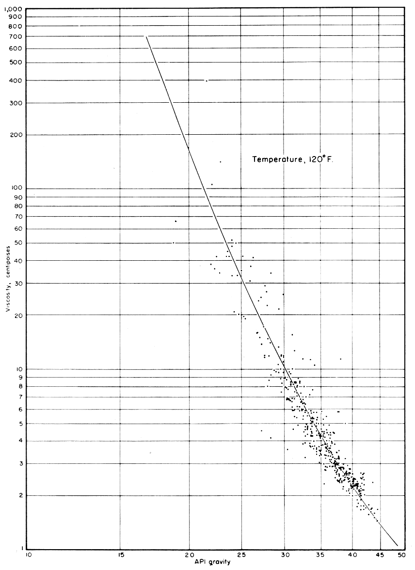
The range of viscosities measured is given in Table 1 and is shown graphically in Figures 2, 3, and 4.
Figure 2--Chart showing viscosity of crude oil at 70° F and atmospheric presure.
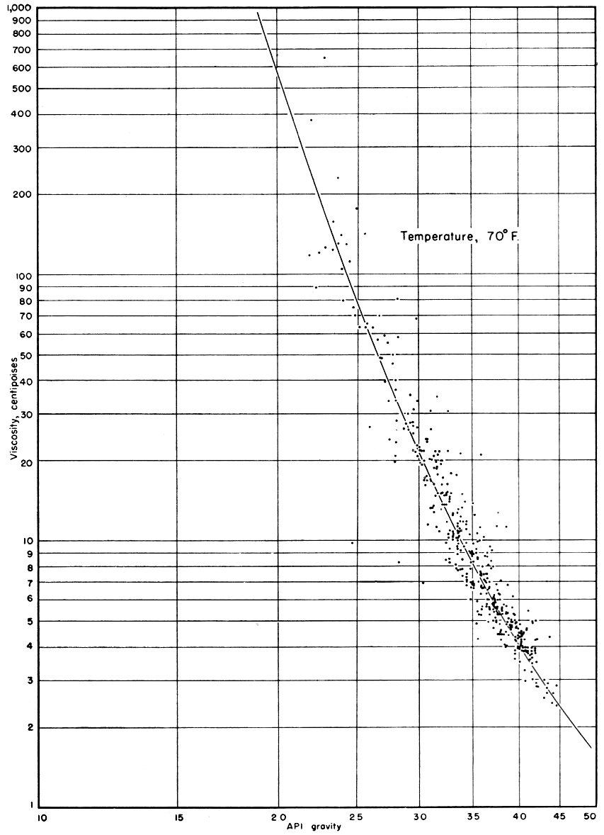
Figure 3--Chart showing viscosity of crude oil at 100° F and atmospheric presure.
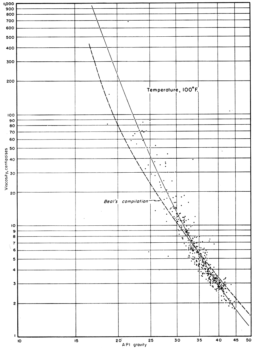
Figure 4--Chart showing viscosity of crude oil at 120° F and atmospheric presure.
Interfacial Tension: The interfacial tension of the first few samples was measured by means of the double cylinder apparatus described by Bartell (1938). This method consists of placing oil in one of the cylinders and water in the other and determining the height to which water rises in a capillary tube located vertically between the two liquids. By taking into consideration the difference in density between the oil and water, a simple calculation will give the numerical value of interfacial tension. The measurements were made at 80° F., as this temperature could be maintained conveniently.
The double cylinder method of determining interfacial tension was time consuming and for this reason other methods were considered. The ring, Du Nouy, or tensiometer method of measuring surface tension or interfacial tension was chosen as the most practical. This method measures the force necessary to draw a platinum ring of known dimensions through the interface formed between the oil and water. Measurements were made near 80° F. whenever it was possible to maintain the room temperature at this level. Values measured at other temperatures were corrected to 80° F. by Sugden's equations.
The A.P.I. gravity of crude oil is the physical property most universally available because it is the basis for determining the selling price. Usually the A.P.I. gravity of the oil produced is a matter of record even in the old fields that have been abandoned for several years. Therefore, gravity was used as a basis for correlating other physical properties.
The viscosity data were correlated with the A.P.I. gravity of the oil. Several methods of correlation were tried in an attempt to present the data in the best possible manner. It was found that by plotting the logarithms of the gravities against the logarithms of the viscosities, a very nearly straight line was formed. For this reason the A.P.I. gravity was plotted against the viscosity on log-log paper, the results of which are shown in Figures 2, 3, 4, and 5. The A.P.I. gravity scale has been expanded to three times that of the viscosity scale. The data show some scattering, but they correlate extremely well considering the geographic distribution of the samples as well as the difference in type of formation from which the samples were obtained.
Figure 5--Chart showing comparison of viscosity of crude oil at 70°, 100°, 120° F.
Plotting the gravity against the viscosity of samples obtained from similar formations resulted in no improvement in the correlation. Therefore, it seems that the general character of all the oils in eastern Kansas is very similar.
The dashed line in Figure 3, obtained from a correlation by Beal (1946), represents viscosity measurements on 650 gas-free crude oil samples taken from 492 oil fields, 358 of which are in the United States. The correlations agree very well in the range where a mass of data is available--that is, between A.P.I. gravities of 30 and 50. The divergence at the lower gravities probably is due to the experimental difficulties in measuring the viscosity of such heavy oil.
Figure 5 shows the plot of viscosity vs. gravity for the three temperatures as shown in Figures 2, 3, and 4. This plot shows the similarity of the three curves and also allows use of the curves for comparison with other samples of crude oil.
The data in Figure 5 were cross plotted against temperature to give a family of lines of temperature vs. viscosity (Fig. 6) for the various A.P.I. gravities. By means of Figure 6 it should be possible to obtain the viscosity of any eastern Kansas crude oil at almost any temperature encountered in producing reservoirs of eastern Kansas.
An attempt to correlate interfacial tension measurements with gravity of the oil indicated that there is no apparent correlation between these two physical properties. Inasmuch as the viscosity of the oils correlated with the gravity, it would appear that there is no correlation between viscosity and interfacial tension. Therefore no effort was made to correlate these properties.
Figure 6--Chart showing viscosity of various crude oils as a function of temperature.
American Society for Testing Materials (1949) A.S.T.M. Standards en Petroleum Products and Lubricants: Am. Soc. Testing Materials, Philadelphia, pp. 1-1420.
Bartell, F. E. (1938) Laboratory manual of colloid and surface chemistry: Edwards Bros., Ann Arbor, Mich., pp. 1-187, fig. 1-42,
Beal, Carlton (1946) Viscosity of air, water, natural gas, crude oil, and its associated gasses at oil field temperatures and pressures: A.I.M.E. Trans., Petroleum Branch, v. 165, p. 94.
Jewett, J. M. (1954) Oil and gas in eastern Kansas: Kansas Geol. Survey, Bull. 104, pp. 1-397, fig. 1-59, pl. 1.
U. S. Dept. of Commerce (1936) National standard petroleum oil tables: Natl. Bur. Standards, Cir. C-410, pp. 1-175, fig. 1-2.
Ver Wiebe, W. A., and others (1954) Oil and gas developments in Kansas during 1953: Kansas Geol. Survey, Bull. 107, pp. 1-204, fig. 1-16, pl. 1-2.
Kansas Geological Survey, Energy Resources
Placed on web July 28, 2008; originally published in November 1955.
Comments to webadmin@kgs.ku.edu
The URL for this page is http://www.kgs.ku.edu/Publications/Bulletins/114_7/index.html