Kansas Geological Survey, Bulletin 109, Part 6, originally published in 1954
Originally published in 1954 as Kansas Geological Survey Bulletin 109, Part 6. This is, in general, the original text as published. The information has not been updated.
Graded erosional slopes of several types occur in western Kansas. As these surfaces are developed on relatively nonresistant and uniform rocks they present particularly favorable conditions for study of their origin. They are described in three groups: (1) graded surfaces of the interfluves, judged to have developed prior to Illinoian time; (2) flanking pediments, controlled by the position of an adjacent stream course, that have developed during late Pleistocene time; and (3) "pedimented tributary" valleys or "concavo-convex" gullies that have developed since mid-Wisconsinan time. It is concluded that although lateral planation by minor streams may have been an important factor in the origin of the first category, the forms classed in the third category were cut by some form of surface sheet action of running water.
In recent years literature on physiography has contained repeated mention of the importance of slopes (Bryan, 1940) and processes operating on them in the development of land forms. Strahler (1950, 1952) has particularly stressed the importance of quantitative investigations and the analytical approach. Recognition of the importance of graded slopes was not lacking in the earlier literature, In 1899 Davis made the following statement (p. 266):
It is briefly stated that valleys are eroded by their rivers, yet there is a vast amount of work performed in the erosion of valleys in which rivers have no part. It is true that rivers deepen the valleys in the youth and widen the valley floors during the maturity and old age of a cycle, and that they carry to the sea the waste denuded from the land; it is this work of transportation to the sea that is peculiarly the function of rivers, but the material to be transported is supplied chiefly by the action of the weather on the steeper consequent slopes and on the valley sides.
In study of slopes, as in study of other natural phenomena, the more that distracting elements can be eliminated the more readily we may come to an answer. In development of slopes one of the strongest of the distracting elements is alternation of bedrock types; therefore, an area where the slopes are developed in materials similar from top to bottom should present favorable circumstances for their study. Near uniformity of rock materials is to be found underlying slopes along many of the minor valleys and some of the major valleys of the High Plains (Frye, 1946) region of Kansas.
During the past 15 years I have had opportunity to observe critically the topography of western Kansas, and although slope measurements and mathematical analysis have not been made, it is judged worth while, in the hope that some future worker may be able to examine them in a more analytical manner, to describe briefly some of these surfaces which are clearly not the result of lateral planation by major streams and which are developed in homogeneous rocks.
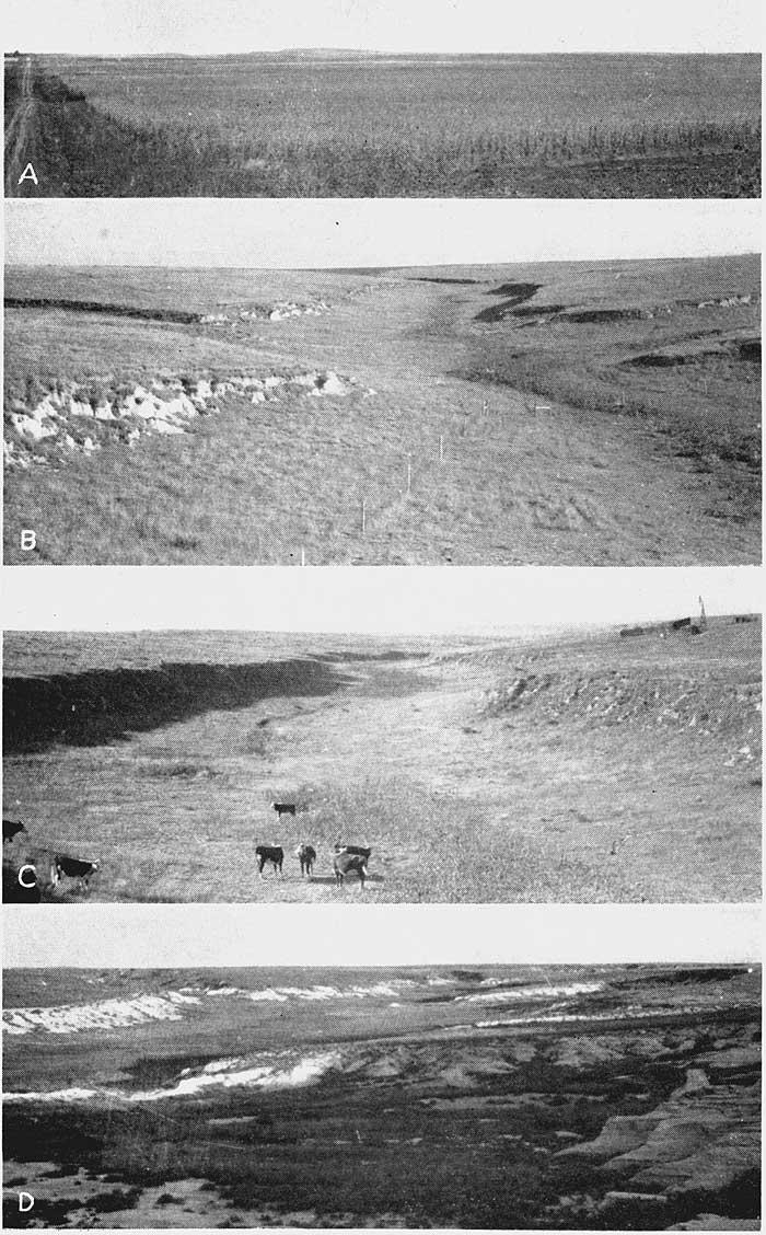
For purposes of description graded slopes will be considered in three general categories: (1) graded surfaces in the interfluves (Pl. 1A), (2) flanking, pediments (Frye and Smith, 1942; Frye and Leonard, 1952) along major valleys (Pl. 2B, C), and (3) "pedimented tributaries" or "concavo-convex gullies" (Pl. 1B, C, D),
Broad graded surfaces between valleys are the least common of the three categories. They occur in the area underlain by the Carlile shale (Pl. 1A; Fig. 1A) and the Smoky Hill chalky shale member of the Niobrara formation of Cretaceous age. In Ness, Rush, and Hodgeman Counties and northeastward along the Carlile shale outcrop belt such surfaces have their greatest extent and resemble dissected low-gradient pediments sweeping outward from the Fort Hays escarpment. Therefore they may be genetically similar to the flanking pediments that form the marginal zones of many of the major valleys of western Kansas. Somewhat similar surfaces are to be found marginal to the Greenhorn limestone escarpment where they are developed in Graneros shale, Dakota formation, and Kiowa shale (Cretaceous).
Plate 1. Graded slopes in northwestern Kansas. A, Smoothly cut surface on Carlile shale (Cretaceous) with thin discontinuous Pleistocene cover, extending outward from the Fort Hays limestone escarpment in the distance; 6 miles west of Ness City, Kansas (1945). B, View south (upstream) along a tributary to Beaver Creek, NW sec. 10, T. 3 S., R. 32 W., Rawlins County. Surfaces entirely in late Pleistocene loess underlain by Pliocene Ogallala formation (1945). C, View north (downstream) along a tributary to Beaver Creek, SW sec. 4, T. 3 S., R. 32 W., Rawlins County. Surface entirely in late Pleistocene loess underlain by Pliocene Ogallala formation (1945). D, View south (upstream) along a tributary to Twin Butte Creek, southern Logan County. Surfaces developed entirely in Smoky Hill chalky shale member of the Cretaceous Niobrara formation with thin veneer of late Pleistocene loess on upland surfaces (1950).
Where well developed and undissected these features present smooth gently sloping almost unbroken surfaces with a striking lack of bedrock exposures in spite of the thinness of the soil cover. Locally thin veneers of late Pleistocene loess mantle the gentle slopes; stratigraphy of these loesses indicates that in general the surfaces were developed prior to Illinoian time. The steeper parts of these "flat-land pediments" (Tator, 1953, p. 51) are locally veneered with colluvium that reflects a predominint source in the adjacent escarpment. In the down-slope portion they locally merge with flanking pediments along the major valleys, and in fact, the two forms seem to be transitional with each other.
In 1952 Frye and Leonard proposed the term "flanking pediments" for pediments of the semiarid type developed along major and minor valleys in central Kansas from their flanking position with respect to the stream courses that control them. Although Tator (1953, p. 51) has objected to this term on the basis that his "piedmont pediment" is also a "flanking pediment" in a positional sense, nevertheless it is retained for use in the High Plains because of the paramount importance of the flanking position and the fact that the term has not been used previously in a formal sense and therefore is not confusing.
Flanking pediments present broad straight to concave smooth surfaces (Fig. 1B, C, D), locally marked by inselberge, which meet the steep valley-side wall with a more or less distinct transitional curve. They are developed in Permian, Cretaceous, Pliocene, and Pleistocene rocks, but have their most ideal expression in thick relatively homogeneous or massive rocks typified by the thick Smoky Hill chalky shale member of the Cretaceous Niobrara formation. Flanking pediments have their most extensive development long the valley of Cimarron River where only one cycle of pedimentation is evident and the valley-side slopes are graded to the present position of the river (Pl. 2C; Fig. 1D); along the valley of Smoky Hill River where several cycles of Pleistocene pediments are preserved and the youngest set of valley-side slopes is graded to the present position of the river; along portions of the valleys of the upper Saline (Pl. 2B) and Solomon Rivers where local fragments of an earlier cycle are preserved above well-developed active surfaces; and in Barber and adjacent counties where several cycles of relatively small-scale flanking pediments occur along minor valleys and locally along the valleys of Medicine Lodge and Chikaskia Rivers.
Figure 1--Profiles of graded erosional slopes in western Kansas. A, Pre-Illinoian erosion surface in interstream area dissected in post-Illinoian Pleistocene time. Scarp is in Fort Hays limestone and graded surface developed in Carlile shale (Cretaceous). B, Idealized flanking pediment. C, Flanking pediment developed in the Smoky Hill chalky shale member, Niobrara formation (Cretaceous). D, Flanking pediments of Cimarron River Valley developed in Pliocene and Pleistocene alluvial deposits, largely non-indurated. E, F, "Concavo-convex" gully developed in late Pleistocene loess overlying the Pliocene Ogallala formation. G, Generalized cross profile of "concavo-convex" gullies of northwestern Kansas.
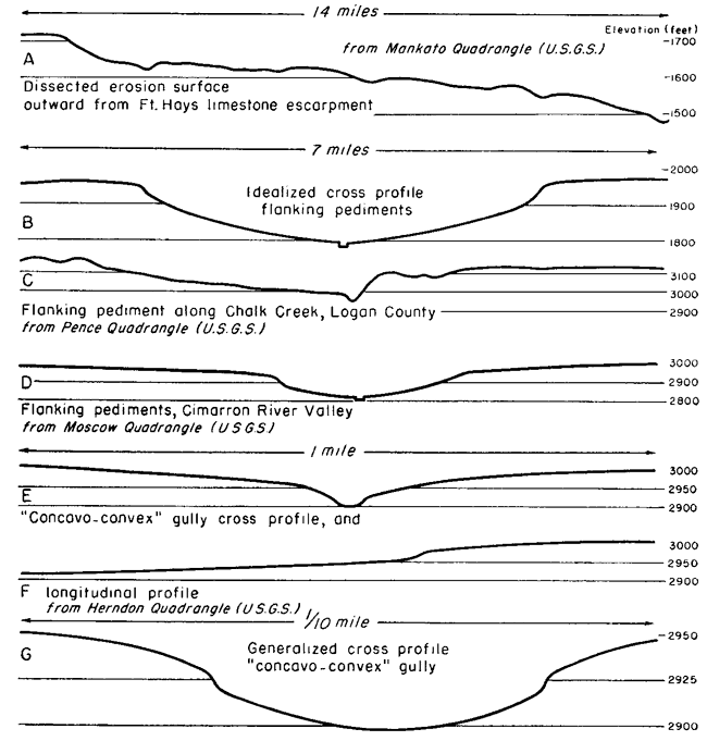
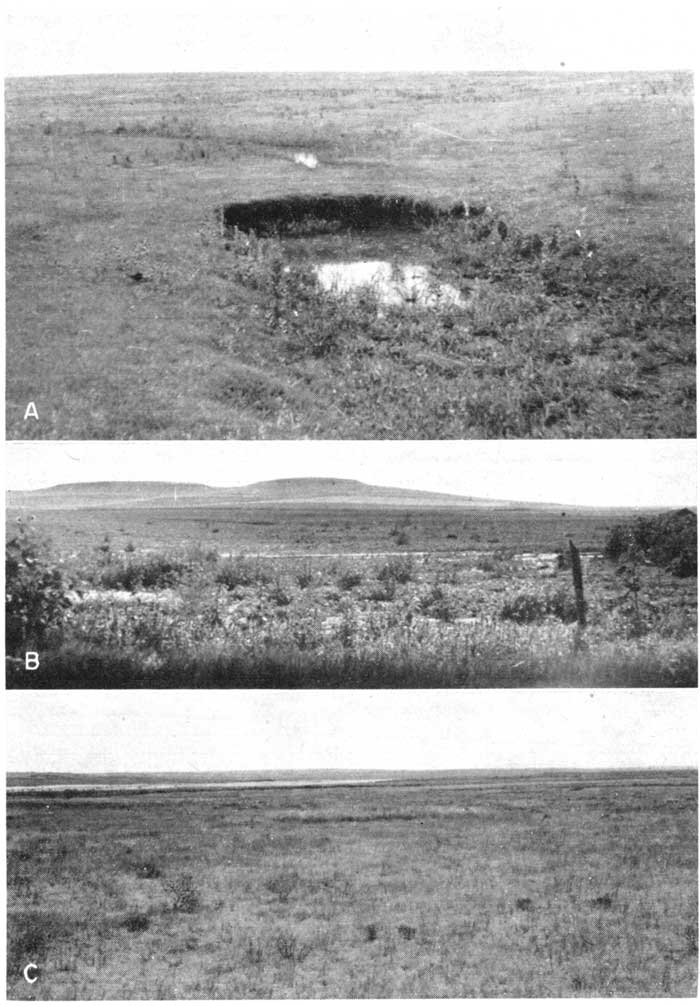
Plate 2. Flanking pedinients and pools in western Kansas. A, Discontinuous channel pools, typical of minor streams in western Kansas prior to cultivation but now rare. Slopes are developed on Cretaceous Dakota formation, sec. 11, T. 13 S., R. 7 W., Lincoln County (1948). B, Flanking pediment on south side of Saline River Valley, sec. 31, T. 12 S., R. 10 W., Lincoln County. Pediment surface is cut in the Dakota formation, Graneros Shale, and Greenhorn limestone (Cretaceous) and is thinly veneered witli a sheet of colluvium composed of loess and materials from the bedrock (1948). C, View southwestward down the flanking pediment surface toward the channel of Cimarron River, southeastern Seward County. This smooth and relatively unbroken surface is cut in fluviatile sediments of Pliocene and Pleistocene age and has a thin discontinuous veneer (1940).
The graded surfaces along Cimarron River Valley are developed in uncemented, fluvatile sediments of Pliocene and Pleistocene age and are discontinuously veneered with colluvium and locally derived side-stream alluvium which in places is as much as 10 to 12 feet thick. Fossil snails which have been found in the surficial deposits at a few localities indicate an age that is certainly post-Bradyan Wisconsinan and Probably post-Wisconsinan, (A. Byron Leonard, personal communication) thus indicating that the single set of flanking peliments of Cimarron Valley is Recent in culmination.
The graded slopes of the Smoky Hill River Valley are developed in relatively uniform chalky sl-.ales of late Cretaceous age. Three sets of surfaces are dated with respect to the time of theilactive development as Kansan-Illinolan, earlv Wisconsinan, and late Wisconsinan. Age determinations are based on the dating of alluvial terraces (Frye and Leonard, 1952) to which these three surfaces are graded, and the stratigraphy of the loesses on the older ones. These surfaces have a discontinuous veneer of colluvium and the older cycles are mantled extensively with late Pleistocene loess. The loesses of the Illinolan-Kansan surface contain a well-developed Sangamon soil overlain by Peoria loess at many places, thus indicating that the land form has been modified little since Illinoian time.
The flanking pediments of the upper Saline and Solomon Valleys are developed in rocks ranging from well-indurated sandstones and chalky limestones to shales and clays of the Kiowa, Dakota, Graneros, and Greenhorn formations of Cretaceous age. Thin colluvial and loess veneers are common, and although all these surfaces must have developed after mid-Pleistocene time, it is difficult to date them more closely.
Unusually well-defined flanking pediments occur in the slltstone, shale, and gypsum of the Permian redbeds in Barber and adjacent counties of southern Kansas. Here, primarily along minor valleys, three distinct cycles of pediments are preserved. Although the surfaces have not been dated closely the highest and oldest has head walls cut in Crete (Illinoian) gravels and therefore the sequence of surfaces must be entirely post-Illinoian in age. At many places there is a striking lithologic contrast between the bedrock in which the surfaces are cut and the thin colluvial-alluvial veneer. Pleistocene sand and gravel exposed in the head walls of the highest and oldest cycle has furnished a surficial coating of several feet of arkosic gravel mixed with red silt and clay which rests directly on the eroded surface of Permian redbeds.
The most striking of the graded slope features of western Kansas, and one essentially lacking previous description, are the "pedimented tributary" valleys or "concavo-convex" gullies (Pl. 1B, C, D; Pl. 2A; Fig. 1E, F, G). These features are developed extensively only in the northwestern part of the State. In areas where the native sod has not been broken by cultivation they lack a continuous central channel. Discontinuous channel pools (Pl. 2A) with a sod "caprock" at the upstream side are developed locally in their bottoms; in areas where the surface has been plowed, a sharp gully commonly is progressing headward along the bottom. These small valleys are particularly distinguished by distinct lateral scarps, ranging in height from 18 inches to 5 or 6 feet, roughly paralleling the trend of the valley on both sides and marking the position of change in slope curvature from concave in the gully (between the scarps) to convex on the upper slopes extending into the divide areas (Fig. 1).
It is established that these small valleys are erosional forms because only in the central part of the concave valley floor does any alluvium occur, and even where it is present it is commonly quite thin. However, adjacent to major valleys this erosional floor locally merges with the surface of a low late Pleistocene alluvial terrace associated with the major stream valley. The age of development is known to be late Wisconsinan to Recent as not only are the floors of some of them graded to the surfaces of low late Wisconsinan terraces but also some of them are developed in early Wisconsinan loess (Pl. 1B, C). At a few places (e.g., central Rawlins County) two-stage valleys of this type have been observed with a second small scarp parallel to and higher on the slope than the inner pair of scarps. However, where this has been observed the slope curvature between the two scarps is convex in conformity to the slopes of the interfluve, rather than concave in conformity to the valley bottom.
In every place where "concavo-convex" gullies have been observed they are developed in rocks of uniform lithology. They are most common and most conspicuous in the northwestern area where approximately 30 feet of Wisconsinan loess overlies the Ogallala formation; in that area the position of the pre-loess valleys cut, in the Ogallala formation may have localized the positions of the present tributaries. The second most common bedrock lithology is Cretaceous chalky shale (Pl. 1D). Where developed in this bedrock the curvature of the slopes is less than where the gullies occur in loess, and the marginal scarps are less regular and uniform although equally high and distinct.
The origin of sloping planated rock surfaces, or pediments, has been a subject of controversy since Gilbert's descriptions in 1877. Tator (1952, p. 295) has recently summarized this divergence of opinion as follows:
Two major theories of origin have proven acceptable to students of this subject. One proposes that rock planation is a result of lateral corrasion by steep-gradient, ephemeral streams; the other contends that weathering of escarpment faces causes their retreat, leaving as a consequence a relatively planate bedrock surface, Some recent workers have combined certain tenets of these two concepts.
All the High Plains slope features described here are developed in rocks of low to very low resistance to erosion, in a "flat lands" or plains environment, with a semiarid to subhumid climate, and they are all controlled by through-flowing or external drainage. Although they are here described in three categories on the basis of size, position, and age, the groups are transitional with one another and are judged to have genetic similarities. The larger features that transcend the interfluves are probably pre-Illinoian in culmination; the flanking pediments are post-Illinoian Pleistocene; and the "concavo-convex" gullies are late Wisconsinan and Recent. Therefore, the three groups may represent at least in part three stages of development involving the same processes.
Davis (1902) championed the use of the concept of "grade" as applied to slopes as well as streams and stated (pp. 101-102):
... every bare ledge on a mountain side will, in time, be graded (or consumed) by the headward growth of the graded slope next below it, just as every ledge of rocks that makes a fill or rapid at the head of a reach will, in time, be obliterated by the up-stream extension of the graded reach.
The same fundamental concept was later expressed by Penck (1924, Czech and Boswell translation, 1953, p. 133) as follows:
A rock wall, subjected to denudation, retreats backwards upslope, and a gentler declivity, the basal slope, is seen to form at its expense and to grow upslope by the same amount as the cliff vanishes.
The conclusion thus expressed that graded erosional slopes are controlled by the position of the adjacent master stream has been reiterated (e.g., Bryan, 1940) and it seems needless to belabor it further. Furthermore, the slight to strong concavity of the marginal slopes fits Penck's category of development in response to a stable base of control which is consistent with the geological evidence of the region. As neither of these points is at issue, we will turn our attention to the detailed processes operative in their erosion.
It is difficult indeed to gain from a perusal of the literature a satisfactory understanding of what takes place on an erosional slope away from a flood plain. In 1908 Fenneman proposed a concept of slope reduction by "unconcentrated wash" and explained the development of convex slopes without visible gullies or channels by this mechanism. He contended that the change from the "overloaded rill" condition to gully cutting is sudden and that the convex curvature of the upper slopes changes abruptly to a concave profile of the lower gully. The elements of the "concavo-convex" gully may be fitted to Fenneman's scheme if we liken the inner concave surface to the gully profile, the marginal scarp to the critical limit of the "overloaded rill" condition, and the upper convex slope to the area subject to "unconcentrated wash."
Horton's (1941) "belt of no erosion" may be in part comparable to Fenneman's zone of unconcentrated wash. It might be profitable to examine Horton's concepts for possible application to graded slopes in the High Plains region.
General summaries of the hypotheses of pediment origin have been given, among others, by von Engeln (1942, pp. 433-437) and at greater length by Cotton (1942, pp. 29-58) who suggests that lateral planation by minor streams may play a less significant role in arid than in semiarid regions.
Flanking pediments in western Kansas have recently been described by Frye and Leonard (1952, pp. 26-28). They state that rock debris as a sheet is transported across the surface by minor stream action, creep or lubricated creep, and rill wash; Iubricated creep seemingly is an important process in areas where the pediment is cut on rock of low permeability as the debris sheet has a markedly higher permeability than the underlying bedrock and therefore a saturated zone is maintained for extended periods in the basal part of the veneer.
It is not the purpose of this discussion to attempt an answer for the controversial question of pediment origin. It seems likely in fact that among the diverse land forms placed under the general heading of "pediment" several prime modes of cutting may have been operative at different places and under different conditions. However, it is judged that from the data at hand certain minimum conclusions may be drawn concerning the origin of graded slopes in the central High Plains. The features here designated "concavo-convex" gullies are clearly not cut by lateral planation of streams--large or small--but rather are developed by some form of sheet action by running water. Whether or not this action conforms in detail to the process described by Fenneman as "unconcentrated wash" remains to be determined. The larger features, classed as flanking pediments, are importantly influenced, in addition to surface sheet action, by colluviation, creep, or lubricated creep (whichever term is more appealing); and the graded slopes that transcend the interfluves display alluvial materials that suggest that lateral planation by minor streams may have been a contributing factor.
Bryan, Kirk (1940) The retreat of slopes: Assoc. Am. Geographers Annals, vol. 30, pp. 254-268.
Cotton, C. A. (1942) Climatic accidents in landscape making: John Wiley & Sons, New York, pp. 1-354.
Davis, W. M. (1899) The geographical cycle: Geographical Jour., vol. 14, pp. 481-504; cited from Geographical Essays, 1909, pp. 249-278.
Davis, W. M. (1902) Baselevel, grade and peneplain: Jour. Geology, vol. 10, no. 1, pp. 77-111.
Fenneman, N. M. (1908) Some features of erosion by unconcentrated wash: Jour. Geology, vol. 16, no. 8, pp. 746-754.
Frye, J. C. (1946) The High Plains surface in Kansas: Kansas Acad. Sci. Trans., vol. 49, no. 1, pp. 71-86.
Frye, J. C., and Leonard, A. B. (1952) Pleistocene geology of Kansas: Kansas Geol. Survey, Bull. 99, pp. 1-230.
Frye, J. C., and Smith, H. T. U. (1942) Preliminary observations on pediment-like slopes in the central High Plains: Jour. Geomorphology, vol. 5, no. 3, pp. 215-221.
Gilbert, G. K. (1877) Report on the geology of the Henry Mountains, Utah: U. S. Geographical and Geol. Survey of the Rocky Mountain Region, pp. 1-160.
Horton, E. E. (1941) Sheet-erosion--present and past: Am. Geophys. Union Trans., 1941, pt. 2, pp. 299-305.
Penck, Walther (1924) Morphological analysis of land forms: Translated by Hella Czech and Katharine Cumming Boswell, Macmillan and Co., London, 1953, pp. 1-299.
Strahler, A. N. (1950) Davis' concepts of slope development viewed in the light of recent quantitative investigations: Assoc. Am. Geographers Annals, vol. 40, no. 3, pp. 209-213.
Strahler, A. N. (1952) Dynamic basis of geomorphology: Geol. Soc. America Bull., vol. 63, no. 9, pp. 923-938.
Tator, B. A. (1952,) Pediment characteristics and terminology, Part 1: Assoc. Am. Geographers Annals, vol. 42, no. 4, pp. 295-317.
Tator, B. A. (1953) Pediment characteristics and terminology, Part 2: Assoc. Am. Geographers Annals, vol. 43, no. 1, pp. 47-53.
von Engeln, O. D. (1942) Geomorphology: The Macmillan Co., New York, pp. 1-655.
Kansas Geological Survey, Geology
Placed on web Aug. 9, 2006; originally published in 1954.
Comments to webadmin@kgs.ku.edu
The URL for this page is http://www.kgs.ku.edu/Publications/Bulletins/106_6/index.html