![]()
Prev Page--General Considerations || Next Page--Glacial Debris
Chapter II—River Valleys
In Kansas all our river valleys, excepting the smallest creeks, have great width and the flood plains, or river alluviums, have varying thickness from ten feet to a hundred feet or more. The Kansas River valley from Junction City to the Missouri River averages four or five miles in width. The flood plain material naturally varies in thickness. At Lawrence it is about sixty feet thick, and doubtless in some places is much thicker. The Arkansas River valley varies in width more than a river valley usually does, due to certain combinations of lithologic conditions which need not here be discussed. The thickness of this river alluvial material varies from fifteen or twenty feet in some places to three hundred or more in others. Similar statements may be made of the Marais des Cygnes River, of the Neosho River, and the Verdigris River, although exact figures for width of channel and thickness of alluvial material can not be given for all of them.
Much misunderstanding exists in the public mind regarding water conditions in river valleys. It may be well, therefore, to give a brief explanation of facts as they actually obtain.
A river valley is a channel or ditch chiseled into the upper surface of the rock mass. Flowing water has done the chiseling. If the rock masses vary in character then the depth and width of the valley may vary accordingly. Water flowing through such a valley wears away the rock masses and carries the products of erosion down stream. The walls of the valley, the bluffs, as they are commonly called, being thus subject to erosion, tend to grow farther and farther apart so that the valley grows ever wider. Rivers and their valleys are creatures of circumstances. There was a time in the history of the world when ocean water covered the western end of Kansas and Cretaceous rocks were forming. The eastern end of the state was drained westward, so that our rivers in those days flowed west. Subsequently, the great Rocky Mountain area was elevated and the ocean water driven out from western Kansas and the Great Plains were lifted so that surface water was forced to flow to the east. That was the beginning of our present drainage system. Each individual stream passed through various vicissitudes, and doubtless many of the earlier ones were destroyed and new ones created to take their places. It is not my purpose here to discuss Nature's mode of forming rivers and river valleys. It is important, however, to know that valleys have been formed slowly, with more or less irregularity, and that in the course of time these same river valleys in a measure have been refilled with sand and soil and other surface materials. The immediate water channel of each river valley migrates from place to place across the valley, and builds up the so-called flood plains with materials held in suspension and carried along during times of flood. In general this material is washed down from the uplands. A great flood of a large river usually results in filling up the valley upon an average of one to three inches with materials brought down from the uplands.
The bottom of the river valley proper is the stratified rock masses and will or will not form a floor through which water can not pass, depending upon the degree of porosity of such rocks. Usually this floor may be looked upon as water tight throughout the greater part of the course of a stream, because much of the rock masses primarily are water tight and the mud of the river fills up and chokes up the pores in the porous rocks.
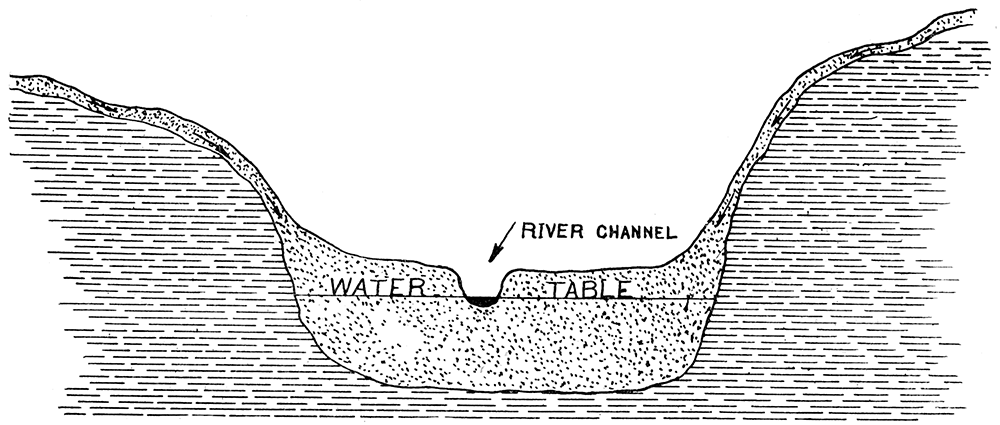
A river valley, therefore, is a greater or lesser ditch cut into the rocks, with a floor substantially water tight. Piled upon this floor is a mass of loose, porous material which allows rain water to soak down into it and flow through it in accordance with the laws of ground water movements already discussed in chapter 1. If rains are copious throughout the drainage area of the river the river valley will be substantially full of water. The immediate river channel is a portion of the valley, from which the alluvial material is constantly carried away by the flowing water, so that a lesser ditch is made in the soft material filling the greater ditch. This is represented in figure 4. Rain water falling upon the uplands works its way down into the river valley. Only a small portion of it actually enters the river channel because such large portions are absorbed by the loose material of the river flood plain. The water thus absorbed has its velocity checked and can work its way toward the river channel by very slow paces. Gradually it moves down stream and ultimately much of it seeps out into the river channel itself. The ground water in a river valley, therefore, is rain water which has not yet gotten into the river channel, but is working its way toward the channel, and is not water which has been in the channel working its way outward. Here is where so many people have wrong ideas. It is thought by many people that the water in a river valley has worked its way outward from the channel itself. It is fortunate for us that this idea is erroneous, because, were it correct, we would have but a small part of the water within our river valleys which we actually do have. How much better it is for us that nature has kindly filled the river valley full of water and permits the river slowly to carry it away, rather than to have the river valley with no water in it except what might work its way out from the river channel. As it is the river valley becomes a great storehouse for water.
Figure 4—representing a modern river valley produced by erosion cutting a channel down into the solid rock. Later, sediment of various kinds has partially refilled the valley, as shown, leaving the actual present river channel occupying a narrow ditch in the alluvium material. Rain water falling upon adjacent uplands and the river valley fill the valley with water up to the water in the present river channel, as shown.
A little calculation will show some interesting facts. Suppose we have a valley like the Kansas River valley, that averages five miles wide, and suppose the river channel on the whole lies in the middle of the valley. Rain water working its way down the hillsides and into the valley must travel an average of two and a half miles from the outer sides of the valley before it can enter the channel in the form of seeps. If water travels through such material eight feet per day, as was found to be true for the Arkansas valley at Garden City, then it would require 660 days for such water to travel one mile, or 1650 days, or about 4 1/2 years, to travel 2 1/2 miles, in order to reach the river channel. Should conditions be such that water will travel 17 feet per day, as was found to be the rate at St. Francis, it would still require more than two years for water to migrate from the bluff lines down to the river channel. Actually, water upon entering a river valley from the uplands soon begins flowing down stream, angling towards the channel. This makes the distance of travel greater than above assumed, and the time correspondingly increased for water to reach the channel after it has entered the river valley. By and by, however, a large proportion of such water reaches the river channel in the form of seeps and sustains the flow of water in the channel during periods between rains. If one will consider how small a fraction of the time water actually flows over the surface of the land into streams one can readily see that all streams would become dry within a few days after a rain were it not for the seepage of ground water from the river flood plain into the river channels. It is this continuous seepage which maintains the flow of rivers.
During protracted drouths the seepage is sufficient to lower the water table throughout the entire flood plain, which in turn checks the seepage, and hence decreases the flow in the stream. Should a drouth be sufficiently severe, seepage would ultimately lower the water table throughout the flood plain to a level with the bottom of the channel, and to even greater depth through evaporation. The amount of water still left in the river valley, therefore, would depend upon the depth of the valley proper below the river channel, that is, the distance from the bottom of the river channel down to the floor of the river valley. As already explained, this may be a few feet, or it may be even hundreds of feet, and therefore the amount of water available for wells in periods of extreme drouth will vary with the general character of the river valley.
A limited exception should be made to the general explanations above given. If from some cause there should be a rapid rise in a river without a corresponding local rainfall, the water level in the river channel will be lifted above the water table throughout the river valley. In such cases water to a varying amount works its way from the river channel outward and spreads partially across the river flood plain and lifts the water table accordingly.
Many careful observations have been made at different places and different times which substantiate the above explanations. Perhaps the most detailed investigation made in Kansas was that on the Arkansas River valley in 1904 made by Dr. Charles S. Slichter, of the U. S. Geological Survey, and published in Water Supply and Irrigation Paper No. 153 [available online]. He and his assistants determined that for the Arkansas River valley at and near Garden City the water table sloped down stream an average of 7.5 feet per mile and from bluff lands in toward the river from 2 to 3 feet per mile during ordinary stages of the river. If, however, the river became flooded by heavy rains to the west, without corresponding rains in the vicinity of Garden City, then the water table near the channel was raised and water actually flowed from the river channel out through the sands into the river valley for a short distance. They further ascertained that a heavy rain at Garden City would materially raise the water table in the valley, and that with surprising quickness, and they decided that an average of 60 per cent of local rainfall worked its way downward and joined the general ground water. Their general summaries may be here quoted:
"1. The underflow of Arkansas River moves at an average rate of 8 feet per twenty-four hours, in the general direction of the valley.
"2. The water plane slopes to the east at the rate of 7.5 feet per mile, and toward the river at the rate of 2 to 3 feet per mile.
"3. The moving ground water extends several miles north from the river valley. No north or south limit was found.
"4. The rate of movement is very uniform.
"5. The underflow has its origin in the rainfall on the sand hills south of the river and on the bottom lands and plains north of the river.
"6. The sand hills constitute an essential part of the catchment area.
"7. The influence of the floods in the river upon the ground-water level does not extend one-half mile north or south of the channel.
"8. A heavy rain contributes more water to the underflow than a flood.
"9. On the sandy bottom lands 60 per cent of an ordinary rain reaches the water plane as a permanent contribution.
"10. The amount of dissolved solids in the underflow grows less with the depth and with the distance from the river channel.
"11. There is no appreciable run-off in the vicinity of Garden City, Kan. Practically all of the drainage is underground through the thick deposits of gravels.
"12. Carefully constructed wells in Arkansas valley are capable of yielding very large amounts of water. Each square foot of percolating surface of the well strainers can be relied upon to yield more than 0.25 gallon of water per minute under one-foot head.
"13. There is no indication of a decrease in the underflow at Garden City in the last five years. The city well showed the same specific capacity in 1904 that it had in 1899."
The application of above principles is of great importance in Kansas. Few river valleys can be found in the state which will not supply all the water desired by residents in the valleys, even through our most protracted drouths. As the floor of these valleys is quite irregular, as already mentioned, it may be at times that the water table will fall below the ridges of the floor so that wells which chance to be put down directly over such ridges will fail to reach water, although an abundance of it exists in other places in the valley.
River valley ground water is available for municipal supplies at practically every city and town along the larger rivers of the state. Along the Arkansas River this is very common and I think every town without exception has a municipal supply of this character. Along the Kansas River a few exceptions may be found. Kansas City uses river water direct. Lawrence and Topeka use water principally from wells, although occasionally river water is substituted in part. Manhattan uses water from wells close to the Blue River, but yet within the Kansas River valley where the ground waters of the two valleys coalesce. Abilene uses water from wells or springs, water which has not yet entered the Kansas River. Here a large and permanent amount of water is flowing from the sandy uplands down into the river valley. Abilene intercepts this water while on its journey to the river.
Many of our Kansas towns along similar streams have not resorted to ground water, but impound surface water in artificial lakes and depend upon them for their supply. Naturally, during a protracted drouth such impounded water becomes scarce and more or less undesirable for use, and hence the water supply is deficient and of bad quality. In some localities a prejudice seems to exist against ground water. Many people think it does not exist in sufficient quantities to be worth going after, even in face of the facts easily obtainable that it exists in large quantities. A remarkable case of this kind came to my attention this summer.
Late in August I was called to a thriving Kansas town, a county seat, located in the edge of a beautiful valley in southeast Kansas. Their water supply was from Fall River, a stream rising in northwest Greenwood County. Months had passed since a rainfall had put surface water into the river, and seepage had lowered the water table in the valley until but little water seeped out into the river channel. As a result water was very low in the river, and stagnant and undesirable in quality. The river valley proper, however, held much water, as was shown by wells on every farm for miles above and below. Although reduced to extreme necessity the citizens of this town were debating the question whether or not they should resort to wells for a supply, and this in face of the facts that a test well could be put down at a cost of $5, water found within 12 or 15 feet of the surface, and there was about 18 feet of water-bearing sand.
The valleys in Kansas most important as ground-water producers are the valleys of the following rivers:
| Arkansas Blue Caney Cimarron Delaware Kansas Marais des Cygnes Neosho |
Ninnescah Rattlesnake Republican Sappa Rivers Solomon Rivers Verdigris Walnut |
Some of the rivers given in above list are in the western part of the state and do not have typical river valleys, that is, their river valleys are not cut down into impervious rock masses, but rather spread laterally and connect with the general underflow of western Kansas. All of the rivers in the eastern part of the state, and occasionally a portion of those in the western, have their valleys cut down trough-like into the water-tight stratified rocks so that little if any of the water once in the valley trough escapes laterally. Under ordinary conditions large quantities of rain water falling upon the water sheds of such streams will ultimately join the ground water of the river valley. It should be remembered the floors of these river valleys, or troughs, are not uniform. Usually, especially. with the larger river valleys, a well put down at random within the flood plain area is sure to yield water in copious quantities. If, however, the floor of the valley should be sufficiently irregular to permit certain concealed ridges in the floor to rise above the water table, then a well put down over such a ridge would yield no water from the underflow.
The amount of water in such a river valley may vary greatly with circumstances. With a copious rainfall the tendency is to raise the water table, thus increasing the thickness of the water-bearing sand. This in turn tends to increase the slope or fall of the surface of the water, the water table, and thereby accelerate the flow of water down stream through the sand. These two tendencies in a way balance each other so that the depth to water in most of the river valleys does not vary many feet from year to year. At Lawrence, the Kansas River valley is about 5 miles wide, and where sounded in bridge building it is about 60 feet from the surface of the flood plain to the bottom of the river valley, or to the impervious floor. The average pumping distance throughout the valley is from 25 to 30 feet, leaving about 30 feet of water in the sand. Upon an average it may be assumed that about one-fifth the space occupied by the water-bearing sand is available water, so that we have here a total amount of water equal to a width of 5 miles and a depth of 6 feet. This mass of water, of course, is slowly moving down stream, but at what rate has not been determined. At Garden City, with a fall of 7.5 feet per mile, the rate of flow is 8 feet per day. Here we have a fall of less than 18 inches per mile so that probably the downstream flow does not exceed 3 or 4 feet per day. It will be seen, from this, that a drouth of a few months, or even a year, would hardly have any effect upon the volume of water held within the sand of the Kansas River valley unless it should be pumped many scores of times as rapidly as has yet been done. Stock water and water for municipalities will always be present in greatest of abundance.
Arkansas River
The Arkansas River rises in Colorado, crosses the state boundary into Kansas near Coolidge on the western end of the state, flows in general east and south, and passes out of the state into Oklahoma at Arkansas City, about 130 miles west from the east end of the state. From Coolidge to near Lakin the river valley is cut down into Cretaceous shale and limestone, which are exposed to view in the bluffs on the north side of the river. To the south, however, bluffs are not observable and a mass of "sand hills" from 5 to 10 miles wide borders the river. Eastward from Lakin almost to Wichita the river bluffs are composed of loose, porous, Tertiary material, with the Dakota sandstone formations visible for a short distance in the vicinity of Larned. From Wichita south to Arkansas City the bluffs on the east side of the river are composed of stratified rocks, and a portion of the rocks on the west side as well. Here is a stream, then, with varied conditions as to river bluffs, width of river valley, and also as to character of the floor underneath the flood plain material.
The thickness of flood plain material, that is, the distance down to the floor, is exceedingly variable. At Arkansas City some wells have reached it within 30 feet; at Great Bend it is about 90 feet; while according to Slichter+ it is about 311 feet at Garden City and only 39 feet at the so-called "Narrows" near Hartland (Dr. Charles S. Slichter, The Underflow in Arkansas Valley in Western Kansas, U. S. G. S. Water Supply and Irrigation Paper 153, page 51). I have no data for depth of floor westward to Colorado, but from general information it is evident the thickness varies in different places in Colorado as well as in Kansas. The valley proper extends upstream substantially to Canyon City where the water flows over rock masses without having much river alluvium deposited.
This irregularity of depth of floor of the Arkansas River valley, of course, would make a great variation in available ground water were it not for the fact that the water table throughout the valley is so near the surface an inexhaustible amount of water is available, and therefore there is no practical need of being concerned as to the actual amount of water-bearing sand, for the water will never become exhausted by pumping. Few determinations have been made of the speed of flow of this ground water. Slichter and his assistants made elaborate determinations in the vicinity of Garden City, as already stated, in the summer of 1904. They carried their investigations westward as far as Hartland. While they found quite a variation in rate of flow, due principally to the sudden change in inclination of water table through heavy rains, yet they found an average of about 8 feet per day down stream.. The direction of flow varied slightly from place to place, but in general, practically straight down stream with the river valley and entirely independent of the immediate crooks and turns in the present river channel. With no evidence to the contrary, and with appearances strongly in its favor, we may assume that throughout the entire Arkansas River valley in Kansas the rate of flow varies from about ten feet per day at the west end of the state, where the inclination of surface is greatest, to about 5 or 6 feet per day at Arkansas City, where the inclination of surface is least.
The width of the river valley varies exceedingly, from less than a mile at the Narrows near Hartland to 10 or 20 miles in places from Great Bend downward. In fact, this bold bend to the north in the vicinity of Great Bend has already been explained by assuming that the river has gradually slipped down the gently inclined bedding planes of the soft shales within the Dakota formation (Erasmus Haworth, Geological Survey of Kansas, vol. II, p. 31, Lawrence, Kan., 1897). Whether or not this assumption is correct, it is practically certain that the ground water of the river valley coalesces with the ground water from this great area south of Great Bend and the area following down the river to below Wichita. We may conclude, therefore, that in order to exhaust the supply in the river valley proper, virtually one would have to exhaust the supply from this wide area just outlined, and no one need have any fears of such a Herculean task ever being accomplished. Here is an area including all of the Arkansas River valley in Kansas, portions of Harvey and Sedgwick counties, all of Reno and Stafford counties, parts of Barton, Pawnee and Edwards counties, nearly all of Ford County, and substantially half of Gray, Finney, Kearny and Hamilton counties which have ground water in and connected with the Arkansas River valley in such quantities that no one need have any fear of the supply ever being exhausted. To prevent the reader from drawing a wrong conclusion by anticipation it should be added here that other parts of the counties named and adjoining counties may be equally well supplied with water, but discussion here is confined to the Arkansas River valley.
Blue River
The Blue River enters Kansas from Nebraska, crossing the line near the middle of Marshall County about a hundred miles west from the east end of Kansas, and enters the Kansas River at Manhattan. Throughout its course it flows almost straight south, its mouth being only 4 miles farther east than where it enters the state. It has cut is channel deep into the Permian rocks, which form a solid wall of stratified rocks on each side throughout its entire course. Its valley is about one mile wide, being a little wider near the mouth than at the northern part of the state. The flood plain alluvial material is not very thick, that is, the valley channel proper has not been cut very deep below the top of the flood plain material. About five miles above its mouth a dam built across the stream rests upon the solid rock, so that here the flood plain material probably is less than 20 feet thick. At Blue Rapids the stream has not yet succeeded in fully wearing away the limestone which crosses the valley and by its existence produces mild rapids and falls. In the aggregate, however, the valley has filled in enough to have the present river channel flowing over flood plain material throughout the greater part of its course, and therefore conditions are favorable for ground water within the valley held in place by the gravel, sand and soil of the river alluvium. This makes it possible to find water in wells located at random throughout the valley, which water is abundantly sufficient for all ordinary purposes during ordinary" seasons. In extremely dry weather, however, when the water table has been greatly reduced by seepage into the river channel and otherwise, it should be expected that here and there ridges in the floor will be higher than the water table, and hence wells which chance to be drilled over such ridges will become dry.
During the present summer water flowed continuously in the Blue River, although the amount of flow was reduced to a minimum. The river is so young physiographically that it has a number of riffles similar to those at Blue Rapids, only less prominent, and deep pools above such riffles, as is common with rivers of this character. Water was abundant in these pools all summer long, being supplied by seeps from the ground water of the valley. No accurate measurements have been made in this valley, but it is substantially certain that the water table on each side of the channel gradually rises away from the channel, as already described for the water table at Garden City.
From the above explanation it is safe to conclude that the Blue River valley has an abundance of water easily available by wells to supply all the needs likely to be placed upon it. An occasional well going dry in extremely dry weather should be explained as above mentioned and should not in any sense of the term condemn the entire valley.
Caney River
One branch of the Caney River rises in the southwestern part of Elk County and the other in the northwest part of Chautauqua County, The western fork is the larger of the two, but passes out of the state before it assumes sufficient size to warrant discussion here. The eastern fork flows southeast by way of Peru and Caney. Throughout the upper portion of the stream its valley is so narrow and shallow that it need not here be considered. Along the lower portions and farther south in Oklahoma the valley has sufficient width and depth to make it an important producer of water. Here we have the same conditions already explained for other streams. The flood plain material absorbs rainfall and water coming into it from the uplands. The ground water thus produced flows gradually down stream as in other river channels. No measurements have been made on the rate of flow in this valley. Its inclination of surface, however, is not very great and probably the flow does not exceed from 4 to 6 feet per day. The amount of water available has not been ascertained, but it is reasonably sure that the lower part of the valley would furnish all the water it is ever called upon to yield.
Cimarron River
The Cimarron River rises in southeastern Colorado, crosses the line into Kansas in the southwestern part of the state, flows in an easterly direction near the south line of the state, occasionally crossing and recrossing the boundary, and finally leaves the state, crossing southward into Oklahoma, about a hundred and thirty miles east of the southwest corner of the state, Throughout almost all of its course it is flowing across Tertiary formations which are water-bearing and which will be discussed later in this report. Neither its bluffs nor its valley here touches the regular stratified rocks, but are confined entirely to the loose porous Tertiary material. From southern Meade County to where it crosses the state line into Oklahoma it flows over the Red Beds into which, in places, it has cut a moderately deep channel and has built up a flood plain of considerable thickness.
Water conditions along the Cimarron in its upper course throughout the Tertiary area are substantially the same as the Tertiary provides elsewhere and will be discussed in a general way under the Tertiary. Portions of the valley have the Red Beds for floors, and wells here supply but little water, and this frequently is too highly mineralized for domestic use. It will not do, therefore, to make purely general statements about this valley from Meade County eastward similar to those made for the broad Arkansas River valley. Here and there the flood plain material furnishes an abundance of good water.
Delaware River
The upper tributaries of the Delaware River rise in the eastern and southeastern portions of Nemaha County, with lesser tributaries rising in Brown and Jackson counties. These several streams flow southeastward across southwestern Atchison County, forming the Delaware River which flows by way of Valley Falls, Ozawkie and Perry and enters the Kansas River opposite Lecompton. Throughout the upper portion of its course it flows over glacial debris which covers the northeastern part of the state. Here the narrow valleys of the several tributaries are well supplied with water and usually furnish an abundance of well water, even in dry times. Southward it comes in contact with the hard, carboniferous limestones and shales, into which it has cut its channel, forming a valley. Here and there it has not yet worn away the limestone beds which it crosses so that falls exists, such as at Valley Falls. The alluvial material in the valleys holds considerable ground water, in a way similar to that already described for other river valleys. These cataracts or falls, however, practically divide the ground water into pools so that but little, if any, water flows from one pool to another. Such conditions of course render the sum total of ground water, and hence its reliability as source of supply, much less favorable than is found in other streams. Nevertheless, large quantities of enduring water are found here and there in the valley, readily available as well water.
Throughout the last few miles of its course the valley of the Delaware coalesces with the. valley of the Kansas River and has the same general water conditions furnished by Kansas River.
Kansas River
The Kansas River rises close to the west end of the state and flows east and empties into the Missouri at Kansas City. Some of its tributaries bear a little to the north and pass up into Nebraska, where they are gathered into the Republican River which recrosses the state line back into Kansas a little east of the middle of the state. Throughout their upper portions the tributaries frequently cut down through the Tertiary covering of the West and form channels in the stratified rocks. This is quite irregular, so that frequently we find such channels for a distance, and farther down stream the channel has not reached the stratified rocks. From Ellsworth down along the Smoky Hill River, and from Scandia along the Republican, and Beloit along the Solomon, the valleys are quite well marked, and are trenches from 50 to 250 feet deep cut down into the stratified rocks. From here to the mouth of the stream we have typical river valleys with their flood plains and ground water and underflow reaching substantially from bluff to bluff.
Few soundings have been made along the Kansas River to find the exact depth of the river valley. At Lawrence, as above stated, it is about 60 feet at the north end of the wagon bridge across the river, and also at wells near by which furnish water for the city. It may reasonably be expected that in other places the depth varies considerably. At Lecompton, for example, water in the river flows immediately over stratified rock, so that here the impervious rock layers rise to the bottom of the present river channel. It may reasonably be expected that in some places the depth of the flood plain material is much greater than in others, possibly reaching from one hundred to two hundred feet.
Throughout the river valley, as above outlined, water seems to be available everywhere. The rich farm lands have attracted buyers so that the average farm is less than 160 acres. Under all ordinary circumstances the farmer simply puts a well down wherever he happens to want it and water is found at a uniform depth for each particular area. The water-bearing sand in the lower part of the Kansas River valley will average about 30 feet in thickness, about 20 per cent of which is water, making the equivalent of a solid body of water 6 feet thick and as wide as the river valley. Should this water flow down stream an average of 7 feet per day, which surely is much more rapid than it flows from Manhattan down, but which may be a fair average for the entire course, a raindrop falling on the surface and ultimately joining the underflow at the beginning of the year would find itself only half a mile down stream at the end of the same year.
The greatest loss of ground water is seepage into the stream itself. As is well known, the Kansas River does not cease flowing during our most protracted drouths. This means that the water table in the valley has not become depressed lower than the bottom of the river channel and therefore seeps are constantly passing from the underflow to the river channel. Here is the greatest loss, and in calculating under what circumstances the river valley would become entirely dry we must determine the depth of the river channel itself with reference to the valley, or the floor. Assuming an average of 15 feet throughout the entire river course for the distance from the bottom of the river channel to the bottom of the river valley, the water table might be lowered until no seep whatever would enter the channel so that the river would become entirely dry and we would still have an equivalent of 3 feet of solid water reaching from bluff to bluff and moving down stream at the rate of half a mile per year.
One other factor of water dissipation must be stated, however, and that is the evaporation from the surface of water brought upwards by capillary action. So far as I know we have no data whatever on this subject sufficiently accurate to be worth applying. It is evident that a very appreciable amount of water does work its way upward during dry weather and is evaporated from the surface. But whatever this factor may be it will be seen from the above calculations that should we have a drouth sufficiently protracted to force the upper level of the ground water in the Kansas River valley down below the river channel so that the river would become entirely dry, we would still have a great abundance of ground water within the river valley to supply all our needs for a number of years.
Marais des Cygnes River
The upper tributaries of the Marais des Cygnes River rise in northeastern Lyon County and southern Wabaunsee County. One branch of considerable importance rises in western Osage County. From the union of these several branches in western Franklin County to where the stream crosses the east line of the state into Missouri in Linn County, almost opposite Pleasanton, the stream is known as Marais des Cygnes, although throughout its course in Missouri it is called the Osage River. It has cut its valley into the limestone and shales of upper Coal Measures. To the west, where streams are small and the valleys narrow, the supply of ground water within the flood plain materials is quite variable. In some places it seems to be abundant and permanent, while elsewhere it is not so reliable. Eastward, however, after the stream has reached considerable proportions in Franklin County, it has a wide, substantial valley with satisfactory depth of flood plain material and consequently a good and reliable supply of ground water. Here, also, the floor upon which the river alluvium rests is quite irregular, making the alluvial material uneven in thickness. At Ottawa where the river flows over a limestone mass an approach to rapids exists, but the limestone is worn down so much it would be an error to give it this designation, In times of low water the stratified rocks are easily visible in the stream channel. Eastward the valley becomes wider and deeper and no approach to rapids is noticeable, so that we have a persistent flood plain which gathers water and seepage from the uplands, giving us a supply of ground water easily available by wells and sufficient in quantity to meet all the demands which may be made upon it.
From the above description we must conclude that the Marais des Cygnes River valley is substantially the same as other river valleys, and that the valley proper underneath the flood plain material is crossed occasionally by limestone beds which in a degree divide the ground water into pools more or less disconnected from each other. Under such circumstances we may find a relatively weak supply of water, such as at Ottawa where the stratified rock lies so near the surface, and both above and below find an abundance of water. Unfortunately, elaborate tests for quantity have not been made anywhere throughout the course of the stream. From the general conditions we should place great faith in the abundance of water in this river valley, and I strongly recommend that attention be given to ground water as a source of supply for cities situated along the river.
Neosho River
The Neosho River proper rises in central Morris County. The larger upper tributary is the Cottonwood River, which stream rises in the western part of Harvey County and the extreme western part of McPherson County. These upper tributaries have cut their channels into stratified rocks of Permian age, and throughout the lower part of its course it has cut its channel into the shales and limestones and sandstone of the Carboniferous. The river, therefore, throughout its entire course, with all its tributaries, flows over stratified rocks. Here also we have a stream which in places has not yet worn the rocks away as much as in other places, so that the channel of the valley proper is exceedingly variable, both in width and depth. The Cottonwood valley from Cottonwood Falls down is continuous, without interruptions of rock beds. The Neosho river from Council Grove down to below Emporia is similar. At Burlington the Oread limestone comes to the surface in the river channel, so that we have miniature falls where the water of the river plunges over the limestone. The same is true at Neosho Falls and to a lesser extent at other places. The basins for ground water, therefore, are partially or wholly separated from each other, producing what may be called ground water pools quite analogous to the pools along such river channels. The Cottonwood River valley and the Neosho River valley contain vast quantities of water which may be had for the asking. In general the river alluvium does not contain much sand, and therefore recovery of water is more or less difficult when large quantities are desired. This has led some people to conclude that ground water in the valley was so limited it was not worth seeking, a conclusion entirely erroneous and contrary to all known facts. These valleys have within them a great abundance of water to supply every demand likely to be made upon them. In general, the farther down stream one goes the larger the amount of water available. The Neosho river, therefore, from Neosho Rapids down is capable, not only of supplying water to the farmer and stock raiser, but also to every town and city throughout its course should proper methods be employed for recovering it from the ground.
Ninnescah River
The Ninnescah River rises in southwestern Reno County and southwestern Stafford County, flows southeast and enters the Arkansas River two or three miles above Oxford, in Sumner County. Throughout the larger part of its course it flows over what has already been described as the old channel of Arkansas River. Its channel is cut down to the general water table level in many places throughout the upper part of its course, and therefore is well supplied by seeps and springs which make it a never-failing stream. It is capable of furnishing a large amount of water immediately from its channel. Should this be insufficient in quantity wells may be put down in the valley and tap the general underflow of the area, which can not be exhausted by ordinary pumping.
In the lower part of its course it flows over Permian shales which are relatively rich in gypsum. This contaminates the water to such an extent that farmers and stock raisers from its mouth up to a little above the Rock Island railroad crossing at Hayesville do not use the water to any considerable extent. Above this, water obtained in the river valley is substantially the same as that farther west, which is very satisfactory.
Rattlesnake River
The Rattlesnake rises near Bucklin in Ford County, flows northeast and enters the Arkansas river a little below Raymond in Rice County. Throughout its entire course it flows over a water table covered with silt and sand and soil which is water-bearing and which is a part of the general underflow of ground water of western Kansas. Wherever its channel is cut deep enough to reach the water table it is supplied with an abundance of water by seeps and springs which are as never-failing as the ground water itself. Well water may be had everywhere along the course of the stream, which, added to the water of the stream itself, makes an abundant supply for all demands made upon it.
Republican and Sappa Rivers
The Republican River is one of the principal tributaries of the Kansas River and as such has already been mentioned. Quite a number of streams rise in northwestern Kansas and across the line in Colorado. The larger one of these is called the Republican River, while the others are known as Beaver Creek, Sappa Creek and Prairie Dog Creek. All of them flow northward across the line into southwestern Nebraska and unite, forming the Republican river, which reenters Kansas at the northeast corner of Jewell County, approximately midway of the state in an east-and-west line. All of these streams have their rise and the main part of their courses within the great Tertiary area of the Great Plains and have cut their channels downward into the Tertiary material to the water-table level, and hence are supplied with seeps and springs and therefore have "living" water throughout the main part of their courses. In general, their flood plain valleys are well filled with water, in many instances the water being near enough the surface so that alfalfa and other crops grow luxuriantly, even though it be unusually dry. Few detailed investigations have been made of the ground water along any of these valleys. In 1898 Doctor Wolff of the U. S. Geological Survey. conducted some interesting investigations in the vicinity of St. Francis on the waters of the upper Republican River (Henry C. Wolff, Utilization of the Underflow near St. Francis, U. S. G. S. Water Supply Paper No. 258, pp. 98-119, 1911). He found that in the Republican valley the water-bearing materials are from 10 to 20 feet in thickness and that they are coarse enough to permit the satisfactory operation of pumps. The water table dips or slants down stream about 10.7 feet per mile and the ground water flows in that direction an average of 17 feet per day, with a maximum of 56 feet along the middle of the valley and minimum of about 4 feet along the borders where sand and gravel are mixed with fine silt. The floor of this valley is the Pierre shales. The water-bearing sand on top of the, shales is from 10 to 20 feet, and the depth of water from the surface from 2 feet to 10 feet, making a total thickness of alluvium from 20 to 30 feet. Wolff sums up the result of his investigations in the region around St. Francis as follows (Wolff, 1911, p. 119):"1. The source of the underflow is the precipitation in the drainage basin of the river.
"2. The water-bearing gravel in the valley averages about 15 feet in thickness.
"3. The water plane at St. Francis, Kan., slopes down the valley at the rate of 10.7 feet per mile.
"4. The underflow of South Fork of Republican river moves at an average rate of 17 feet a day.
"5. The rate of movement is, in general, much faster near the center of the valley than near its edges.
"6. Better wells for irrigation can, in general, be sunk near the center of the valley than near its edges.
"7. There is no danger that the underground water in the valley will be exhausted by pumping.
"8. The water-bearing gravel contains enough large material to permit the use of a well strainer having openings as large as 1 inch long by three-sixteenths inch wide.
"9. Except perhaps in a few localities along the northwestern side of the valley the quantity of dissolved salts in the ground water is not large enough to be injurious to plant life."
Could Mr. Wolff have followed the Republican river throughout its entire course, doubtless he would have found many variations from the conditions observed at St. Francis, variations in quantity rather than quality. The floor of the valley throughout its entire course is stratified rock consisting almost entirely of shale, so that it is everywhere impervious to water. The thickness of the alluvial material and distance of the water table below surface likewise varies, and in places ridges in the floor might have been found extending above the water table. Throughout the entire course, general conditions would be the same, which guarantees an unlimited amount of water.
Conditions along the Beaver, Sappas and the Prairie Dog are practically the same as those already described for the Republican. No detailed investigations have been made like those Wolff made on the Republican, but conditions have been observed enough to show the strong similarity. Each stream has its valley resting upon an impervious shale floor. Each stream also has its valley well filled with alluvial material, the lower portions of which are water-bearing. In extreme cases the water table lies below the surface of local hills or ridges within the floor.
For example, some years ago the town of Norton on the Prairie Dog found its supply of water from wells to be insufficient during a protracted drouth. The writer visited the place, learned what he could from surface indications, and advised a series of small test wells cross-cutting the channel at different places in order to locate whatever ridges and depressions might exist in the floor. In a short time it was found that the wells then in use were immediately over a ridge, and that by going up stream a short distance there was a depression in the floor, not at all indicated on the surface, where the water-bearing sand was thick enough to supply them with all the water they desired. Recently the Rock Island Railroad Company has built large wells here in the valley and has all the water it can use, and much more is available.
From the north side of Kansas near Superior, Neb., to the mouth of the river at Junction City the valley is more distinct and the bluff lines are more marked than farther up stream. This is particularly true from Clifton down, throughout which course the valley is cut into Permian rocks. The supply of water is good and there need be no fear but that the river valley area will supply all the water that may be desired to be pumped from it.
Solomon River
A discussion of the Solomon River would be in a great measure a repetition of that already given for the Republican River. Each branch of the Solomon rises away to the west in Sheridan and Thomas counties, substantially alongside the upper waters of the Prairie Dog. They flow over the same kinds of materials, the Tertiary to the west, then the Cretaceous, and finally, for a short distance near its mouth, Permian rocks are passed. Along the upper portions of the stream frequently the river valley is cut down to a level with the water table in the Tertiary sands and gravel so that seeps and springs from the general underflow produce "living" waters in the streams. The water table here is inclined to the east substantially with the surface. The thickness of alluvial material varies greatly from place to place, and also that of water-bearing sands. The Cretaceous shale floor is somewhat irregular, occasionally, rising above the water table.
This is well illustrated in a part of the city of Stockton. Private wells are common here and in most portions of the town can be had for the digging. A certain place was pointed out to the writer where a well might be sunk down to the shale, or the Niobrara chalk beds as it happened to be in this case, without finding water. Quite evidently a subsurface ridge of the chalk extended from the north bluffs out into the river valley a short distance. Also, at Solomon Rapids, the stratified Cretaceous rocks come close to the surface, producing miniature rapids at this place.
We have here, then, the same conditions found along so many other streams, a river valley cut down into impervious rocks and refilled with alluvium which holds water in large quantities, but which has a little irregularity in amount of water due to the irregularity of the impervious floor of the valley proper. In most cases throughout the entire river valley an abundance of water may be had, sufficient to supply all the needs of the farmer and stock raiser and also to furnish a good municipal supply to every town along the valley.
Verdigris River
The Verdigris River rises principally in the southern part of Lyon County, with a few of its tributaries rising across in Chase County. Fall River, one of the principal tributaries, rises in northwestern Greenwood County, with its uppermost tributaries in the northeastern part of Butler County. Throughout its uppermost portion the Verdigris flows over Permian rocks, and over Carboniferous rocks throughout all its lower part. It has cut its valley deep into these rocks and has built a flood plain throughout its lower portions. Wherever the flood plain is of any considerable thickness a reliable supply of ground water is available. This is true on the Verdigris proper from Toronto to Coffeyville, and also Fall River from some distance above New Albany to its mouth at Neodesha where it joins the Verdigris. Each of these streams has an unusual amount of flint gravel in its valley, washed downwards in earlier times from the Flint Hills. Tn some places the gravel is very coarse and is an excellent material from which to pump water. At Fredonia on Fall River the floor is about 30 feet below the valley surface and the water table from 10 to 14 feet below, producing from 16 to 20 feet of good water-bearing sand and gravel. The valley here is 2 to 3 miles wide, and is thickly populated with farmers who are great stock raisers. Frequently from one hundred to six hundred cattle have been watered from one well with no indication of lack of water in the welt At Altoona in the Verdigris valley one large well was constructed to furnish a municipal water supply. It proved to be insufficient, and therefore some argued that the valley did not contain water enough to supply a town as large as Altoona. It is certain, however, that water exists in the valley in great abundance, that the stream has its channel cut below the water table and that throughout all dry weather the water found in the river channel itself is supplied by seeps and springs from the general underflow of the valley. There is no reason for doubting that the Verdigris River and Fall River valleys have an abundance of water for all demands likely to be made upon them.
Walnut River
Walnut River is somewhat unique in its location. It lies on a westward dip plane of the Permian limestones producing the Flint Hills, and flows west and southwest from this dip plane and finally enters the Arkansas River at Arkansas City. As the limestone carries so much flint the Walnut River valley probably contains more flint gravel than any other stream in the state. At Arkansas City vast quantities of gravel have been recovered and used for street paving and road making in and around the city. From El Dorado to its mouth the Walnut has a very respectable river valley and flood plain cut into the Permian limestone. Due to the peculiar westward slope of this limestone with a thin soil covering over it the Walnut is supplied with many seeps and springs throughout its entire course, so that it has pools of water in dry times to a very considerable degree. The valley, therefore, is unusually well watered and is capable of supplying all demands that may be made upon it.
Prev Page--General Considerations || Next Page--Glacial Debris
Kansas Geological Survey, Geology
Placed on web June 9, 2017; originally published 1913.
Comments to webadmin@kgs.ku.edu
The URL for this page is http://www.kgs.ku.edu/Publications/Bulletins/1/02_river.html