![]()
![]()
![]()
Kansas Geological Survey Publications Sample
Late Quaternary Paleoenvironments and Landscape Evolution on the Great Bend Sand PrairieAlan F. ArbogastBulletin 2421998 74 pages, 65 illustrations, references, and an index |
 |
| Available online. Copies of this publication are available from the publications office of the Kansas Geological Survey (785-864-3965). The cost is $12.50, plus sales tax, shipping, and handling. | |
Global circulation models (GCM's) project enhanced warming and drying in the central Great Plains during the next few decades in response to elevated levels of atmospheric CO2, Given the sensitivity of sand-mantled landscapes to climate changes, paleoenvironmental research has focused on the potential response of sand sheets and dune fields to increased aridity. Although appreciable research has been conducted in Nebraska, Colorado, and Texas, no detailed information has as yet emerged from Kansas.
Geomorphic research on the Great Bend Sand Prairie, a large sand sheet in south-central Kansas, indicates that two late Quaternary stratigraphic units occur in the region. The oldest deposits are late Wisconsinan, and the youngest are Holocene. Late Wisconsinan deposits are widespread, consisting largely of sand and silt (defined herein as silty sand), and probably accumulated in a very low energy fluvial environment. Radiocarbon ages from the lower part of the silty sand range from about 20,000 yr B.P. to around 9,000 yr B.P. At all localities, the silty sand contains one or two extremely well developed buried soils with stacked Bt horizons, indicating long-term landscape stability following deposition. Floral (Picea cf. glauca) and faunal (e.g., Discus cronkhitei) remains, as well as δ13C values (e.g., -25.6‰) derived from the silty sand indicate that the late Wisconsinan climate was cooler and had more effective moisture than the climate during the Holocene. Northwesterly winds prevailed, as indicated by the orientation of Wilson Ridge, a late Wisconsinan lunette.
Overlying the silty sand are eolian sands of varying thicknesses. Radiocarbon ages from the upper 5 cm (2 in) of the underlying silty sand provide an estimate of the maximum-limiting age of dune development. At three sites, ages on the upper silty sand are late Wisconsinan, suggesting that overlying eolian sands accumulated during the Woodfordian. In most instances, however, the upper silty sand dates from 7,000 yr B.P. to 800 yr B.P., indicating that overlying dunes are largely Holocene deposits.
Mapping of Holocene landforms on uplands recognizes six categories, ranging from level sand sheets to parabolic dunes. In comparison to late Wisconsinan deposits, dune sands are well sorted, with a mean particle size of very fine to fine sand. Values of δ13C (e.g., -15.0‰) derived from dunes imply a warmer climate during the Holocene than the Woodfordian. The orientation of parabolic dunes indicates prevailing, southwesterly winds. Dunes usually contain one to two, weakly developed buried soils with A/AC/C horizonation, representing brief periods of landscape stability. Calibrated radiocarbon ages at standard deviation (2σ) on buried soils imply six periods of pedogenesis during the Holocene, with the center of probabilities at ca. 6,300, 2,300, 1,500, 1,000, 700, and 200 yr B.P. Surface soils are generally poorly developed, suggesting that dunes can easily be mobilized if increased aridity occurs.
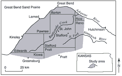
Location of major towns, county boundaries, and tributaries on the Great Bend Sand Prairie.
Kansas Geological Survey, Public Outreach Section
Placed online July 27, 1998
Comments to webadmin@kgs.ku.edu
The URL is HTTP://www.kgs.ku.edu/Publications/Books/1998/Arbogast/index.html