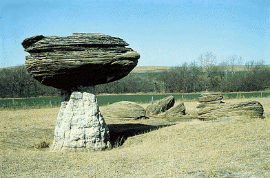
The Smoky Hills change from east to west. The eastern hills are capped with sandstone. This means the top layer of rock is sandstone with other layers, or beds, of rock underneath. The sandstone was formed from sediment carried by rivers into the shallow seas from the east. Mushroom Rocks, in Ellsworth County in central Kansas, are concretions of Dakota Formation sandstone, originally deposited during the Cretaceous Period, about 100 million years ago.
The hills in the middle are capped with limestone. This area of the Smoky Hills is known as post-rock country. Because wood was scarce, early farmers quarried limestone to use as fence posts. Although most of the newer posts are made of steel or wood, limestone fence posts can still be seen along many roads in the area. Limestone and sandstone in the Smoky Hills also are used for building.
Limestone in the Smoky Hills was formed from deposits in fairly shallow areas of the Cretaceous sea. Fossils of seashells and even sharks' teeth are frequently found in this area.
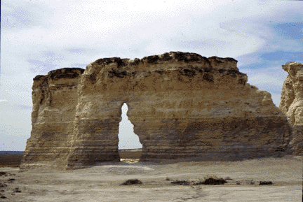
When the seas dried up in the western part of the Smoky Hills region, thick layers of sediment were left behind. The sediment was later buried between 1,000 and 2,000 feet underground and formed into chalk. Some areas of the chalk bed were later exposed by erosion. Today, much of the chalk at the surface has been eroded away by water. In some areas, tall, steep-sided chalk formations were left standing after the surrounding chalk eroded away. In Gove County, the Smoky Hill River carved out a large formation called Castle Rock and a series of formations called Monument Rocks. Chalk bluffs also can be found along the Smoky Hill River in Logan, Trego, and Gove counties.
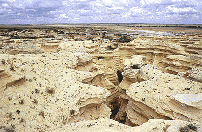
Wildcat Canyon in western Trego County is an extensive exposure of chalk that is part of the Niobara Formation. Deposited about 80 million years ago during the Cretaceous Period, these chalky shales are an excellent source of fossilized sharks, fish, turtles, mosasaurs, pterosaurs and other marine vertebrates that lived in the Cretaceous sea.
Kansas Geological Survey
Updated March 14, 1997
Send comments to webadmin@kgs.ku.edu
The URL for this page is http://www.kgs.ku.edu/Physio/smokyhil.html