Today the sea level is lower than during the Pennsylvanian and Permian periods and land in the area has been uplifted, or raised, by changes in the Earth. Lower sea levels and higher land caused the seas to retreat. The rocks formed from sediment deposited by the seas were then buried several thousand feet. Uplift and erosion have now exposed these rocks and formed hills, called cuestas.
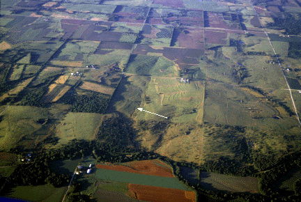
Cuestas have a steep slope on one side (an escarpment, the arrow in the photo below points to an escarpment) and gentler slopes on the other sides. Cuesta is the Spanish word for cliff.
The Osage Cuestas are composed of several alternating layers of sandstone, limestone, and shale. Not all of the hills in the Osage Cuesta region are cuestas with escarpments. Rolling hills and flat areas also can be found. Like all regions in the state, the cuesta region has variety.
Kansas Geological Survey
Updated March 14, 1997
Send comments to webadmin@kgs.ku.edu
The URL for this page is http://www.kgs.ku.edu/Physio/osage.html