This region was once crossed by many rivers. When the Rocky Mountains were forming millions of years ago, sediment such as sand and gravel was carried in by the rivers from the mountains. Some of the loose sand and gravel was naturally cemented to form a porous and permeable rock called mortarbed. Porous means it contains holes and permeable means the holes are interconnecting so that water can seep through. However, not all of the sand and gravel was compacted or cemented. Layers of tightly packed, but uncemented, sand and gravel are found in the subsurface in western Kansas. This layer of sand, gravel, and porous rock is known as the Ogallala Formation.
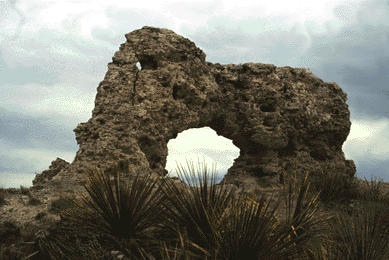
Most of the Ogallala Formation is underground, but in some places the porous rock crops out. Elephant Rock in Decatur County is an outcrop of the Ogallala Formation. Other good examples of Ogallala outcrops can be found in the bluff area around Scott County State Lake.
When it rains in the High Plains, water seeps into the ground and is stored in the Ogallala Formation. Since the region doesn't get much rainfall, people in the area have to rely on this ground water for their water supply. Much of the water in eastern Kansas is taken directly from rivers, but in western Kansas it is often necessary to dig water wells. The ground water also is used by farmers to irrigate their crops.
People originally thought the water from the Ogallala Formation would last forever and pumped water out to be used by cities, industries, and crop irrigation. Geologists began monitoring wells in the area and have recorded fairly steady water-level declines in the Ogallala over the past 20 to 30 years. The sparse rain in the area hasn't replaced the water as fast as people have pumped it. Now we know that if it isn't used carefully, much of the water could be exhausted.
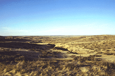
The Arikaree Breaks are an area of highly eroded canyons in the hills of Cheyenne County in extreme northwestern Kansas.
Kansas Geological Survey
Updated March 14, 1997
Send comments to webadmin@kgs.ku.edu
The URL for this page is http://www.kgs.ku.edu/Physio/highplan.html