


Physiographic Map--Glaciated Region
Several glaciers, which are huge masses of ice, covered much of the northern
United States hundreds of thousands of years ago. The glaciers grew and
melted as the climate changed. Most of the glaciers did not reach Kansas, but
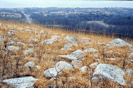
at least two dipped down into the northeast corner. When the glaciers
retreated, rocks and soil that had been carried into the area from the north
were left behind. The force of the moving ice was so strong, it broke large
quartzite boulders off outcrops in South Dakota, Iowa, and Minnesota and
carried them over 200 miles into Kansas. The boulders can still be seen
scattered throughout the area today.
The glaciers also left behind a layer of sediment. Finely ground silt, called
loess, was sorted and carried by the wind. Thick layers of loess were
deposited throughout the area. Fertile soils formed from loess are good for
farming because they contain few rocks.


Kansas Geological Survey
Updated March 14, 1997
Send comments to webadmin@kgs.ku.edu
The URL for this page is http://www.kgs.ku.edu/Physio/glaciate.html