In the late 1800's and early 1900's, business was booming in southeast Kansas. Growth was based on thriving industries, such as coal mining and the cement, glass, brick, and tile plants that popped up around the area. All of these industries used the natural resources such as coal, zinc, clay, and limestone. But by the 1930's, many of the industries closed because they were no longer profitable. Some industry still exists in southeast Kansas and coal is still mined, but the mineral-based industrial heyday is over.
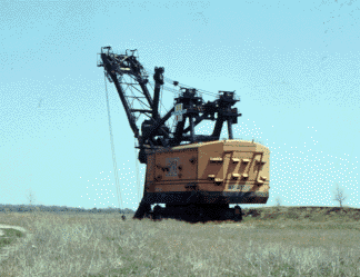
In Kansas, coal is removed by strip mining. Large, mechanical shovels are used to dig long, deep ditches to reach the underground coal. One of the world's largest shovels, Big Brutus, was used in Cherokee County. Big Brutus is retired from mining now and is used as a museum.
Companies must smooth out these ditches and plant trees and grass when they are finished mining. This is called land reclamation. After the land is leveled, it can be used for other things, such as farming and grazing.
Before 1969, companies didn't have to reclaim the land. Land that was not reclaimed can still be seen. Many of the abandoned ditches are now filled with water and have been stocked with fish.
Kansas Geological Survey
Updated March 14, 1997
Send comments to webadmin@kgs.ku.edu
The URL for this page is http://www.kgs.ku.edu/Physio/cherokee.html