Introduction
The Need for A Digital Petroleum
Atlas
The United States obtained 85 percent of its energy from fossil
fuels in 1995, nearly 40 percent from oil alone (of which half
was imported), and 24 percent from natural gas (President’s
Committee of Advisors on Science and Technology, 1997). U.S. fossil
fuel dependence, like that of the rest of the world, will decline
only slowly in the future. It has been estimated that fossil fuels
will provide two-thirds of all world energy needs in 2030 and
half or more in 2100 (EIA, 1997). U.S. oil imports, according
to the "reference" forecast of the Department of Energy,
would grow from 9 million barrels per day in 1995 to 14 million
barrels per day in 2015 and continue to increase for some time
thereafter. The Digital Petroleum Atlas program addresses many
of the issues of insuring a secure U.S. oil and gas supply as
outlined by the report of the President’s Committee of Advisors
on Science and Technology (1997).
The US and the Northern Mid-continent have large remaining
oil and particularly gas resources in numerous reservoirs. A higher
percentage of original oil and gas in place can be produced if
old and new data and knowledge are made available to operators.
Basic data and innovative developments in technology need to be
directly accessible to assist operators in day-to-day decisions.
The Kansas Geological Survey continues to work with the U. S.
Department of Energy and oil and gas producers to create a Digital
Petroleum Atlas (DPA) to meet these information needs. The DPA
is unique in that it provides independent operators on-line digital
and hard copy information, digital data bases, new cutting-edge
scientific study of typical fields of the region and purposeful
technology transfer. The atlas also provides to independent operators
an evaluation of the technologies that are best suited for additional
oil and gas recovery. Information is available when and where
operators need it (literally on the operator's desk).
During the past few years, the United States economy has performed
beyond most expectations. A shrinking budget deficit, low interest
rates, a stable macroeconomic environment, expanding international
trade with fewer barriers, and effective private sector management
are all credited with playing a role in this healthy economic
performance. Many observers believe advances in information technology
(IT), driven by the growth of the Internet, have also contributed
to creating this healthier-than-expected economy. In recent testimony
to Congress, Federal Reserve Board Chairman Alan Greenspan noted,
"...our nation has been experiencing a higher growth rate
of productivity—output per hour—worked in recent years.
The dramatic improvements in computing power and communication
and information technology appear to have been a major force behind
this beneficial trend." The Digital Petroleum Atlas is one
attempt to bring these advances in information technology to the
independent oil and gas operator.
The DPA will provide a tool to enhance Kansas oil and gas production.
The demonstration of the digital petroleum atlas will also enable
similar projects to be instituted in other petroleum producing
areas, so that a geographically broad on-line digital database
will be available to domestic operators. The ultimate goal is
a national digital petroleum atlas.
Short of conducting a full-scale reservoir analysis of each
producing field, an efficient and effective method of communicating
key information to operators is by example. For each reservoir
type in a producing region, a thoroughly studied and documented
analog can illustrate geologic and engineering procedures that
are likely to be most successful in increasing ultimate recovery.
An analog example provides operators with sufficient information
and procedures to study producing fields, and increase production
and ultimate recovery by modifying and applying proven methods.
One way to accomplish the goal of disseminating information by
analog is to provide a digital on-line geological and engineering
based, state-of-the-art, petroleum atlas that contains not only
historical data and descriptions, but technologically advanced
syntheses and analyses of "why reservoirs produce" and
"how ultimate production may be increased." This is
a national need. A digital petroleum atlas is an efficient and
effective vehicle to provide access to legacy databases and innovative
knowledge that can be used by the operator.
The traditional role of technical publication is to formalize
and record scientific and technical results in time, and to transfer
technology to potential users (Kerkhof, 1994). The published petroleum
atlas is a time-honored approach to illustrating by analog the
latest petroleum exploration and development knowledge and application
(e.g., Powers, 1929; Galloway, et al., 1983; Bebout, et al., 1993,).
Similar proprietary compilations are common at major petroleum
companies. The underlying goals of these petroleum atlases have
been to:
- Synthesize information on major reservoirs, fields, plays
and basins
- Assist in efficient exploration and development by increasing
technical knowledge of trapping, discovery and production of
oil and gas;
- Serve as analogs for reservoirs, fields and plays similar
to those described; and
- Provide an overview and introduction to the various petroleum
basins described.
The traditional published atlas is a time consuming and expensive
process that results in static paper product. Typically, products
and data are limited by space and cost considerations to summary
information at the field or reservoir level. For each play, field
or reservoir only a relatively small number of author-selected
maps, cross-sections, charts and other summary data are included.
Typically, the paper atlas does not provide access to well and
lease data or to intermediate research products (such as digital
geographic and geologic components of maps, interpreted and uninterpreted
subsurface data, well test analyses, thin section images, and
other traditionally unpublished material). Without access to the
data and intermediate products, modifying and updating a published
field study to fit a user-defined application or new scientific
idea is a difficult and time consuming process.
Today, traditional channels of scientific and technical communication
represented by the petroleum atlas are being challenged by the
shear volume of publication, the increased unit costs, the relatively
decreased resources of academic and industrial library systems,
and the rapidity of technical change (Okerson,1992). In addition,
the growth of networks, storage servers, printers, and software
that make up the Internet are rapidly changing the world from
one in which research organizations, publishers and libraries
control the printing, distribution, and archiving to a world in
which individuals can rapidly and cheaply "publish",
provide access and modify scientific results on-line. These changes
offer significant challenges and opportunities both to public
and private sector participants and to the traditions of technical
publication (Denning and Rous, 1995).
Kansas Petroleum Atlas
The Kansas Digital Petroleum Atlas (DPA) is an on-line publication
available on the Internet anywhere in the world using a standard
point-and-click world-wide-web interface (Figure
1). The Uniform resource locator (URL) is http://www.kgs.ku.edu/DPA/
dpaHome.html. The DPA consists of studies at reservoir, field,
play and basin scales. The DPA is a dynamic, evolving product
with new structure, research results, and data appearing almost
daily. Through complete and flexible user access to technology,
interpretative products, and underlying geologic and petroleum
data, the DPA 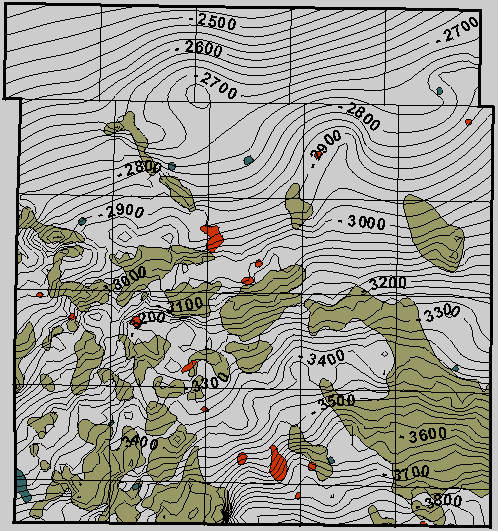 alters the relationship between interpretative
result and data, between technology generation and application.
At the present time, the Digital Petroleum Atlas currently contains
over 6,000 static web pages covering 8 counties, 7 fields and
two regions of Kansas. "Static" pages are actual HTML
text files on the DPA web server showing information to visitors.
Most of DPA pages are very similar--that is, a template can be
made and multiple pages extracted from that template. For example,
for a set of county geology pages (Figure
2), the only differences are the names of the files, the window
titles, and the two figures (i.e., map and stratigraphic chart).
The navigation is adjusted for each page (assigning a "Previous"
page and assigning a "Next" page). As a result, a new
set of geologic maps, core photos, etc., for a new play or field
can be integrated into the DPA efficiently as a new set of static
web pages. In addition, web access is provided to programs that
can query relational database systems containing production, well
and electric log data. The pages cover Kansas’s oil and gas
plays at scales from the regional through the single well sample.
It also consists of a navigational architecture that permits accessing
the DPA information by a number of methods.
alters the relationship between interpretative
result and data, between technology generation and application.
At the present time, the Digital Petroleum Atlas currently contains
over 6,000 static web pages covering 8 counties, 7 fields and
two regions of Kansas. "Static" pages are actual HTML
text files on the DPA web server showing information to visitors.
Most of DPA pages are very similar--that is, a template can be
made and multiple pages extracted from that template. For example,
for a set of county geology pages (Figure
2), the only differences are the names of the files, the window
titles, and the two figures (i.e., map and stratigraphic chart).
The navigation is adjusted for each page (assigning a "Previous"
page and assigning a "Next" page). As a result, a new
set of geologic maps, core photos, etc., for a new play or field
can be integrated into the DPA efficiently as a new set of static
web pages. In addition, web access is provided to programs that
can query relational database systems containing production, well
and electric log data. The pages cover Kansas’s oil and gas
plays at scales from the regional through the single well sample.
It also consists of a navigational architecture that permits accessing
the DPA information by a number of methods.
Usage of the Prototype Digital
Petroleum Atlas
Since the Digital Petroleum Atlas is an electronic publication,
on-line access was provided to the public soon after project inception
(January 1996). Use of the DPA products was almost immediate and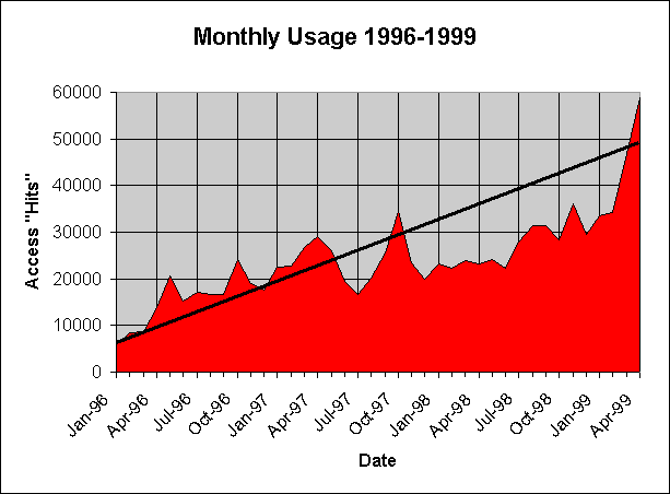 has grown steadily over the last three plus years (Figure
3). This near real-time transfer of technology and information
to the client is one advantage clearly demonstrated by the DPA.
has grown steadily over the last three plus years (Figure
3). This near real-time transfer of technology and information
to the client is one advantage clearly demonstrated by the DPA.
The pages that comprise the DPA make up the bulk of the web
site for the Petroleum Research Section (PRS) of the Kansas Geological
Survey. Usage statistics show that access to these pages has grown
to over 50,000 access "hits" per month (Figure
3). In measuring access "hits" on the PRS site,
all access to graphics is removed. This eliminates the multiple
counting of access hits that result from multiple figures (buttons,
bars, arrows, etc.) on a single web page. In addition, all access
from the Kansas Geological Survey subdomain (kgs.ku.edu) is
removed. This measurement protocol produces a consistent and conservative
measure of external usage. Current usage statistics are collected
daily and weekly and are available on the Petroleum Research Section
of the Kansas Geological Survey web site (http://www.kgs.ku.edu/usage/past_stats.html).
Each month a detailed usage report is generated for the oil
and gas portion of the Kansas Geological Survey web site. The
latest report for April 1999 (http://www.kgs.ku.edu/usage/1999/apr_wt/default.htm)
provides rough quantitative measures for the Digital Petroleum
Atlas. In April, the pages of the Digital Petroleum ranked among
the most requested pages (Figure 4).
Other highly requested pages on the Petroleum Research web server
are portals that provide general access to the Digital Petroleum
Atlas and other oil and gas information. After the user enters
the Digital Petroleum Atlas Home Page or DPA-Kansas Page they
split off in any number of directions. The Digital Petroleum Atlas
HomePage was also the number 3 most popular entry page and the
number 5 most popular exit page. This is interpreted to mean that
the DPA is bookmarked and users jump directly to it. The April
statistics also show that the Petroleum Research Web Site and
the Digital Petroleum Atlas appealed primarily to companies (.com
domain with 72.54% of total hits and 3904 separate sessions last
month) and networks (.net domain with 20.02% of total hits and
1279 separate). The .net domain is interpreted as representing
the very small independent and consultant who uses a local or
national Internet access provider. Statistics for April 1999 measure
the most accessed directories on the Petroleum Research web server.
The DPA is the most accessed directory with over a third of the
total hits for the site (Figure 5).
Other measures of the impact of the Kansas Digital Petroleum
Atlas are unsolicited comments and success stories received by
users. A selection of comments and a success story are provided
in Appendix A.
This page maintained by the
Kansas Geological Survey.
Updated June 1999
Comments to webadmin@kgs.ku.edu
URL=http://www.kgs.ku.edu/PRS/publication/99_19/9919intro.html