Kansas Geological Survey, Open File Report 96-50
Figure 5a--Single well, lower resolution seismic model. Colors represent seismic amplitude. Vertical scale in seconds of two-way travel time from the top of the model. Abbreviations same as Figure 4a. A black and white verion of this plot is available.
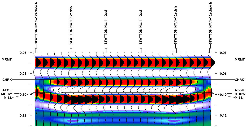
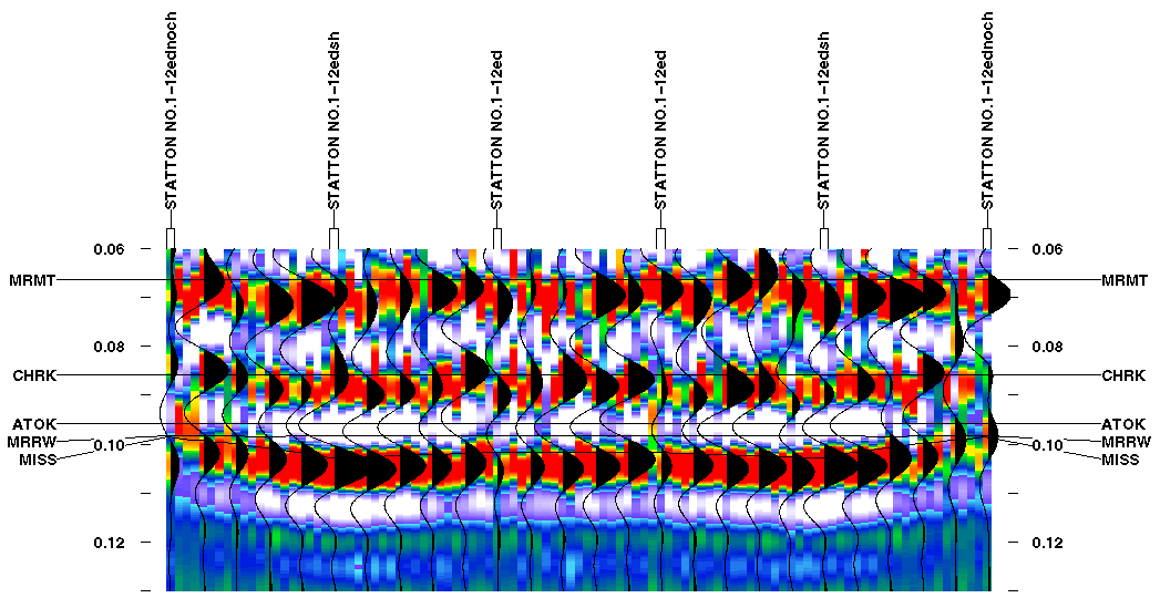
Figure 5b--Same as Figure 5a with random noise added. A black and white verion of this plot is available.
Surprisingly enough, the model also indicates that although the Mississippian peak is of higher amplitude in the channel than on the flanks, the amplitude is lower where the 9 ft. (2.7 m.) Morrow sandstone present compared to the section where shale replaces the sandstone (Fig. 5a). This increase in amplitude towards the shale filled interval is due to the replacement of the sand with the lower velocity shale (Fig. 4a). This causes overall greater average impedance contrasts at the top and base of the channel interval over the dominant wavelength of the wavelet, and thus a greater amplitude to the trough and peak associated with these impedance contrasts. In addition, to the increase in amplitude observed between the sandstone and shale section, a slight thickening of the isochron interval occurs between the extra Cherokee peak and the Mississippian peak(Fig. 5a). This subtle isochron anomaly is due to the lower velocity shale Morrow-Mississippian interval compared to the higher velocity sand which replaces some of the sand in the interval (Fig. 4a).
As expected, adding 10% random noise to the seismic model make the anomalies associated with the channel fill more difficult to interpret (Fig. 5b). Anomalies 1-3 mentioned above are all compromised but to differing degrees. The isochron anomaly between the Marmaton and Mississippian peaks is still noticeable over the channel. However, the development of the extra peak and the increase in amplitude as the channel fill thickens is less noticeable. It is possible that if the no channel ends of the model were extended laterally that the changes might be more noticeable. The ability of previous workers to identify the channel on existing seismic data with bandwidths similar to the one used in this model suggests that the random noise levels on the seismic data are not much worse than 10% or that the channels being identified are not much thinner than 21 ft. (6.4 m.). In addition to the difficulties in identifying the channel on the model with noise, it is also much more difficult to see the amplitude and isochron differences between the shale filled Morrow-Mississippian interval and the one that contains the sandstone.