Kansas Geological Survey, Open File Report 96-49
Line D2 is perpendicular to line D1 and hence approximately follows, or is highly oblique to, the strike of the cross-bedded oolitic limestones (Figs. 2 and 6). Line D2 is also perpendicular to the highwall outcrop so reflectivity can only be tied to the outcrop via the intersection with line D1. However, this line enhances the outcrop information by adding a third dimension to the outcrop face.
Figure 6a--Uninterpreted version of GPR line D2. This line is primarily a strick line with respect to cross-bedding, and is perpendicular to both line D1 and the highwall outcrop (Fig. 2). Station locations (ft) are indicated along the bottom of the section as well as by vertical lines on the GPR data every five stations. CDP locations which indicate the trace number are indicated along the top of the section. The profile is an unmigrated time section with the vertical scale in nanoseconds. An approximate depth scale is indicated which assumes a velocity of 0.12 m/ns. An approximate horizontal scale is also indicated which assumes a constant trace spacing of 3 cm/trace. A large version is also available. The large version is 600k and will take some time to download!.
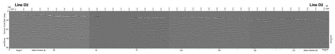
Figure 6b--Interpreted version of line D2. Major reflections which are correlated with the major horizons or bounding surfaces on the photomosaic are indicated by thicker lines and labels. Other prominent reflections are indicated by thinner lines and do not necessarily correlate with the bed boundaries interpreted on the photomosaic. A large version is also available. The large version is 600k and will take some time to download!.
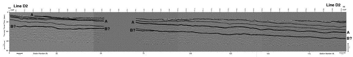
The only horizon on line D2 which can be correlated to line D1 with any degree of confidence is horizon A. On line D2, like on line D1, horizon A and the cross-bedded layers above it are moderately to highly reflective. Apparent dip of horizon A is to the southeast along line D2, but the reflections above it alternate in apparent dip from gently southeast, to northwest, then back to the southeast between stations 100 and 195 (Fig. 6). These reflections also downlap onto horizon A between stations 15 and 50 (Fig. 6). The dip of the reflections above horizon A are probably due to the highly oblique N 30 degrees W orientation of line D2 with respect to the N 25 degrees W strike of the cross-beds measured at the surface. The dip of horizon A may not be explained as easily. Part of the apparent southeast dip may be due to a slightly greater east-west trend to the center of the channel-like form then the trend of line D2. This would put the center of the trough closer to line D2 near station 200 than it is near station 0. However, horizon A is more than 1 m below the surface at the southeast end of line D2 (Fig. 6), whereas it is less than 1 m deep at its maximum along line D2 (Fig. 5). This geometry requires some component of southeast dip to horizon A.
Reflections below horizon A also have apparent dips to the southeast and in some cases (e.g. stations 15-35) are truncated by horizon A (Fig. 6). These reflection terminations, along with the ones on line D1 (Fig. 5), support the erosional nature of horizon A and suggest that it may be a channel or depositional low between oolite bodies or delta lobes. Like the reflections above horizon A, the apparent southeast dip of the reflections below horizon A may also be explained by the oblique orientation of line D2 with respect to a more northerly orientation of the average strike of cross-beds below horizon A. At least one interpreted reflection below horizon A appears to downlap onto another gentler dipping interpreted reflection between stations 80 and 85. The lower more gently dipping reflection may correlate with horizon B on line D1 (Figs. 5 and 6). However, due to the poor data quality and a covered outcrop along horizon B northeast of station 35 on line D1, the correlation is not certain. For this correlation to occur, the apparent northeast dip of horizon B on line D1 would have to reverse between stations 0 and 35, allowing horizon B to intersect station 0 a little more than 1 m below the surface (Fig. 5).