


Kansas Geological Survey, Open File Report 96-49
GPR Study of The Drum Limestone, Figure 2
Please use the "Back" command of your browser to return to the page
you were viewing.
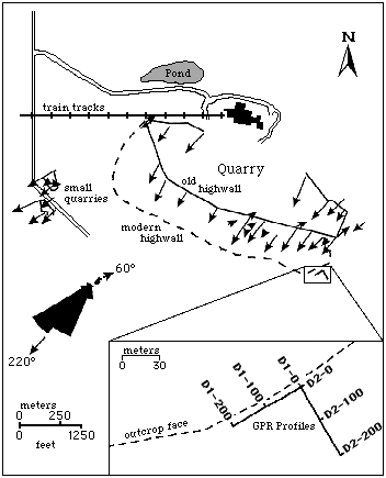
Figure 2--Map of the Heartland Cement quarry
showing highwall locations, cross-bedding dip directions, and
location of GPR lines D1 and D2 with respect to the modern
highwall (modified from
Feldman et al., 1993).
Stations 0, 100, and 200 are also indicated along the GPR lines
in the detailed map.
Please use the "Back" command of your browser to return to the page
you were viewing.
Report Contents
Kansas Geological Survey, Open-File Report 96-49
Placed online Jan. 1997
Comments to webadmin@kgs.ku.edu
URL=http://www.kgs.ku.edu/PRS/publication/OFR96_49/fig2.html