Depositional Setting
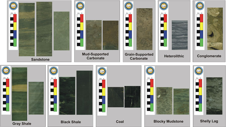
Depositional setting is a key control of coal distribution, thickness, and coal quality. A continuous core from Wilson County was used to collect coal samples and to help identify lithotypes within the study area. The core was described and broken into 10 lithofacies. Interpretations into processes and environments were made. A variety of depositional settings were determined, ranging from subaerial exposure to deep-water environments. The distribution and occurrence of lithofacies within the Cherokee and Marmaton groups indicates cyclic fluctuations in relative sea level. The following table outlines the facies, processes, and environments found in the Cherokee and Marmaton groups in the study area.
| Facies | Process | Environment |
|---|---|---|
Sandstone |
Tidal currents |
Estuary |
Mud-Supported Carbonate |
Low Energy accumulation of carbonate mud and bioclasts |
Open Marine (below fair |
Grain-Supported Carbonate |
Higher energy reworking of carbonate material by waves and tides |
Marine (above fair weather wave base) |
Heterolithic |
Low-energy tidal and sediment fallout |
Lagoon or Estuary |
Conglomerate |
Exposure and reworked parent rock |
Contintal Transgression |
Gray Shale |
Sediment fallout |
Offshore |
Black Shale |
Sediment fallout |
Offshore (anoxic conditions) |
Coal |
Peat accumulation |
Mire |
Blocky Mudstone |
Pedogenesis |
Subareal Exposure, Paleosol |
Shelly Lag |
Transgressive reworking |
Transgressive surface |
http://www.kgs.ku.edu/PRS/publication/2006/2006-13/p1-04.html
Last Modified May 2006