Kansas Geological Survey, Open-file Report 2004-56
by
Susan E. Nissen1, Kurt J. Marfurt2 and Timothy R. Carr1
1 Kansas Geological Survey, University of Kansas
2 Allied Geophysical Laboratories, University of Houston
KGS Open File Report 2004-56
The widespread Western Interior Plains (WIP) aquifer system has a high potential for sequestration of large quantities of CO2 in a deep saline aquifer, with the addition of value-added sequestration through enhanced oil recovery. In Kansas, the Mississippian aquifer unit of the WIP consists primarily of naturally fractured, solution-enhanced, multi-layered shallow shelf carbonates with a strong bottom water drive. On both regional and local scale, fluid flow in the Mississippian aquifer is strongly influenced by fracturing. Fractures can either be open, providing a water conduit, or shale-filled, providing a barrier to fluid flow.
New 3-D seismic attributes, including a suite of volumetric reflector curvature attributes developed at the University of Houston, have the potential to reveal subtle lineaments that can be related to fractures in the aquifer. Volumetric curvature attributes are calculated directly from a seismic data volume, with no prior interpretation required, and have been shown to be useful in delineating faults, fractures, flexures, and folds.
Volumetric curvature attributes applied to a 3-D seismic survey over the Mississippian aquifer in Kansas reveal two main lineament directions within the Mississippian, with orientations of approximately N45E and N45W. The N45E-trending lineaments parallel a down-to-the-north normal fault at the northwestern corner of the seismic survey, and appear, on average, to have greater length and continuity than the N45W-trending lineaments. Geologic and production data suggest that the N45E-trending lineaments may be related to shale-filled fractures, while the N45W-trending lineaments may be related to open fractures that are conduits for water. Both sets of lineaments are related to karst-enhanced fracturing in the Mississippian.
Imaging of natural fractures within an aquifer system to be used for CO2 sequestration is required to maximize injection and storage of CO2 and minimize early breakthrough between wells. Also, detection of fractures is critical to evaluating the integrity of overlying seal. New 3-D seismic attributes help to locate these fractures and could become an important tool in the evaluation of potential geological sequestration sites.
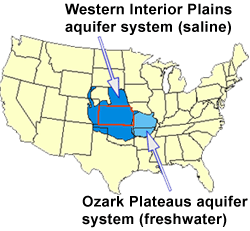
The Lower Paleozoic Ozark Plateau aquifer system is a widespread regional-scale aquifer system which extends over portions of 9 states (Figure 1). The freshwater component of the system, located primarily in Missouri and Arkansas, is known as the Ozark Plateaus (OP) aquifer system, while the saline component is referred to as the Western Interior Plains (WIP) aquifer system. The saline WIP aquifer system is a potential site for sequestration of large quantities of CO2.
Figure 1--Regional Extent of the Ozark Plateau aquifer system. Boundries of the Western Interior Plains and Ozark Plateaus aquifer systems modified from Jorgensen et al. (1993).
A generalized stratigraphic section for Kansas (Figure 2) shows that the Ozark Plateau aquifer system is divided into a lower unit of Cambrian sandstone and Cambro-Ordovician carbonates and an upper unit of Mississippian carbonates, separated by a confining unit of low permeability carbonates and shales.
Figure 2--Generalized stratigraphy of Kansas, modified from Merriam (1963), Jorgensen et al. (1993), Cansler and Carr (2001).
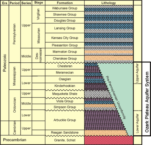
The present study focuses on the upper (Mississippian) aquifer unit. In Kansas, this unit is composed primarily of naturally fractured, multi-layered shallow shelf carbonates of Chesterian, Meramecian, and Osagian age. The aquifer is unconformably overlain by Pennsylvanian shales of the Cherokee Group, which serve as a confining unit for the aquifer. The top of the Mississippian aquifer unit was subaerially exposed prior to the Pennsylvanian and has been modified by extensive karst, which resulted in solution-enhancement of the fractures. Fluid flow in the aquifer is strongly influenced by fracturing. The Mississippian aquifer unit is immediately underlain by low porosity and permeability Kinderhookian carbonates.
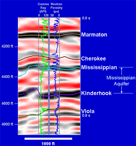
An example seismic section from Dickman Field, Ness County, KS (Figure 3), shows that the top and base of the Mississippian aquifer can be imaged seismically. The top of the aquifer is a positive seismic reflection (black), corresponding to the boundary between Cherokee shales and Mississippian dolomite seen on the gamma ray log. The base of the aquifer is also a positive seismic reflection, corresponding to the boundary between porous (18% porosity) Mississippian dolomite and tight (5% porosity) limestone of the Kinderhook Fm.
Figure 3--Seismic Section over Mississippian Aquifer
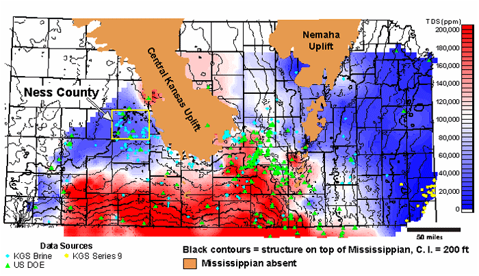
The Mississippian aquifer unit is present over most of Kansas, except where removed by subsequent erosion on the Central Kansas Uplift and Nemaha Uplift (Figure 4).
Figure 4--Mississippian Subcrop Map of Kansas.
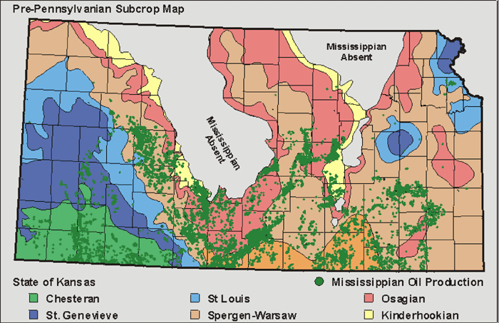
As can be seen by the green dots on Figure 4, the Mississippian aquifer unit in Kansas is associated with oil and gas reservoirs throughout the state. Approximately 1 billion barrels of oil have been produced from the Mississippian in Kansas, accounting for approximately 19% of total Kansas oil production and 33% of Kansas production for the past 10 years. Most of the Mississippian reservoirs are super-mature, but considerable amounts of petroleum remain to be produced using enhanced recovery techniques, such as CO2 flooding. Depleted petroleum reservoirs are expected to be good candidates for CO2 sequestration because of their proven seal integrity.
Wells drilled into the Mississippian for hydrocarbon exploration and production have provided a large amount of data on the thickness, porosity, temperature, pressure, and salinity of the Mississippian aquifer unit. All of these measurements are parameters that can be used in estimating CO2 sequestration potential. These data can be mapped regionally, as is exemplified by the total dissolved solids (TDS) map for the state of Kansas (Figure 5), constructed from 782 brine samples. Various parameters can be combined to estimate the regional CO2 sequestration potential. Preliminary calculations suggest that hundreds of millions of metric tons of CO2 could be stored in the Mississippian aquifer unit in Kansas.
Figure 5--Total Dissolved Solids in Mississippian Brines.
Numerous 3-D seismic surveys have been acquired over petroleum-producing areas of the Mississippian aquifer. The seismic data provide local information which can help evaluate potential CO2 sequestration sites. An example of the value-added information provided by 3-D seismic data will be shown for a study area in Ness County, KS.
Figure 6 shows an enlargement of Figure 5 for Ness County, with the structure of the top of Mississippian superimposed. Blue lineaments have been interpreted from a dip map of the top of Mississippian structure (Figure 7). These blue lineaments show a regional structural fabric dominated by northeasterly and northwesterly trends. At several locations, the lineaments correspond to boundaries between regions of higher and lower salinity on the TDS map, suggesting that the structural lineaments can serve as boundaries to fluid flow in the aquifer.
Figure 6--Total Dissolved Solids in Mississippian Brines, Ness County, Kansas. TDS data points are shown by blue diamonds and green triangles. Oil fields are shown in dark green.
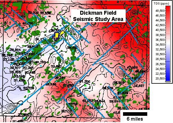
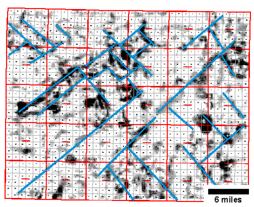
Figure 7--Dip map of the top of Mississippian surface for Ness County. Lineaments with high dip are likely to indicate faults. Interpreted lineaments are shown in blue.
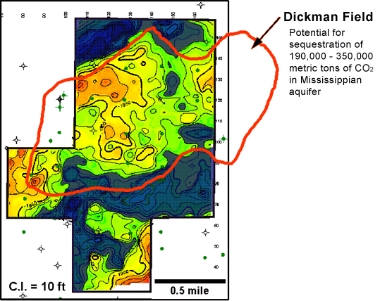
The location of a 2 square mile 3-D seismic survey over Dickman Field, a Mississippian oil reservoir, is shown by the yellow polygon on Figure 6.
Approximately 1.7 million barrels of oil have been produced from Dickman Field. Preliminary calculations predict that this reservoir has the potential to sequester approximately 190,000 metric tons of CO2 (based on the assumption that CO2 remains as a separate fluid phase and is stored by displacement of fluids) to 350,000 metric tons of CO2 (based on the assumption that CO2 dissolves in the brine). The calculators used to estimate CO2 sequestration are found at http://www.midcarb.org/calculators.shtml.
The seismic reflector corresponding to the top of the Mississippian aquifer has been interpreted across the Dickman 3-D seismic survey and has been used to construct a detailed map of the depth to the top of the Mississippian (Figure 8). This seismic depth map shows topographic detail that is not possible with well data alone and can be used to help refine estimates of the reservoir volume, and thus revise estimates of CO2 sequestration potential. The areas where the top of the Mississippian is beneath the oil-water contact are covered by the shaded overlay in Figure 8.
Figure 8--Seismic Depth Map of Top of Mississippian for Dickman Field.
The northwest edge of Dickman Field corresponds to a down-to-the-north northeast-trending normal fault, which was seen as a lineament on the top of Mississippian dip map for Ness County (Figure 7). The Ness County map, constructed from well data alone, did not show any other structural lineaments in Dickman Field. The Dickman 3-D seismic data, however, has the potential to provide more structural detail. Effectively locating fractures is of particular interest, since fluid flow in the Mississippian aquifer is strongly influenced by fracturing.
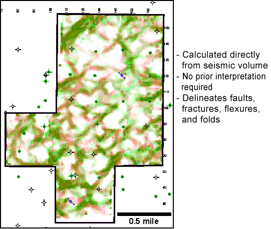
The volumetric reflector curvature attribute shown in Figure 9 can reveal lineaments related to subtle faulting and fracturing (Sullivan et al., 2004). Maps of volumetric curvature extracted from the top and base of the Mississippian aquifer are superimposed to identify the vertical continuity of lineaments, as well as highlight any lineament offset with depth, which would indicate dip. Most of the lineaments appear to persist from the top to the base of the aquifer and are near vertical, although there does appears to be a consistent 65-70 degree northeasterly dip to the northwest-trending features in the northern portion of the survey.
Figure 9--Volumetric reflector curvature attribute (maximum negative curvature) extracted along top of Mississippian Aquifer (green) and Base of Mississippian Aquifer (red).
Lineaments have been interpreted on a volumetric curvature map extracted along the seismic horizon corresponding to the base of the Mississippian aquifer (Figure 10). Rose diagrams of the interpreted lineaments show that there are two main directions of lineaments -- northeast and northwest, similar to regional lineament directions defined for Ness County.
Figure 10--Left: Volumetric curvature extracted at the base of the Mississippian aquifer with interpreted lineaments in red. Right: Rose diagrams of the interpreted lineaments.
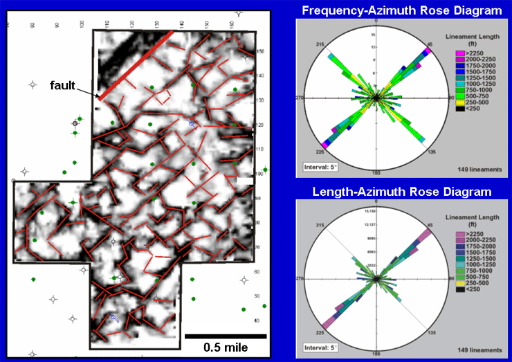
Although the number of lineaments interpreted with northeasterly and northwesterly trends is approximately equal (Figure 10, top right), northeast-trending lineaments have greater length and continuity than the northwest-trending lineaments (Figure 10, bottom right). The northeasterly lineament trend parallels the fault at the northwest corner of the seismic survey.
The next step in analyzing this data is to determine if any of the lineaments represent open fractures, which could serve as water conduits, or shale-filled fractures, which could be barriers to fluid flow.
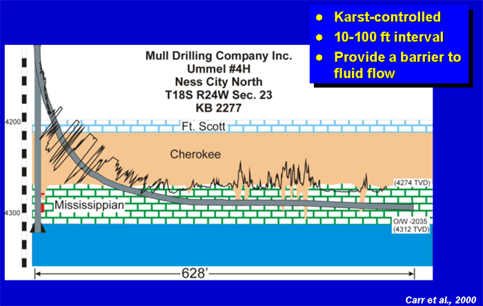
Evidence for the presence of shale-filled fractures at the top of the Mississippian is found in a horizontal well from central Ness County, approximately 8 miles from the Dickman Field study area. In this well, numerous near-vertical shale intervals have been identified along the lateral length of the well (Figure 11). These intervals have been interpreted as solution-enhanced fractures extending down from the karst surface at the top of Mississippian that have been filled by Pennsylvanian Cherokee Shale (Carr et al., 2000).
Figure 11--Shale-filled fractures intersected by a horizontal well in Ness County, Kansas.
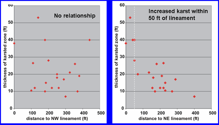
Since there are no horizontal wells in Dickman Field, indirect evidence must be used to infer the presence of shale-filled fractures. Since these fractures were solution-enhanced by karsting and are likely filled by both Pennsylvanian shale and weathered Mississippian debris, it is assumed that locations with evidence of a thicker section of weathered Mississippian material at the base of the Pennsylvanian (subsequently referred to as the "karsted zone") are related to shale-filled fractures. For the purposes of this study, the karsted zone in each well was defined as the interval between the highest occurrence of the basal chert conglomerate in the Pennsylvanian section (chert weathered from the Mississippian) to the top of the Mississippian.
In order to determine whether the shale-filled fractures are preferentially related to either the northeast- or northwest-trending lineaments (i.e., was one particular fracture direction open and preferentially solution-enhanced during karsting?), crossplots were created of the thickness of the karsted zone versus the distance to the nearest northeast- and northwest-trending lineaments (Figure 12). These crossplots show that there is no apparent relationship between the thickness of the karsted zone and the northwest-trending lineaments; however, there is an increase in the thickness of the karsted zone within approximately 50 ft of the northeast-trending lineaments. The relationship between the thickness of the karsted zone and distance to the northeast-trending lineament suggests that interpreted northeast-trending lineaments are likely to represent fractures which were preferentially solution-enhanced during karsting and are filled with Pennsylvanian shale. Since some of the northeast trending lineaments have interpreted lengths in excess of 0.5 mile, they may provide significant barriers to fluid flow in the northwest-southeast direction.
Figure 12--Thickness of karsted zone in well versus distance to nearest NW and NE lineaments.
The relationship between the interpreted lineaments and fluid flow can be investigated by examining the spatial variability of fluid production from the wells in Dickman Field and by comparing fluid production to lineament proximity.
The map on the left of Figure 13 shows with light green circles the amount of oil produced from the Mississippian during the first 12 months of production for each well in Dickman Field. The largest circle corresponds to approximately 25,000 Bbl. The interpreted lineaments are shown in red and the areas where the top of Mississippian is below the oil-water contact are shown in dark blue. There is no obvious spatial link between wells with high oil production, as compared to wells with low oil production.
Figure 13--Left: Bubble map of oil production from the Mississippian. Right: Oil production versus distance to nearest NW and NE lineaments.
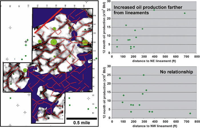
In order to evaluate whether there is a link between oil production and either northeast- or northwest-trending lineaments, oil production is crossplotted against the distance to the nearest northeast- and northwest-trending lineaments (Figure 13, right). The crossplots indicate that there is no identifiable relationship between oil production and the northwest-trending lineaments but there does appear to be an overall increase in oil production away from the northeast-trending lineaments. This suggests that in proximity to the northeast-trending lineaments there may be a higher concentration of shale-filled fractures that inhibit oil production.
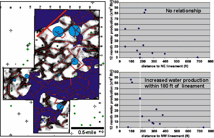
Water production from the wells in Dickman Field may be related to open fractures that extend into the underlying Mississippian aquifer. The blue circles on the lineament map at the left on Figure 14 show the amount of water produced from each well during the first 12 months of oil production. The largest circle corresponds to approximately 86,500 Bbl.
In order to evaluate whether open fractures are linked to either the northeast- or northwest-trending lineaments, water production is crossplotted against the distance to the nearest northeast- and northwest-trending lineaments (Figure 14, right). The crossplots indicate that there is no relationship between water production and the northeast-trending lineaments but there is increased water production within 180 ft of the northwest-trending lineaments. This indicates that the northwest-trending lineaments represent fractures which serve as conduits to the aquifer.
Figure 14--Left: Bubble map of water production from the Mississippian. Right: Water production versus distance to nearest NW and NE lineaments
Cansler, J. R., and Carr, T. R., 2001, Paleogeomorphology of the Sub-Pennsylvanian Unconformity of the Arbuckle Group (Cambrian-Lower Ordovician): Kansas Geological Survey, Open-file Report 2001-55. [available online]
Carr, T. R., Bhattacharya, S., and Pancake, R., 2000, Horizontal drilling in Kansas: A case history: presentation by Kansas Geological Survey and KU's Tertiary Oil Recovery Project at KIOGA Annual Convention [available online]
Gerlach, P., 1998, Pre-Pennsylvanian subcrop map: Kansas Geological Survey, Digital Petroleum Atlas. [available online]
Jorgensen, D. G., Helgesen, J. O., and Imes, J. L., 1993, Regional aquifers in Kansas, Nebraska, and parts of Arkansas, Colorado, Missouri, New Mexico, Oklahoma, South Dakota, Texas, and Wyoming--Geohydrologic framework: U.S> Geological Survey, Professional Paper 1414-B, 72 p. [available online]
Merriam, D.F., 1963, The geologic history of Kansas: Kansas Geological Survey, Bulletin, 162, 317 p. [available online]
Sullivan, E. C., Marfurt, K. J., and Blumentritt, C., 2004, Application of volumetric seismic attributes to fractured reservoirs: A potentially important technology for the Appalachian Basin: Geolgical Society of America, Northeastern Section (39th Annual) and Southeastern Section (53rd Annual) Joint Meeting, March 25-27, 2004, Washington, D.C.
Kansas Geological Survey, Energy Research
Last Modified December 2004
Comments to webadmin@kgs.ku.edu
The URL for this page is http://www.kgs.ku.edu/PRS/publication/2004/2004-56/index.html