
Southeast Kansas Coal Geology Field Trips
Open-file Report 2002-27
|
|
|
Kansas Geological Survey Open-file Report 2002-27 |
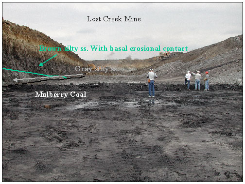
View looking north in coal pit at Lost Creek Mine operated
by Continental Coal Inc. Mine is located in Sec. 18, T23S, R24E,
Linn Co., KS. Coal mined is the Mulberry Coal of the Bandera Formation
(Marmaton Group). The Mulberry Coal is approximately 20-26”
thick. Production in 2000 was about 50,000 tons due start-up late
in the year. Production in 2001 is estimated at 160,000 tons.
View looking southwest in coal pit at Lost Creek Mine operated by Continental Coal Inc. Mine is located in Sec. 18, T23S, R24E, Linn Co., KS. Coal mined is the Mulberry Coal of the Bandera Formation (Marmaton Group). The Mulberry Coal is approximately 20-26” thick. Production in 2000 was about 50,000 tons due start-up late in the year. Production in 2001 is estimated at 160,000 tons.
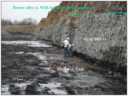
Mulberry coal is at base and overlain by a gray slity sandstone.
The gray silty sand stone is overlain by a brownish silty sandstone
that appears to be cutting down into the underlying silty sandstone.
Contact is erosional and is marked by an erosional lag of carbonate
material and some coal fragments.
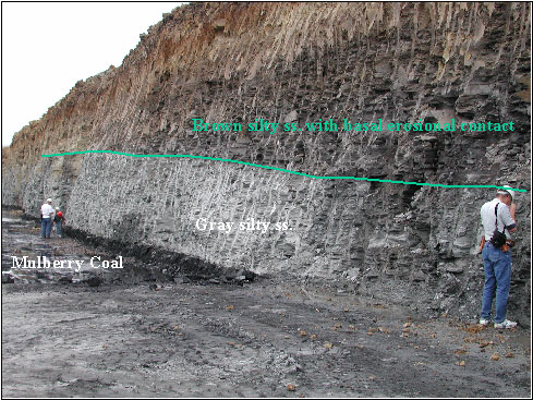
View of north wall of coal pit at Lost Creek Mine. Mulberry coal is at base and overlain by a gray slity sandstone. The gray silty sand stone is overlain by a brownish silty sandstone that appears to be cutting down into the underlying silty sandstone. Contact is erosional and is marked by an erosional lag of carbonate material and some coal fragments.
|
|
e-mail
: webadmin@kgs.ku.edu
Last updated June 2002
http://www.kgs.ku.edu/PRS/publication/2002/ofr27/P1-04.html