
Midcontinent Interactive Digital Carbon Atlas and
Relational Database (MIDCARB)
Kansas Geological Survey
Open-file Report 2002-7
|
|
|
Kansas Geological Survey Open-file Report 2002-7 |
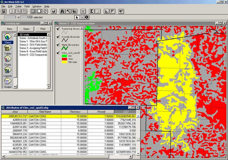
In Ohio tools are being developed as part of the MIDCARB project to calculate the amount of CO2 sequestration in oil and gas fields using geographic information systems (GIS) technology. This will be integrated with the Internet map server and used as a template for the other consortium states. In this example, the Clinton sandstone oil and gas pools GIS layer are displayed, along with some of the attributes associated with the oil and gas pools. Each pool in the GIS layer is represented by a color filled polygon and each of the polygons is tied to a record in the attribute table. Each pool has many different attributes associated with it, such as Average Thickness, Average Porosity, and Original Oil In Place. Using the attributes associated with each polygon, calculations are made as quantity of CO2 that can be sequestered in individual oil and gas pools. Calculations are attributes associated with each polygon in the GIS. Highlighted in yellow, the Canton Consolidated oil & gas field can sequester over 51 billion tons of CO2.
|
|
|
e-mail : webadmin@kgs.ku.edu
Last updated March 2002
http://www.kgs.ku.edu/PRS/Poster/2002/2002-7/P3-03.html