| Year | Oil | Gas | ||||
|---|---|---|---|---|---|---|
| Production (bbls) |
Wells | Cumulative (bbls) |
Production (mcf) |
Wells | Cumulative (mcf) |
|
| 1995 | 606,866 | 1116 | 39,763,182 | 79,289 | 9 | 969,718 |
| 1996 | 591,332 | 2714 | 40,354,514 | 72,141 | 22 | 1,041,859 |
| 1997 | 559,688 | 2664 | 40,914,202 | 73,950 | 21 | 1,115,809 |
| 1998 | 492,442 | 2633 | 41,406,644 | 66,472 | 21 | 1,182,281 |
| 1999 | 459,442 | 2513 | 41,866,086 | 50,086 | 20 | 1,232,367 |
| 2000 | 492,066 | 2629 | 42,358,152 | 43,181 | 21 | 1,275,548 |
| 2001 | 481,116 | 2592 | 42,839,268 | 35,683 | 21 | 1,311,231 |
| 2002 | 445,844 | 2512 | 43,285,112 | 28,639 | 22 | 1,339,870 |
| 2003 | 447,531 | 2478 | 43,732,643 | 33,930 | 22 | 1,373,800 |
| 2004 | 430,018 | 2536 | 44,162,661 | 32,202 | 30 | 1,406,002 |
| 2005 | 424,437 | 2546 | 44,587,098 | 35,426 | 32 | 1,441,428 |
| 2006 | 452,801 | 2587 | 45,039,899 | 59,505 | 51 | 1,500,933 |
| 2007 | 458,593 | 2613 | 45,498,492 | 131,047 | 51 | 1,631,980 |
| 2008 | 470,971 | 2705 | 45,969,463 | 160,552 | 49 | 1,792,532 |
| 2009 | 460,078 | 2776 | 46,429,541 | 155,535 | 65 | 1,948,067 |
| 2010 | 456,916 | 2841 | 46,886,457 | 90,609 | 44 | 2,038,676 |
| 2011 | 491,852 | 2938 | 47,378,309 | 72,419 | 41 | 2,111,095 |
| 2012 | 552,147 | 3176 | 47,930,456 | 17,428 | 39 | 2,128,523 |
| 2013 | 566,799 | 3406 | 48,497,255 | 25,051 | 17 | 2,153,574 |
| 2014 | 567,179 | 3683 | 49,064,434 | 12,564 | 14 | 2,166,138 |
| 2015 | 546,083 | 3692 | 49,610,517 | 12,021 | 8 | 2,178,159 |
| 2016 | 547,165 | 3725 | 50,157,682 | 727 | 1 | 2,178,886 |
| 2017 | 537,027 | 3749 | 50,694,709 | 820 | 1 | 2,179,706 |
| 2018 | 506,274 | 3736 | 51,200,983 | 615 | 1 | 2,180,321 |
| 2019 | 449,792 | 3832 | 51,650,775 | 264 | 1 | 2,180,585 |
| 2020 | 424,754 | 3794 | 52,075,529 | 608 | 1 | 2,181,193 |
| 2021 | 405,398 | 3870 | 52,480,927 | 740 | 1 | 2,181,933 |
| 2022 | 389,160 | 3819 | 52,870,087 | 774 | 1 | 2,182,707 |
| 2023 | 353,519 | 3911 | 53,223,606 | 65 | 1 | 2,182,772 |
| 2024 | 329,805 | 3871 | 53,553,411 | - | - | 2,182,772 |
| 2025 | 333,299 | 3795 | 53,886,710 | - | - | 2,182,772 |
| 2026 | 79,705 | 3496 | 53,966,415 | - | - | 2,182,772 |
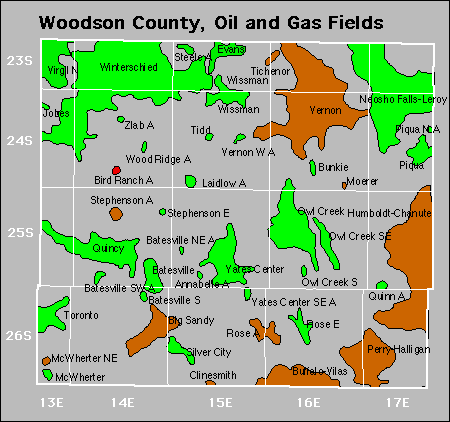

Abandoned
Annabelle
Batesville Southwest
Evans
Laidlow
Mcwherter
Rose
Steele
Stephenson
Yates Center Southeast
Zlab
Gas Storage Fields