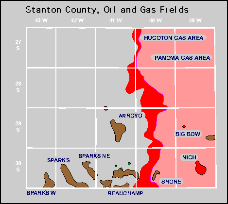
| Year | Oil | Gas | ||||
|---|---|---|---|---|---|---|
| Production (bbls) |
Wells | Cumulative (bbls) |
Production (mcf) |
Wells | Cumulative (mcf) |
|
| 1995 | 537,244 | 59 | 4,629,876 | 39,912,210 | 737 | 1,318,893,081 |
| 1996 | 641,487 | 74 | 5,271,363 | 40,377,815 | 762 | 1,359,270,896 |
| 1997 | 502,691 | 68 | 5,774,054 | 35,189,837 | 747 | 1,394,460,733 |
| 1998 | 362,440 | 71 | 6,136,494 | 28,160,632 | 754 | 1,422,621,365 |
| 1999 | 277,175 | 63 | 6,413,669 | 27,093,262 | 751 | 1,449,714,627 |
| 2000 | 361,505 | 66 | 6,775,174 | 24,956,288 | 758 | 1,474,670,915 |
| 2001 | 405,609 | 65 | 7,180,783 | 23,299,841 | 776 | 1,497,970,756 |
| 2002 | 353,496 | 68 | 7,534,279 | 21,926,065 | 774 | 1,519,896,821 |
| 2003 | 305,230 | 66 | 7,839,509 | 20,026,321 | 777 | 1,539,923,142 |
| 2004 | 247,774 | 67 | 8,087,283 | 18,612,232 | 782 | 1,558,535,374 |
| 2005 | 273,647 | 63 | 8,360,930 | 17,066,410 | 779 | 1,575,601,784 |
| 2006 | 277,189 | 74 | 8,638,119 | 15,653,040 | 764 | 1,591,254,824 |
| 2007 | 393,731 | 83 | 9,031,850 | 14,337,559 | 765 | 1,605,592,383 |
| 2008 | 344,277 | 87 | 9,376,127 | 14,419,008 | 760 | 1,620,011,391 |
| 2009 | 277,923 | 86 | 9,654,050 | 13,681,337 | 768 | 1,633,692,728 |
| 2010 | 327,164 | 86 | 9,981,214 | 12,698,690 | 775 | 1,646,391,418 |
| 2011 | 390,144 | 87 | 10,371,358 | 11,989,324 | 776 | 1,658,380,742 |
| 2012 | 338,224 | 92 | 10,709,582 | 11,375,650 | 775 | 1,669,756,392 |
| 2013 | 316,483 | 95 | 11,026,065 | 11,309,696 | 799 | 1,681,066,088 |
| 2014 | 294,251 | 98 | 11,320,316 | 12,038,869 | 846 | 1,693,104,957 |
| 2015 | 293,739 | 98 | 11,614,055 | 12,096,522 | 842 | 1,705,201,479 |
| 2016 | 275,381 | 98 | 11,889,436 | 10,993,091 | 830 | 1,716,194,570 |
| 2017 | 222,897 | 105 | 12,112,333 | 10,390,811 | 823 | 1,726,585,381 |
| 2018 | 166,917 | 102 | 12,279,250 | 9,681,429 | 818 | 1,736,266,810 |
| 2019 | 146,333 | 129 | 12,425,583 | 8,854,563 | 832 | 1,745,121,373 |
| 2020 | 108,782 | 92 | 12,534,365 | 8,520,337 | 807 | 1,753,641,710 |
| 2021 | 114,665 | 83 | 12,649,030 | 7,907,097 | 798 | 1,761,548,807 |
| 2022 | 102,466 | 79 | 12,751,496 | 7,666,585 | 804 | 1,769,215,392 |
| 2023 | 90,499 | 85 | 12,841,995 | 7,267,684 | 795 | 1,776,483,076 |
| 2024 | 98,889 | 75 | 12,940,884 | 6,809,141 | 757 | 1,783,292,217 |
| 2025 | 85,633 | 71 | 13,026,517 | 4,859,749 | 747 | 1,788,151,966 |


No Abandoned fields.