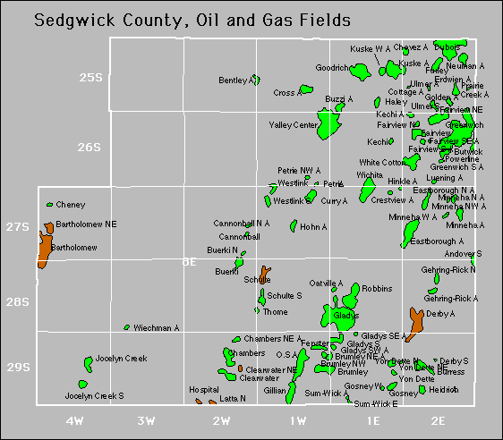
| Year | Oil | Gas | ||||
|---|---|---|---|---|---|---|
| Production (bbls) |
Wells | Cumulative (bbls) |
Production (mcf) |
Wells | Cumulative (mcf) |
|
| 1995 | 235,123 | 206 | 105,589,803 | 9,562 | 3 | 3,898,873 |
| 1996 | 235,240 | 148 | 105,825,043 | 17,503 | 3 | 3,916,376 |
| 1997 | 236,055 | 156 | 106,061,098 | 25,513 | 4 | 3,941,889 |
| 1998 | 179,861 | 135 | 106,240,959 | 27,405 | 4 | 3,969,294 |
| 1999 | 153,471 | 116 | 106,394,430 | 23,768 | 4 | 3,993,062 |
| 2000 | 156,542 | 133 | 106,550,972 | 19,871 | 4 | 4,012,933 |
| 2001 | 154,191 | 130 | 106,705,163 | 23,060 | 5 | 4,035,993 |
| 2002 | 146,889 | 132 | 106,852,052 | 27,481 | 5 | 4,063,474 |
| 2003 | 135,960 | 123 | 106,988,012 | 23,999 | 5 | 4,087,473 |
| 2004 | 133,580 | 127 | 107,121,592 | 21,831 | 5 | 4,109,304 |
| 2005 | 125,104 | 125 | 107,246,696 | 23,189 | 4 | 4,132,493 |
| 2006 | 132,657 | 125 | 107,379,353 | 19,608 | 4 | 4,152,101 |
| 2007 | 131,332 | 125 | 107,510,685 | 20,174 | 4 | 4,172,275 |
| 2008 | 125,874 | 129 | 107,636,559 | 16,314 | 4 | 4,188,589 |
| 2009 | 121,975 | 123 | 107,758,534 | 12,379 | 4 | 4,200,968 |
| 2010 | 129,088 | 127 | 107,887,622 | 11,293 | 4 | 4,212,261 |
| 2011 | 134,272 | 126 | 108,021,894 | 12,572 | 4 | 4,224,833 |
| 2012 | 153,156 | 127 | 108,175,050 | 15,796 | 4 | 4,240,629 |
| 2013 | 173,255 | 131 | 108,348,305 | 18,507 | 5 | 4,259,136 |
| 2014 | 155,153 | 135 | 108,503,458 | 17,850 | 4 | 4,276,986 |
| 2015 | 139,416 | 126 | 108,642,874 | 17,543 | 4 | 4,294,529 |
| 2016 | 127,680 | 118 | 108,770,554 | 17,796 | 4 | 4,312,325 |
| 2017 | 121,195 | 117 | 108,891,749 | 15,894 | 4 | 4,328,219 |
| 2018 | 122,441 | 114 | 109,014,190 | 13,197 | 4 | 4,341,416 |
| 2019 | 111,958 | 110 | 109,126,148 | 14,649 | 4 | 4,356,065 |
| 2020 | 98,374 | 114 | 109,224,522 | 16,390 | 4 | 4,372,455 |
| 2021 | 94,900 | 112 | 109,319,422 | 11,115 | 4 | 4,383,570 |
| 2022 | 91,824 | 110 | 109,411,246 | 9,021 | 3 | 4,392,591 |
| 2023 | 84,961 | 113 | 109,496,207 | 9,645 | 3 | 4,402,236 |
| 2024 | 79,237 | 114 | 109,575,444 | 538 | 2 | 4,402,774 |
| 2025 | 37,455 | 97 | 109,612,899 | - | - | 4,402,774 |

