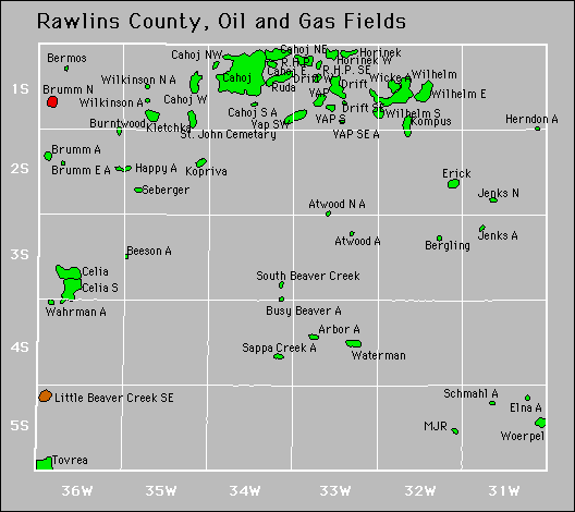
| Year | Oil | Gas | ||||
|---|---|---|---|---|---|---|
| Production (bbls) |
Wells | Cumulative (bbls) |
Production (mcf) |
Wells | Cumulative (mcf) |
|
| 1995 | 300,989 | 213 | 19,735,844 | - | - | 0 |
| 1996 | 262,995 | 167 | 19,998,839 | - | - | 0 |
| 1997 | 242,233 | 163 | 20,241,072 | - | - | 0 |
| 1998 | 209,036 | 152 | 20,450,108 | - | - | 0 |
| 1999 | 190,403 | 139 | 20,640,511 | - | - | 0 |
| 2000 | 175,117 | 135 | 20,815,628 | - | - | 0 |
| 2001 | 182,353 | 136 | 20,997,981 | - | - | 0 |
| 2002 | 180,519 | 143 | 21,178,500 | - | - | 0 |
| 2003 | 245,381 | 133 | 21,423,881 | - | - | 0 |
| 2004 | 284,774 | 164 | 21,708,655 | - | - | 0 |
| 2005 | 246,701 | 166 | 21,955,356 | - | - | 0 |
| 2006 | 239,982 | 166 | 22,195,338 | - | - | 0 |
| 2007 | 210,580 | 166 | 22,405,918 | - | - | 0 |
| 2008 | 206,969 | 155 | 22,612,887 | - | - | 0 |
| 2009 | 214,612 | 134 | 22,827,499 | - | - | 0 |
| 2010 | 184,901 | 134 | 23,012,400 | - | - | 0 |
| 2011 | 157,288 | 120 | 23,169,688 | - | - | 0 |
| 2012 | 178,512 | 123 | 23,348,200 | - | - | 0 |
| 2013 | 737,799 | 149 | 24,085,999 | - | - | 0 |
| 2014 | 1,455,460 | 191 | 25,541,459 | - | - | 0 |
| 2015 | 998,528 | 215 | 26,539,987 | - | - | 0 |
| 2016 | 654,712 | 213 | 27,194,699 | - | - | 0 |
| 2017 | 490,686 | 222 | 27,685,385 | - | - | 0 |
| 2018 | 413,039 | 242 | 28,098,424 | - | - | 0 |
| 2019 | 371,020 | 239 | 28,469,444 | - | - | 0 |
| 2020 | 297,510 | 234 | 28,766,954 | - | - | 0 |
| 2021 | 330,707 | 229 | 29,097,661 | - | - | 0 |
| 2022 | 370,436 | 238 | 29,468,097 | - | - | 0 |
| 2023 | 392,550 | 247 | 29,860,647 | - | - | 0 |
| 2024 | 389,597 | 247 | 30,250,244 | - | - | 0 |
| 2025 | 176,703 | 241 | 30,426,947 | - | - | 0 |


Abandoned
Arbor
Atwood
Atwood North
Bermos North
Jenks
Schmahl