| Year | Oil | Gas | ||||
|---|---|---|---|---|---|---|
| Production (bbls) |
Wells | Cumulative (bbls) |
Production (mcf) |
Wells | Cumulative (mcf) |
|
| 1995 | 83,814 | 32 | 3,153,846 | - | - | 0 |
| 1996 | 80,922 | 38 | 3,234,768 | - | - | 0 |
| 1997 | 78,583 | 37 | 3,313,351 | - | - | 0 |
| 1998 | 64,295 | 27 | 3,377,646 | - | - | 0 |
| 1999 | 64,531 | 28 | 3,442,177 | - | - | 0 |
| 2000 | 58,470 | 28 | 3,500,647 | - | - | 0 |
| 2001 | 54,957 | 26 | 3,555,604 | - | - | 0 |
| 2002 | 52,237 | 29 | 3,607,841 | - | - | 0 |
| 2003 | 46,510 | 26 | 3,654,351 | - | - | 0 |
| 2004 | 43,333 | 28 | 3,697,684 | - | - | 0 |
| 2005 | 37,805 | 24 | 3,735,489 | - | - | 0 |
| 2006 | 41,255 | 22 | 3,776,744 | - | - | 0 |
| 2007 | 37,076 | 25 | 3,813,820 | - | - | 0 |
| 2008 | 47,111 | 26 | 3,860,931 | - | - | 0 |
| 2009 | 57,906 | 25 | 3,918,837 | - | - | 0 |
| 2010 | 48,880 | 23 | 3,967,717 | - | - | 0 |
| 2011 | 45,546 | 22 | 4,013,263 | - | - | 0 |
| 2012 | 45,514 | 24 | 4,058,777 | - | - | 0 |
| 2013 | 47,089 | 25 | 4,105,866 | - | - | 0 |
| 2014 | 41,312 | 27 | 4,147,178 | - | - | 0 |
| 2015 | 40,514 | 25 | 4,187,692 | - | - | 0 |
| 2016 | 33,894 | 23 | 4,221,586 | - | - | 0 |
| 2017 | 43,245 | 21 | 4,264,831 | - | - | 0 |
| 2018 | 41,841 | 21 | 4,306,672 | - | - | 0 |
| 2019 | 43,176 | 25 | 4,349,848 | - | - | 0 |
| 2020 | 35,159 | 22 | 4,385,007 | - | - | 0 |
| 2021 | 38,329 | 23 | 4,423,336 | - | - | 0 |
| 2022 | 33,790 | 22 | 4,457,126 | - | - | 0 |
| 2023 | 39,880 | 20 | 4,497,006 | - | - | 0 |
| 2024 | 38,092 | 22 | 4,535,098 | - | - | 0 |
| 2025 | 32,803 | 20 | 4,567,901 | - | - | 0 |
| 2026 | 7,234 | 21 | 4,575,135 | - | - | 0 |
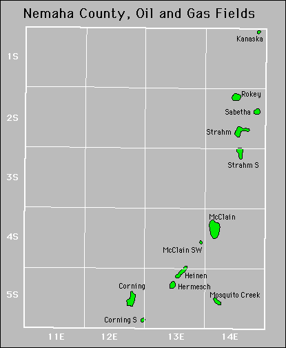

| Active | |||
|---|---|---|---|
| Corning Corning South Forest City Coal Gas Area Heinen |
Heinen Northeast Hermesch Kanaska Mcclain |
Mcclain Southwest Mosquito Creek Rokey Northeast Sabetha |
Strahm Strahm South |
Abandoned