KGS Home Page Oil and Gas Index Page County Production Page

Logan County--Oil and Gas Production


Production


Year Oil Gas
Production
(bbls)
Wells Cumulative
(bbls)
Production
(mcf)
Wells Cumulative
(mcf)
1995 364,333 108 6,592,399- - 0
1996 385,953 118 6,978,352- - 0
1997 374,100 101 7,352,452- - 0
1998 341,769 105 7,694,221- - 0
1999 271,831 98 7,966,052- - 0
2000 254,805 99 8,220,857- - 0
2001 219,281 101 8,440,138- - 0
2002 248,703 93 8,688,841- - 0
2003 445,282 106 9,134,123- - 0
2004 431,803 115 9,565,926- - 0
2005 311,326 120 9,877,252- - 0
2006 364,797 134 10,242,049- - 0
2007 336,580 149 10,578,629- - 0
2008 317,930 139 10,896,559- - 0
2009 451,305 144 11,347,864- - 0
2010 701,702 166 12,049,566- - 0
2011 964,685 201 13,014,251- - 0
2012 837,613 229 13,851,864- - 0
2013 818,640 250 14,670,504- - 0
2014 1,352,682 296 16,023,186- - 0
2015 1,274,253 318 17,297,439- - 0
2016 971,172 324 18,268,611- - 0
2017 827,037 342 19,095,648- - 0
2018 791,432 360 19,887,080- - 0
2019 698,466 379 20,585,546- - 0
2020 563,870 357 21,149,416- - 0
2021 516,242 350 21,665,658- - 0
2022 477,514 401 22,143,172- - 0
2023 451,024 360 22,594,196- - 0
Updated through 12-2023.
Note: bbls is barrels; mcf is 1000 cubic feet.

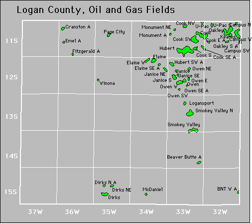
County Map

Logan County oil and gas map
oil=green, gas=red, oil and gas=brown

Fields

Also available is a text file containing field summary data for all fields in this county.
Active
American Beauty
Antelope Ridge Northwest
Antelope Springs
Antelope Springs Southeast
Antelope Springs West
B-B
Badger
Badger Southwest
Beaver Butte
Binns
Binns Northwest
Bnt West
Bridges
Bridges Northeast
Burris Draw
Butte Creek
Butte Creek Southwest
Campus North
Campus Southwest
Campus West
Chalk Buttes
Chalk Buttes West
Cook
Cook East
Cook Northwest
Cook South
Cook Southeast
Cook Southwest
Corinne
Corinne South
Cranston
Dakota Road
Dirks
Dirks North
Dirks Northeast
Dirks Southeast
Dirks West
Eagle Bluff
Eagle Bluff West
Edwards
El Kader
Elaine
Elaine Southeast
Elaine West
Elkader Townsite
Elkader Townsite Southeast
Emel
Fantasia
Fantasia South
Fitzgerald
Fitzgerald West
Funky Town
Funky Town Southeast
Funky Town West
H-R
Hell Creek
High Hat
High Hat East
High Hat Northeast
High Hat West
Hockersmith
Hockersmith South
Hubert
Hubert Southwest
Janice
Janice Northwest
Janice South
Janice Southeast
Karlin
Kyle
Kyle Northeast
Little Pyramids
Little Pyramids Northeast
Little Pyramids Southeast
Little Pyramids Southwest
Loch
Loganberry
Logansport
Logansport Northwest
Logansport West
Logo Northwest
Lone Butte
Lone Butte Northeast
Lone Butte South
Lone Butte Southeast
Lone Butte Southwest
Maurice
Maurice Northeast
Mcallaster Township
Mcdaniel
Mcdaniel East
Mcdaniel Southeast
Monument North
Monument Northeast
Monument Northwest
Monument Southwest
Monument West
National
National West
Noslen
Noslen Southwest
Noslen West
Oakley
Oakley South
Oakley Southeast
Oakley West
Orion
Orion North
Owen
Owen East
Owen North
Owen Northeast
Owen Southeast
Owen Southwest
Owen West
Page City
Pahls
Pahls Southeast
Pft
Rackmaster
Rattlesnake Ridge
Rose Garden
Rose Garden Northwest
Rose Garden West
Rumback
Scheetz
Shelter
Shs
Sky Chief
Sky Chief Northwest
Sky Chief South
Sky Chief West
Smoky Hill
Smoky Valley
Smoky Valley East
Smoky Valley North
Smoky Valley Southeast
Spirit Butte
Stratford
Stratford Southwest
Stratford West
Tom Tom
Touchstone
Touchstone West
Twin Butte
Twin Butte Creek
U-Pac
U-Pac South
Wild Butte
Wing
Wing South
Wing Southeast
Winona
Younkin
Younkin North
Younkin Northwest
Younkin South
Younkin West

Abandoned

Monument


Kansas Geological Survey
Comments to webadmin@kgs.ku.edu
URL=http://www.kgs.ku.edu/PRS/County/klm/logan.html
Data from Kansas Dept. of Revenue files monthly.